All Activity
- Past hour
-
The Atlantic cloud factory has shown slight weaknesses the last few minutes in Baker Park. Otherwise, it’s been cranking in ways only the mid-Atlantic can.
-

September 2025 OBS-Discussion centered NYC subforum
Stormlover74 replied to wdrag's topic in New York City Metro
Gfs is coming in wetter for mid to late week but the heaviest is still to our west -
I mean Florida has downpours that can stop traffic.
-
Decent win for the Terps yesterday. After beating up on the usual weaklings the first couple games, they have had 2 respectable wins to go 4-0. As usual, it will probably be a struggle to finish above 500 once they start playing legit teams in the conference.
-
Overcast and 68. A tad gloomy but dry and a Fall like feel. Nice day for working outside.
- Today
-
The CON records for the past 3 days are from the 2020 shot. I think that stretch is about as good as it gets this time of year. 28-28-27 over a 3 day stretch.
-

September 2025 OBS-Discussion centered NYC subforum
SACRUS replied to wdrag's topic in New York City Metro
69 / 58 -

September 2025 OBS-Discussion centered NYC subforum
anthonymm replied to wdrag's topic in New York City Metro
High dews too. Somehow I dont think this summer will truly end until mid October. -
40.4...we wait for 30s. Let's get some precip on a regular basis now.
-
-
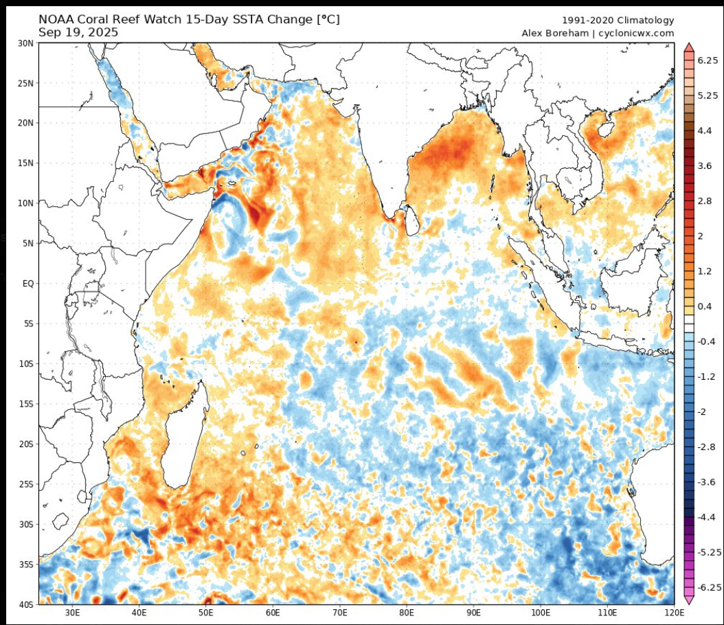
I think the question becomes when does the -IOD bottom out? Did it bottom out already or do we see another burst of strengthening in October. Either way the BOM and all models are projecting the -IOD event to continue the next few months. From the BOM: “The Indian Ocean Dipole (IOD) index has now met the negative IOD threshold (less than or equal to −0.4 °C) for 8 consecutive weeks, sufficient to be classified as a negative IOD event. The latest IOD index value for the week ending 14 September 2025 is −1.17 °C. The Bureau's model predicts the negative IOD event to continue throughout spring, with a return to neutral in early summer. This is consistent with most international models assessed and the typical IOD life cycle.” https://www.bom.gov.au/climate/enso/?ninoIndex=nino3.4&index=rnino34&period=weekly#tabs=Indian-Ocean
-
Another wet, overcast AM. A band of shwrs moved through not long ago. The sun made a brief appearance yesterday tho. Basically nickel n dime'n the precip. 0.67", 0.52", & 0.12". We'll see what today brings. 3.41" for the month so far, which is avg (3.53").
-

Central PA Summer 2025
Mount Joy Snowman replied to Voyager's topic in Upstate New York/Pennsylvania
Low of 57. -
decent amount of bob warming recently
-
September 2025 OBS-Discussion centered NYC subforum
SACRUS replied to wdrag's topic in New York City Metro
Records: Highs: EWR: 90 (1940) NYC: 95 (1895) LGA: 89 (1940) JFK: 85 (2016) Lows: EWR: 39 (1956) NYC: 40 (1871) LGA" 43 (1956) JFK: 42 (1962) Historical: 1894 - A heavy chicken house, sixteen by sixteen feet in area, was picked up by a tornado and wedged between two trees. The hens were found the next day sitting on their eggs in the chicken house, with no windows broken, as though nothing had happened. (The Weather Channel) 1894: A late season severe weather outbreak occurred across northwest Iowa, south central Minnesota and southwestern Wisconsin during the late evening hours. Several communities were impacted by this outbreak with an estimated 55 to 65 deaths, and in additional 300 injuries. The strongest tornado was an estimated F5, which tore through the counties of Kossuth, Hancock, Winnebago in Iowa, and Faribault in Minnesota. 1924 - A couple of tornadoes, one rated F4 and the other F5, tore paths of devastation through Eau Claire, Clark, and Taylor Counties in Wisconsin. The death toll was 18 and 50 people were injured. 1924: A couple of tornadoes, one rated F4 and the other F5, tore paths of devastation through Eau Claire, Clark, and Taylor Counties in Wisconsin. The death toll was 18 and 50 people were injured. 1938 - A great hurricane smashed into Long Island and bisected New England causing a massive forest blowdown and widespread flooding. Winds gusted to 186 mph at Blue Hill MA, and a storm surge of nearly thirty feet caused extensive flooding along the coast of Rhode Island. The hurricane killed 600 persons and caused 500 million dollars damage. The hurricane, which lasted twelve days, destroyed 275 million trees. Hardest hit were Massachusetts, Connecticut, Rhode Island and Long Island NY. The ""Long Island Express"" produced gargantuan waves with its 150 mph winds, waves which smashed against the New England shore with such force that earthquake-recording machines on the Pacific coast clearly showed the shock of each wave. (David Ludlum) (The Weather Channel) 1938: On this day, one of the most destructive and powerful hurricanes in recorded history struck Long Island and Southern New England. This Category 3 Hurricane was traveling at 47 mph when it made landfall near Bellport, New York. This storm caused at least 600 deaths and left approximately 63,000 homeless. 1948: A hurricane struck near Everglades City, then moved northeast through Florida to emerge into the Atlantic near Jupiter. The lowest barometric pressure was 963 millibars or 28.44 inches of mercury, and top winds were 122 mph. Three people were killed. A tornado, spawned by this hurricane, unroofed a small farmhouse and destroyed another near Homestead. (Ref. Wilson Wx. History) 1950: A severe hailstorm hit Logansport, IN and created the worst destruction seen there up to that time. The hail two inches in diameter caused a million dollars in damage. (Ref. Wilson Wx. History) 1954 - The temperature at Deeth, NV, soared from a morning low of 12 degrees to a high of 87 degrees, a record daily warm-up for the state. (The Weather Channel) 1962: Zipper fasteners on a schoolboy’s jacket and trousers were fused by a lightning strike in McCammon, ID. He did suffer severe burns. (Ref. Weather Guide Calendar with Phenomenal Weather Events 2011 Accord Pub. 2010, USA) 1969: Heavy rain in southwest Oklahoma through the 22nd, caused extensive flooding and damage to pasture and crop land. About 1,500 cattle were trapped by the high water, and many of them drowned. More than 10 bridges were washed out, and fences were removed by the floodwaters. Official rainfall measurements exceeded six inches in some locations, and an unofficial report of 11 inches in 11 hours was received from Hollister. (Ref. Wilson Wx. History) 1987 - Tropical Storm Emily, which formed in the Carribean the previous afternoon, caused considerable damage to the banana industry of Saint Vincent in the Windward Islands. Unseasonably hot weather continued in Florida and the western U.S. Redding CA and Red Bluff CA, with record highs of 108 degrees, tied for honors as the hot spot in the nation. (The National Weather Summary) 1988 - Thunderstorms produced high winds and locally heavy rain in the southwestern U.S. One thunderstorm in west Texas produced wind gusts to 86 mph at Dell City completely destroying an airport hangar. A Cessna 150 aircraft housed within the hangar was flipped over and snapped in two. Thunderstorms produced large hail in east central Utah, while snow blanketed some of the higher elevations of the state. (The National Weather Summary) (Storm Data) 1989 - Hurricane Hugo slammed into the South Carolina coast about 11 PM, making landfall near Sullivans Island. Hurricane Hugo was directly responsible for thirteen deaths, and indirectly responsible for twenty-two others. A total of 420 persons were injured in the hurricane, and damage was estimated at eight billion dollars, including two billion dollars damage to crops. Sustained winds reached 85 mph at Folly Beach SC, with wind gusts as high was 138 mph. Wind gusts reached 98 mph at Charleston, and 109 mph at Shaw AFB. The biggest storm surge occurred in the McClellanville and Bulls Bay area of Charleston County, with a storm surge of 20.2 feet reported at Seewee Bay. Shrimp boats were found one half mile inland at McClellanville. (National Weather Summary) (Storm Data) 1995: The earliest snow on record fell across southwest Kansas with most areas reporting 2 to 3 inches with isolated amounts up to 6 inches. This was the earliest snowfall ever recorded at the Dodge City Airport. This was also the only time there was measurable snowfall for the month of September. A total of 1.3 inches fell at the Dodge City Airport. Rochester, MN saw a trace of snow, their earliest such occurrence on record. Along with the snow, many areas reported record low temperatures. Miles City, MT fell to 19°, their coldest September temperature on record. Other daily record lows included: Valentine, MT: 11°, Chinook, MT: 13°, Chester, MT: 15°, Glasgow, MT: 15°-Tied, Boulder, MT: 16°, Havre, MT: 18°, Williston, ND: 18°, Bozeman, MT: 19°, Lewistown, MT: 19°, Livingston, MT: 19°, Helena, MT: 20°, Great Falls, MT: 20°, Cut Bank, MT: 20 °F. (Ref. Many Additional Temperatures Listed On This Link) 1998: Nine years after Hurricane Hugo struck Charleston, SC, the city was inundated with 10 inches of rainfall in less than 8 hours causing major flooding. A weakened Hurricane Georges swirled through the islands of the northeastern Caribbean with winds of 115 mph. The storm had earlier been a very strong category 4 hurricane. The eye of the hurricane passed within two miles of St. Croix and crossed the entire island of Puerto Rico from east to west. Winds were estimated at 115 mph and up to 20 inches of rain fell. (Ref. AccWeather Weather History) 2002: The worst tornadoes to strike Indiana in 12 years raked an area from the southwestern corner of the state to Indianapolis. At least 5 tornadoes were confirmed by the National Weather Service. Excellent warnings resulted in very low numbers of injuries and no fatalities. Most communities had at least 20 minutes lead time before the twisters struck. (Ref. Wilson Wx. History) 2005: Gulf of Mexico: After raking the Florida Keys on the 20th, Hurricane Rita strengthens into a Category Five storm on the Saffir-Simpson over the open waters of the Gulf of Mexico. By 11 PM EDT, the central pressure drops to 897 mb or 26.49 inches of mercury the third-lowest pressure on record in the Atlantic with maximum sustained winds of 175 mph. (Ref. WxDoctor) -

September 2025 OBS-Discussion centered NYC subforum
bluewave replied to wdrag's topic in New York City Metro
Mid to perhaps upper 80s Tuesday as the models are slowing the front down. New run Old run
-

September 2025 OBS-Discussion centered NYC subforum
doncat replied to wdrag's topic in New York City Metro
Astro summer rain here of 8.34" was 4th lowest in 45 years of record. -
September 2025 OBS-Discussion centered NYC subforum
SACRUS replied to wdrag's topic in New York City Metro
68 / 56 partly cloudy onshore easterly flow. Warmer tomorrow / Tue low / mid 80s Tuesday then cutoff barrage Wed - Sun and perhaps the cloudiest and wettest period in a while. Beyond there near normal. -
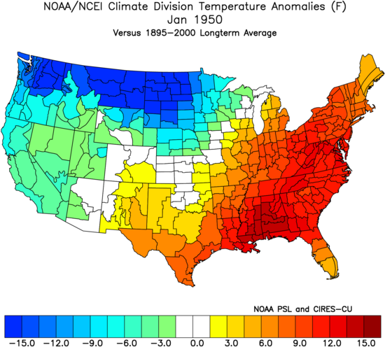
January 1950 still stands as the warmest on record in Atlanta following the lower 96 ACE that season. Time Series Summary for Atlanta Area, GA (ThreadEx) - Month of Jan Click column heading to sort ascending, click again to sort descending. 1 1950 55.4 0 2 1880 54.3 0 3 1974 53.2 0 4 1937 53.0 0 5 1907 52.2 2 6 2017 52.0 0 7 1949 51.8 0 8 2023 51.7 0 9 1932 51.2 0 10 1890 51.0 0
-

September 2025 OBS-Discussion centered NYC subforum
wdrag replied to wdrag's topic in New York City Metro
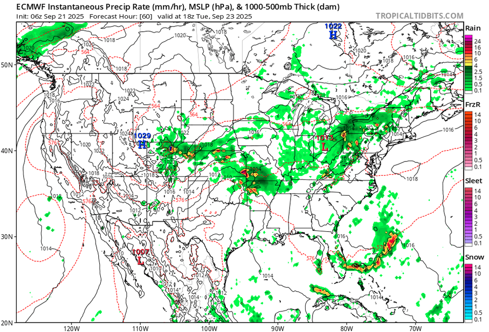
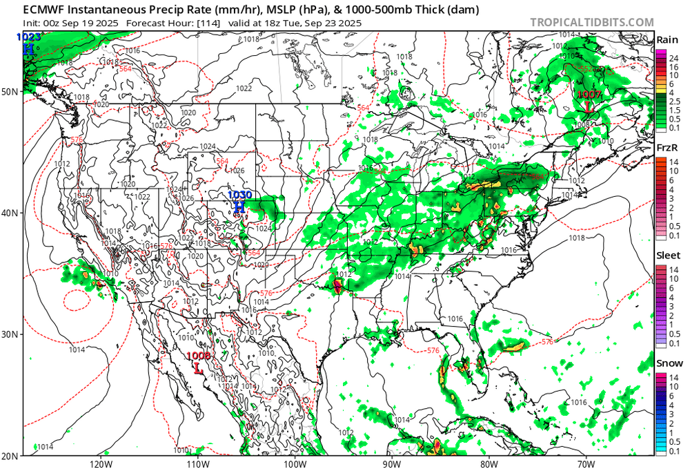
No thread attm--maybe something late Monday???: need more ensemble support but looking at widespread 1-3 rainfall totals Tuesday afternoon-next Sunday with iso 5+ POSSIBLE. Depends on evolution and track of developing UA low Ohio Valley middle and end of next week... ie stall the showery late Tuesday surface CFP just to our south Wed-Sunday with weak waves of low pressure. LONG Ways off but am not too alarmed by the recent dryness... happens and then a blast of rain. We do need that OH Valley LOW to form and eject across NJ next Sunday as it finally weakens. Otherwise wait til October. -
Neat old documentary (1978) about the 1938 hurricane https://youtu.be/cCMoqMujLh4?si=dlderiR9ma4UBqPG
-
How things have changed…
-
BOS -1.5F MTD ORH is 0.0.
-
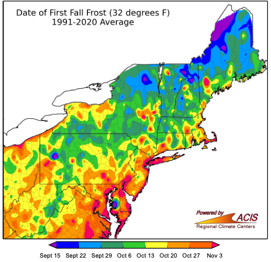
So that was an arctic airmass and basically ideal radiating conditions. If you didn’t get to frost it’s not in your climo anymore for the date…
-
there is insulation under the roof so it radiates better than the glass