All Activity
- Past hour
-

The return of the elusive Nor'easter. Drought buster or bust?
IronTy replied to dailylurker's topic in Mid Atlantic
I did hear some moderate sounding rain at one point last night outside my window while in bed. I guess that counts for something. -
It was already beginning to grow more banded when it got into our area, and especially your's. There was one good initial pulse, and then it lightened up and I knew. The good ones come in like a wall. The rest of this storm will be banded crap.
-
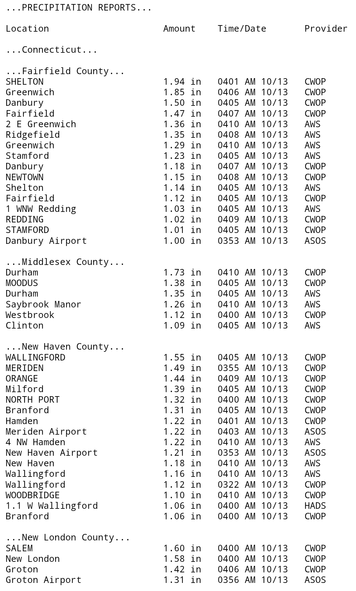
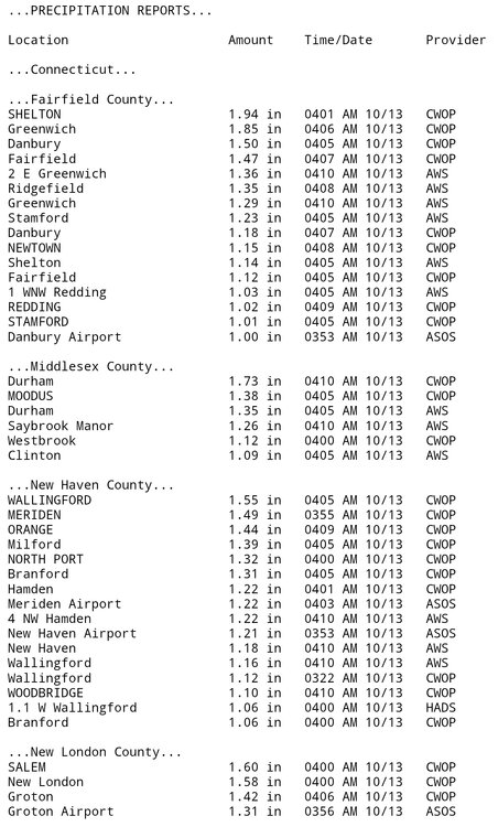
 1.75 here still raining off and on
 -
Hi all - got a couple of questions if I may. I tried posting this one thing in the Meteorology 101 section but it seems like no one pays attention there, so figured I'd try here. My son's looking to go into meteorology, and I was wondering about a couple of things. First - since we live in VA, he was looking to most likely do the program at VT for meteorology. What are folks' thoughts on that program vs other ones around the east? It seems pretty good (we just visited), but it sounds like there are other ones around that may be as good or better - e.g. PSU, UMd, FSU. Rankings are all over the place, so not reliable at all. One disadvantage is that the VT program is only undergrad. We were wondering how much that might matter though - if desired he could do undergrad at VT and graduate school at one of the others. Also it seems like most meteorology careers don't require graduate degree - fair to say? Cost of course is a consideration, and a big driver towards VT - getting in-state tuition. Other question I had in the other thread is about AI and about the impact of NOAA cuts. Thoughts? (below is link to the thread) Thanks!
-
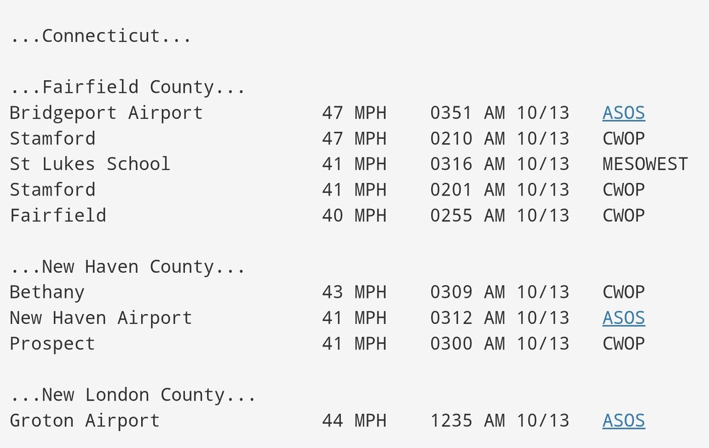
Been a pretty good rain event for Southern CT.
-
0.3" here
-
There are execeptions.... but it's usually not a great sign when the precipitation struggles to get going...aside from a round of showers yesterday AM, it didn't really rain until mid-late evening. Obviously this is crude analysis because I don't dig in and forecast October rain events, but usually the "winners" get going with ease. January 7, 2024 was a great example of that...I got giddy when OES started up ahead of schedule and that one did not dissapoint. Also works for changeover deals....Dec 1992 and March 2018....both instant crash-flips around mid night and off to the races. April 1997....late PM flip-bang. If you're squnting to see precip for hours on end or taking cat paws up the sphincter unlubed for several hours, you can probably catch up on sleep and avoid dissapointment.
-
 Fire at nursing home resulting in everyone being evacuated to riverhead pbmc. Didn't call orient though.
 -
0.20” rain. Radar not looking promising. Breezy though with spotty -RADZ and some drier air working in aiding some evaporative cooling.
-
We had a lot of severe erosion worth massive waves right now on gardiners bay
-
The only month last winter that suppression was an issue for NYC Metro was January. Those teleconnections could have worked for us prior to 18-19 for us especially in an El Niño dominant STJ pattern. But the split flow and overpowering Northern Stream of the Pacific Jet instead caused the Southern stream suppression. Both December and February were fairly wet but the storm tracks were too warm to our west for a major snow event.
-
JB is an idiot. Karen met all the qualifications of a subtropical system, which is why it got named. Had nothing to do with the "climate" agenda. How anyone still pays attention to that idiot is a conspiracy in itself.
-
 Sharp cutoffs continue to be a feature. This will be fun this winter. I'm up to 0.30" event total from 0.21" overnight. Wind is howling this morning. I didn't witness any power outages as of yet in my travels out this way.
- 550 replies
-
- 1
-

-
- heavy rain
- damaging wind
- (and 2 more)
-
The winds are fun though. It’s been a while.
-

Spooky Season (October Disco Thread)
40/70 Benchmark replied to Prismshine Productions's topic in New England
Last season was the most accurate snowfall forecast I have ever had, and I actually eneded up being too warm. I feel like I have made some adjustments to better account for CC moving forward....not that I'm going ot nail it every year, but hopefully mitigate the disasterous performances. -
I can't have much more than a 1/2"...maybe .60". All I can say is I'm glad it's October and not January. I would have lost it....just like winter, scooter telling me I'm all set, only to still wind up one of the lower totals.
-
We could have used some of that up here in Nova Scotia, we haven’t had a good meaningful rain in months. The rivers and streams are all but dried up to nothing and the water supply is dwindling rapidly, it’s pretty dire honestly.
-
2025-2026 ENSO
40/70 Benchmark replied to 40/70 Benchmark's topic in Weather Forecasting and Discussion
Pretty sure he's just in a bruised and battered persistence "forecasting" mindset. -

E PA/NJ/DE Autumn 2025 Obs/Discussion
BBasile replied to PhiEaglesfan712's topic in Philadelphia Region
About to crack one tenth of an inch for the storm. Winds still gusting into the 20's. Currently have horizontal mist. 55F -
 Officially past 2 inches for the entire event Sat-now at Holmdell NJ, Queens and Stony Brook on LI. Suggests to me that iso 4 within the realm of possibility. Otherwise bigger amounts of at least 4" will probably be coastal RI out to Cape Cod.
- 550 replies
-
- 1
-
-
- heavy rain
- damaging wind
- (and 2 more)
-
They are running the ferry? Looks like Block Island is shut down today.
-
Isolated spots may be pick up an additional 2" between now and 8PM, along the coasts... IF convection emerges this afternoon as modeled by the HRRR. Looks like pretty good impact, travel wise per TV reports and what has been posted here this morning. Anticipate DELAYS and maybe some detours. Will post a summary report tomorrow morning around 9A, for CoCoRaHs 3 day totals but looking good. Wind driven rains this morning... intermittent in some spots.
- 550 replies
-
- 2
-
-
- heavy rain
- damaging wind
- (and 2 more)
-
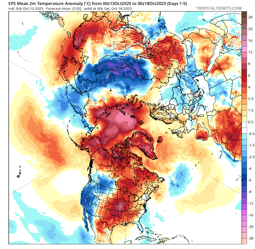
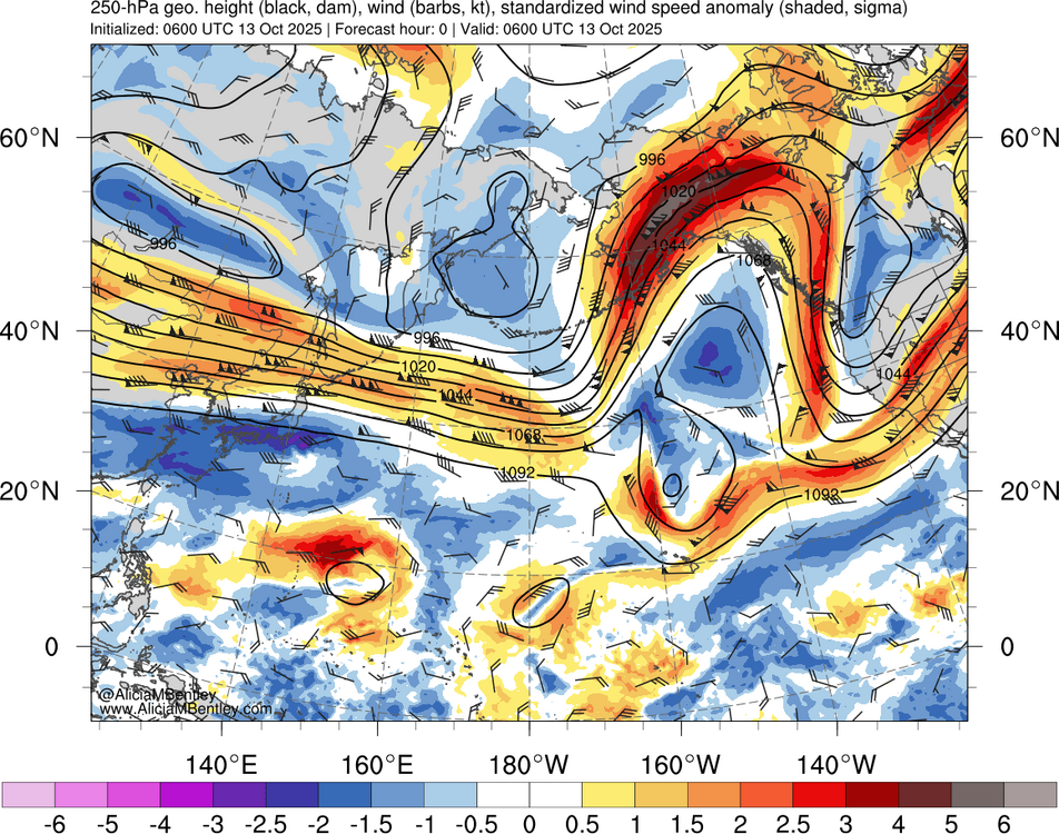
Another 5 sigma jet max for Alaska. The strong gradient between the record SSTs over the WPAC and Siberian cold is driving this. So this leads to the continuing warmth for North America.

-
Yeah. Woke up to no power and some damage here.