All Activity
- Past hour
-
ICON completely whiffs even getting close Monday as it has the energy off Mexico retrograde further southwest.
-
I kinda was in the middle by getting grazed by both, hopefully the next one targets us. Still no complaints on Dec 2nd. My measurable snow this season: Nov 9- 2.5" Nov 27- 0.1" Nov 29/30- 3.1" Dec 1/2- 1.2"
-
27.1° -SN 8.5”
-
RDPS is significantly improved too (though not enough to help NOVA but Short Pump makes out like a bandit). It generally follows the positive aspect I've been highlighting which is the secondary bands of NS energy being modestly further west
-
quickly 100% snow
-

2025-2026 ENSO
40/70 Benchmark replied to 40/70 Benchmark's topic in Weather Forecasting and Discussion
I didn't say anyone called for one. The comment was made that the upcoming pattern is unfavorable for one, and you responded with semantics concerning climo. I don't agree that there is no valuein it...there is absolutely value in highlighting an enhanced risk, and this upcoming pattern isn't one...otherwise, WTH are we doing?? Isn't forecasting the goal? -

December 2025 regional war/obs/disco thread
WinterWolf replied to Torch Tiger's topic in New England
Cold is here bro…that’s the point. Decent Track is what we want now, cuz cold is available. -
50/50 r-s mix chelmsford.
-

2025-2026 ENSO
brooklynwx99 replied to 40/70 Benchmark's topic in Weather Forecasting and Discussion
i do think a larger storm is possible after the 15th into early Jan if the -NAO holds on and heights rise out west a bit more with help from tropical forcing, but that's way out there -
2025-2026 ENSO
brooklynwx99 replied to 40/70 Benchmark's topic in Weather Forecasting and Discussion
who was calling for one? I don't think anybody has mentioned the risk for one... seems like light to mod events generally my point was that saying that a pattern isn't conducive for historic storms isn't really saying all that much. you can say that about most patterns. it's like saying most football players won't make it to the NFL. it's implied -
Just went outside and wow…it’s all basically a sheet of ice. Hard to tell because it’s dark but some definite accretion on the trees at least. It’s also like snowing/sleeting.
-
Yeah, precip/snow shield expanded a little further north
-
0.87 total today
-
So far it looks like it should at least hold from its 18z improvement I think. Still sorta does the Nam more connection with the low off western Mexico but seems like it should be fine for it.
-

December 2025 Short/Medium Range Forecast Thread
Carvers Gap replied to John1122's topic in Tennessee Valley
-
2025-2026 ENSO
40/70 Benchmark replied to 40/70 Benchmark's topic in Weather Forecasting and Discussion
Come on, dude...you know what he means. A big se ridge isn't how you get one. -

Central PA Fall Discussions and Obs
Blizzard of 93 replied to ChescoWx's topic in Upstate New York/Pennsylvania
I was on a Teams call today & one of the guys was located in Middletown directly across the street from MDT. I watched it snow heavily through his window on my screen between 9:30 & 10. -
Looks like Icon will come north now, snow on doorstep at 60, strung out mess also
-
Rapidly changing back to snow now. Probably 80% snow and 20% sleet. Total accumulation still at 3.8" on the day but we should add a little to that now.
-
Finally flipped back to snow here in the last 15 min
-
SN, 23/22°F, Additional 1.7", Now up to 6.5" total
-
Central PA Fall Discussions and Obs
Blizzard of 93 replied to ChescoWx's topic in Upstate New York/Pennsylvania
Look again… it’s predominantly snow or snow/mix until a little after 10 am… -

Central PA Fall Discussions and Obs
Jns2183 replied to ChescoWx's topic in Upstate New York/Pennsylvania
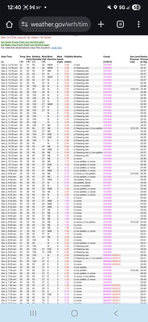
This says freezing rain for most of the storm Sent from my SM-S731U using Tapatalk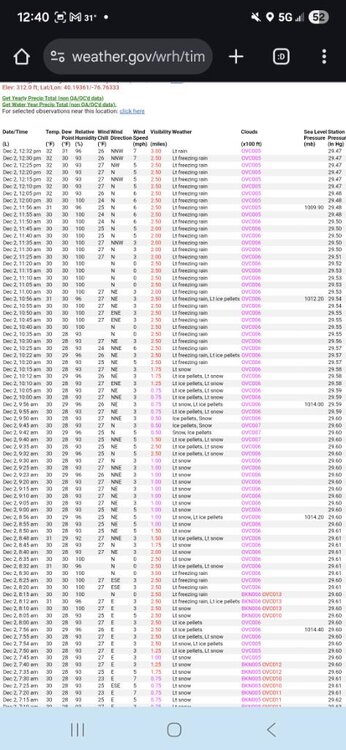
-
Central PA Fall Discussions and Obs
Blizzard of 93 replied to ChescoWx's topic in Upstate New York/Pennsylvania
Soon my friend, hopefully you & the Lanco crew cash in on the next one! The pattern looks potentially active through the next week, so hopefully it won’t be long until we are back tracking a specific chance. -