All Activity
- Past hour
-
 Btw when it was in the 90s in October 2019 it felt hot as balls despite lower sun angle lol
 -
Forget the 80s, that's not what makes September a nice month. 70s for highs and lower dews is what makes a nice September. Extended summer is just more 70 degree dewpoints and crap weather as far as I'm concerned.
-
 Hurricane next week. Remember Irene and the earthquake a week before ?
 -

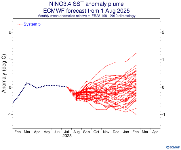
2025-2026 ENSO
brooklynwx99 replied to 40/70 Benchmark's topic in Weather Forecasting and Discussion
ECMWF seasonal is pretty close to what myself and some others are thinking... pretty solid tendency for -EPO early on with the TPV likely displaced into SE Canada at times. also a bit of a signal for blocking early on, too? wouldn't be shocking with the -QBO sure, it likely ends up 1-2F AN, but nothing prohibitive, and there will be spells where the pattern is actually conducive for snowfall. i'll take it -
 Global warming?
 -
yeah it was cool, here's a neat moon shot video from last night https://www.foxsports.com/watch/fmc-9drb0dd9yytveey9
-
 80-82 in September is fine-that's extended summer to me. Sun angle is lower so doesn't feel as hot
 -
Exactly! Why would you want extended summer then?
-
 That was real WTF situation. I ran out the house. Today was mild - felt it tho. Could have been a truck in my mind I suppose but these go on for like 10 seconds. we need a quake thread if this keeps up
 -
 Yeah I felt the quake, I thought Chris Christie dropped on my roof.
 -
 Was just thinking the same thing. Never remember this frequency of quakes growing up. Nothing beats the one back in the Spring of 24. That was in a class by itself at least in my area.
 -

2025-2026 ENSO
40/70 Benchmark replied to 40/70 Benchmark's topic in Weather Forecasting and Discussion
Is there any winter correlation for having such a sustained and robust +AO/NAO this time of year? -
Be happy it's not Winter July was the 6th consecutive month of +NAO. Cumulative NAO value of +3.75 in that time. July was the 5th consecutive month of +AO. Cumulative AO value of +3.2 in that time. It's looking like August may be the 7th consecutive +NAO month, with a projected Aug 1-15 value coming in around +1. The odds of having 7 consecutive months in either direction is 1/64.
-

2025-2026 ENSO
Stormchaserchuck1 replied to 40/70 Benchmark's topic in Weather Forecasting and Discussion
The CPC monthly page has updated July was the 6th consecutive month of +NAO. Cumulative NAO value of +3.75 in that time. July was the 5th consecutive month of +AO. Cumulative AO value of +3.2 in that time. It's looking like August may be the 7th consecutive +NAO month. The odds of having 7 consecutive months in either direction is 1/64. -
hon hon hon oui oui
-
 Eventually every season will just be summer/spring
 -
 Reddish look to the moon last night too.
 -
-

2025-2026 ENSO
PhiEaglesfan712 replied to 40/70 Benchmark's topic in Weather Forecasting and Discussion
I do think a destructive storm like Hurricane Andrew is possible, but I feel like the general pattern this year is an active Pacific and a quieter Atlantic. This has a 1992 feel to it. -
 2.7 for the aftershock.
 -
 Is it just me or more earthquakes around here than normal?
 -
Yes, felt it here. Was brief but felt it for sure.
-
Polar jet far to the North, with High pressure to the North of us West to East, lessens the possibility of a re-curve "if" a hurricane were to near the US SE Coast. Depends on the strength of the Bermuda High as well.
-
 Anyone else feel the tremor?


