All Activity
- Past hour
-

2025 Lawns & Gardens Thread. Making Lawns Great Again
Baroclinic Zone replied to Damage In Tolland's topic in New England
Add another tick and disease risk to the list https://www.boston.com/news/health/2025/08/22/yet-another-disease-carrying-tick-species-has-entered-mass/ -
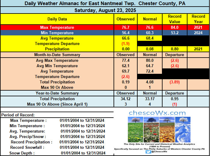
Today will be the warmest and somewhat humid day for the rest of August. A couple showers are possible late today and tonight with a cold front. Here in East Nantmeal we could really use the rain as we are well on the way to finishing this August as the driest such month since I began keeping records in 2004. So far I have only measured a scant 0.19" in August. The previous low month was back in 2005 when only 1.24" fell. This next week may be one of the best weather weeks of the year! Autumnal weather with low humidity and unseasonably cool temperatures for the final week of August. Highs on Wednesday will struggle to escape the 60's for high temperatures across the higher ridge areas. Highs for the week will be mainly in the low to mid 70's with nights well down into the 50's with some 40's possible in valley locations.
-

E PA/NJ/DE Summer 2025 Obs/Discussion
ChescoWx replied to Hurricane Agnes's topic in Philadelphia Region
Today will be the warmest and somewhat humid day for the rest of August. A couple showers are possible late today and tonight with a cold front. Here in East Nantmeal we could really use the rain as we are well on the way to finishing this August as the driest such month since I began keeping records in 2004. So far I have only measured a scant 0.19" in August. The previous low month was back in 2005 when only 1.24" fell. This next week may be one of the best weather weeks of the year! Autumnal weather with low humidity and unseasonably cool temperatures for the final week of August. Highs on Wednesday will struggle to escape the 60's for high temperatures across the higher ridge areas. Highs for the week will be mainly in the low to mid 70's with nights well down into the 50's with some 40's possible in valley locations.
-
Nothing lasts foreverAnd we both know hearts can changeAnd it's hard to hold a candleIn the cold November Rain. I'll start the November thread.
-
Ooof. Thinking dormancy on 8/24 is brutal. Not sure how you guys deal with that… I have many flowers that just started blooming again with the summer heat stress behind. Moving now to the second peak for garden scapes after summer heat stress and before first frost. The drought though is keeping the water bill up but at least it’s without the high energy bills. With how beautiful and AN our falls have been dormancy isn’t on my mind until mid November.
-
Some leaves falling off the trees in the breezier conditions. Too dry. Probably too late to save a good fall foliage display in SE NH.
-
Yeah it must be rough there with the SW facing hillside. At least dormancy is coming soon.
-
Made it all the way down to 49.6 here this morning. So close to the first 40s of the season.
-
 Thanks. I missed it. My apologies.
 -
So far in August I have had .007" of rain. In July I had 1.43" but it was all nickels and dimes with no one shower bringing more than .25". For June, I had a bit more than 3" but half of that was in the first week of the month. Our grass is brown and shrubs are wilting. Even lilacs. Lots of early leaf drop too. I'm glad we went into the summer with the water table being okay but the surface is amazingly dry. I think about farmers back in the day without deep wells and no way to irrigate crops. It must have been so scary back then, worrying about having enough food to last the winter.
-
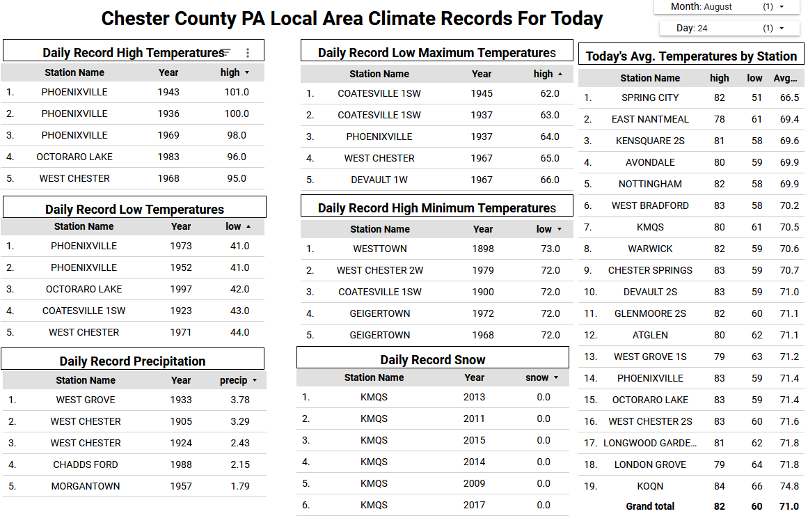
 Records: Highs: EWR: 95 (1947) NYC: 94 (1972) LGA: 93 (2020) JFK: 94 (1995) Lows: EWR: 52 (1940) NYC: 52 (1890) LGA: 55 (1971) JFK: 55 (1962) Historical: 1785: A hurricane ravaged the area from St. Croix, Virgin Islands to Cuba during the last week of August beginning on this date. Over 142 people were reported dead from storm's impact. (Ref. Wilson Wx. History) 1814: The British army invaded Washington and set fire to the city on August 24th. The next day a line of severe thunderstorms spawned a tornado in Washington that killed several British solders and caused significant damage to the city. The heavy rainfall associated with the storm helped extinguish the fires that were burning throughout Washington. (p.31 Washington Weather Book 2002 by Ambrose, Henry, Weiss) 1827: A powerful hurricane struck North Carolina. The storm caused the Diamond Shoals Lightship to break away from its anchorage and drift away. Two crew members were lost during the storm. (Ref. Wilson Wx. History) 1893: A hurricane moved northeast of Puerto Rico, then moved north close to the New Jersey shore and into western Long Island, NY during the pre-dawn hours. Cape Henry, VA, measured a gust to 128 mph. Philadelphia, PA had a maximum 1-minute wind velocity of 55 mph. New York City recorded a daily rainfall record of 3.61 inches. This hurricane, still a Category 2 off New Jersey and washed away the Hog island. This storm retained its hurricane strength throughout its passage across New England, decreasing to tropical storm status over the mouth of the St Lawrence River. (Ref. Wilson Wx. History) 1906 - A cloudburst deluged Guinea, VA, with more than nine inches of rain in just forty minutes. (David Ludlum) 1910: An unusually strong dry cold front caused a considerable drop in temperature at Denver, CO. From 3 PM to Midnight the temperature fell from a high of 93° to a low of 40°. Sustained winds of 44 mph were reported during the late afternoon. The low of 40° set a daily record low and tied a record low for August. Cheyenne, WY dropped to 30°, their earliest freeze on record. (Ref. Wilson Wx. History) 1936: This date was a real scorcher across the Central and Northern Plains. Sioux Falls hit 109°, tying their second highest temperature on record. The record is 110 °F that was set on June 21, 1988. In fact, three of the four hottest temperatures ever recorded in Sioux Falls occurred in 1936, which not coincidentally is the hottest summer on record across much of the Northern Plains. (Ref. Wilson Wx. History) 1948: The following locations recorded their hottest August temperature: Mather, WI: 107° (also their hottest day on record), Mondovi, WI: 104°, Winona, MN: 103°, and Rochester, MN: 100°, also tying their hottest August temperature with several other dates: 8/3/1930, 8/4/1947, 8/15/1936, 8/23/1948. (Ref. Wilson Wx. History) 1952: It was a record braking chilly morning across the Mid-Atlantic States. Layton, NJ dropped to 33° and Runyon, NJ fell to 37°. It came close to the states all-time record low for August that occurred at Layton & Charlottesburg on 8/25/1940 when they fell to 32°. Other daily record lows included: Elkins, WV: 40°-Tied, Binghamton, NY: 45°, Buffalo, NY: 47°, Allentown, PA: 47°, Wilmington, DE: 48°, Baltimore, MD: 48°, Huntington, WV: 48°-Tied, Harrisburg, PA: 49°-Tied, Richmond, VA: 50° and New York (LaGuardia Airport), NY: 59°. (Ref. AccWeather Weather History) 1968 - Lightning struck the Crawford County fairgrounds in northwest Pennsylvania killing two persons and injuring 72 others. (The Weather Channel) 1974: Central New Jersey--A brief lightning storm killed one person on the beach in Long Island Township. Maine--A line of thunderstorms developed across the southern part of the state. Severe lightning caused two deaths at Rockland. (Ref. Lightning-The Underrated Killer.pdf) 1975: Lansdale, PA in Montgomery County received over 5 inches of rain in 2 hours. (Ref. Wilson Wx. History) 1984: Southern Alaska: Remnants of Tropical Storm Holly bring heavy rains and snows to parts of southern Alaska. Four-foot snow drifts are reported at Denali National Park. (Ref. WxDoctor) 1987 - Autumn-like weather prevailed across the north central and northeastern U.S. Seven cities reported record low temperatures for the date, including Saint Cloud MN with a low of 37 degrees. Temperatures in Florida soared to 98 degrees at Pensacola and 99 degrees at Jacksonville. Thunderstorms produced heavy rain in the Southern High Plains Region, with 5.40 inches at Union NM, and 7.25 inches reported west of Anthony NM. (The National Weather Summary) 1988 - Thunderstorms in the Delaware Valley of eastern Pennsylvania produced wind gusts to 95 mph around Philadelphia, and gusts to 100 mph at Warminster. A tropical depression drenched the Cabo Rojo area of southwestern Puerto Rico with up to ten inches of rain. San Juan received 5.35 inches of rain. (Storm Data) (The National Weather Summary) 1989 - Late afternoon and evening thunderstorms produced severe weather in eastern Montana and western sections of the Dakotas. Thunderstorms in Montana produced wind gusts to 76 mph at Jordan, and golf ball size hail at Rock Springs, which collected three to four feet deep in ditches. Lewiston ID reported a record 1.50 inches of rain for the date, and a record rainfall total for August of 2.63 inches. (The National Weather Summary) (Storm Data) 1991: Eastern North Dakota suffered severe hail damage from stones that were as big as 6 inches near Lisbon. Windows were smashed, cars heavily damaged, holes punched in roofs and 16,000 acres of crops were destroyed. (Ref. AccWeather Weather History) 1992 - Hurricane Andrew made landfall in southern Florida at 4:30 AM on this day. The high winds caused catastrophic damage in Florida, with Miami-Dade County cities of Florida City, Homestead, and Cutler Ridge receiving the brunt of the storm. About 63,000 homes were destroyed, and over 101,000 others were damaged. This storm left roughly 175,000 people homeless. As many as 1.4 million people were left without electricity at the height of the storm. In the Everglades, 70,000 acres (280 km2) of trees were knocked down. Additionally, rainfall in Florida was substantial, peaking at 13.98 in (355 mm) in western Miami-Dade County. About $25 billion in damage and 44 fatalities were reported in Florida. 2005: Tropical depression 12 would be named Tropical Storm "Katrina" during the morning. Katrina went on to become the costliest and one of the most deadly hurricanes to ever strike the U.S. (Ref. Wilson Wx. History)
 -

2025 Lawns & Gardens Thread. Making Lawns Great Again
jbenedet replied to Damage In Tolland's topic in New England
Went to wentworth greenhouse in Rollinsford to pick up some JG Heat and drought mix to reseed the lawn. Found out they carry everything except that. Spoke to them directly about it and they said the brown areas would come back; it’s just stressed. I said no, it’s BARE after thatching. What I need is a mix that won’t get scorched. I dunno what this buyer is doing but my areas most in need of reseeding are the hottest patches with most direct sun. That also should be the case for most. I get over 8 hours of direct sun in these parts even in August. JG heat and drought is the only seed rated to withstand 100F. People need to realize that in prolonged direct sun, at peak diurnal ISR, unshaded areas in your lawn can get near these temps. That’s what the scorching is telling you… Also, guy, it’s getting warmer here… Anyway I went to a local competitor and reseeded with what I needed to be ready for next years onslaught of 90+ clear weather days… -
Picked up an unexpected .05” rain early this am.
-
Records: Hi That image was from the 1903 storm. If you look at the sight it references it below just odd formatting of the web page..
-
GFS offers chances at some rain in the extended...mildly interesting anyway. It's all we have to track this time of year.
-
76 / 67 partly cloudy . Mainly dry front with some scattered showers pushing into EPA. Clouds arrive in the next few hours but clear out later in the afternoon. Only scattered / isolated showers. Monday the warmest day of the next 7 - 10 with mid / upper 80s before the trough builds in. Cooler overall the rest of the month before moderation to warmer by the 3rd.
-
73/68 currently here. Dew point up a little this AM., can feel the difference, but cooler weather is on the way.
-
As reverse Google searches failed to turn up the photo or information about it, I turned to AI to make an estimate. Here's the AI assessment: Historical Photo Assessment Report **Subject:** Flooded street scene with people in a rowboat **Probable Date Range:** 1895–1915 1. Photographic Technology - Sepia tone and matte finish consistent with late 19th to early 20th century printing. - Likely a gelatin silver or albumen print—popular in this timeframe. - Large-format camera, outdoor composition—consistent with photos from ~1890 onward. - Not a tintype or daguerreotype, which rules out pre-1880s. 2. Clothing & Fashion - Men: Bowler hats, flat caps, sack coats, and high-buttoned jackets → typical 1890s–1910s. - Children: Boys wearing knee-length trousers and caps, common pre-1920. - A girl figure (left of boat): coat, knee-length skirt, stockings → typical children’s dress of 1900–1915. - No bobbed hair or shorter dresses, which rules out the 1920s onward. 3. Hairstyles & Grooming - Men appear clean-shaven or with short mustaches, no full Victorian-style beards. - The clean-shaven look became dominant after 1890. 4. Architecture & Built Environment - Wood clapboard siding (left) and brick commercial block (right) → typical northeastern/mid-Atlantic U.S. urban architecture c. 1880–1910. - Storefront signage: painted glass with “High Grade Hats for Cash / Cigars” → typography and phrasing characteristic of turn-of-the-century advertising. 5. Technology in Scene - No automobiles, no electric poles with visible wiring, no modern streetlamps. - Rowboat transport → indicates pre-automobile flood response. - Absence of cars suggests pre-1915 urban America. 6. Photographic Context - Group portrait-like arrangement: people posed but outdoors. - Mix of children and adults, plus deliberate posing, suggests community or news documentation typical of early disaster photography. Overall Assessment Bringing together photographic style, clothing, architecture, and technology, the most likely date range for this photograph is 1895–1915, with a strong clustering around 1900–1910.
- Today
-
uninstall incoming reclaiming open windows
-
If that’s October sign me up.
-
-
Nice thundershower here.
-
In June he wakes up with the sheets soaking wet and 2ply TP sticking in between his cheeks
-
Of note, unless that is a simulated photo of what it might have looked like, it has to be from a different storm. It was probably taken in the late 19th century or early 20th century, perhaps during the 1893 hurricane or 1903 hurricane; 1903 would probably be more likely as that hurricane made landfall in NJ while the 1893 hurricane passed just east of NJ). No photos were taken during the 1821 hurricane. The first actual photo (heliograph) was taken in 1822.