All Activity
- Past hour
-
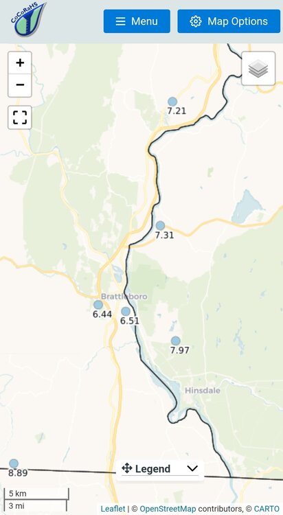
I had about 3.8" rain for July/Aug which is dry for this part of New England. I know some surrounding Franklin Co. towns are lower than that. Coming down Rt 2 tonight I could see premature leaf fade and droop, especially in that Fitchburg to Hubbardston corridor. There was also a few red lit swamp maples.
-
Ryan Hall video I was watching, he said 2010-11 was an 85 percent analog match for this coming winter. Not exactly sure where he's seeing that but it was very snowy that winter for my area at least.
- Today
-
-
CoCoRaHS
-
 Then, by this logic, summer began on March 29 this year.
 -

2025-2026 ENSO
so_whats_happening replied to 40/70 Benchmark's topic in Weather Forecasting and Discussion
They have been in every season for some time now. While daytime does get to some extreme levels for the different times of the year consistently the nights are well above average in every season. The most noticeable of seasons at least around here has been in winter. I mean it was like 2 years ago I think we had one evening below 20F around Baltimore the entire winter the rest were in the 25-35 range, that is huge in winter around here. -

2025-2026 ENSO
TheClimateChanger replied to 40/70 Benchmark's topic in Weather Forecasting and Discussion
Rankings are also misleading these days too, because of so many recent years being anomalously warm. I suspect the CONUS finishes in 12th place for summertime mean. However, if it does so, it would be warmer than EVERY summer before 2006, except for the dust bowl juggernauts of 1936 & 1934. For those of us who were around in the 1990s, those seemed like insurmountable numbers. Not even scorching summers like 1995 and 1988 could surpass those. And so the 12th place finish really seems to undersell just how hot this summer was. In the 1990s or early 2000s, if someone came out and said this summer the CONUS would be hotter than every year except 1934 & 1936, everybody would recognize that is a VERY hot summer with massive cooling demands, etc. The media would be running constant stories about the heat and ramping up hysteria about climate change and a new dust bowl. That doesn't happen anymore. With that said, 1936 still holds the #1 slot (now tied with 2021). I think it's only a matter of time before we see a summer (or summers) that far surpass anything previously observed when you look at how many recent summers are in the top 10 nationally. It won't take much more warming to get us to that point. -
Makes sense given ENSO heaviest weighted . Throw in a good amount of upstream blocking and you would get a good look. Hopefully the QBO State along with NATL SST'S will help accomplish that. I saw a Forecaster saying 2010-11 was a favored analogue. Ryan Hall I believe. That type Pattern would be what would result with the Cansips Outlook with added blocking.
-
Occasional Thoughts on Climate Change
TheClimateChanger replied to donsutherland1's topic in Climate Change
If August comes in exactly at the 1991-2020 mean, summer would finish up around 73.22F. If August comes in at +0.2F, then the final summer tally would be 73.29F. If August comes in at +0.5F, the final summer value would be 73.39F. All of these are 12th warmest between 2018 (73.48F) and 2002 (73.16F). So I doubt it will finish in the top 11. Likely range 12th-15th, with 12th being most probable IMO. To put it another way, August can finish anywhere between 0.2F below and 0.7F above the 1991-2020 mean, and we'd still probably wind up in 12th place. -

2025 Spring/Summer Mountain Thread
Maggie Valley Steve replied to Maggie Valley Steve's topic in Southeastern States
Currently raining after a couple of showers yesterday and a couple today. Temperature is 60. -
Occasional Thoughts on Climate Change
TheClimateChanger replied to donsutherland1's topic in Climate Change
Should finish around 12th place IMO. The last PRISM update had us at +.22F for the month of August compared to 1991-2020 mean. Even if NCEI comes it at -0.3F below the 1991-2020 mean, we'd still have a summer mean of 73.12 (13th place). To drop to 15th place, August would need to come in around -0.5F below the 1991-2020 mean, which would give a summer mean of 73.06F. I don't think PRISM would be off that significantly, especially with the sign of the departure. -
Well it's 5 mins when not RennFest season. About once or twice we hit the perfect storm of Saturday traffic tie ups...RennFest+Navy home game+Boat show weekend. Makes a quick run to Home Depot a major expedition. Only down to 64 now. Bit of a warm up, sorta.
-
Went to a outdoor concert nw of Harrisonburg last night in Orkney Springs near the WV border and it turned cold after sundown very fast... Very unique late August-temp wise..
-
I haven't looked at any other states, but I suspect this will go in the books as the second driest August for the state of Ohio with a chance for #1. Precipitation is a bit more difficult to track as a statewide average, but it was very dry.
-
Yeah Stein was very evident there this weekend. Hill sides browning up.
-

2025-2026 ENSO
donsutherland1 replied to 40/70 Benchmark's topic in Weather Forecasting and Discussion
New York City had its coolest August since 2000. -
August total 2.03". Highest temp 90; lowest 50
-
While summer is coming to an end on a bit of a disappointing note with very chilly temperatures to close out August, it will still go in the books as a fairly hot summer overall. Provisionally for August statewide means, I have the following: Michigan: 67.3, 42nd warmest Ohio: 70.8, 58th coldest Indiana: 71.9, 52nd coldest West Virginia: 70.1, 56th coldest Kentucky: 75.1, 59th warmest For meteorological summer, I calculate the following provisional statewide means: Michigan: 68.1, 19th warmest Ohio: 73.3, 10th warmest Indiana: 74.4, 22nd warmest West Virginia: 72.6, 6th warmest Kentucky: 76.6, 13th warmest
-

2025-2026 ENSO
michsnowfreak replied to 40/70 Benchmark's topic in Weather Forecasting and Discussion
My friend in Long Island said it was the most comfortable August he could remember. Here, the last week of August saw the traditional cold spots of SE MI dip into the upper 30s to low 40s. I dont care that they are the usual cold spots...its very impressive to have that on multiple nights in August. This is August 30th: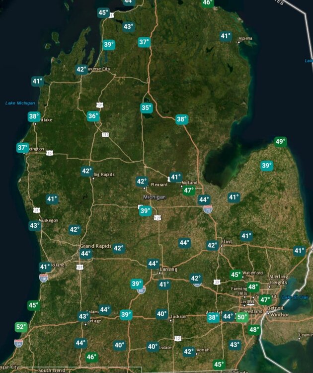
-

2025 Atlantic Hurricane Season
BarryStantonGBP replied to BarryStantonGBP's topic in Tropical Headquarters
-
2025-2026 ENSO
michsnowfreak replied to 40/70 Benchmark's topic in Weather Forecasting and Discussion
Detroit tied with 2 other years for 7th most days with mins of 70°+ (24) but tied with 10 other years for 44th most days of 90°+ (14). You can see it was the nights that did the lifting. -
BIG winter incoming.
-
 Torch Tiger changed their profile photo
 -
2025 Atlantic Hurricane Season
BarryStantonGBP replied to BarryStantonGBP's topic in Tropical Headquarters
-
Beautifully comfy day today. Did another evening walk outside and hardly broke a sweat…on Labor Day!
-

O'Brother Septorcher
Prismshine Productions replied to Prismshine Productions's topic in New England
Where can I check? Sent from my SM-S166V using Tapatalk
.thumb.png.4150b06c63a21f61052e47a612bf1818.png)


