All Activity
- Past hour
-
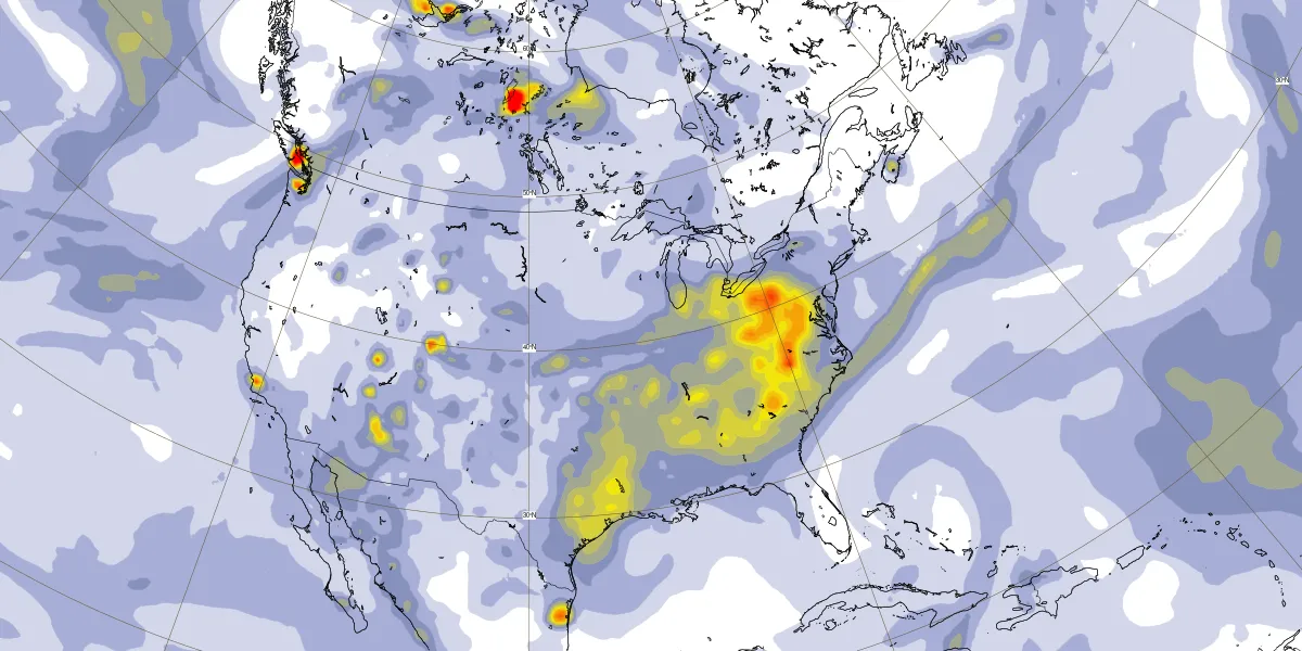
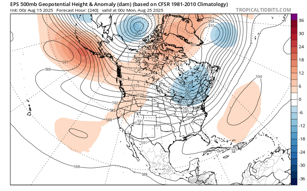
 Next week looks like what the surfers have been waiting for all summer. The best August hurricane swell that we have seen in years. The unusual part with the set up is how much smoke pools just to our SW as the Erin recurves OTS. So rather than much rain, we could see the smoke move into the area as Erin phases with the 50/50 low and another upper low from Hudson Bay heads for SE Canada. https://atmosphere.copernicus.eu/charts/packages/cams/products/aerosol-forecasts?base_time=202508150000&layer_name=composition_aod550&projection=classical_north_america&valid_time=202508200000

-
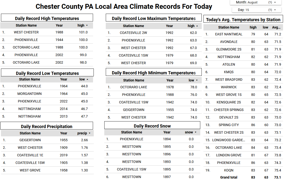
 If I go by Central Park's average for my location, which is probably more in line since its numbers are cooler overall than the more urban spots of the city, the closest ambient station to me is -3.5 degreess so far for the month.
 -
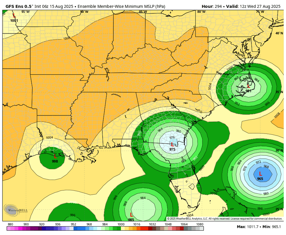
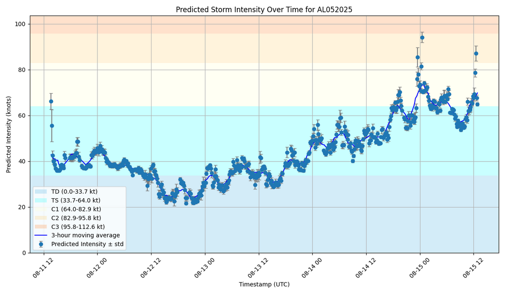
-Just for the record fwiw, the 6Z GFS hits Daytona on Aug 29 (way out at 2 weeks) -Much more statistically significant than just a fantasyland op run, its ensemble is unsettlingly pretty active in/near the SE US during Aug 26-30. Here’s a snapshot as of hour 294 (12Z on 8/27): -During this active period, GEFS has the MJO in/near phase 5. It’s not either of the 2 most active phases for H hits per day during Jul-Sep since 1975 (phases 2 and 8), but phase 5 has had the 3rd highest ratio of hits/day. - During phase 5, these 10 Hs hit the Conus: Francine (2024), Ike (2008), Humberto (2007), Ophelia (2005), Isabel (2003), Bertha (1996), Fran (1996), Bob (1991), Elena (1985), and Babe (1977). Two areas were most impacted by these 10: NC (Ophelia, Isabel, Bertha, Fran, and Bob) and upper TX to FL panhandle (Francine, Ike, Humberto, Elena, and Babe).
-
8" here over the same period. Feast or famine.
-
-
Lloyd Christmas likes it's chances
-
Not you lol.
-
 MMU: -3.1 TTN: -3 through the 14th PHL: -1.5
 -
I was just busting your balls But regarding your post, different stations already have their UHI level or general microclimate baked into their averages. Your -5 low might be 58 but my -5 low is more like 63 and LGA's -5 is 66. Many times that's where the difference lies, not that you or other places achieved a greater departure.
-
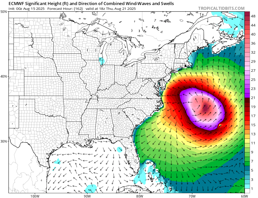
https://www.surfline.com/surf-report/rambler-road/5842041f4e65fad6a7708b60?referral=msw&view=table Various surf models with 5 to 10 foot waves on Thursday, as the peak day for swells from Erin. Stellar surfing day, but admit you got to be strong will to do so. For today across all beaches a low risk of ripe tides. For Saturday from Mount Holly For Saturday, northeast winds will be around 10 mph with breaking waves around 2 feet. There will be a light easterly swell with a period of 4 to 5 seconds. As a result, there is a LOW risk for the development of dangerous and life threatening rip currents at the Jersey Shore and at Delaware Beaches on Saturday.
-
 Not here. Early month I was in the low 50s for lows when you were 60+ and the cities were 65+. You can easily see from Bluewaves graphics. My highs are 0 to -2 and lows are -4 to -6.
 -
80/70 this morning. Been way worse than that the past weeks.
-
Its not set in stone
-
No need to worry about the snowstorms. They don’t happen anymore
-
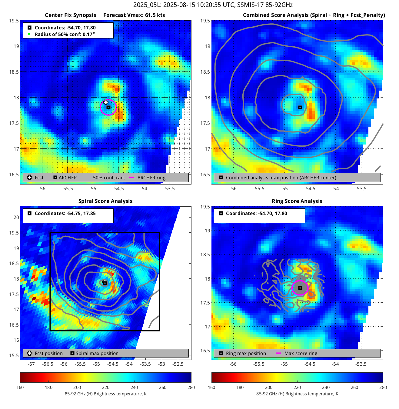
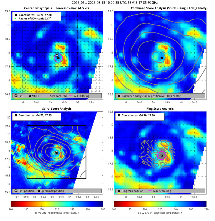
 Staff are working remotely in Ibiza and Napa then anyway BT has Erin at hurricane strength
 -
BAM BAM BAM THE WHOLE OF WETHERSPOONS IS SINGING FOR YOU LASS
-
 The NHC has not officially declared this a hurricane on its site.
 -
Whaddya mean "You people"?
-
Early next week the dewpoints will still be on the higher side due to the flow around Erin as it passes off the coast. Also depends on how close it tracks to the coast- Euro has it a bit closer. Mid to late week when winds shift to the N/NE on the backside drier air will work in. Looks like dewpoints may drop into the 50s to low 60s.
-
Dry so days not getting ruined and around -3 month to date here, I'll take it. Not much to complain about really minus watering a bit more. It has been beautiful. Beats the 16 consecutive weekends or so we had earlier this year that had rain. Some people are just never happy.
-
SCORE SOME FOOKEN GOALS LASS! CAM ON ERIN
-
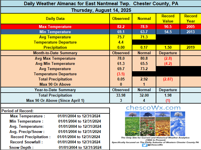
This weekend should feature above normal temperatures and still humid before we see a nice cool down to start the new work week and that should last through much of the new work week. Sunday looks like our last above normal temperature day for at least the next week or so. There are some rain and storm chances especially across Western Chester and SE Berks Counties later this afternoon into the evening. Otherwise dry through at least mid-week.
-

E PA/NJ/DE Summer 2025 Obs/Discussion
ChescoWx replied to Hurricane Agnes's topic in Philadelphia Region
This weekend should feature above normal temperatures and still humid before we see a nice cool down to start the new work week and that should last through much of the new work week. Sunday looks like our last above normal temperature day for at least the next week or so. There are some rain and storm chances especially across Western Chester and SE Berks Counties later this afternoon into the evening. Otherwise dry through at least mid-week.
-
 What a biting pattern but some nice coolers breaks….looks like another next week