All Activity
- Past hour
-
And you took this pic while riding a bicycle
-
Rush 'em in and rush 'em out. Except winter of course, unless it's too icy, too cold, or doesn't snow early or often enough.
-

2025 summer max contest -- enter by 06z June 23
WxUSAF replied to Roger Smith's topic in Mid Atlantic
DCA: 99 IAD: 97 BWI: 100 RIC: 99 -
I'm actually sort of intrigued at Sunday evening. The timing seems a bit off and it's not clear that areas (especially NE of the Potomac) will be unstable enough - but 12z NAM nest really fires a lot of storms mainly west and south of the metros. It would align well with CIPS honking - but not sure there's a ton of support. Good indication of missing ingredients.
-
I’m looking at my pics and videos of 1/6/25 and reminiscing already… definitely in my top ten all-time favorite snowstorms.
-
Exactly
-
I think we can agree that Summer's back is broken. Sure we may see a warm or even hot day here or there but soon we will be sipping hot fresh cider and peeping at leaves.
-
wow that sounds absolutely amazing, the smoke was your filter
-
There's some sort of cycle that sends storms here every 6-8 days or so. I wonder what it is.... This cycle won't be broken until we get a real dry spell, likely after June 20th.
-
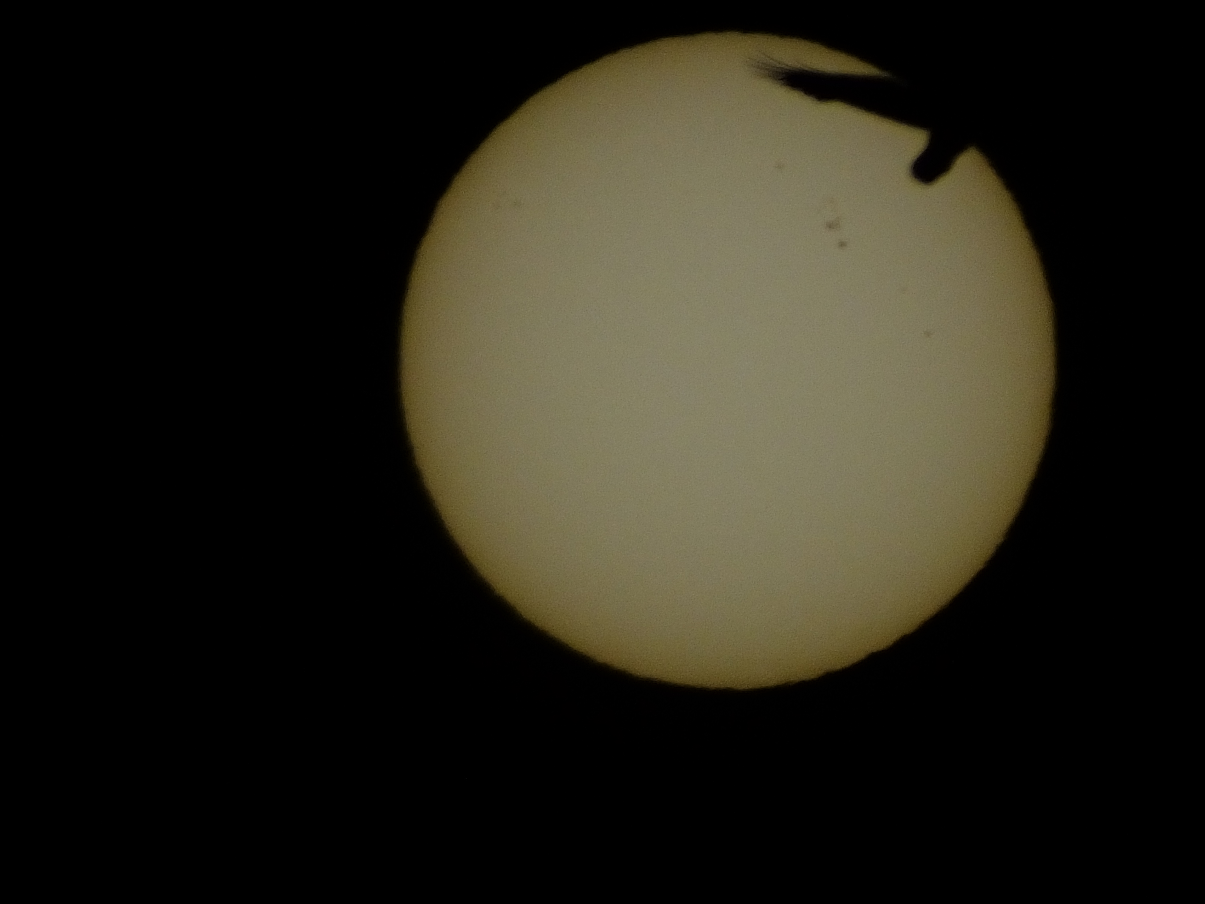
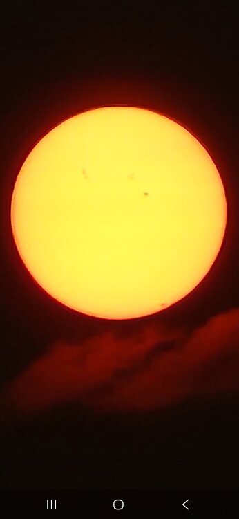
When we had the thicker smoke, I was able to catch the sunspots with my cell phone. That was pretty awesome.
-

2025 summer max contest -- enter by 06z June 23
PrinceFrederickWx replied to Roger Smith's topic in Mid Atlantic
DCA: 97 IAD: 96 BWI: 97 RIC: 97 -
Sunday looks to be dry but mostly cloudy. I don't think we're going to get an inch of rain out of this either.
-
lol, Looks like 70/50's for hi/lows up here next week.
-
Yeah I’d toss those GEFS temps… take +2 on most of that. So it’s normal to slightly AN… but it’s like Wiz said.. this is normal June. We like to rush seasons in.
-
i did not, but when i read the 5/28?? update, a footnote suggested that more area were likely to be reduced moving forward. My question was that we already had most of the rain in the bucket, and wasnt sure why the 5/28 map wasnt reflective of that. Again, that's showing the limits of what I know about drought/precip maps and the criteria used to make em. Thats all. Regarless, the map you posted is a much better looking one. Hoping further reductions are warrented, and not further increases. Been there...did that. Have a good one gang.
-
If we were in space, the sun would look nearly white (because evolution has determined that we see our sun as nearly white, as it is the primary source of light on our planet and our eyes use that to adjust color balance.) Life on exoplanets would most likely see their sun as white for the same reason (even though we might see their sun as orange or red.) By the way the reason that photosynthetic plants are green is because green has the highest efficiency rate of absorbing light from a yellow sun. On an exoplanet with what we perceive as a red sun, we would see photosynthetic plants as purple for the same reason our photosynthetic plants are perceived by us as green. The atmosphere always has an effect on the color of the sun, the particles suspended in it decide on how much. A lucky shot I took with a solar filter on one of my cameras to capture the sunspot maximum we had last year, caught a bird flying through the frame and eclipsing the sun (yes the sky darkened for a brief second as the bird flew by, just like it would during a real eclipse.) I have another shot somewhere where a plane flew right in front of the sun.

-
Hazy Hops and Hungover?
-
It's finally out! https://epawaweather.com/epawas-june-6th-long-range-forecast/
-
Know wheres near a HHH look on those maps.
-
models seem to be north this am with the best coverage. (Which is fine by me!)
-
I actually only looked at the EPS. And yeah, it's not a hot look, nor cool. It will lean a little AN I think...but we aren't getting big heat with a H5 ridge 1500 miles to the west.
-
TORCH!
-
Poughkeepsie too. I've noticed Poughkeepsie, Danbury and Scranton have all been hotter than us the last few years. So they beat us in snowfall in the winter and heat in the summer lol. Did you think it was curious that Montauk hit 80 degrees on a SW wind? I can understand how JFK hit 81 with only a short trajectory over water on a SW wind but how did Montauk hit 80 on such a wind?
-
The upcoming pattern isn't going to feature sustained heat/humidity. It is going to be an active patterns with fronts and shortwaves. With this, we'll get some hot/humid days mixed in, especially ahead of systems followed by a return to more seasonal conditions. Our perspectives of what should be happening are way out of whack. This looks like a much more typical stretch of weather for this time of year. We shouldn't be building in extended heat/humidity regimes early or mid-June. We should still be active with fronts and varying between a few days of heat/humidity followed by several days of seasonal weather. Building in extended heat/humidity shouldn't really happen until you move into and through July.
-
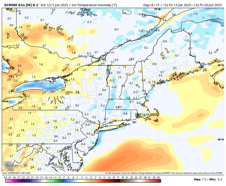
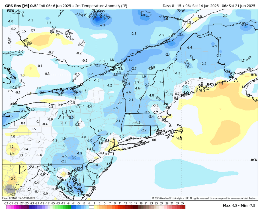
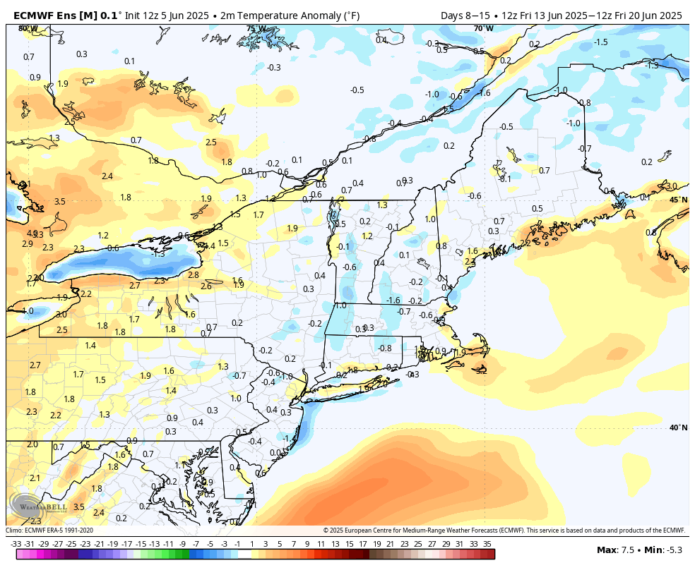
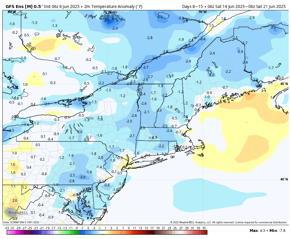
Have you looked? Because I honestly don't know if I believe you. I just did (because it's fairly easy to do so) and I'm seeing most ensembles are showing a normal temperature regime. GEFS are probably too cool, but I'm imagining that @CoastalWx also looked and arrived at his conclusion after seeing the H5 pattern and resulting set-ups. And I'm not calling for a cold pattern, before this gets spun as "some are calling for 40s and 50s". This is model data on a science forum. Read it how you want to. EPS Days 8 - 15 GEFS Days 8 - 15... this is colder.