All Activity
- Past hour
-
I was talking about the fact that repeating patterns have become more pronounced as the climate has warmed. While there was a weaker December to seasonal snowfall relationship prior to the 1990s, it has become more pronounced. My theory as to why this is that case is that we are seeing the beginnings of non-linear climate shifts. As convective thresholds begin to be crossed in tropical forcing regions with rapidly warming SSTs, it can be like flipping a switch where patterns start locking in more and become more persistent. Now the paper below is very technical, but in a tangential way to our discussion it’s the beginning of some new and potentially promising research. Circus Tents, Convective Thresholds, and the Non-Linear Climate Response to Tropical SSTs https://agupubs.onlinelibrary.wiley.com/doi/10.1029/2022GL101499
-

December 2025 regional war/obs/disco thread
40/70 Benchmark replied to Torch Tiger's topic in New England
I never said that I know some have...haven't looked too much yet. -

December 14th - Snow showers or Plowable snow?
TauntonBlizzard2013 replied to Sey-Mour Snow's topic in New England
NAM already looks worse to me through 22 -
Sure, but these “ice storm” ideas with +10C 850s are pretty farfetched too.
-
.thumb.png.4150b06c63a21f61052e47a612bf1818.png) Mom’s 90th birthday party got moved from Sunday to Saturday so that’s gonna make it a little tougher for me. I’ll see if I can get there around 5-6pm.
Mom’s 90th birthday party got moved from Sunday to Saturday so that’s gonna make it a little tougher for me. I’ll see if I can get there around 5-6pm. -
I think field will be ok by 1. They’re gonna try and throw I bet.
-

Minor snow possible sunday 12/14/25
BoulderWX replied to WeatherGeek2025's topic in New York City Metro
Looks very reasonable - the rest is just noise! -
December 2025 regional war/obs/disco thread
40/70 Benchmark replied to Torch Tiger's topic in New England
Yea, just because on a larger scale the pattern is mild doesn't necessarily mean it translates to ubiquitous warmth at the surface....especially near the winter solstice. -
Big fire a few homes up from me this morning. Not sure how many “alarms” it was, but I saw a Laconia truck there too. Looks like 2 people and 2 dogs displaced…tough time with the cold and holiday season. Awful.
-

December 2025 regional war/obs/disco thread
weatherwiz replied to Torch Tiger's topic in New England
I'm sure there will be a passing game for just snow showers -
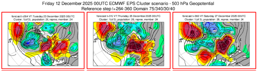
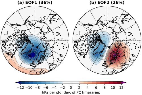
Hmm, this is an interesting chart depicted by last night's eps cluster analysis. Not for whatever it may be depicting in anyone's backyard. The leading cluster in the day 11-15 range is this one. That progression of the troposphere gets really close to something resembling EOF2 from the following paper. With the +NAO and Scandinavian block. The typical progression leading to it is even pretty close to what is depicted in the paper. The Scandinavian Greenland dipole. Worth keeping an eye out for that phenomenon in future runs. As it's not something that's well modeled in advance. But a depiction of something like that on a prominent piece of guidance is interesting. Representation of the Scandinavia–Greenland pattern and its relationship with the polar vortex in S2S forecast models https://rmets.onlinelibrary.wiley.com/doi/full/10.1002/qj.3892 From the abstract: "The strength of the stratospheric polar vortex is a key contributor to subseasonal prediction during boreal winter. Anomalously weak polar vortex events can be induced by enhanced vertically propagating Rossby waves from the troposphere, driven by blocking and wave breaking. Here, we analyse a tropospheric pattern—the Scandinavia–Greenland (S–G) pattern—associated with both processes. The S–G pattern is defined as the second empirical orthogonal function (EOF) of mean sea-level pressure in the northeast Atlantic. The first EOF is a zonal pattern resembling the North Atlantic Oscillation. We show that the S–G pattern is associated with a transient amplification of planetary wavenumber 2 and meridional eddy heat flux, followed by the onset of a weakened polar vortex, which persists for the next two months."
-
Fantasy playoff semifinals for me. I have to choose between Maye (snow/Buf) and Lamar (injury). I feel like Vrabel would be ground and pound with snow.
-

December 14th - Snow showers or Plowable snow?
CoastalWx replied to Sey-Mour Snow's topic in New England
Prepare for an interception. -
If it makes you feel any better Euro AI sides with the gfs. I’m always intrigued my Christmas day weather, but we’re still a good 5-7 days away from having a clue.
-

12/14: Sunday funday? Will the south win again?
NorthArlington101 replied to TSSN+'s topic in Mid Atlantic
48hr HRRR owes me an inch for today still. Always prefer to have every piece of guidance snow on me but I'm okay losing this one. I'll hug the 12k NAM, which promised @Bob Chill 4" of snow today at 12z yesterday. I'm sure that's panned out well. -
December 14th - Snow showers or Plowable snow?
CoastalWx replied to Sey-Mour Snow's topic in New England
HRRR says to enjoy my coating. -

December 14th - Snow showers or Plowable snow?
WinterWolf replied to Sey-Mour Snow's topic in New England
That’s the spirit. -
December Medium/Long Range Discussion
Siberian-Snowcover-Myth replied to yoda's topic in Mid Atlantic
The upcoming Xmas Warmth is reminiscent of December 2015. 70degree temps in central Va for numerous days. Dominant WAR….Then the following month January 23rd, we received 18” from Winter Storm “Jonas”. So there’s always hope! -
I fondly remember the 1-2” the hrrr 48 hours ago said I was getting today
-
Well hopefully snow otg. Might be a lot of sublimating half inch deals too.
-

December 2025 regional war/obs/disco thread
Ginx snewx replied to Torch Tiger's topic in New England
Monday is going to be deep deep winter with snow otg and wind chills below zero -
If that does happen, congrats. You deserve your snow, and since it won't affect school too much, I wouldn't even be salty.
-

December 11th - 12th clipper potential
Daniel Boone replied to Holston_River_Rambler's topic in Tennessee Valley
Does anyone know why the board is not allowing me to post Pictures. It says only allows 121 kb size. I can't get them that small without cutting most of pic away and very small. -

Central PA Winter 25/26 Discussion and Obs
pasnownut replied to MAG5035's topic in Upstate New York/Pennsylvania
You are far from alone. Specially in this forum. lol. We r Sno hounds to our very core. I’m very happy with the start of winter here and warmups are part of the game. No biggie. I’m in the Sno covered crunchy ass woods of southern Lebanon county right now and can tell you it looks and feels like mid winter here. Deers winnin with the noise I’m making while scaling the ridges. -

12/14: Sunday funday? Will the south win again?
dailylurker replied to TSSN+'s topic in Mid Atlantic
Hrrr basically just canceled the event for everyone outside extreme NE MD. Notice how heat never gets canceled? Lol


