All Activity
- Past hour
-
Looks good but had to edit it a bit.

-
Not sure anyone saw this but Josh Timlin put together a great page which aggregates all kinds of cool weather maps and data: https://contextclimate.io/#/
-
Got about .25 knocked down the pollen some. But there's plenty more coming off the trees.
-
Correct. Yesterday was glorious. 1st good Saturday weather of year for golf.
-

2026-2027 Super El Nino
bluewave replied to Stormchaserchuck1's topic in Weather Forecasting and Discussion
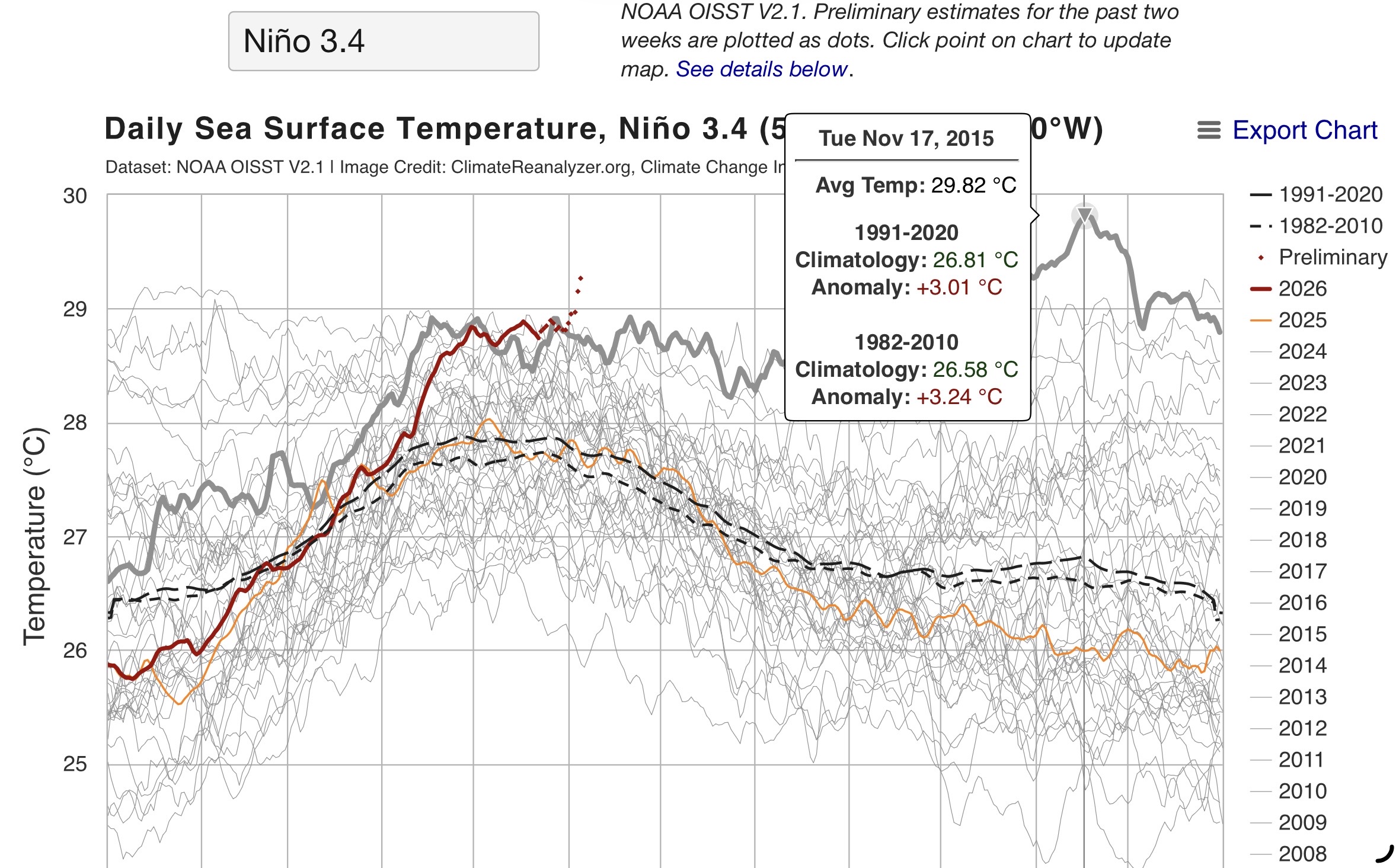
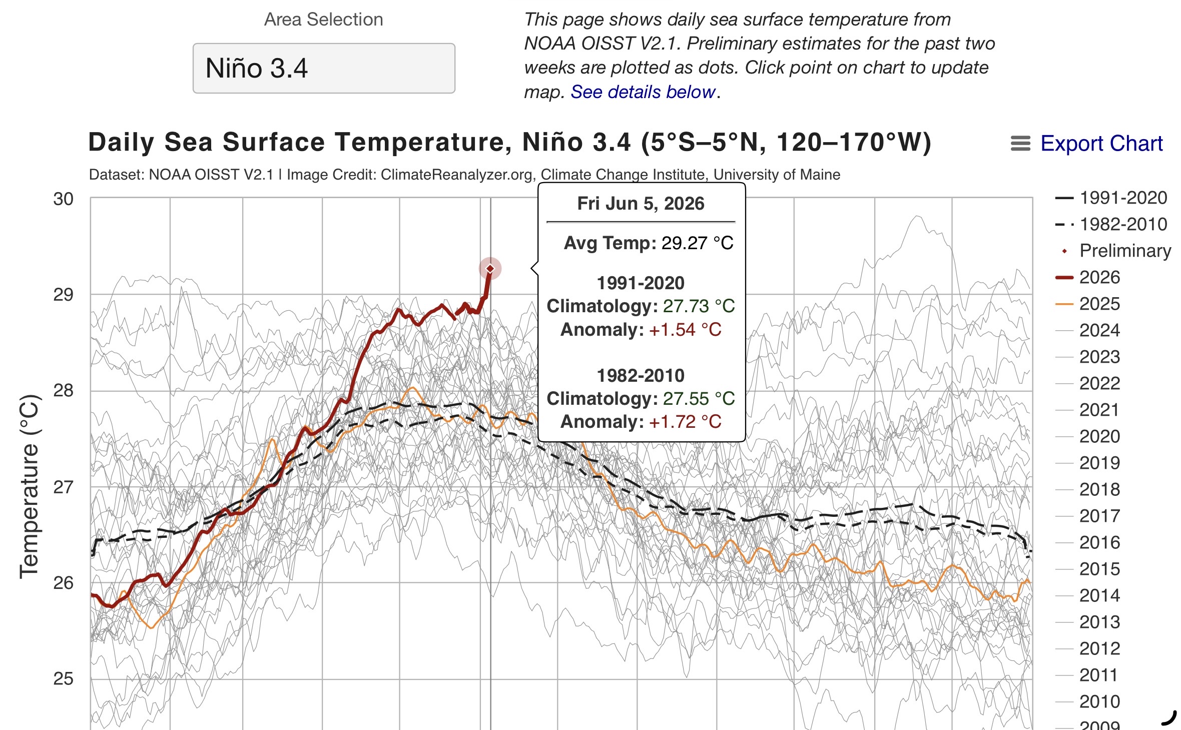
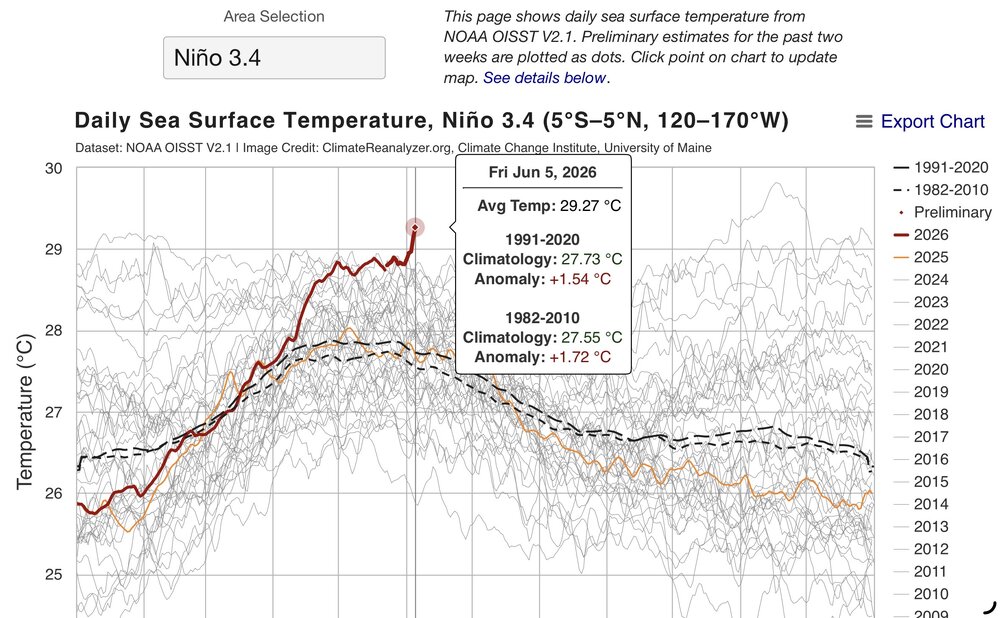
Nino 3.4 getting to 29.27 is really impressive so early in this event. The all-time record was 29.82 back on 11-17-15. They may need to extend the scale since the current forecast peak over is 30°C.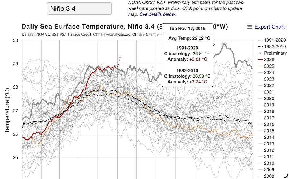
-
Bridgeport: 5 days, 1957, 1984 Islip: 6 days, 1987 New York City-Central Park: 10 days, 1925, 1991 New York City-JFK Airport: 5 days, 1962, 1984, 1988, 1991 New York City-LaGuardia Airport: 9 days, 1991 Newark: 13 days, 1991 White Plains: 5 days, 1957, 1984
-
Id expect storms chances much the coming heatwave this week but brunt of the heaviest rains/storms are in the midsection and S-Fl
-
Records: Highs: EWR: 99 (1999) NYC: 96 (1925) 94 in 1999 * / 2008 LGA: 97 (1999) JFK: 92 (1999) Lows: EWR: 48 (1945) NYC: 47 (1879) LGA: 50 (2000) JFK: 50 (2000) Historical: 1816 - A famous June snow occurred in the northeastern U.S. Danville VT reported drifts of snow and sleet twenty inches deep. The Highlands were white all day, and flurries were observed as far south as Boston MA. (David Ludlum) 1816: FAMOUS JUNE SNOWSTORM; "YEAR WITHOUT A SUMMER" -- 20 inch snowdrifts in Danville, VT flurries in Salem and Boston, MA A famous June snow occurred in the northeastern U.S. Danville, VT reported drifts of snow and sleet twenty inches deep. The Highlands were white all day, and flurries were observed as far south as Boston, MA.(David Ludlum) Upstate, NY received 3 inches of snow (p.33 Washington Weather Book 2002 by Ambrose, Henry, Weiss) 1816: The following is found on page 31, from the book, "History of the American Clock Business for the Past Sixty Year, and Life of Chauncey Jerome," written by Chauncey Jerome. The book was published in 1860. "The next summer was a cold one of 1816, which none of the old people will ever forget, and which many of the young have heard a great deal about. There was ice and snow in every month of the year. I well remember on the seventh of June, while on my way to work, about a mile from home, dressed throughout with thick woolen clothes and an overcoat on, my hands got so cold that I was obliged to lay down my tools and put on a pair of mittens which I had in my pocket. It snowed about an hour that day." This bitter cold event occurred in Plymouth, Connecticut. 1885: A severe thunderstorm dropped hail up to 4 inches in diameter and spawned a tornado at Parkhill St.Thomas, Ontario Canada. Homes and orchards were damaged.(Ref. Wilson Wx. History) 1907: A violent tornado moved across Washington County, from near Covington to New Minden, IL. Near the tornado's endpoint, 4 people were killed while running to their storm cellar. Another violent tornado in southern Clark County destroyed or damaged every building in Old York. The tornado tracked for 15 miles, crossing into Indiana. (Ref. Wilson Wx. History) 1908: An F3 tornado touched down in Hillsboro, WI and then moved northeast to just southeast of Mauston, WI. About 4 miles south of Mauston, the tornado killed a farmer and his son as they ran for their storm cellar. Another F3 tornado tracked northeast from 9 miles northwest of Charles City, IA to two miles northeast of Charles City. It left only the floor boards on a small farm house about 5 miles northwest of Charles City. In the east part of Charles City, 5 homes were destroyed and 20 others were severely damaged. A man was killed by a falling chimney and 10 others were injured. About 200 buildings were damaged. (Ref. Wilson Wx. History) 1953: An F4 tornado near Arcadia, NE killed 11 people, beginning a 3-day stretch of killer tornadoes that spread into the eastern U.S. Scottsbluff, NE received its greatest daily precipitation on record when 3.18 inches of rain deluged the city. (Ref. Wilson Wx. History) 1972 - Richmond VA experienced its worst flood of record as rains from Hurricane Agnes pushed the water level at the city locks to a height of 36.5 feet, easily topping the previous record of thirty feet set in 1771. (The Weather Channel) 1980: Thunderstorms caused downed trees and power lines as well as street flooding all across western New York State. A wind gust of 79 mph was observed at greater Buffalo International Airport. Golf ball sized hail was reported north and east of the city. A rare flash of St. Elmo's fire knocked out the Weather Service's radar and telephone lines for about 10 minutes as the storm passed. Air controllers at the Buffalo Airport said the control tower received a direct lightning strike that blackened out the air control computer for a short period. (Ref. Wilson Wx. History) 1983: Miami, FL dropped to an overnight low temperature of 80° which set a new record for the highest minimum temperature at that location.(Ref. Wilson Wx. History) 1984: 42 tornadoes touched down in the Upper Midwest with 21 of them occurring in Iowa. An F4 tornado tracked 30 miles through Mahaska and Keokuk Counties in Iowa, killing two people and injuring 51 others. The small town of Wright was practically wiped out. Barneveld, WI was devastated shortly before midnight as an F5 tornado chewed up the town. 90% of the town was damaged or destroyed, nine people were killed, and 197 were injured. (Ref. Wilson Wx. History) 1987 - Thunderstorms in the Laramie Mountains of eastern Wyoming produced golf ball size hail, and up to five inches of rain in just one hour. Half a dozen cities in the Upper Mississippi Valley reported record high temperatures for the date, including La Crosse, WI, with a reading of 97 degrees. (The National Weather Summary)(Storm Data) 1988 - Snow whitened some of the mountains of northern California and northwestern Nevada. Twenty-six cities in the central and eastern U.S. reported record high temperatures for the date, including Rapid City SD with a reading of 104 degrees, and Miles City, MT, with a high of 106 degrees. (The National Weather Summary) 1989 - Thunderstorms produced severe weather from southern Oklahoma and eastern Texas to northwestern Florida through the day and night. Thunderstorms spawned 22 tornadoes, including a dozen in Louisiana, and there were 119 reports of large hail and damaging winds. A strong (F-2) tornado at Gross Tete LA killed two persons, injured thirty others, and another strong (F-2) tornado injured 60 persons at Lobdell LA. Softball size hail was reported at Hillsboro TX. (The National Weather Summary) (Storm Data) 1993: Thunderstorms erupted over western Iowa, with many producing hail. Damage at one car dealership in Carroll was estimated at $250,000 dollars and another at Estherville had $100,000 dollars in damage. At Arnolds Park, 65 mph winds lifted boats from their moorings. The strongest tornado was in Lyon and Osceola Counties where it was on the ground for 10 miles. In Sibley, IA one roof was taken off of a house and a high school bus barn was severely damaged causing about $150,000 dollars in damage. A huge tornado touched down in northwest Minnehaha County in South Dakota and cut a swath of destruction 55 miles long and one half mile wide. Most structures within the path of the tornado were little match for the storm which packed winds estimated between 210 and 260 mph. Numerous farms and residences were destroyed and trees snapped off or uprooted. Parts of the Chicago, IL metropolitan area were flooded after thunderstorms produced 2 to 5 inches of rain in a 3-hour period. This type of a rainstorm in that area has an average occurrence rate of once every 30-60 years. Over the period of a day, up to 6.50 inches of rain fell, producing one of greater floods noted in that area. The deep tunnel flood control system under the south side of Chicago which holds 185 million gallons of water was filled. (Ref. Wilson Wx. History) 1995: An F2 tornado hit a pickup near Wilsey, KS: the driver was thrown into a nearby ditch. Although barbed wire/clothing were wrapped around his legs/body, he survived. The truck was carried ¼ mile; the engine another 200 yards from the destroyed truck chassis. (Ref. Weather Guide Calendar with Phenomenal Weather Events 2011 Accord Pub. 2010, USA) 2008: On this date through the 9th, New York City set record high temperatures for three days: 96°, 96° and 99° respectively. A single supercell thunderstorm developed over western Illinois and moved east to the Indiana border, producing 8 different tornadoes along its path, including some of the southern Chicago suburbs. Four of the tornadoes were rated EF2 in strength. (Ref. Wilson Wx. History)
-

2026-2027 Super El Nino
snowman19 replied to Stormchaserchuck1's topic in Weather Forecasting and Discussion
The thermocline is about to deepen (drop) big time in the eastern tropical PAC. This very strongly supports this event staying east-based/East Pacific -
finally some action soon
-
77 / 68 sunny. Warm but about 7 - 9 degrees cooler than yesterday for most. Onshore flow Mon - Tue drops it back cooler upper 70s to low 80s. Wed moderating warmer. Looks like a classic Hazy - Hot - Humid and potential for daily tstorms Thu - Sun, temps could push record levels in areas. Beyond there some moderation but overall wamer with bouts of heat with ridge on both coastal corners and likely storm chances. 6/7 - 6/9 : Near normal cooler Monday 6/10 -6/14 : Hot , Storms peak heat Thu - Sun 6/15 - beyond : Overall warmer - storms chances
-
Are you the same guy that has been complaining about not being able to get your Saturday game in without being rained on?
-
2026-2027 Super El Nino
snowman19 replied to Stormchaserchuck1's topic in Weather Forecasting and Discussion
“No surprises in the latest NMME climate model output. Niño intensity has ticked up in a few of the models (the CanESM5 was one of the last moderate Niño holdouts last month but it's all in on a near-record event now). I think the NCAR CESM1 broke or something this month. The response looks extremely classic too. Wet anomalies across the tropical Pacific, with the NE and Central Pacific also active thanks to the +PMM. The Atlantic will be dry and hostile for basically the whole season, with drought possible in the Caribbean. The Gulf Coast will likely have a wet and stormy winter as the subtropical jet gets cranking.” -
Pollen is so bad. About to hose off my truck, porch, driveway and kids swing
-
Thanks. The 0Z EPS cut back significantly on the % of members with Gulf TCG vs yesterday’s 12Z run. It will be interesting to see how future runs compare. The 6Z GEFS has significantly increased activity vs earlier runs.
-
Yeah the wind really picked up in the last half hour. 69/60 Feels chilly!
-
Today's update cut back those numbers quite a bit.
-
Yesterday’s 12Z EPS had nearly 50% of its members with a TCG in S Gulf/NW Car late next week with most of those then heading to the U.S. Gulf coast the following week. However, the 0Z EPS cut back significantly on the % of members with Gulf TCG vs yesterday’s 12Z run. It will be interesting to see how future runs compare. The 6Z GEFS has significantly increased activity vs earlier runs.
-
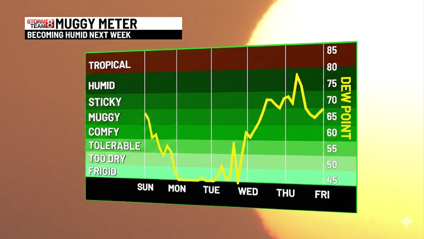
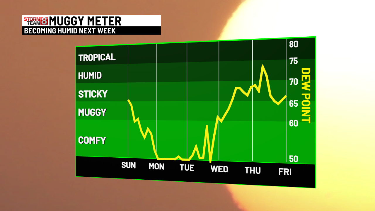
Dewlicious
-
We retreated to coast and it’s been beautiful here all weekend. Sea breeze and 80
-
.6
-
Let's not forget about the dews...

-
Days and days of 90s coming up. Cant wait.
- Today
-
It lasts a few days. Summer is the best season. Winter is slowly dying. We summer. We hop on the bandwagon.
-
Wind? Some big boomers down there.