All Activity
- Past hour
-

Minor snow possible sunday 12/14/25
ILoveWinter replied to WeatherGeek2025's topic in New York City Metro
I live in the UWS and there were a few events which I measured at or above 4 inches in the past several years. They just don't know how to measure. -

December 2025 regional war/obs/disco thread
Sey-Mour Snow replied to Torch Tiger's topic in New England
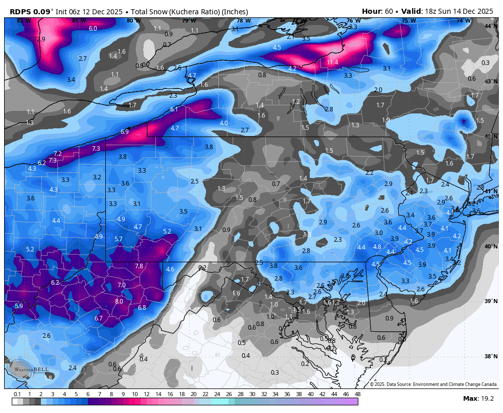
that's warning snow on south coast verbatim , I'm just going to make pretend All other guidance is like .1 to .2" qpf while euro is double that .. With ratios thats the difference between a fluffy 1-3" on most guidance .. While euro is widespread 2-4" up to 6" with the ratios in southern CT.. I'd assume there'd be a few hours of a legit band with that look.. But 6z EURO is tossed until it gets support -
White Christmas?
-

Minor snow possible sunday 12/14/25
EastonSN+ replied to WeatherGeek2025's topic in New York City Metro
Central Park record may still stand which is incredible given literally all other areas have had a 4 inch snowfall in that time frame lol. -
-
No need to show your age!
-

Minor snow possible sunday 12/14/25
MJO812 replied to WeatherGeek2025's topic in New York City Metro

-
Double EE rule and let it ride
-

December 2025 regional war/obs/disco thread
Ginx snewx replied to Torch Tiger's topic in New England
Its only a couple of tenths I mean why not. Let's ratio the shit out of this POS -
December 2025 regional war/obs/disco thread
Ginx snewx replied to Torch Tiger's topic in New England
Merry Christmas you old GRINCH.thumb.png.32537ca5e08da280a999d336f7e95b51.png)
-
December 2025 regional war/obs/disco thread
Sey-Mour Snow replied to Torch Tiger's topic in New England
It's ridiculous, best euro run in several cycles , we just got euro 6zd - it's equivalent to the nam extra 33% qpf theory -
There's my inch or 2.
.thumb.png.f32eb4317646ae0da24af596e4683f44.png)
-
Minor snow possible sunday 12/14/25
MJO812 replied to WeatherGeek2025's topic in New York City Metro
Gfs is still in its own world. Even the AI gfs is with the other models. -
Minor snow possible sunday 12/14/25
MJO812 replied to WeatherGeek2025's topic in New York City Metro
AI Euro and Euro give NYC 2-4 inches. Nice little bump up. -

December 11th-14th Double Banger Clippers
Chicago WX replied to Jackstraw's topic in Lakes/Ohio Valley
1.0" of pure fluff here overnight. Where did that come from? Hopefully we can pull something out of thin air again tomorrow. 1-2" is probably the top end, but with temps in the single digits, well, arctic appeal for sure. -

Central PA Winter 25/26 Discussion and Obs
Blizzard of 93 replied to MAG5035's topic in Upstate New York/Pennsylvania
The 6z RGEM brings a widespread 1 to 3 to 3 to the LSV.
-
Change the track man. Put that needle in another groove.
-

Minor snow possible sunday 12/14/25
North and West replied to WeatherGeek2025's topic in New York City Metro
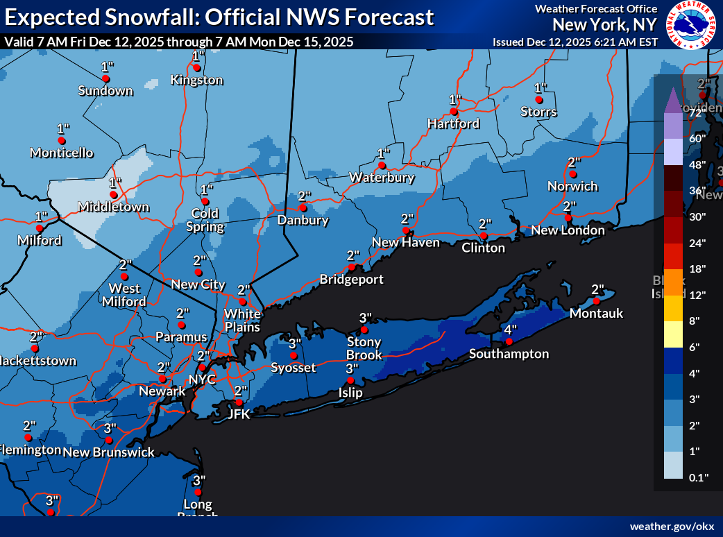
35% seems too generous. . -
Central PA Winter 25/26 Discussion and Obs
Blizzard of 93 replied to MAG5035's topic in Upstate New York/Pennsylvania
CTP point & click for Harrisburg: Saturday Night Snow showers. Low around 24. Northwest wind 3 to 6 mph. Chance of precipitation is 80%. New snow accumulation of 1 to 2 inches possible. -
Minor snow possible sunday 12/14/25
North and West replied to WeatherGeek2025's topic in New York City Metro
Be happy? . -
Lol 06z euro trying to suck us back in.
-
December 2025 regional war/obs/disco thread
Sey-Mour Snow replied to Torch Tiger's topic in New England
Who's shocked the 6z euro is great again.. not me .. think we can just toss all 6z and 18z euro guidance.. it's a joke -

12/14: Sunday funday? Will the south win again?
Stormchaserchuck1 replied to TSSN+'s topic in Mid Atlantic
I don't think there's any model showing 4" right now. -

2025-2026 ENSO
donsutherland1 replied to 40/70 Benchmark's topic in Weather Forecasting and Discussion
It should be abundantly clear now that the plausible scenario of a warmup within a few days of December 20 has become the baseline scenario. The weakening WPO- regime coupled with unfavorable teleconnections will allow for most of the CONUS to see temperatures move above normal. The ongoing warmth will continue in the West, as well. It is also increasingly clear that the PNA will wind up predominantly negative this month. Most of Canada should remain cold beyond December 20, however eastern Canada, including Ontario and Quebec could begin to warm up several days later. -

Central PA Winter 25/26 Discussion and Obs
mahantango#1 replied to MAG5035's topic in Upstate New York/Pennsylvania
Just how long and strong will this advertised warm up last? Will it get cut off at the pass or will we all enjoy warmer weather? Does this also mean there won't be any frozen precipitation events either?


.png.cc186550816389c6adb7f88d0e88137a.png)

.png.f812ee8ea6ef4bbfce823f259d668516.png)