All Activity
- Past hour
-
Ok.
-

December 2025 regional war/obs/disco thread
40/70 Benchmark replied to Torch Tiger's topic in New England
Shocking it would favor that corridor. -
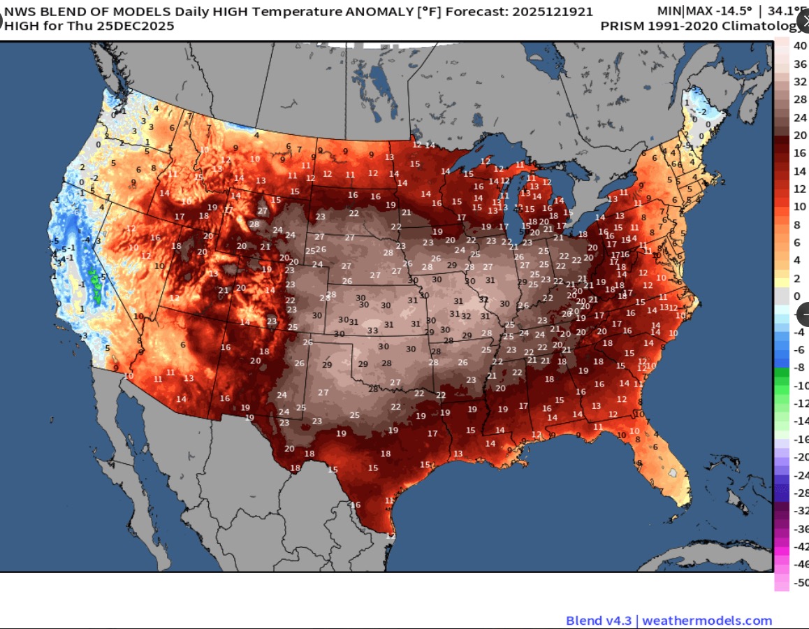
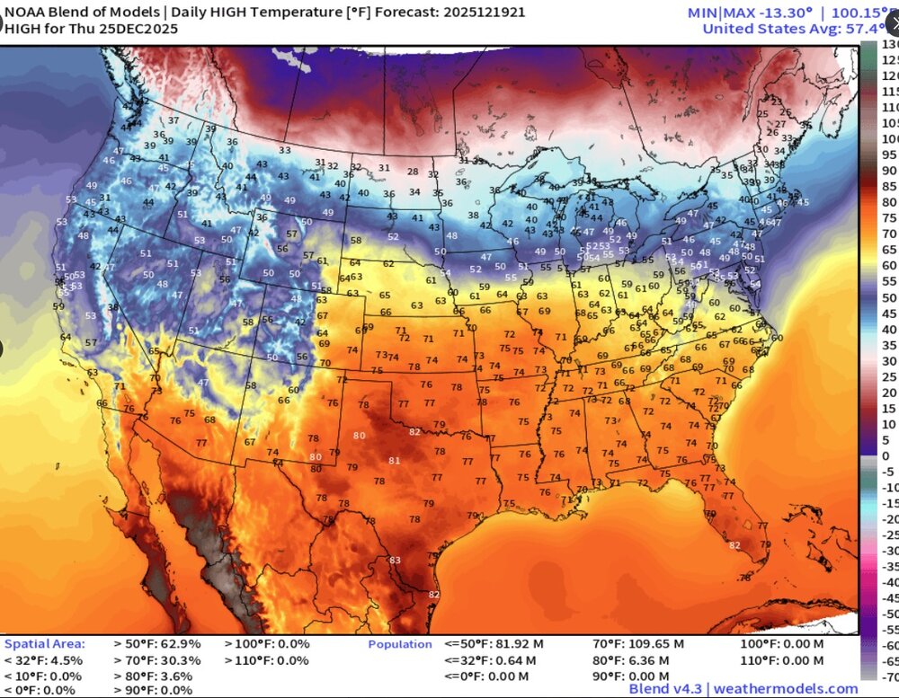
Cooler air is now pouring into the region. The weekend will turn somewhat cooler. No exceptionally cold or warm weather appears likely for the first week of astronomical winter. In terms of precipitation, some rain or snow showers are possible on Tuesday. The closing week of December could experience periodic warmer and cooler days. It now appears that the cooler anomalies will persist mainly in central and northern New England. The probability that December 2025 will have a maximum monthly temperature below 60° has continued to increase. The last time that happened was in 2019 when the monthly high was 58°. If 2025 has a monthly high below 60°, that would be only the fifth such occurrence since 2000 (2003, 2004, 2005, and 2019 are the cases since 2000). The ENSO Region 1+2 anomaly was -0.3°C and the Region 3.4 anomaly was -0.7°C for the week centered around December 10. For the past six weeks, the ENSO Region 1+2 anomaly has averaged -0.33°C and the ENSO Region 3.4 anomaly has averaged -0.67°C. La Niña conditions will likely continue through at least mid-winter. The SOI was -1.19 today. The preliminary Arctic Oscillation (AO) was +2.327 today. Based on sensitivity analysis applied to the latest guidance, there is an implied near 98% probability that New York City will have a cooler than normal December (1991-2020 normal). December will likely finish with a mean temperature near 34.3° (4.8° below normal). Supplemental Information: The projected mean would be 3.1° below the 1981-2010 normal monthly value.
-
Nice late December mcs rolling thru
-

December 2025 regional war/obs/disco thread
Damage In Tolland replied to Torch Tiger's topic in New England
Slowly correcting colder -
Mehthuen
-
Some flakes mixing in but this will be too little too late for anymore
-

December 2025 Short/Medium Range Forecast Thread
Golf757075 replied to John1122's topic in Tennessee Valley
Maybe you can post the euro ext mean on snow, if available. -
Euro looked ok for the 23.
-

Central PA Winter 25/26 Discussion and Obs
canderson replied to MAG5035's topic in Upstate New York/Pennsylvania
Winds had been down in the upper 30s for a bit but are back to mid 50s the last 15 or so mins. Should last that strong for hours. Good times. -
Sure looks like a deal from a front office that knows they have a few year window left to capitalize. I like it.
-

December 2025 regional war/obs/disco thread
powderfreak replied to Torch Tiger's topic in New England
Tuesday into Wednesday could be a nice refresh. Euro has liked WxWatcher to here to you.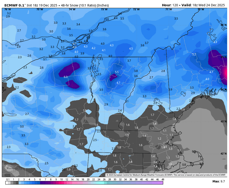
-

December 2025 regional war/obs/disco thread
TauntonBlizzard2013 replied to Torch Tiger's topic in New England
The always frigid OBX high pressure. Our biggest snows come from those -
I’m in Bretton Woods. I mean, it may be a disaster but there’s more snow on the ground than last year at this point with more on the way. At least here and we usually bear the brunt of cutters compared to low lying areas. Haven’t really looked at Tuesday and honestly I doubt anyone really knows. Still 4 days away! All I’d say is - there will be a bit more snow than now
-

Central PA Winter 25/26 Discussion and Obs
Blizzard of 93 replied to MAG5035's topic in Upstate New York/Pennsylvania
Wild weather day! Heavy rain, followed by 2 hours of relatively warm sunshine, then more heavy rain & wind. Then, Snow showers when leaving my office in Harrisburg & snow showers in Marysville with a light dusting on car tops. -

December 2025 Short/Medium Range Forecast Thread
Holston_River_Rambler replied to John1122's topic in Tennessee Valley
Someone posted on southernwx that the extended Euro control showed a pretty good way out of this mess. I see Golfman posted the snow map above, I can throw up some gifs of the 500mb anomalies and MSLPs if there is interest. -
Nice Video! Thanks for sharing.
-
Rotting block and improving PAC hopefully by then so maybe something.
-
Colin ? Noreaster?
-
Seems like there was a good core of wind that went from SE CT NE to RI and metro west, just west of that rain band to the east. Probably drier air helping to mix a bit. While east had similar winds, they had a stronger LLJ. However I think the rain helped keep things below 70 which would have been attainable.
-
Hideous.

-
Central PA Winter 25/26 Discussion and Obs
canderson replied to MAG5035's topic in Upstate New York/Pennsylvania
If anyone sees three of my downspout extenders I’d love to have them back. Same goes for the Christmas tree that was at the broad street market. It got blown somewhere. -
Bah... my damage report hasn't made the LSR yet.
-
December 2025 regional war/obs/disco thread
40/70 Benchmark replied to Torch Tiger's topic in New England
Guy I talk shop with online is whispering about a big coastal between Jan 8-12. -
Any wind with it?