All Activity
- Past hour
-

Central PA Spring 2025
Itstrainingtime replied to canderson's topic in Upstate New York/Pennsylvania
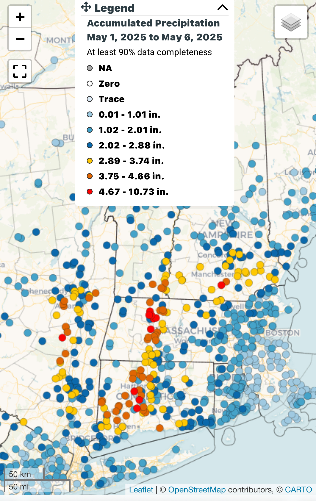
No rain in Maytown in 49 hours - this map is overdone for my area but I guess gives a decent idea of what's happening: -
Incredible. I got .02” overnight.
-
Event is 1.66” Day currently at .34” Month is currently 2.84" Had to run my oldest to a film set this morning and there was some low lying fog/mist in the neighborhood.
-
1.3" since Saturday.
-
Downpour now. Won't last long but it's all adding up
-
Ya for you guys out East for sure.. Still a solid 2-5" in these parts since Midnight Monday..
-
Darn. I was hoping you had a model that didn’t show a coastal storm ruining Saturday.
-
Oh sorry haha. I meant last weekend.
-
Don’t really see big heat either. Bit with that cutoff to our south next week.
-
This coming weekend?!?
-
Radar kinda looks like another long slug is gonna move S to N through the city/western LI and up east of the River.
-
I’ll take the dry weather we had though. What a weekend starting Friday.
-
I meant post Sunday. Way too wet.
-
I let the pros grow veggies (read I buy them from organic grocery stores), but I do grow flowers and mine look like pancakes from this excessive rainfall. The first thing I would do with weather modification is put an end to cutoff lows. Showers and Tstorms that come at night after a sunny hot day are fine, not days and days of this Ireland weather crap. I'd like to know why cutoff lows are on the increase and especially in May, when they never used to happen this late in the season back in the 80s and 90s.
-
we're going to have so much mold and fungus from this
-
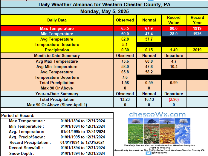
Another 0.56" of rain yesterday brings me up to 1.32" for the event and 1.33" for the month of May so far.
-
Lots of flooding potential into the South
-
Euro still not updating into EWALL but similar with cutoff underneath the ridging potential next week.
-
Records: Highs: EWR: 93 (1949) NYC: 92 (1986) LGA: 93 (1949) JFK: 88 (1986) Lows: EWR: 40 (1967) NYC: 32 (1891) LGA: 41 (1967) JFK: 37 (1992) Historical: 1876: A tornado, estimated at F3 intensity, tracked four miles across Chicago, Illinois. The damaged buildings included a candy factory, a hospital, a freight depot, and a church. The tornado moved out over Lake Michigan and was observed to have multiple vortices by a reporter. Further south in Illinois, a tornado blew a moving passenger train off the tracks near Neoga, injuring all 19 people aboard. 1911 : Record Minimum temperature for Washington, DC for the date is 37 °F. 1917: Amarillo, TX had its latest snowfall on record with 9.1 inches falling. 1933 - Charleston, SC, was deluged with 10.57 inches of rain, an all- time 24 hour record for that location. (The Weather Channel) 1937: The German passenger airship LZ 129 Hindenburg caught fire and was destroyed during its attempt to dock with its mooring mast at Naval Air Station Lakehurst in Manchester Township, New Jersey, United States. Of the 97 people on board (36 passengers and 61 crewmen), there were 35 fatalities (13 passengers and 22 crewmen). One worker on the ground was also killed, making a total of 36 deaths. The Hindenburg was delayed two hours from docking due to thunderstorms in the area. 1975 - A massive tornado hit Omaha, NE, killing three persons, injuring 133 others, and causing 150 million dollars damage. The tornado struck during the late afternoon moving northeastward through the industrial and residential areas of west central Omaha, and lifting over the northern section of the city. The twister, which cut a swath ten miles long and as much as a quarter of a mile wide, was the mostly costly in U.S. history up til that time. (David Ludlum) 1987 - Eighteen cities in California and Oregon reported record high temperatures for the date. Highs of 91 degrees at Portland OR, 101 degrees at Medford OR, and 104 degrees at Sacramento CA, were the warmest of record for so early in the season. (The National Weather Summary) 1988 - A major storm brought high winds to the western half of the country. A wind gust of 74 mph at Pueblo CO broke their May record established just four days earlier, and winds in the Arapahoe Ski Basin area of Colorado reached 85 mph. In North Dakota, the high winds reduced visibilities to near zero in blowing dust closing many roads. (The National Weather Summary) (Storm Data) 1989 - Sixteen cities in the north central U.S. reported record low temperatures for the date. Morning lows of 17 at Bismarck ND and 26 at Minneapolis MN were the coldest of record for so late in the season. A reading of 43 degrees at the start of the Kentucky Derby was the coldest in 115 years of records. Light snow was reported in the Upper Midwest, with an inch reported at Chicago IL. (The National Weather Summary) 1990 - Snow and high winds prevailed behind a Pacific cold front crossing the northwestern U.S. Wind gusts above 50 mph were reported in southeastern Idaho, and heavy snow blanketed the Cascade Mountains of Washington State, with twelve inches reported at Stampede Pass. (The National Weather Summary)
-
Pretty large swath of 3-6” a few 7”+ reports as well. Just not as widespread maybe as the models had.

-
Front Range picking up lots of sn last few days.
-
62 / 62 cloudy with areas of rain and showers. More of the same today and perhaps some breaks in the clouds later today and more sun tomorrow between systems. Next trough comes down and cuts off Thu PM - Sat AM with another round of rain and for some more than this current cutoff. Drier and but perhaps some lingering clouds Saturday before clearing out and warming up for a great Mothers day. Period 5/12 - 5/15 looks near normal with pattern of cutoffs perhaps making it an extended presence into the eastern 1/3 of the country. No sustained warmup or cooldown through the mid way mark of the month. Perhaps more ridging into the 20th.
-
A 4th consecutive day of showers with .09" since midnight. We have now picked up 1.67" since Saturday. Some more showers and even a PM thunderstorm in spots today. Rain chances diminish tonight but pick back up again by Thursday afternoon and evening. We finally clear out by the weekend. Chillier temperatures on Saturday but a nice warmup by Mother's Day.
-

E PA/NJ/DE Spring 2025 Obs/Discussion
ChescoWx replied to PhiEaglesfan712's topic in Philadelphia Region
A 4th consecutive day of showers with .09" since midnight. We have now picked up 1.67" since Saturday. Some more showers and even a PM thunderstorm in spots today. Rain chances diminish tonight but pick back up again by Thursday afternoon and evening. We finally clear out by the weekend. Chillier temperatures on Saturday but a nice warmup by Mother's Day.
-
Good thing the W is far from the M on the keyboard