All Activity
- Past hour
-

November 2025 general discussions and probable topic derailings ...
powderfreak replied to Typhoon Tip's topic in New England
Ended up with 2-3” at 1500ft and 7-8” above 3,000ft. Snow depth around 14” up top.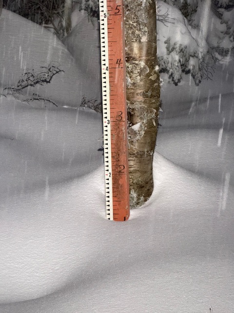
-

November 2025 general discussions and probable topic derailings ...
WinterWolf replied to Typhoon Tip's topic in New England
The difference is…for us/you those years are horrid. For DC those are good winters lol. It’s perspective. You’ll do fine this year. -
November 2025 general discussions and probable topic derailings ...
WinterWolf replied to Typhoon Tip's topic in New England
That is blatantly not true. You get years where you get early season snowfall. October ‘11. November of ‘12 November of ‘18. December of ‘19. October of ‘20. The list goes on. And you go years where you don’t. Period. When I was a young kid the winters were horrific..then they got real good. Then they got horrific again…you roll with the changes. -

2025-2026 ENSO
40/70 Benchmark replied to 40/70 Benchmark's topic in Weather Forecasting and Discussion
The big rise since July was a given....it was at record levels. -
Last year on this date, we were a hair lower than -2. This year's -1.31 is much better than last year (if you want snow in the east), so maybe we can make it sufficiently high enough to make a difference. There's still time in light of the trend over the last 3 months.
-

Mid to long range discussion- 2025
WinstonSalemArlington replied to wncsnow's topic in Southeastern States
-
 Graupel/rain showers south of town currently refracting beams of sunlight just outside the office
-
2025-2026 ENSO
40/70 Benchmark replied to 40/70 Benchmark's topic in Weather Forecasting and Discussion
I did wonder about warm ENSO before spring, but quickly relazed it wasn't happening. I do think we are nearing a PDO shift, but obviously not there yet. -
With how the tools available to the most amateur precip output model watchers have improved the last few years, it would be great to get to actually track something worthwhile again
-
yep many
-
100% with this, you'll like it @PrinceFrederickWx
-

November 2025 general discussions and probable topic derailings ...
amarshall replied to Typhoon Tip's topic in New England
couple of instagram stories of legit snow . Acton MA -
Getting damn near giddy. More persistent lake-effect snow appears most likely during the Sunday night through Monday evening time frame as very cold north- northwesterly low level flow sets up along Lake Michigan with H85 temperatures plunging to near -10 deg C above a still very warm lake surface (Lake-H85 difference around 20 C), courtesy of yet another (this time rather vigorous) short wave diving across the western Great Lakes during the day on Sunday. While it is difficult to iron out any specifics at this time range, this does appear to be something to watch over the next several days. The latest NBM shows roughly 60 percent probabilities of 4+ inches of 24-hour snowfall accumulation across Berrien, La Porte, and St. Joseph (IN) counties. Further, latest ECMWF EFI shows values of around 0.9 downwind of LM with Shift of Tails (SOT) values of 2 to 5. This would generally indicate greater confidence in potential for a more significant event relative to climatology. Stay tuned.
-
This has been the lowest 7 year run on record for the entire I-95 corridor from DCA to BOS. NYC has averaged 14.9” over this period. The last time NYC dipped under 18” for a 7 year stretch was back in 1992 during a much colder climate when they averaged 16.3”. So NYC able to have that 7 year to 10 year average jump back into 20s in the next few years since it was cold enough for a 50” season in 93-94 and a 75” season in 95-96. NYC hasn’t had a cold enough winter for 50” of snow since 14-15 which was before the big temperature jump in 15-16. Its unlikely NYC sees a 50” season and a 75” season absent a volcanic cooling not seen since the early 1800s during the remainder of the 2020s. So having both warm storm tracks and warm average winter temperatures has lead to this record low 7 year totals. That snow drought ending in 1992 was mostly a function of drier winters since the winter average temperatures were significantly colder than today. All the other prior snow droughts before 1992 when the NYC averaged under 20” for a 7 year stretch were also followed by 50” seasons. So those were the markers that the winter dry patterns were ending. The recent combination of record winter warmth and storm track warmth is a first for NYC.
-
In the city, LGA recorded 54 MPH; Stony Brook topped the night and recorded 70 MPH. https://partnerservices.nws.noaa.gov/products/cache/310-2025/PNSOKX/c8517c8ca3014c9eaf203ab033cd0360
-
Historical precedence argued against this, I remember doing research on this when hearing about all the El Niño hype. 2 years after a strong or super Nino goes -ENSO roughly 80% of the time.
-
Mid to long range discussion- 2025
WinstonSalemArlington replied to wncsnow's topic in Southeastern States
-
2025-2026 ENSO
40/70 Benchmark replied to 40/70 Benchmark's topic in Weather Forecasting and Discussion
Anyone know where Judah's fraud index landed? Guessing about normal? -

E PA/NJ/DE Autumn 2025 Obs/Discussion
bigtenfan replied to PhiEaglesfan712's topic in Philadelphia Region
To this day i wonder if the 1996 game was to be played in Philly instead of Dallas would Rendell have declared an emergency and postponed the game. -
 Truthfully, it hasn’t been much better than that lol. I stopped keeping track like I used to, but the last 5 seasons I’d guess we’ve averaged around 15-17” maybe? And that’s heavily skewed by the 3 feet in Jan 22
 -
Eh, it’s been a decade since those times, and we’ve paid for it dearly. The last 5 have been truly awful, but the 5 after 2015 weren’t great in the aggregate either. my main point stands. Early season snowfall is becoming increasingly difficult to come by. For reference, it’s been 14 years since we’ve had a white Christmas here, and I expect that to continue
-
the earth is still intact man
-
So who was the big winner with wind gusts last night? I thought my house was going to be blown over for a few seconds lol
-
Mid to long range discussion- 2025
WinstonSalemArlington replied to wncsnow's topic in Southeastern States
Veterans Day -
The strongest -IOD since 1996 is earth-shattering


