All Activity
- Past hour
-
The simulated radar products from the CAMs for the next 2 days look more like what I'd expect to see in July instead of late September.
-

September 2025 OBS-Discussion centered NYC subforum
NorthShoreWx replied to wdrag's topic in New York City Metro
12.7" @cp. I think EWR was the big winner of the NYC area airports, but don't recall their total -

September 2025 OBS-Discussion centered NYC subforum
psv88 replied to wdrag's topic in New York City Metro
So much for that sunny skies forecast -
The MJO waves have also been low amplitude unlike last year at this time when we were seeing strong waves and are projected to stay that way
-
A loss would bring up an interesting yet unfortunate scenario...our winning percentage is very good after a loss...In fact with Lamar starting I think we've only lost b2b maybe twice. BUT...we have KC next week and we gotta play there where Lamar has never won, lol But I hear ya though...ya start wondering about the law of averages, lol But home primetime losses in the all black uniforms are even more rare (I think we have like 1, lol). So maybe we'll be okay
-
Recovered from 38F to 70F by noon. You love to see it.
-

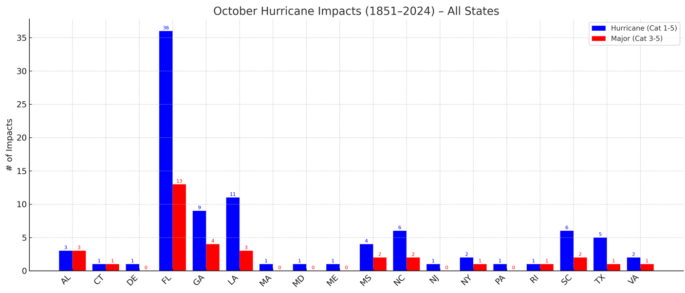
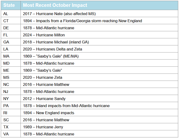
2025 Atlantic Hurricane Season
donsutherland1 replied to BarryStantonGBP's topic in Tropical Headquarters
For reference: Most Recent October Impacts:
-
one more season till disaster
-
GWDLT

-
Still incredibly cloudy in Frederick. Oh well, now I feel nudged to do more work.
-
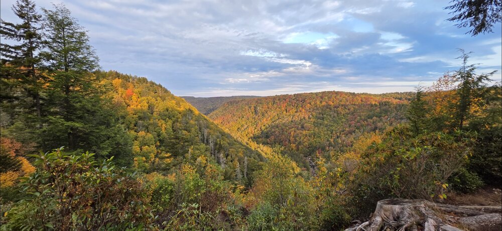
Surprisingly, Blackwater / Davis was near peak color this weekend. Picked a great time to go out.
-
Unlike Erin, it looks like the lead wave could get west enough where even if there’s a trough around there could be a land threat. Steering pattern still looks a bit weird though.
-

September 2025 OBS-Discussion centered NYC subforum
LibertyBell replied to wdrag's topic in New York City Metro
Less than Central Park? or about the same, Ed? -
September 2025 OBS-Discussion centered NYC subforum
NorthShoreWx replied to wdrag's topic in New York City Metro
JFK reported 10" -
I want a storm that’s extra tropical but identifies as a tropical storm
-
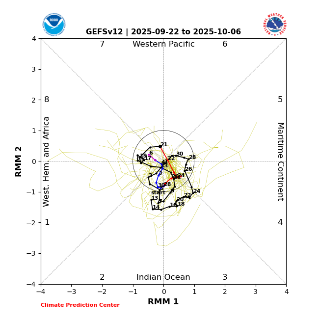
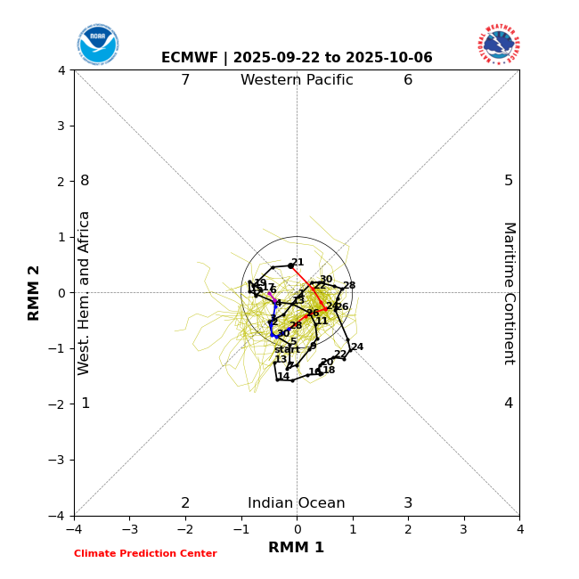
The unusual clockwise dominated MJO rotation that started Sept 1st is continuing and progged to keep going through at least Oct 6th per the images below. So, it went from phase 5 (inside) on 8/31 back to ph 2 9/2-8. It temporarily went forward to ph 3 for 3 days but then backtracked across 2 then 1 and then 8. It’s forecasted to continue backtracking through 7, 6, 5, 4, 3, 2, 1, and 8. I just looked at MJO diagrams for the 2nd half of each year back to 1975 and couldn’t find anything comparable:
-
September 2025 OBS-Discussion centered NYC subforum
LibertyBell replied to wdrag's topic in New York City Metro
PD1 was pretty big, there must have been more snowfall than ISP at JFK and some of the other south shore locations. -
Forecast called for sunny skies today but it’s nothing but clouds here. What the hell?
-
Yeah, given how utterly boring the weather has been here in Southern New England, even a tropical storm becoming extratropical over us would be a treat.
-
September 2025 OBS-Discussion centered NYC subforum
NorthShoreWx replied to wdrag's topic in New York City Metro
I said "snow depth" That mystery hasn't changed. FWIW those daily snowfall totals from ISP in 1979 look reasonable. Here is Syosset comparison for the same period: Syosset ISP 1979 F E B F E B Day 6 0.0 0.0 7 6.3 6.5 8 T 0.3 9 0.0 0.0 10 0.0 0.0 11 0.0 0.0 12 1.5 0.9 13 T T 14 0.0 0.0 15 1.0 T 16 0.2 0.2 17 0.0 0.0 18 0.0 0.0 19 10.1 8.8 -
The unusual westward MJO propagation continues
-
September 2025 OBS-Discussion centered NYC subforum
LibertyBell replied to wdrag's topic in New York City Metro
we really do not need or want this much flooding rain, 1-2 inches of rain like before is just fine and not days and days of depressing cloudiness either. -
September 2025 OBS-Discussion centered NYC subforum
LibertyBell replied to wdrag's topic in New York City Metro
I see 2017-2018 is on that list too that was one of our greatest bookend winters. -
September 2025 OBS-Discussion centered NYC subforum
LibertyBell replied to wdrag's topic in New York City Metro
Islip had some weird snowfall reporting back then, thankfully their snowfall reporting was good for February 1978 (unlike JFK). -
I'm intrigued as well. Certainly something to watch, but like you said, all speculation at this point until we get something to really develop. Lots of factors shall influence that these next few days. I just hope nobody is really expecting a cat 3 here I mean extratropical, subtropical, etc. storms can certainly still be noteworthy so don't want to take away from that aspect.