All Activity
- Past hour
-

Another Coating of Snow Saturday - "It's all we Got"
Spanks45 replied to Sey-Mour Snow's topic in New England
Yeah, they were both the most consistent, the GFS did as well, but backed away the closer we got The first round was fluff, I melted the 1.6" down to .08"...the stuff falling now is really heavy -
Euro has a storm for the 26th-27th. Looks icy.
-

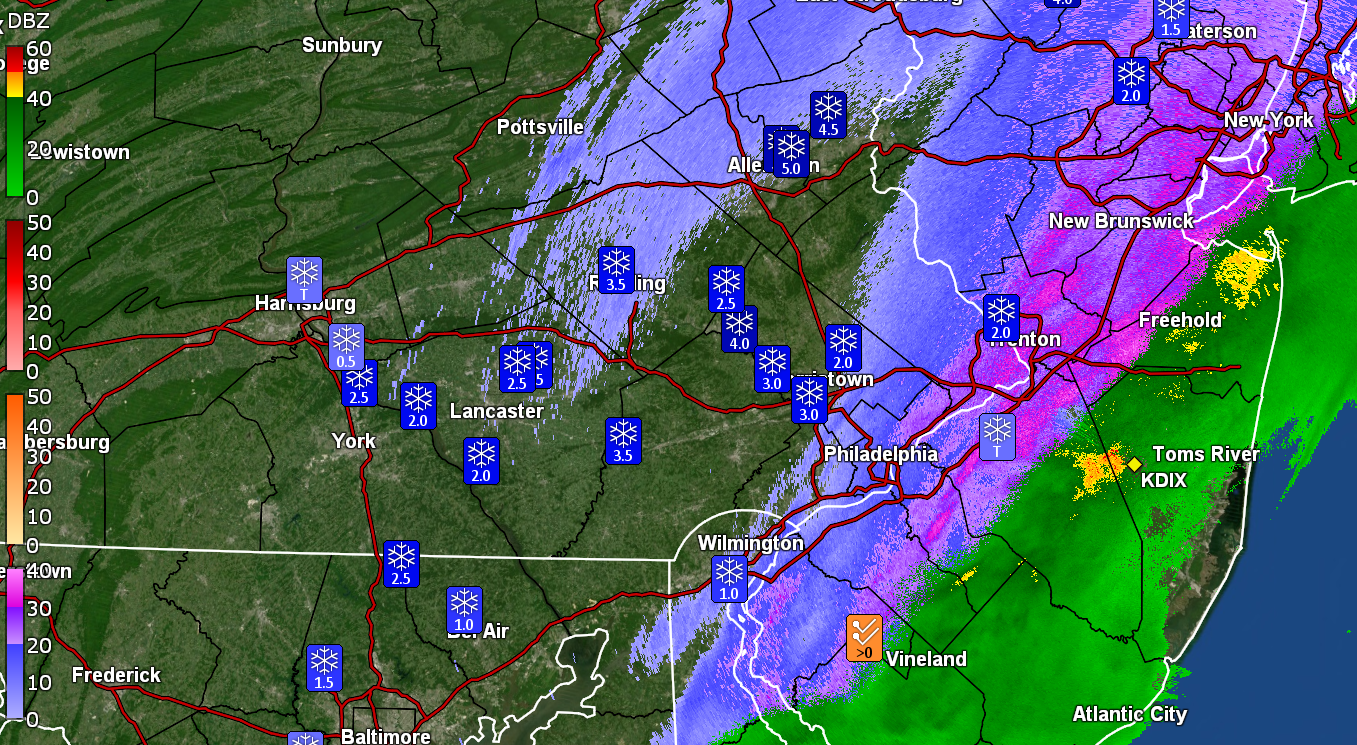
E PA/NJ/DE Winter 2025-26 Obs/Discussion
The Iceman replied to LVblizzard's topic in Philadelphia Region
Looks like 2” on my webcam in Levittown which is insane considering there was a dusting when I left at 10:45. Can anyone confirm that? I’m seeing 2.1” at Ewing. -
28 w/ lgt snow 4.6” otg
-

Another Coating of Snow Saturday - "It's all we Got"
kdxken replied to Sey-Mour Snow's topic in New England
Starting to move into southborough. First time this year I'd say it's legitimately snowing. -

E PA/NJ/DE Winter 2025-26 Obs/Discussion
Birds~69 replied to LVblizzard's topic in Philadelphia Region
Will tomorrow morning be a repeat? That would truly be snow on snow,,, -

First Legit Storm Potential of the Season Upon Us
WinterWolf replied to 40/70 Benchmark's topic in New England
Ya, we good inland here in CT….just bring the qpf. -

First Legit Storm Potential of the Season Upon Us
ORH_wxman replied to 40/70 Benchmark's topic in New England
Regular EPS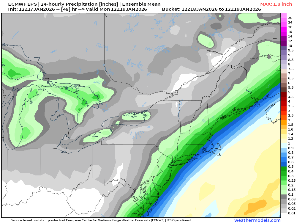
-
First Legit Storm Potential of the Season Upon Us
WinterWolf replied to 40/70 Benchmark's topic in New England
The machines knew….when nothing else did. Big win. -

Another Coating of Snow Saturday - "It's all we Got"
CoastalWx replied to Sey-Mour Snow's topic in New England
Maybe Ray won’t want to have the board get screwed now. -

First Legit Storm Potential of the Season Upon Us
WxWatcher007 replied to 40/70 Benchmark's topic in New England
High of 34.3 here. Down to 33.1 now with the snow picking back up. I think we're probably fine in CT tomorrow with temps. May be a bit more dicey to our east at least for a bit. -
Can confirm. Just drive from Croton to Ardsley and the roads are really bad.
-
Snow tapering off in Blue Bell, PA with 3”

-
People were worried about today and look. It should be colder tomorrow.
-

E PA/NJ/DE Winter 2025-26 Obs/Discussion
Hurricane Agnes replied to LVblizzard's topic in Philadelphia Region
Back edge is approaching and am down to SN- but up to 1.5" with a measurement. Definitely unexpected here but I had a hunch and had put my "Polar Shield" windshield cover on and flipped up the wipers yesterday anyway. Snow is starting to slough off the cars and temp has been holding at 33 with dp 32.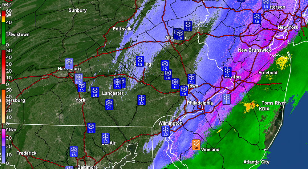
-
hopefully our rates would be similar tomorrow. Some temperature issues along the coast likely until we get some heavier rates. Most of the storms looks to be around 32-33 degrees.
-
Another Coating of Snow Saturday - "It's all we Got"
ORH_wxman replied to Sey-Mour Snow's topic in New England
Actually snowing good here now. Just got in on the edge. We’ll see for how long. Temp 33.5.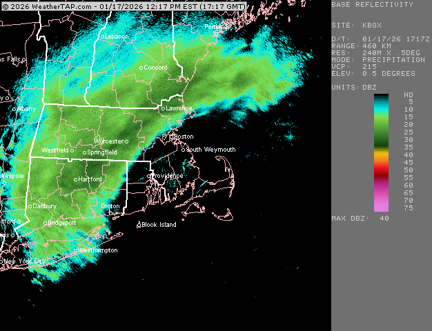
-
Frederick house got solid 1.5” and Kemp Mill a dusting
-
40-45 dbz returns knocking on my door. Still snow/graupel mix. 41.
-
Euro
-

Storm potential January 17th-18th
BoulderWX replied to WeatherGeek2025's topic in New York City Metro
3.5” - Morristown - 32* - Light snow -
.
-
Another Coating of Snow Saturday - "It's all we Got"
ORH_wxman replied to Sey-Mour Snow's topic in New England
Yeah both were consistently SE of other guidance on this. -
That is 1 strong signal around the 27thish
-

First Legit Storm Potential of the Season Upon Us
Baroclinic Zone replied to 40/70 Benchmark's topic in New England
12z skynet ensm going all in.


.thumb.jpeg.f5c6ba9d911ec96b3b124f8606aee58e.jpeg)

