All Activity
- Past hour
-
So finished a stretch of overnights ydy morning, and slept in long, so just looked at everything in the last hr, including previous runs. It's odd. You look at the solid full latitude 500 trough and it axis, and you wonder why a weak wave scoots out quickly ahead of the upper support, taking the baroclinic zone w/ it!!! Looking at 500 alone, it should much better at the sfc for a decent coastal. Also, now the models don't develop any real strong sfc low? Huh? Again, the 500 alone does not suggest this should happen! Big difference than 24 hr ago as well. The 500 cuts off *well* W of New England and is stronger than ydy, and moves over right over the region. That should promote a sfc low *not* scooting out to sea. However, it's not titled below. The 700 low is co-located and goes right over the region, so we get dry slotted! But we never got any sig precip to begin w/! CoastalWx's worst nightmare! LOL. Moisture is quite limited w/ the upper low, so that will just mean half-decent snows across the mtns of NNE probably. Ydy was better actually, since the 500 low cut S of the region. And the two decent troughs that occur down the road, can't do much either, at least on the 06z GFS! The 06z ECMWF looks better for something this weekend. It's been piecemeal in regards to snowfall across the region so far this winter, no one storm can deliver widespread mdt-hvy SN. Just sub-regions, like LI to Cape Cod and NNE get localized decent snows. Now, we get a fragmented storm coming that that can't consolidate right!? I can see now why CoastalWx is really getting ticked!
-
Sorry Don. You're not a statistician. And what you describe is not sensitivity analysis.
-

January 2026 Medium/Long Range Discussion
NorthArlington101 replied to snowfan's topic in Mid Atlantic
I'm a huge believer in Jan 23-Jan 28. Legit cold, OPs throwing out consistent hits (some historic) in the long range, great snow/precip means, etc. Don't see what isn't to like. -
lol this place cracks me up.
-
Bullying works in this context. The young ones always go thru this transition. Some slower than others. But they get there.
-
Line that can up, I’m about to boot that sumbitch with my steel toes. Lolol we’ll get a win here soon yall!
-
For those who are not familiar with it, sensitivity analysis incorporates uncertainty into an assessment. It is not deterministic in nature. It is not a point estimate. After the first 11 days of the month, the probability of a colder than normal January was just 55%. That means that there is still a lot of uncertainty. One sees it in the varying ensembles and weeklies and the lack of run-to-run continuity in cases. That's the key takeaway from any sensitivity analysis. It's capturing the large amount of uncertainty quite well, assuming one knows what one is looking at with the probabilities. For perspective, back in December, the estimated probability of a below normal monthly anomaly was 89% on December 7th. That was about as close to a "slam dunk" as one can get at such a long lead time. The estimated monthly mean temperature then was 34.0° (December finished at 33.8°). The major weakness is that the analysis assumes a Gaussian curve (normal distribution). Not everything is normally distributed. This assumption is necessary, because the kind of detailed model verification data that would be needed to construct a more robust curve is not publicly available. Thus, the simplifying assumption of a normal distribution is used. Finally, I include the estimated monthly mean temperature only because it's nice to have. But one should know what one is looking at. The estimated mean is similar to an ensemble mean, while the probability of an outcome plays the role akin to an ensemble spread (low probability reflects a large spread in outcomes due to high uncertainty). IMO, the probability of an outcome (I just use below or above normal) is really the more useful element of the piece concerning sensitivity analysis, especially at long lead times.
-
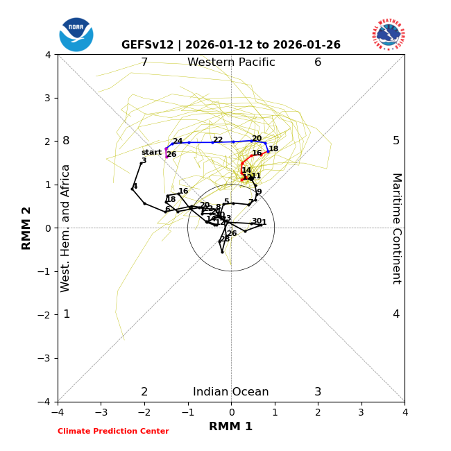
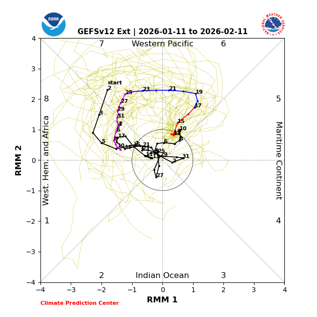
Not surprisingly, today’s GEFS mean prog has reduced the max amp of the phase 6-7 from the ~2.7 of two days ago to now being close to the Euro’s ~2.1 today (see below). But it retains the 17 day record breaking long winter phase 6. Also, note that today’s GEFS turns it left as it approaches phase 8: Yesterday’s ext GEFS didn’t turn as much: This change should be respected based on the stats for the # of DJF MJO days by phase since 2011 showing that phases 6/7 were the two most frequent phases day by day and that phase 8’s days numbered only ~1/3 of that of phase 7, which is likely due to the strong W Pac warm pool (where phase 7 resides): DJF: 1: 76 2: 96 3: 167 4: 173 5: 212 6: 249 7: 286 8: 95 Whether or not the MJO actually goes into phase 8 late this month and then proceed to 1-2-3 in the first half of Feb will probably play a big role as regards the chance for the +PNA to come right back (if it were to actually go back to a -PNA for ~a week just prior) and the resultant resumption of a cold E US as we look toward the 1st half of Feb. If it ends up not going into phase 8 in a meaningful way, the last 2 Euro Weeklies runs showing a mainly mild Feb would seem to have a better chance to verify. Let’s hope not for those who want it cold. @donsutherland1
-
2006 as well.
-
Should never start specific storm thread at this lead but we all knew the motive for it.
-
Yep. Known biases. Now, the biases change with the system.
-
Who is this dude and what did he do with the real bncho? But for real the post quality improved vastly and quickly haha
-
Make it 12 months of winter!
-

January 2026 regional war/obs/disco thread
tamarack replied to Baroclinic Zone's topic in New England
Nice! We had some mood flakes while driving home from Farmington last evening. Snow squalls are admittingly hit or miss, but we get the miss at a high percentage, except when we lived in Fort Kent where they were common. -
Agreed, and I don't know what's up with March this decade but there's only been snow in March 2022. The rest of the years have been snowless in March. March 2020 and 2023 was good for New England but mainly rain for us.
-
Anecdotally, this is the 2nd slowest start to winter storm names by the weather channel. I'm sure I'll get weenied for this, but I'm just introducing this evidence to show how dry it has been this winter. The slowest start to winter storm names by the weather channel was last winter, 2025. The weather channel isn't the best at adhering to their own criteria when naming the storms (2 million+ people have to be under winter storm warning in order for it to be named), but they're pretty good at adhering to their criteria aside from a few exceptions. Just goes to show how dry the past 2 winters have been. In 2023 and 2024, the lack of cold air was a problem for many east of the Plains. But in 2025 and 2026, there hasn't been a shortage of cold, there's been a shortage of precipitation. Almost like winter in the 1930s lol
-
Snow is good anytime, but February is melt season and often the beginning of mud season. December- and January snow is more emotionally and aesthetically valuable at our latitude.
-
Moderator bncho ladies and gentlemen.
-
I still think the only thing going for us is that NYC had a good december, and that tends to correlate well with the rest of winter (when it's a La Nina winter). But even now, we have fallen below average, and it just sees so hard to score something over here. We'll have to wait for a Feb 2015, Feb 2021, or Feb 2013 scenario. In all 3 of those years, most of December and January was a dud until end of the month and then we had a wintry February to bring us up to average or above average.
-
I noticed this coincided with the relay off the Pacific into the more physically realized sounding domain out west, which began taking place over the last 30 hours ...
-
You rolled the dice and got snake eyes apparently.
-
This 1,000%. So much has to be in place for a KU.
-
you're right, actually, h5 has been looking pretty damn good this winter (e.g. Jan 15 ULL) but those h5 looks aren't translating to the surface, where's it's often cold and dry.
-
Verification proves each run is more likely to be accurate now, however there is more chaos imo. 20 years ago I think I was able to use the models more functionally. They weren’t more likely to be correct but they had more consistent fail patterns you could adjust for. Now they fail in different ways that are impossible to predict run to run.
-
Agreed. The favorable "look" though always had some missing pieces in my book. No doubt it looked reasonably good aloft for a time and it was worth watching but some key pieces always seemed to be missing.


