All Activity
- Past hour
-
it was much better than I had expected. The call on the 2pt conversion was asinine though. WTF was that.
-
 medicine from mexico: MexicoGenerics :: mexico pharmacy online free shipping
 -
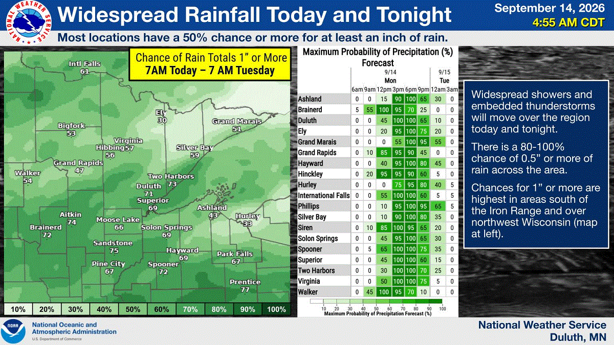
Rain just started here. Temps will be stuck in the upper 50s most of the day. Looks like a quality fall soaker, we need it.
-
My kids will be in their late 70s, I’ll be 109
-

Central PA Summer 2026 Discussion/Obs Thread
Itstrainingtime replied to Voyager's topic in Upstate New York/Pennsylvania
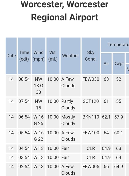
Good to hear! When I left for work this morning I was stunned at how humid it still was. Dewpoint was 62, now it's down to 53. -

Central PA Summer 2026 Discussion/Obs Thread
canderson replied to Voyager's topic in Upstate New York/Pennsylvania
Definitely a fall-like feel. Winds blowing in the upper 20s. -
Been 12 for me. I know NWS Blacksburg is having a basic class on the 17th at VT. Bit too far to go to. When I took what was then a 'refresher' back in 2014 at the local community college they even let me give a small spill/push for CoCoRaHS at the end to the other folks there.
-

2026-2027 Record-breaking El Nino
GaWx replied to Stormchaserchuck1's topic in Weather Forecasting and Discussion
I and others have been posting what the model trend has been for later this autumn for the various Nino regions (clearly downward), but am not suggesting anyone “trust” what the CFSv2 (or any model for that matter) shows since model progs sometimes verify poorly. Regardless of model imperfections though, a good portion of this and other forecasting discussion threads typically centers around the trends of model output even though the output isn’t typically “trusted”. Models are very useful tools even though they’re not at all crystal balls and thus can bust badly. I’ve found over the many years that I’ve been following them that model prog trends are quite worthy of discussion since they often give good hints on what’s actually liable to occur down the road regardless of their imperfections. A good example of another current forecasting thread that follows model trends is this one in the Mid-Atlantic forum that I and some others here also post in and which I recommend others check out: -

E PA/NJ/DE Autumn 2026 Obs/Discussion
Birds~69 replied to PhiEaglesfan712's topic in Philadelphia Region
DP 54F....that's all you need to know. -
certified canadian pharmacy and canadian pharmacy store canadian pharmacy official site http://www.google.cv/url?q=http://northrxcanada.com legit canadian pharmacy or http://www.servinord.com/phpBB2/profile.php?mode=viewprofile&u=806215 canada rx pharmacy [url=https://images.google.com/url?q=http://northrxcanada.com]online pharmacy canada[/url] canada pharmacy world and [url=http://ussher.org.uk/user/mhsoukokrq/?um_action=edit]canadian pharmacy legit[/url] canadian pharmacy 365
-
It’s been 13 for me hahaha
-
Yeah missed FG and extra point shouldn’t have happened. But given how awful they looked last year, take the small win to only lose by 2!
-
Meh, looks like Fall arrives next week. Gotta enjoy this weather while we have it.
-

2026-2027 Record-breaking El Nino
LakePaste25 replied to Stormchaserchuck1's topic in Weather Forecasting and Discussion
To verify sure, there’s no requirement in how one gets there. It’s more about trusting the prognosis to begin with. Say it’s 100 in Atlanta. A model says starting tomorrow, we will see the forecast high drop 5 degrees every day for the next 6 days. So in a few days it’ll only get to 80 in Atlanta. It’s now tomorrow, and the high didn’t drop 5 degrees. It’s 99. Continue on to the next day, it’s 100 again. Why should I trust what the model is saying 3 weeks out when it’s making such a massive forecast error 2-5 days out? -
2026-2027 Record-breaking El Nino
GaWx replied to Stormchaserchuck1's topic in Weather Forecasting and Discussion
Today’s weekly relative update (which has been NOAA’s official way of measuring these for quite awhile now) for last week cooled in Nino 1+2 from +3.9 to +3.7 and in Nino 4 from +0.1 to -0.1. Meanwhile, Nino 3 warmed from +2.7 to +2.8 while Nino 3.4 warmed from +1.8 to +2.0: 02SEP2026 3.9 2.7 1.8 0.1 09SEP2026 3.7 2.8 2.0 -0.1 This is the comparable week in 1997: 10SEP1997 3.8 2.6 1.8 0.5 This tells me that 2026 remains more E based than 1997 and was thus for another week the most E based on record for this time of year. -

2026-2027 Record-breaking El Nino
forkyfork replied to Stormchaserchuck1's topic in Weather Forecasting and Discussion
yes there is - Today
-
September 14 2099: The next total solar eclipse will take place over Minnesota. It will be visible in the Twin Cites, depending on the weather. (Note: My g & gg kids will be old folks then ) 1964: The earliest official measurable snowfall occurs in Minnesota with 0.3 inches at International Falls. 1852: Early frost hits Ft. Snelling and ends the growing season. For Monday, September 14, 2026 1937 - The mercury soared to 92 degrees at Seattle, WA, a record for September. (The Weather Channel) 1944 - A very destructive hurricane swept across Cape Hatteras and Chesapeake Bay, side swiped New Jersey and Long Island, and crossed southeastern Massachusetts. The hurricane killed more than four hundred persons, mainly at sea. The hurricane destroyed the Atlantic City NJ boardwalk. (David Ludlum) (The Weather Channel) 1970 - The temperature at Fremont, OR, dipped to 2 above zero to equal the state record for September set on the 24th in 1926. (The Weather Channel) 1987 - Barrow, AK, received 5.1 inches of snow, a record for September. (Sandra and TI Richard Sanders - 1987) 1987 - Thunderstorms developing along a cold front produced severe weather from Minnesota to Texas. Thunderstorms in Iowa produced baseball size hail at Laporte City, and 80 mph winds at Laurens. Hail caused more than ten million dollars damage to crops in Iowa. Thunderstorms in Missouri produced wind gusts to 75 mph at Missouri City and Kansas City. A thunderstorm in Texas deluged the town of Fairlie with two inches of rain in just two hours. (Storm Data) (The National Weather Summary) 1988 - Hurricane Gilbert made the first of its two landfalls on Mexico, producing 170 mph winds at Cozumel. (The Weather Channel) 1988 - Thunderstorms produced severe weather over the Texas panhandle during the evening hours. One thunderstorm spawned a strong (F-2) tornado in the southwest part of Amarillo, and deluged the area with five inches of rain. The heavy rain left roads under as much as five feet of water, and left Lawrence Lake a mile out of its banks. Hurricane Gilbert lost some of its punch crossing the Yucatan Peninsula of Mexico. Its maximum winds diminished to 120 mph. (The National Weather Summary) (Storm Data) 1989 - Unseasonably cool weather prevailed across the south central U.S. Eight cities reported record low temperatures for the date, including Raton NM with a reading of 30 degrees. The afternoon high of 59 degrees at Topeka KS marked their third straight record cool maximum temperature. Unseasonably warm weather continued in the Pacific Northwest. Seattle WA reported a record eight days in a row of 80 degree weather in September. (Storm Data) (The National Weather Summary) Observances: 14 Mon National Live Creative Day 14 Mon National Sober Day 14 Mon Ganesh Chaturthi 14 Mon National Coloring Day 14 Mon National Cream Filled Donut Day 14 Mon National Food Is Medicine Day 14 Mon National Rosa Tequila Day 14 Mon National Virginia Day 14 Mon Gobstopper Day 14 Mon National Eat a Hoagie Day
-
love these cancel winter predictions in September especially when the Cansips model is now predicting the warmest water in the Pacific to be in the central area of the Pacific (Modoki) not along the South America coast. I am suspecting that this upcoming winter will be similar to last winter - for different reasons of course -especially mid -late January through February
-
2026-2027 Record-breaking El Nino
GaWx replied to Stormchaserchuck1's topic in Weather Forecasting and Discussion
Today’s SOI is at ~-26. That’s the 33rd straight -SOI. The 30/90 day averages are at -17.5/-20.3: https://www.longpaddock.qld.gov.au/soi/ -
Central PA Summer 2026 Discussion/Obs Thread
canderson replied to Voyager's topic in Upstate New York/Pennsylvania
Yea but you’re 128 years old. -
2026-2027 Record-breaking El Nino
LakePaste25 replied to Stormchaserchuck1's topic in Weather Forecasting and Discussion
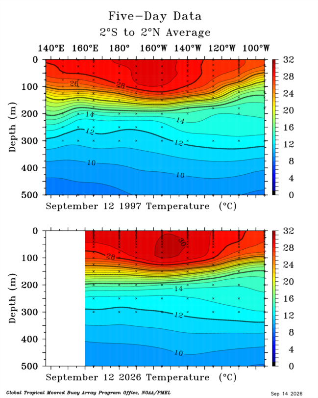
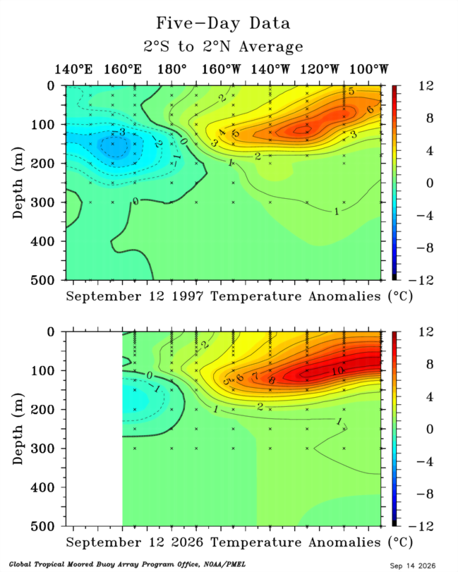
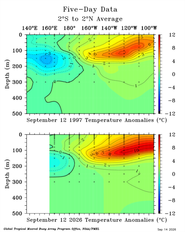
Further east and a much greater volume of warm water than 1997 with the 30C isotherm approaching 140W: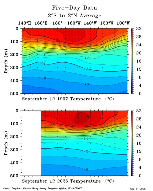
-
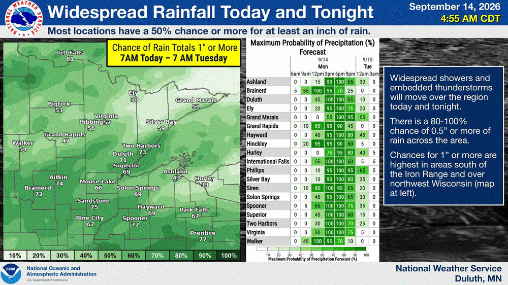
Upper 20's-30's (40's along the shore) across NE MN. Very chilly mid Sept morning. Now let it rain
-
2026-2027 Record-breaking El Nino
GaWx replied to Stormchaserchuck1's topic in Weather Forecasting and Discussion
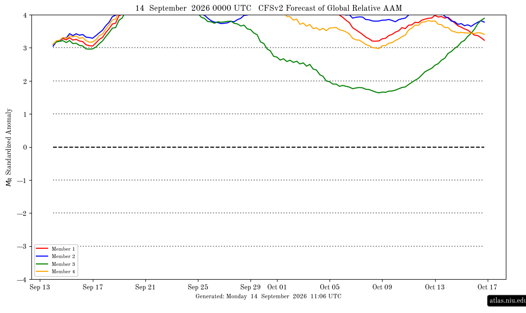
The AAM yesterday finally for the first time this month exceeded an impressive +3 per the following image after several early Sep runs had had that occurring by Sep 7-8th. The delay is typical due to a + bias of the CFSv2. This is saying it will hit an extreme level of +4+ in only ~5 days (~Sep 19th), which is the earliest in its forecast that I’ve ever seen it reach it, and that it will stay +4+ at least through Sep 24th. I’ll keep following these graphs to see if that actually occurs: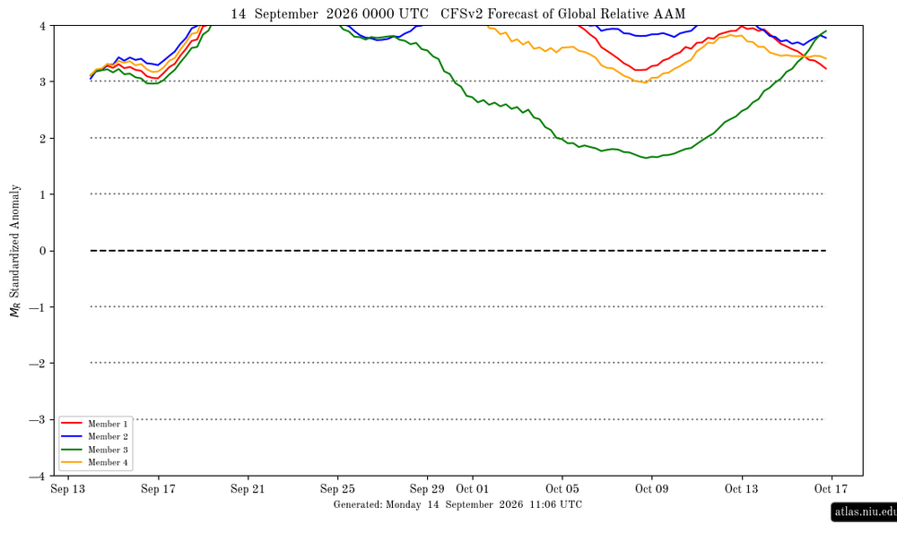
-
Nice breeze this AM blowing away some of the souptember feel. Should be nice DPs until the end of the week. Enjoy!
-

Septorcher 2026 Discussion - Endless Summer
kdxken replied to Damage In Tolland's topic in New England
Boom. And down we go.