All Activity
- Past hour
-

December 2025 regional war/obs/disco thread
SnowGoose69 replied to Torch Tiger's topic in New England
That was just a wild winter, such a crazy +AO/NAO fairly far removed from the solar max and also in a weak to moderate El Nino. -

E PA/NJ/DE Winter 2025-26 Obs/Discussion
RedSky replied to LVblizzard's topic in Philadelphia Region
The brief period of snow on the ECM Boxing Day starts at dark lol -

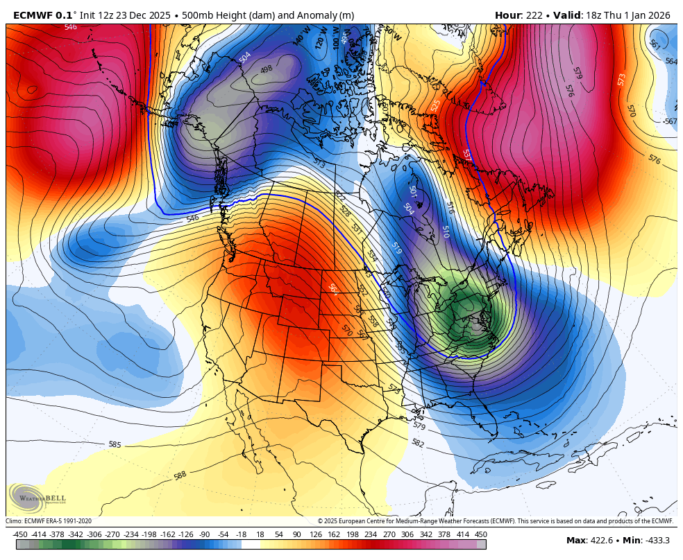
2025-2026 ENSO
PhiEaglesfan712 replied to 40/70 Benchmark's topic in Weather Forecasting and Discussion
It looks like we go warm by the 2nd week of January, which makes sense, considering we haven't had a December and January go all the way cold since 2010-11:
-

White Christmas Miracle? December 23-24th
mahk_webstah replied to Baroclinic Zone's topic in New England
Bumped up here to 3 to 6 inches with an advisory -
four threads in December? I’m pretty content with giving it at least a B.
-

December 2025 regional war/obs/disco thread
The 4 Seasons replied to Torch Tiger's topic in New England
Yeah i was looking at this recently because im getting ready to work on the 94-95 season. NYC got 10.8" from that storm and 11.6" all winter total. If it werent for that storm they would have had 0.8" on the winter, which would have made it, by far the worst season in history. Along with a lot of other climo sites, it would have been the worst winter ever including ORH. -
Most likely yes. Nam will sniff this out as we get closer (only thing its useful for)
-

Mid to long range discussion- 2025
WinstonSalemArlington replied to wncsnow's topic in Southeastern States
-

December 2025 regional war/obs/disco thread
brooklynwx99 replied to Torch Tiger's topic in New England
really likes the NYE timeframe. has the TPV take a trip south and boom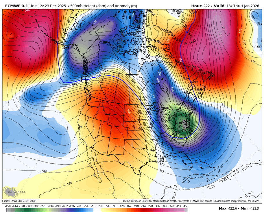
-
Been fast flow and shredded systems for years now. Guess it's make up for all those years of KUs
-
This is where you have to look at soundings and the mid level low tracks-700 and 850. If those lows go north of you you’re essentially guaranteed to mix and there will definitely be a warm nose somewhere with a system like this and sleetfest zone.
-
E PA/NJ/DE Winter 2025-26 Obs/Discussion
RedSky replied to LVblizzard's topic in Philadelphia Region
ECM op is 1-3" snow to ice ice ice -
Not sure what your looking at but shows .25-.50” Qpf as frozen for northern Md
-
salisbury getting tea bagged?
-
RRFS is a squashed mess at 84, looks like if you extrapolate it we'd barely get a thing. That said, it was a squashed mess at 84 with today's system too. Maybe a bias of the model? Will have to see where we are in 3 days but its interesting to see it do the same. If we want to take its idea as gospel and assume same thing happens, something exactly like the Euro would happen.
-
-

December 2025 regional war/obs/disco thread
WxWatcher007 replied to Torch Tiger's topic in New England
Shredded is a continued theme of the season. Comes with the fast flow though I guess. -
Not saying its right but gfs is all snow north of ttn
-
All frozen is good.
-

White Christmas Miracle? December 23-24th
ORH_wxman replied to Baroclinic Zone's topic in New England
Not optimistic. There’s an area of forcing knifing SE that is supposed to blossom Some snow for eastern areas later on this evening…that’s what could give a quick burst of actual half-decent rates. But it could also stay too far northeast. The dying WAA tries to rejuvenate some weaker echoes this afternoon but I am not counting on anything from that. For far eastern MA, they might try and sneak a piece of the IVT tomorrow….but that is low probability. -
That's at least half sleet south of Rt. 78. Put that 6" line from Rt. 80 in northern Jersey, NYC, and mostly all of Long Island. As of right now. Things will almost certainly change a bit by Friday.
-

E PA/NJ/DE Winter 2025-26 Obs/Discussion
Duca892 replied to LVblizzard's topic in Philadelphia Region
I try my best to understand these. So if you are sandwiched between the red line from mid PA to the blue line in NE PA that is a cold rain? -

White Christmas Miracle? December 23-24th
Great Snow 1717 replied to Baroclinic Zone's topic in New England
Why are you asking???...you wrote that 1-4 has been guaranteed for days... -
Time to move on
-

December 2025 regional war/obs/disco thread
Kitz Craver replied to Torch Tiger's topic in New England
EURO is pretty meh. Tries to hang some moisture back, but it’s light and diffuse looking.