All Activity
- Past hour
-

2026-2027 Super El Nino
bluewave replied to Stormchaserchuck1's topic in Weather Forecasting and Discussion
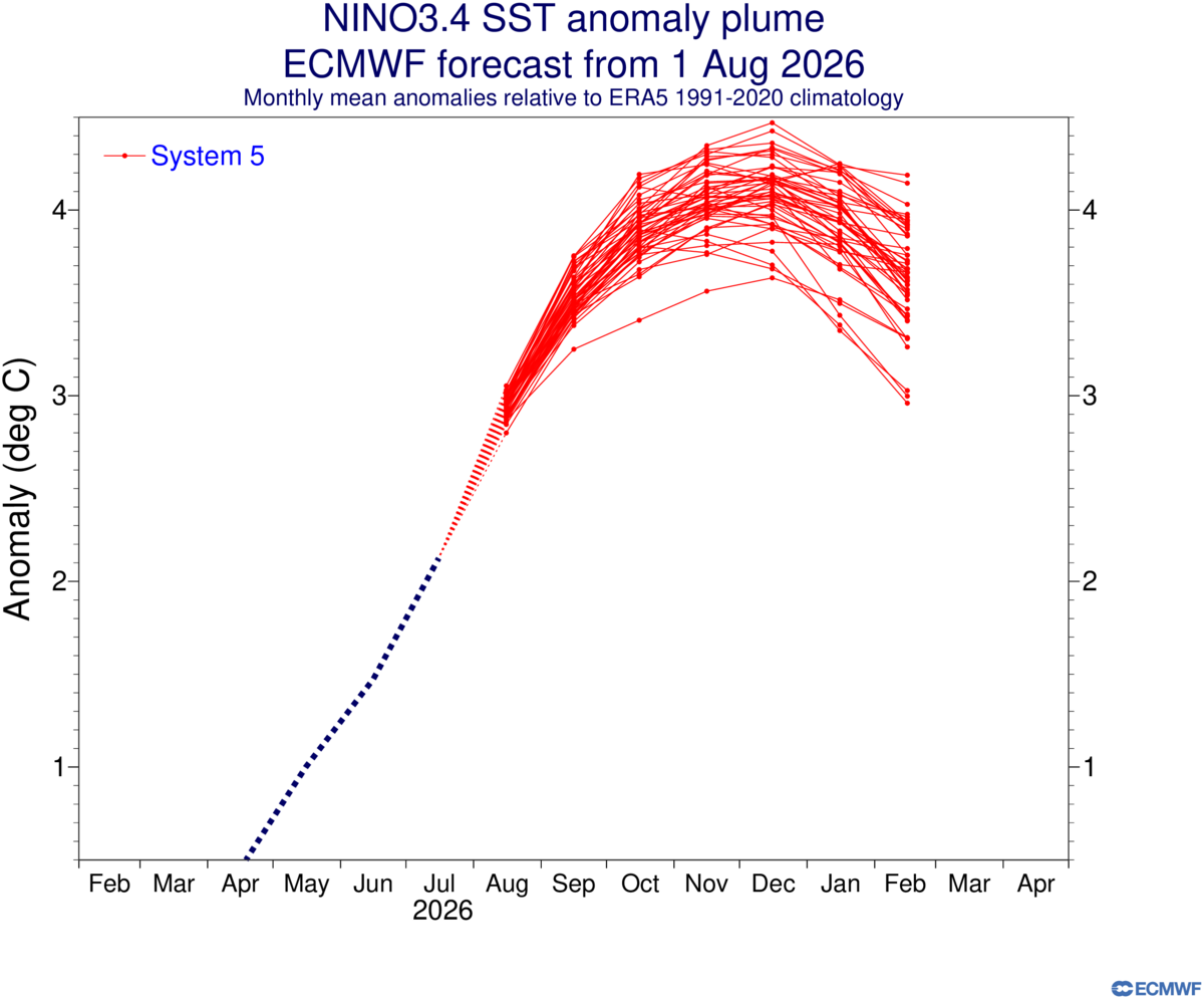
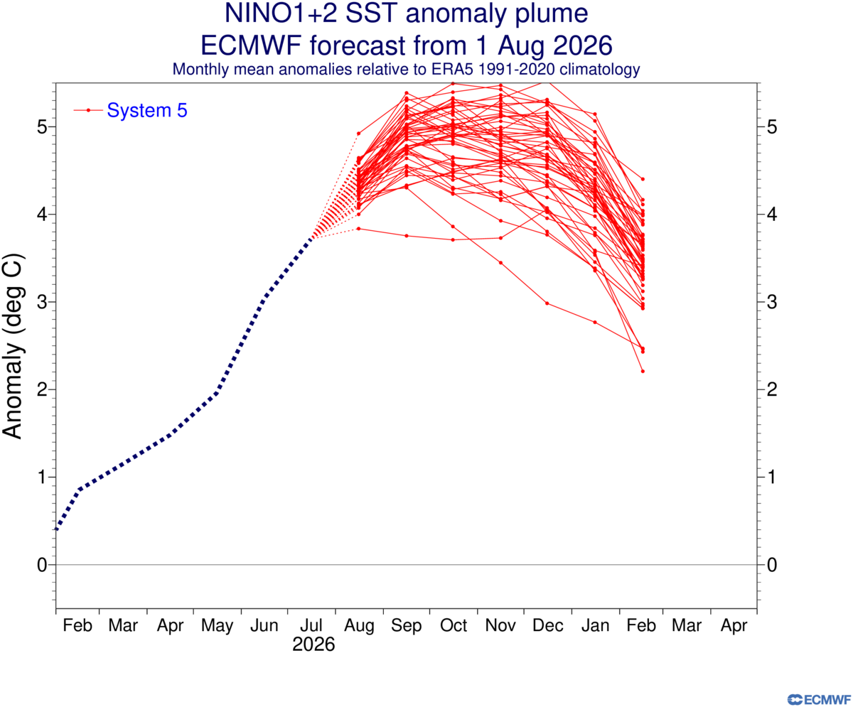
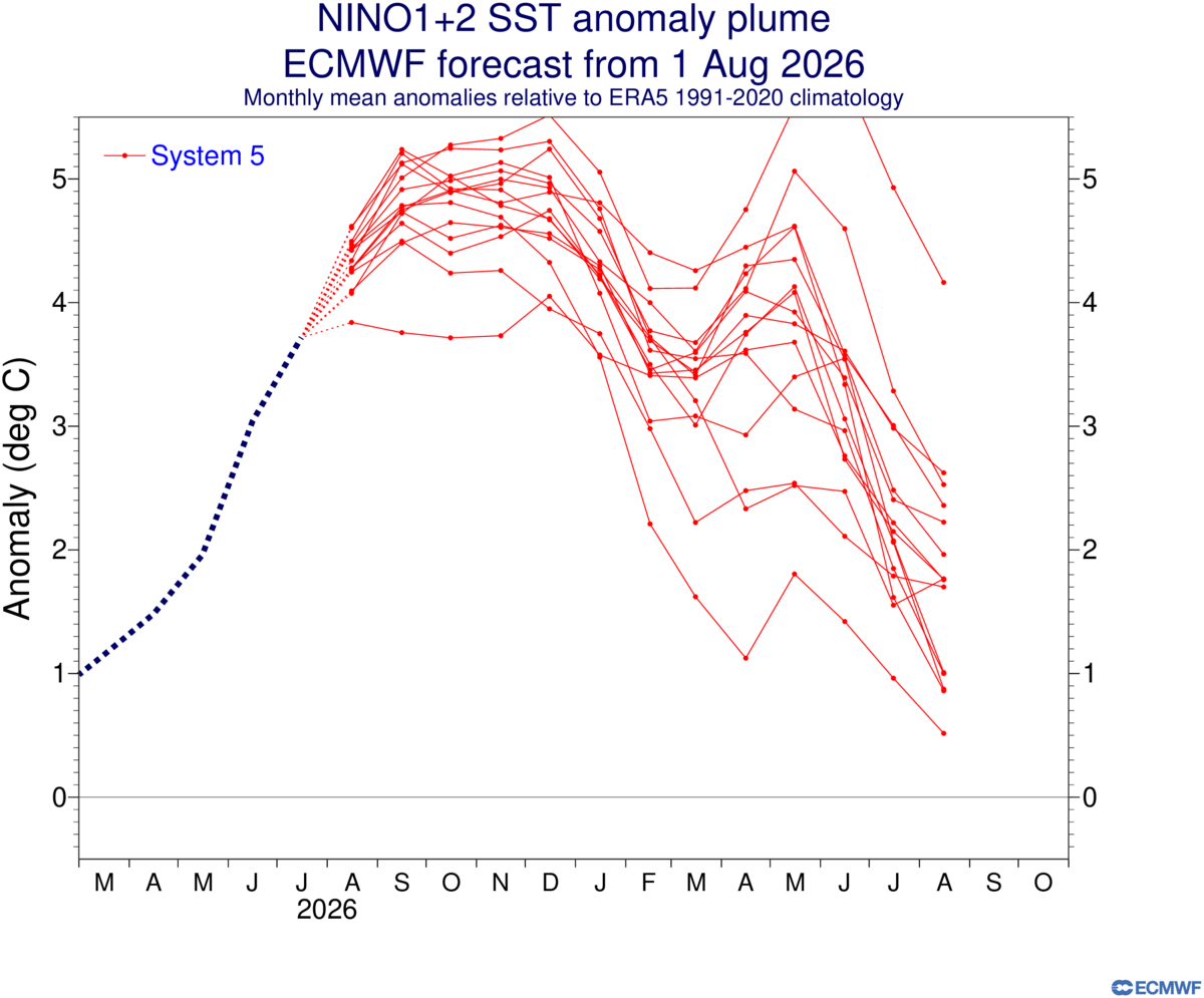
Latest Euro update has the Nino 3.4 ONI values peaking around +4. The Nino 1.2 ONI values are now approaching +5. The longer range plumes have Nino 1+2 remaining elevated into next spring and summer.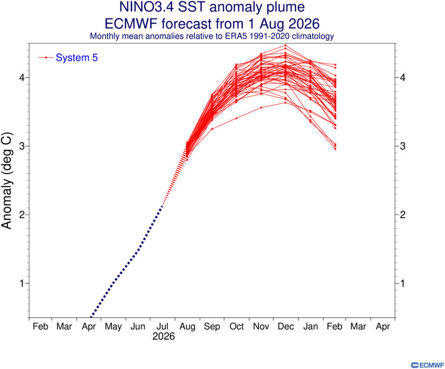
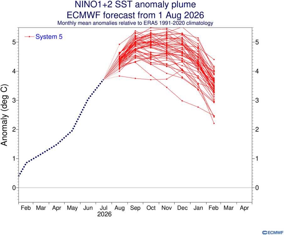
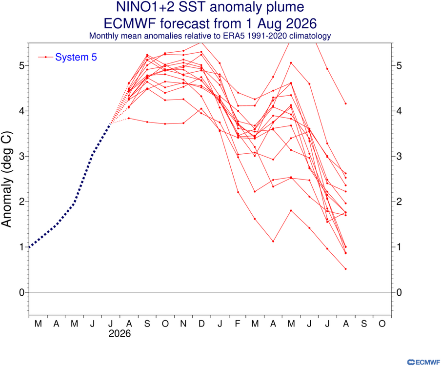
-
Moderate rain now...looks like my area lucked into this batch
-

2026-2027 Super El Nino
GaWx replied to Stormchaserchuck1's topic in Weather Forecasting and Discussion
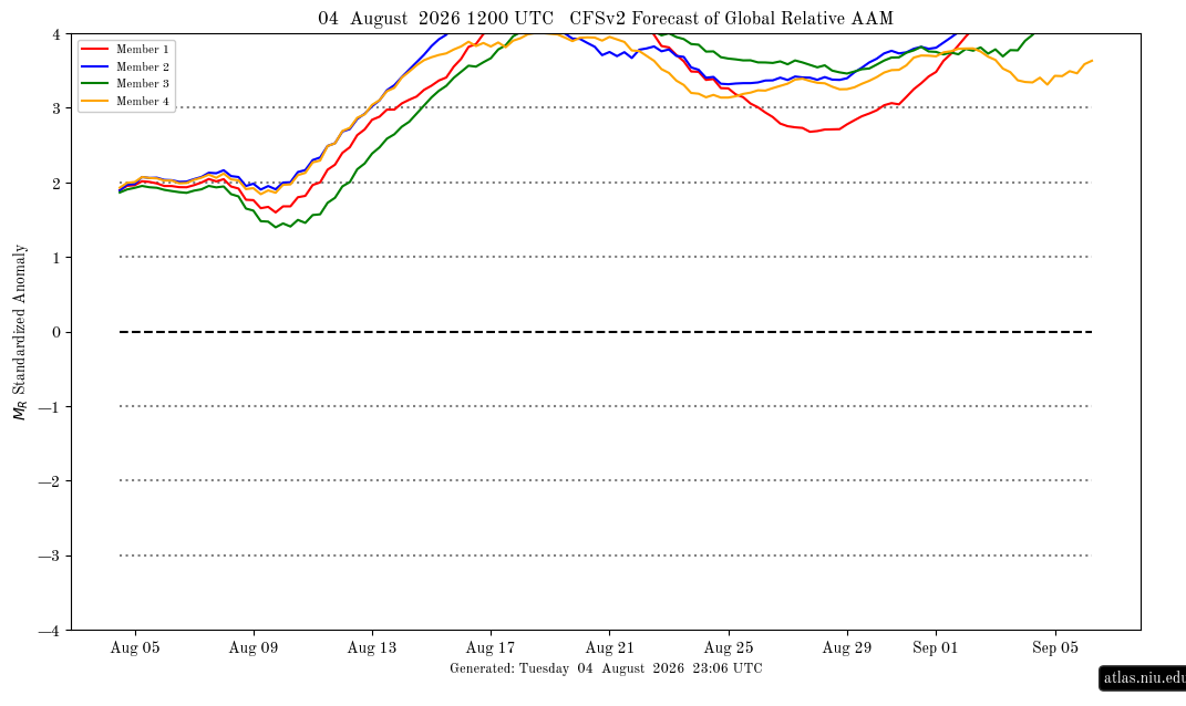
Yesterday’s 12Z CFSv2 run has the AAM at 4+ for all 4 members simultaneously for only the 2nd run I’ve ever seen! This has that on day 15 (Aug 18th) although it is just for that one day. The only other run that I’ve seen with all 4 members at 4+ at the same time is the 8/1/26 12Z run and it didn’t have that til way out only 3 days from the end of the run (day 32 or 9/1/26)! @snowman19 12Z 8/4/26 CFSv2 AAM: all >4 on 8/18/26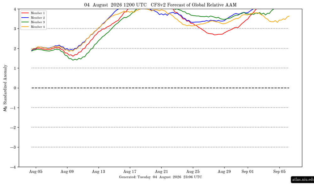
-

Augdewst 2026: Summer's Last Stand
Damage In Tolland replied to Prismshine Productions's topic in New England
I thought he meant this week or something -

2026-2027 Super El Nino
LakePaste25 replied to Stormchaserchuck1's topic in Weather Forecasting and Discussion
This is like me saying you don’t agree it’s east based because you don’t like using the ELI. I simply didn’t like how the MEI was a limited dataset nor did I need to wait for this monthly updated to figure out it was coupled. -
Nice steady rain currently
-

2026-2027 Super El Nino
40/70 Benchmark replied to Stormchaserchuck1's topic in Weather Forecasting and Discussion
You don't feel that ENSO is coupled with the tropics right now? I guess we can agree to disagree, then. I prefer a to use all of them TBH, and they all imply the same thing...ENSO is driving the tropics attm. -
2026-2027 Super El Nino
LakePaste25 replied to Stormchaserchuck1's topic in Weather Forecasting and Discussion
We can agree to disagree. SOI, VP anomalies, and OLR anomalies will also tell me if it’s coupled and I much prefer using those. I’m just not a fan of using it. -

Augdewst 2026: Summer's Last Stand
CoastalWx replied to Prismshine Productions's topic in New England
We just had 2 weeks of BN. -
2026-2027 Super El Nino
40/70 Benchmark replied to Stormchaserchuck1's topic in Weather Forecasting and Discussion
There is definitely a correlation....obviously the mid latitudes stand a better chance of being in sync with the tropics of the MEI is higher, but it's not absolute. Kind of akin to how the AO is correlated to colder mid latitude winters, but there are always exceptions when areas outside of it's domain are pervasive drivers. -

Central PA Summer 2026 Discussion/Obs Thread
Mount Joy Snowman replied to Voyager's topic in Upstate New York/Pennsylvania
Yeah, it's going to be muggy as heck for a few days. Could see dews above 75 from tomorrow through Saturday, with daily chances for afternoon storms. Some people might really make out with this airmass, even more than they'd like. -
I hope so. I dont mind the humidity now.... but i hate like mid 90s and blazing sun and mid 70s DP
-
the clouds and potential storms along with heat and high humidity around the Bermuda HP backed up into the region overnight - here we go again.....
-
Seems really temporary? Monday and Tuesday only and then possibly a strong cold front?
-

Augdewst 2026: Summer's Last Stand
tamarack replied to Prismshine Productions's topic in New England
July 17-30 here was 3.4° BN. I'm guessing that most of New England was normal or BN during those 2 weeks. -
2026-2027 Super El Nino
40/70 Benchmark replied to Stormchaserchuck1's topic in Weather Forecasting and Discussion
MEI is great for what it's designed to do...assess how well coupled ENSO is with the tropical atmosphere: The bi-monthly Multivariate El Niño/Southern Oscillation (ENSO) index (MEI.v2) is the time series of the leading combined Empirical Orthogonal Function (EOF) of five different variables (sea level pressure (SLP), sea surface temperature (SST), zonal and meridional components of the surface wind, and outgoing longwave radiation (OLR)) over the tropical Pacific basin (30°S-30°N and 100°E-70°W). I'm not sure why it should be viewed as a quality assessment outside of that bounded area of the tropical Pacific....it's not going to be able to detect how well the tropics are in sync with the mid latitudes, rather it is designed to measure the quality of the coupling between the ocean and atmosphere in the tropical Pacific. The RONI is probably better equipped to gage the link between the tropics and mid latitudes, but ultimately I think we just need to dig in an assess for ourselves like Chris has been doing. I don't care is the MEI is 5.3, there is still obviously a prism between the tropics and mid latitudes and no, that isn't necessarily a "good" thing for winter. -
Augdewst 2026: Summer's Last Stand
Damage In Tolland replied to Prismshine Productions's topic in New England
An earlier post said back BN. It was never there -
0.00” here overnight and yesterday. First miss in a long time
-
Not liking seeing mid 90s and humidity return next week
-
 https://sildoliko.com/# sildenafil 50 mg price
 -

Central PA Summer 2026 Discussion/Obs Thread
canderson replied to Voyager's topic in Upstate New York/Pennsylvania
Holy humidity, Batman -
Augdewst 2026: Summer's Last Stand
CoastalWx replied to Prismshine Productions's topic in New England
We may get a touch BN late next week. -

Chester County PA - Analytical Battle of Actual vs. Altered Climate Data
chubbs replied to ChescoWx's topic in Climate Change
When you focus on periods just before and just after station changes, the changes are have very strong statistical significance. Below is an example for Coatesville, using the monthly difference between Coatesville and West Chester. On average, Coatesville was 2.5F cooler relative to West Chester in 1949-50 vs 1944-45, before the 1946 move. The stats show that the move-related change was highly significant statistically.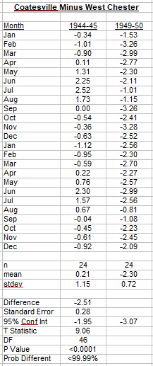
-
Augdewst 2026: Summer's Last Stand
Damage In Tolland replied to Prismshine Productions's topic in New England
How can it go back below normal if it was never there in the first place ? -
2026-2027 Super El Nino
40/70 Benchmark replied to Stormchaserchuck1's topic in Weather Forecasting and Discussion
None of us are perfect...best any forecaster can do is try to keep an open mind, be willing to admit error and look to improve. My outlooks got a lot better the moment I stopped perceiving alternative view points as a threat and tried incorporating them....truth is that every individual has something to offer.