All Activity
- Past hour
-
The farm country in central Aroostook is closer and that area has some Midwest-type blizzards. (Not this year so far, however.)
-
Switched over to snow here. About 6 hours ahead of schedule
-
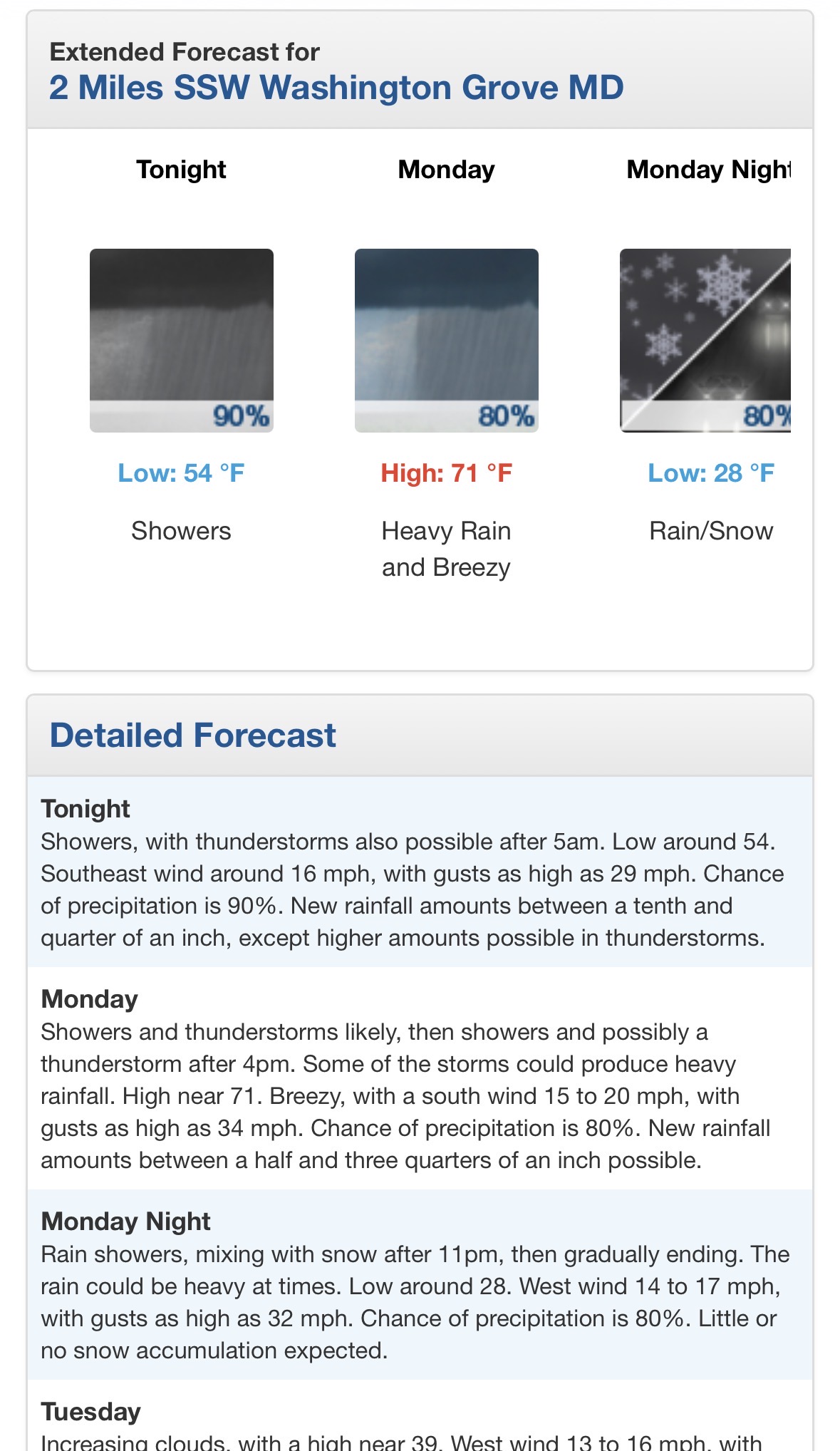
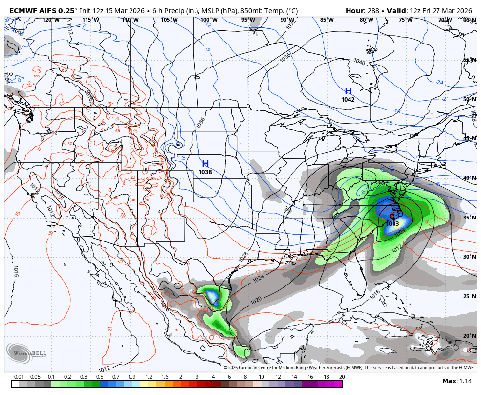
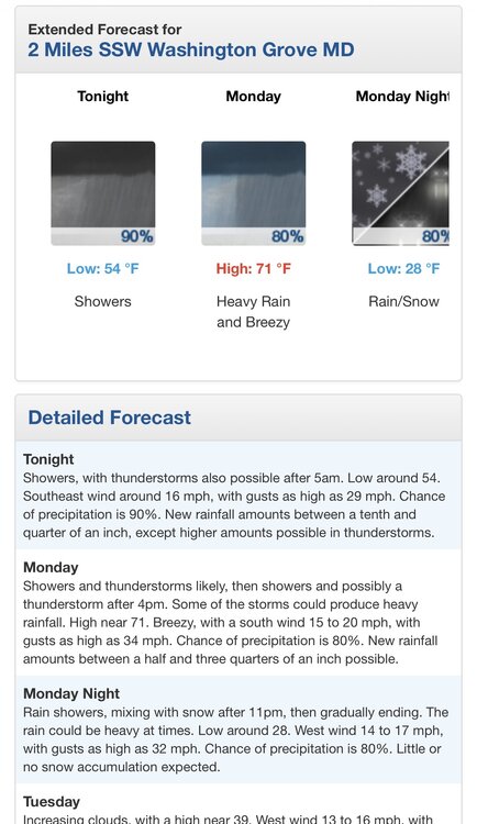
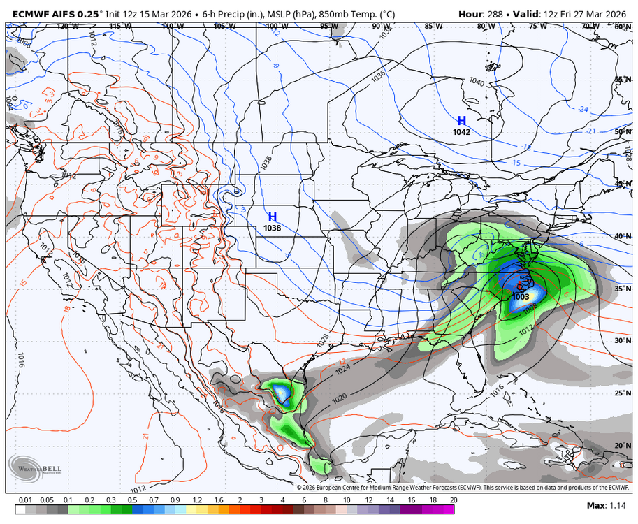
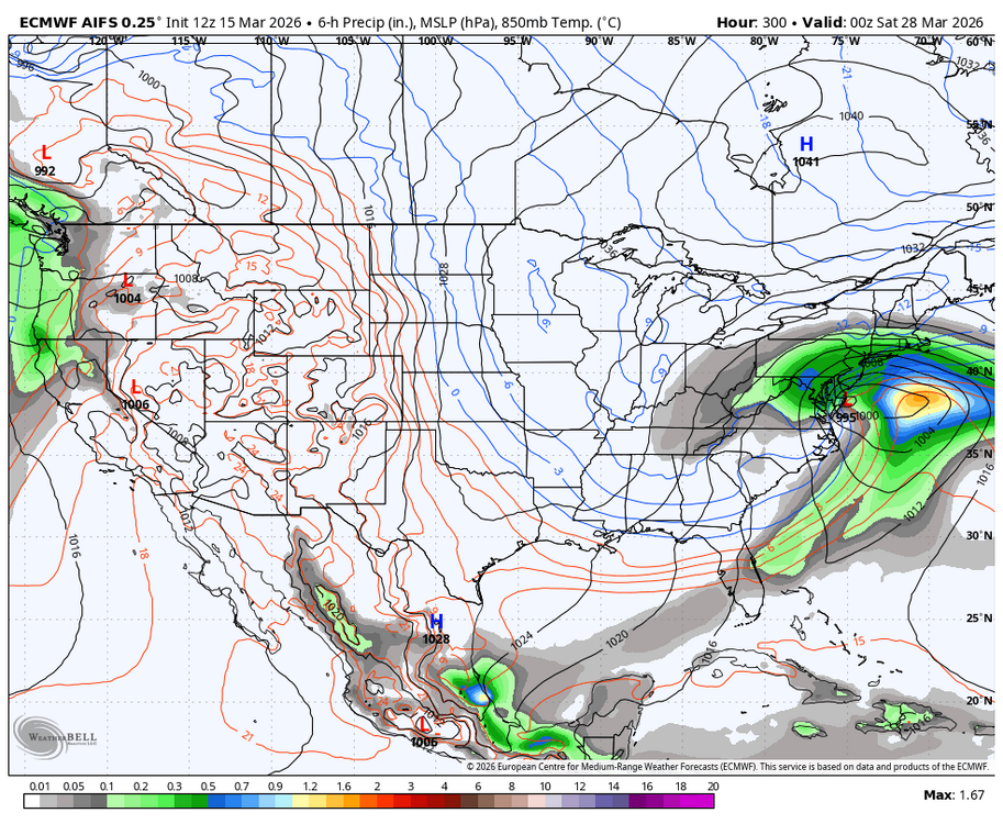
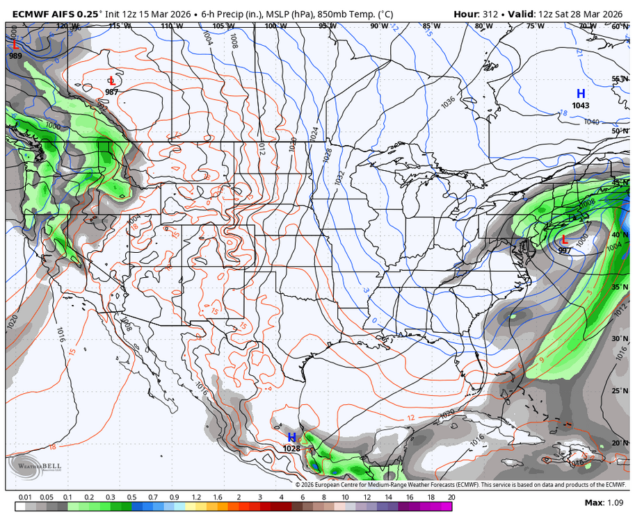
Afternoon AFD from LWX DISCUSSION... KEY MESSAGE 1...A strong cold front pushes across the forecast area Monday, bringing gusty winds and potential for severe thunderstorms capable of producing significant damaging winds and tornadoes. Surface high pressure shifts eastward over New England a CAD wedge bringing cooler conditions and cloudy skies to those east of the Blue Ridge. Southerly flow increases moisture in the atmosphere, with light rain showers observed on KLWX radar as of 3PM. Precipitation chances continue increasing as a potent low pressure system traverses across the Great Lakes into Canada, pushing the associated fronts across the Mid- Atlantic. The associated warm front lifts through the area overnight. A band of showers accompanies this warm frontal passage tonight. This comes with low clouds and continued breezy southeasterly winds. Depending on how quickly this boundary can lift north of the area, some residual stratus may linger across the Mid- Atlantic region on Monday morning. These should gradually scour out though ahead of the powerful cold front off to the west. Once this occurs, a more robust pre- frontal southerly wind overspreads the region. Outside of any thunderstorms, expect southerly gusts to around 25 to 35 mph, locally nearing 45 to 50 mph in the mountains. Gradient winds ahead of the front increase with a Wind Advisory in effect for the higher elevations on Monday. Wind gusts up to 55 mph are possible along the ridges. As an upper low gradually closes off near Lake Michigan, a shortwave begins to sharpen over the Mid-South midday Monday. As this trough pivots toward the East Coast, it begins to attain a negative tilt which will be conducive to further strengthening of the frontal system. Based on the forecast parameter spaces, the resultant severe weather aspect has a rather high ceiling in terms of impacts. Consequently, the Storm Prediction Center (SPC) has upgraded to a quite rare Day 2 Moderate Risk area, mainly along and east of the Blue Ridge Mountains. This is largely driven by the potential of widespread damaging winds, some of which could be significant in nature, as well as a tornado risk. Once any earlier low stratus are scoured out, expect ample diurnal heating as temperatures rise into the upper 60s to low 70s. Prolonged south to southeasterly flow should also raise dew points into the upper 50s to low 60s. The seasonably warm/moist low-levels coupled by strong forcing aloft and cyclonic turning of the winds with height will make for a very active convective day. While the degree of vertical shear is impressive on its own (0-6 km values around 55 to 65 knots), this comes with more than sufficient buoyancy levels as surface-based CAPE values push into the 500 to 750 J/kg range. The shear/instability combination will be conducive to supercell development, particularly for any discrete cells that form ahead of a likely squall line. Additionally, the degree of deep-layer shear should make this more of a quasi-linear convective system (QLCS) which will be capable of tornadogenesis. Aside from any tornado risk, the strong cloud-bearing level winds should easily mix down in convective downdrafts. With 850-700 mb winds around 60-70 knots, any of this higher momentum air being transferred to the surface could yield surface wind gusts into the 65 to 75 mph range. Thus, SPC has a broad area of significant damaging wind potential (45-74%) advertised from I-81 eastward in their latest outlook. With high-resolution models showing 3 to 6 hour differences in convective timing, there is still some uncertainty in how this all plays out. Most of the uncertainty is in regards to specific timing and instability potential. However, expect to be on alert for active weather from early Monday afternoon through much of the evening. All related activity races off to the east, some of which may be comprised of storm elements tracking eastward on the order of 45 to 50 mph. While not everyone sees a severe thunderstorm, the overall spatial coverage should be higher than normal. By Monday night, a post-frontal air mass pushes across the region with a rapid cool down in temperatures. This will lead to some upslope aided snow showers along/west of the Allegheny Front. Depending on how much moisture can be advected off the unfrozen portions of the Great Lakes, around 1 to 3 inches are possible through early Tuesday. Some global models show these spilling off the mountains toward the urban corridors. As such, will maintain light snow accumulations for locations east of the Allegheny Front.
-
Col front just pushed through. Down 6 degrees in the last 20 minutes
-
Yeah the trees are starting to get the freezing rain look right now. This could be an issue once the change over happens and the wind starts to pick up.
-

3/16/26 Severe Weather Event Thread (Day 2 MOD Risk)
WxUSAF replied to Kmlwx's topic in Mid Atlantic
I’m just here for 1-2” of rain -
Central Md
-
9.5 in December right before the pull-back. Nearly that (9+) later in Feb again right before the final thaw-off. Windy storms have made measurement a challenge but Harrison has had 8.5-9" since Friday, and I went from a bare balcony to now a 10" drift. Looks like mid-January again out there and I was ready for spring tbh. This from APX is not nice - so glad to miss this round of ice. 32F attm here at home. Unfortunately, whoever gets into the heavier freezing rain will likely see significant impacts...to include power outages and tree damage...with both of these being exacerbated by increasingly gusty winds during the day Monday. And, unlike last years historic ice storm, the ground temperatures are several degrees colder with this event...supporting very icy driving conditions as well.
-
Just 1 time… this would be a heck of a way to end the season…if only… Long duration with a track that even the the interior would love…
-

-
Trash model. Been lost the whole time.
-

3/16/26 Severe Weather Event Thread (Day 2 MOD Risk)
melonknee replied to Kmlwx's topic in Mid Atlantic
heavy rain and wind for carroll county! yikes -
Image
-
Does LOT upgrade to Blizzard warning for Boones Farm County and go WWA for remainder of CWA ?
-
Caught a break with the high wind warning for here. LOT calling for 65 mph gusts, and we've only managed a few around 32 so far. You know, this area needs all the help we can get with the ongoing recovery. Going to be interesting to see happens with winter part in N IL. Hope to see an inch or two here, which looks like a decent possibility. And this from the blizzard warning text for Green Bay. 2-4"/hour. Awesome. * WHAT...Heavy snow and blizzard conditions expected. Snow, heavy at times with snowfall rates of 2 to 4 inches per hour. Additional accumulations between 9 and 13 inches with the lowest totals towards Oshkosh and Chilton. Winds gusting as high as 50 mph will result in considerable blowing and drifting snow and blizzard conditions into Monday. The Monday morning commute will be severely impacted.
-
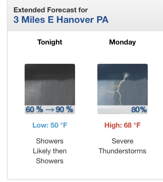
That’s for Hanover I’m talking Lwx
-

3/16/26 Severe Weather Event Thread (Day 2 MOD Risk)
wxmeddler replied to Kmlwx's topic in Mid Atlantic
FOLKS Exceptional Synoptics call for exceptional care, and in the equinox seasons if you've got big numbers on the cold side, you should be prepared for big numbers on the warm side. This system is no exception. CAM guidance from this morning's 12z runs show a variety of scenarios and evolutions. When in doubt about storm mode or coverage, falling back on the synoptics is usually the best forecast. In this scenario, the synoptic evolution is clear. A large mid-latitude trough exhibiting two distinct mid/high level wind-maxima rounding the base of the trough is creating a primary low through the upper mid-west while the secondary (later) wind maxima emerges over the southeast and quickly ejects through the Mid-Atlantic. Ahead of this second wind maxima large scale ascent through upper-level divergence will cause mass flux response from the Carolina's northward into southern PA. As the secondary wind maxima / embedded trough tilts negative an area of lower pressure will develop east of the blue ridge in the Piedmont region of North Carolina and quickly traverse northward. Along this embedded low, guidance that has taken this solution has backing wind vectors in the lowest 1km relative to the Bunkers right motion. This produces large curvature hodographs in the lowest 1-2km's followed by a storm relative weakening in the mid-levels, with exceptional ventilation in the upper levels. The kinematics from the Blue Ridge to about the US301 corridor from North Carolina to the M/D line in our region are exceptional. Storms that form ahead of the main pre-frontal line that exceed 30kft tops or start producing significant amounts of lightning will be capable and likely will produce long-tracked significant tornadoes. A violent (EF-4) level tornado cannot be ruled out either if instability increases due to pre-frontal warming / breakout sunshine. Storm motions will exceed 50kts and while potentially photogenic, will be un-chaseable except for those who position themselves ahead of the storm 20-30 miles in advance. The highest risk will be from about noon in North Carolina Piedmont to about 7pm in Southern Maryland. Storm coverage in this area ahead of the main pre-frontal trough / squall is uncertain and will have to wait till tomorrow morning to see what debris / storm outflow from the ongoing convection off-shore of South Carolina brings northward. For the pre-frontal squall line: Embedded supercells that produce narrow corridors of 60-80 mph winds seem likely in RFD regions. Especially storms that form ahead of the squall line and get absorbed / merged in with the squall line have the potential to produce strong gusts. Power outages in these narrow corridors (3-5 mi wide) could be substantial. The lack of leaf out on the trees up our way will be beneficial, still, the strengths of the gusts in the enhanced regions will be enough to down branches onto lines. Given the unseasonable cold of the airmass behind the cold front, warming shelters and means of finding warmth Monday into Tuesday as power is restored will be of concern. If I have time this evening, I'll do a historical perspective and get some analogs. -

3/16/26 Severe Weather Event Thread (Day 2 MOD Risk)
Eskimo Joe replied to Kmlwx's topic in Mid Atlantic
Lee surface low would make this legit MOD risk for tor/svr winds -
3/16/26 Severe Weather Event Thread (Day 2 MOD Risk)
Eskimo Joe replied to Kmlwx's topic in Mid Atlantic
Welp.... -

3/16/26 Severe Weather Event Thread (Day 2 MOD Risk)
konksw replied to Kmlwx's topic in Mid Atlantic
So is the wedge what could limit severe risks if it hangs on? -

3/16/26 Severe Weather Event Thread (Day 2 MOD Risk)
snowfan replied to Kmlwx's topic in Mid Atlantic
-
I’ll give it a B-. It was good in that we got SOMETHING however some of it was wasted on the cold and not much happening around here anyway.
-
South wind really started picking up in the last hour. Gusting between 40-50 mph. Temp is up to 64.
-

3/16/26 Severe Weather Event Thread (Day 2 MOD Risk)
EstorilM replied to Kmlwx's topic in Mid Atlantic
Yeah, but relatively speaking (for this scenario, and climatologically) this is plenty CAPE, probably 750-1000. Don’t really need the CAPE when you’ve got so much else going for you, so not a typical HSLC setup where that would be a limiting factor. -
Just 13 days away at the end of March….and on an operational model….what could possibly go wrong?? Lol