All Activity
- Past hour
-
Mostly sunny here now
-
68/67 +SHRA Nice tropical downpours in these showers.
-

E PA/NJ/DE Summer 2026 Obs/Discussion
LVblizzard replied to PhiEaglesfan712's topic in Philadelphia Region
Wind is absolutely howling right now. If it’s not wind advisory level, it’s very close. -
Bahama blues here. Great looking satellite out ahead of this stuff. Have to wonder though if that mid-level dry air moving in will really hurt, despite the building lower CAPE
-
Congrats those north of the MA/CT line; limited rain over night and marine layer from southerly winds going to hurt my area
-
Just got my 80 ... 80/67 rustling breeze with cracker alto strata and a few scud shred moving swiftly underneath. Intervals of sun. Actually feels like an tropical island morning.
-

Summer 2026 Med/Long Range Discussion
CheeselandSkies replied to Brian D's topic in Lakes/Ohio Valley
...and nearly all of them have been south of I-80/definitely 88. The exception on 4/17 I didn't chase...assumed everything would be HP and it was...except when Harrison-Rockton briefly popped out of the rain and was gorgeous. My only tornado this year is in Minnesota of all places, on April 13. Sandwiched between driving back from my tour which ended in OKC on the evening of 4/12 and nearly wrecking my car chasing 20 miles from home on 4/14. -
We're taking the father-in-law up to Road America on Sunday. Long-range NAM has a rainout... but it's on an island, and it's long-range NAM, so taking with a giant grain of salt. Most of the rain should stay south
-
Turned mine off today. Best climo
-
seems sketchy here. temp went up, DPwent up, and pretty breezy. now in a downpour. Hold me.
-
Have to watch for rapid destabilization out ahead of the line given the sky conditions and rapid jump in temps...may have a similar affect to parcel acceleration that you would see with steeper lapse rates because the air is becoming less buoyant rapidly.
-
You gotta be careful with TVS in setups like this with very strong shear. I don't think Radarscope does this but these are probably elevated TVS signatures...so there are probably 2 or 3 bins (forget the minimum requirement...think its 3) on successive scans meeting shear threshold and above a certain distance above the ground.
-
This could be fun... we clearly have a warm frontal thrust/wedge now up to EEN and we're opening the skies to sun. Temp popped 4-6F in the last hr west of ORH up through FIT and across my region. 79/67
-

2026-2027 Super El Nino
bluewave replied to Stormchaserchuck1's topic in Weather Forecasting and Discussion
Yeah, I wouldn’t be surprised if the Euro increases its ONI Nino 3.4 forecast plumes a bit more with the coming July 5th update. -
yeah SPC mentioned 'low top' in their coverage. I suspect they went tor out of respect for the llv jet in the area.
-
Decent destabilization going on ... 77 to 80 suddenly with 66 dps. Sun splashing and a nice llv S jet wobbling the trees. any thunderstorms rollin into this will be set up with +helicity
-
Nothing is really standing out in terms of rotation. OF course much of this stuff is in some awful radar coverage but going up a tilt or so, nothing is really impressive so a sign anything llvl is probably minor as well. Don't think there is enough instability right now to really get something spinning. May actually have to watch into Berkshire County...some higher sfc vorticity there per mesoanalysis with increasing 3km Cape.
-
try cologne mostly sunny and quite windy here, about as windy as this wind pit ever gets
-
Saw it earlier looked good
-
-
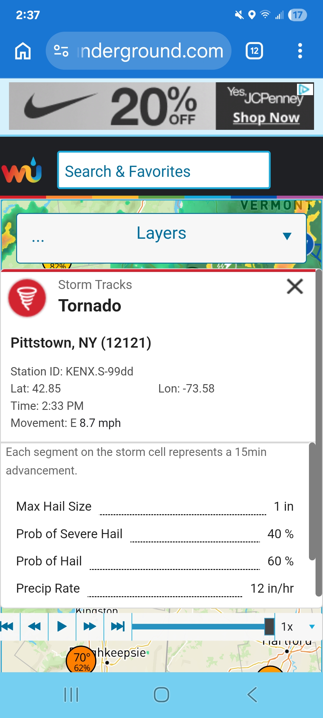
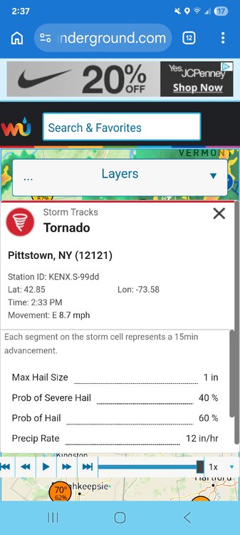
From this?
-
And we still have a lot of 1-scan wonders from DVN to pad the total with during derecho season coming up.
-
cells firing east or the Berk as the airmass begins to destabilize and MLCIN has eroded.
-
Almost a half inch in 15 minutes as the line came through. Just over 2” on the day.
-
Maybe you should go look at the drought monitor map. Most of our area is now in a severe drought. Obviously you're not a farmer or gardener so you don't understand how rough these conditions are.