All Activity
- Past hour
-
Looks like maybe another 8 hours or so to go depending on how fast or slow it's moving!!
-
When the AIFS and Euro get close to a similar solution...that is a good thing. Very slight trend south on the 18z Euro...50 miles? Looks like maybe some coastal backing to boot.
-
That Euro was the whole hog. 12+ most everywhere and still snowing.
-
I think it may be one of those situations where if you lose liquid further south you gain ratios as you go north due to very cold temperatures. Less liquid but with the cold higher ratios more snow pure powder.
-

January 25/26 Jimbo Back Surgery Storm
NYweatherguy replied to Jimbo!'s topic in Southeastern States
Looks like all sleet north of Atlanta. Still nasty. -
A good amount more I’d wager? The slower storm start means we’re only about 12 hours closer to game time than we were yesterday. lol
-
Euro doesn't include sleet/ice in its raw output data..unless host site algos it
-
I agree(you saw my post a couple pages back). 12z does actually eject significant energy from the SW, via a partial phase with the energy dropping south from the Pac NW. 18z doesnt, its flatter, but is slightly better with the silly snow maps. Ofc that's only part of the story- the timing/depth of NS energy associated with the TPV is another component.
-
Should be some more after that?
-
Here are two slides. The second slide is when the map cuts off.
-
So what is everyone general thoughts on the pattern is this one and done or could we have another system in February?
-

E PA/NJ/DE Winter 2025-26 Obs/Discussion
Ralph Wiggum replied to LVblizzard's topic in Philadelphia Region
If atmosphere has memory, which I do believe in similar tendencies, this will likely be another minor event like either last Saturday or Sunday, respectively. -
Oh I'd definitely be happy with that!!!
-
To my untrained eye, looks like maybe about 12 hours of snowfall to get thru after the 144 hour cut off. Unless I'm misjudging how far back precip is on the model at hr 144
-
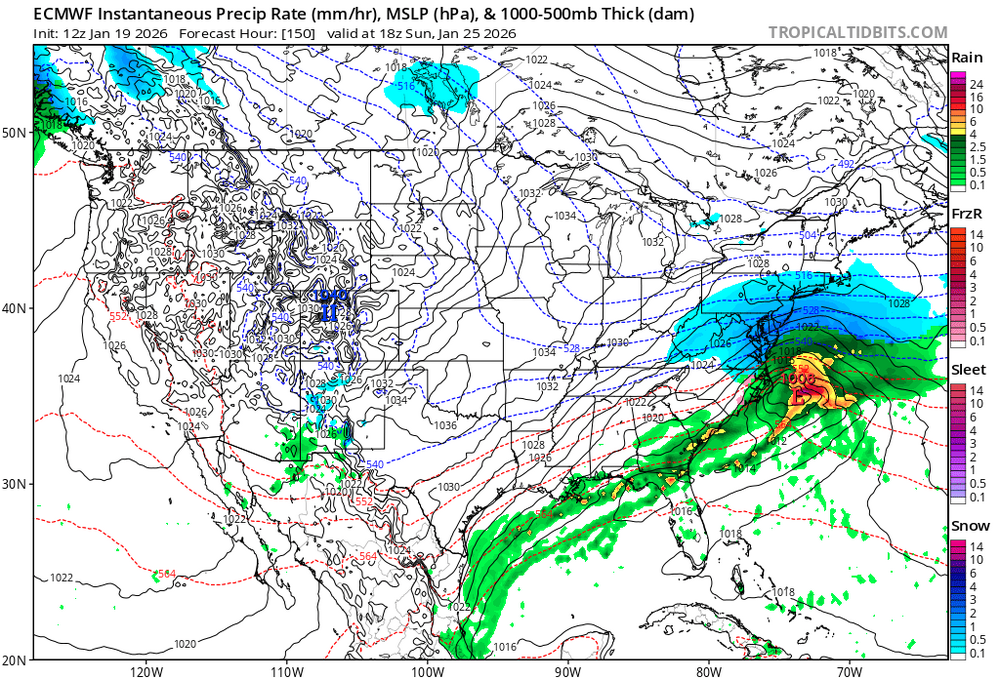
For reference, here's the 12Z 150h ECMWF valid at the same time. Notice how it's moving out by then but still left us in quite good shape. I'd say 18Z looked better with what appears to be a decent bit yet to come after 6-8".
-
That's crazy that it's still snowing lol
-
Soundings show it may be more sleet. There's a sub freezing layer from 875mb and below which often is deep enough
-
Imma go ahead and set my expectations to 6-10. I'm sold
-
And that's 10:1. I can guarantee you with the temps being modelled we will do far better than that. It's a foot region wide most likely.
-
I remember the MEI getting to something like -2.3 or something in 2022. I think that’s why that winter acted exactly like how I would picture a super Nina to act.
-

-
2025-2026 Fall/Winter Mountain Thread
CheoahBald1 replied to Buckethead's topic in Southeastern States
HR 144? It looked like plenty more was behind that? . -
Look what's coming in up top at 144hrs. That'll definitely enhance snowfall. I think with that High pressure puling off the NE coast driving in cold ocean air and that trough coming in, there will be a part 2 for us northern folks.
(9).thumb.png.ef756489110f269d8f2dd46a8627c5cf.png)
-
Does these maps include ice & sleet? Also that is 10:1 ratios. It will be higher than that. Maybe we all will get to say ITS PUKING SNOW!!!!
-
That's not even kuchera...12:1 to 15:1


(9).png.27826cf8e1c9ddf54bac7435e995b354.png)
