All Activity
- Past hour
-
 Look at that shade, must be a tree issue there as well
 -
For pure entertainment, a station that runs a bit hot up the street from me maxed at 100/86 yesterday for a 136 HI lol
-
Yesterday's high 94f. DP...don't ask. (was 80 actually) Starting out 4 warmer this morning at 75f. I could see making 97 today if no clouds form. We'll see.
-
EWR may have a 30 degree variance in highs today and Friday. 102 today / 72 or less Friday.
-
Yeah, nobody’s cheering on heat stroke any more than someone cheering on heart attacks in the wake of an 18-24” KU in January, but I digress.. I’m +3.5° compared to this time yesterday. Running 4° behind HFD right now but I’ll make up ground just as I did yesterday.
-
BOM http://www.bom.gov.au/climate/enso/?ninoIndex=nino3.4&index=nino34&period=weekly
-
The consoles sample variables at different time increments. So the dew probably changed from the time one console pinged it to when the other one did…just a guess. But I had 82° for a dew here as well. The Davis ones can become a little oversaturated with age, but we do get more pooled up moisture from evapotranspiration than wide open airports. But temp and dews actually change pretty rapidly with responsive equipment. Mercury thermometers have lag. These digital probes are almost instantaneous. That’s why ASOS uses running 5 minute averages to try to simulate the slower response of the mercury thermometers.
-
It is harsh on the body, no question. I don't know if "cheering" is the right word. I mean sure... there's always someone, but for most, it's the novelty of witnessing an extraordinary event. We nick 100 F on our big heat days, with enough frequency to numb us to the significance of 1-0-0. But getting a possibility for every site to be 101 to 104? mm that is definitely novel enough to the area to take note. It's a special anomaly ... it seems there may be an "air" ( pun hopefully annoying haha) of synergistic heat bomb about this, too. There are several factors that are likely propel this into the "rogue wave" territory - the New England version of it, today. One observation of note ... there was a peculiar temperature rise of 2 to 3 F at several home sites around the area, which took place at 2am, after we had settled off to 74-ish. Back up to 77... this happened well before the light rose during the bowls of deep dark night. And it continued to rice decimals per 5 minute click off through dawn. Now, 90 and 91s are common at 8:30. This is how synergy manifests. I don't believe the models are seeing these idiosyncratic positive feed-backs... Anyway, human curiosity takes over. There's also a ton of scientific significance to novel scenarios. But imho, I don't think the average observer of this is wantonly cheering on a injury - and if they are, they should be guided to jumping off the cliff first as their poetic justice.
-
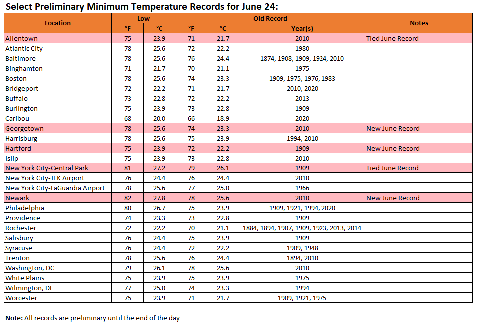
 Final low temperatures for yesterday and preliminary low temperatures for today:
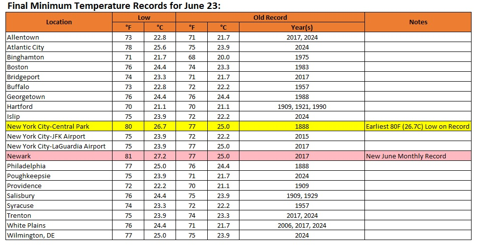
-
Wed - night / Thu
-
 You are correct. This is the first time that JFK reached 90° at 8am in June. So they could reach 100° before noon if the sea breeze can hold off. https://mesonet.agron.iastate.edu/plotting/auto/?_wait=no&q=153&network=NY_ASOS&zstation=JFK&month=jun&sday=0624&eday=1231&var=max_tmpf&_r=t&dpi=100&_fmt=png
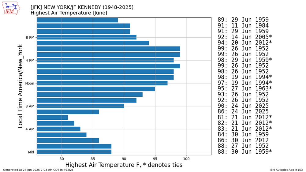
-
86.0
-
June wasnt that hot in 2013 it was a 2 day heat spike. The heat was concentrated in a 3 week period in July 7/4 - 7/23
-
Scattered lows 90s popping up on PWS sites before 8:30am impressive..
-
8AM: JFK: 90 EWR: 90 New Brnswck: 89 PHL: 88 ISP: 86 LGA: 86 TEB: 86 ACY: 86 NYC: 85 TTN: 83 BLM: ** nearest is 83
-
Yea, our climo this close to the ocean lags the solar calendar by a good month...which is why our cold peaks from about 1/20 to 2/1 and snowfall from about 2/1 to 2/10...right up to warm-tushy-car-seat season.
-
 Dewpoint down to a crisp 72, lowest since Sunday morning for me
 -
High of 71 means you know the dewpoint won't be any higher than that lol Considering I spent most of the day yesterday with a dewpoint near 80 degrees it's going to feel downright dry!
-
 Getting ready to make history today!
 -

Central PA Summer 2025
Mount Joy Snowman replied to Voyager's topic in Upstate New York/Pennsylvania
Looks like our relief should come the way of a potent little backdoor cold front that sweeps through Thursday evening. -
No idea. I run the old cosole. It's very reliable, not to say the digi one isn't, but mabe shoot Davis an email and ask.
-
 Low of 75 here. Upton has a high of 71 both Thurs and Fri here-that will feel great.
 -
It was me that reported that my Davis Vantage Pro 2 reported a 81.8F dew at 2:45pm. I questioned that because it just intuitively seemed too high. Unless you're in a cornfield out west, you just don't see dews that high. Then I discovered something just now. I have 2 consoles reporting off my 1 station but the new LED console is showing a dew 2F higher than my older Davis console in the other part of the house. So I was watching the new LED console. Why would 2 consoles report different dews off of the same station. All other parameters seem correct? Any ideas? In any event, I'm going to go with the old console. In that case, my max dew would have been 79.8F


