All Activity
- Past hour
-
And big dogs are very rare for us in Nina’s
-
Sunbathing wx. Lol! John always brings the positive lols.
-

December 2025 regional war/obs/disco thread
VivaManchVegas replied to Torch Tiger's topic in New England
GYX mentioned that models have a hard time handling CAD this morning. All eyes on how quickly the clouds move in or do not Sunday night. Cold snow pack and how much radiation cooling takes place before the clouds move in would seem to be a key item. We are supposed to hit 38 degrees here tomorrow. Eye on that as well. -

Winter 2025-26 Medium/Long Range Discussion
Cary67 replied to michsnowfreak's topic in Lakes/Ohio Valley
Getting that EC vibe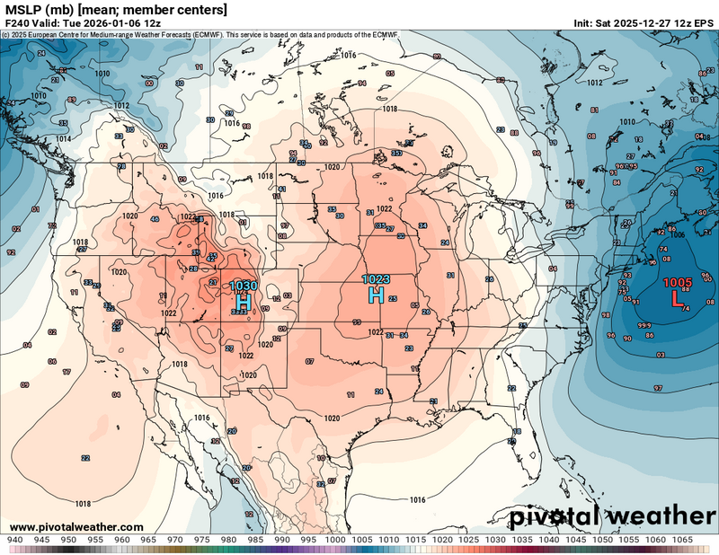
-
A few moderate ones, I’ll be ecstatic. Big Dogs are becoming very elusive and tales of lore
-
To me it has been a windy 2025. Glad I don’t wear a toupee. Lol
-

Winter 2025/26 Banter Thread
SouthOaklandCtyWX replied to Chicago Storm's topic in Lakes/Ohio Valley
I consider a “big dog” to be at least 12”. That’s just my definition and I feel like that’s been reported more in areas out near the hills in DTX’s CWFA. Obviously storm track plays a major role too and DTW can end up with more snow than DTX if it takes a more southernly Miller B track. -
Bipolar weeklies at that.
-
Middletown is a funny case. For the Tue event the NWS hoisted a last minute WAA and the area ended up with warning snows. For this relatively long lead WSW event, I believe that area ended up in the upper tier of advisory snows. Snow is very difficult to accurately predict.
-
We did half yesterday & the rest today. Time to enjoy some R&R but also try to kill a mole or moles in my yard. Also do paperwork. Owning my own business means end of year taxes. Which my brother the CPA is asking for lol.
-
Im so frickin jealous of the UP. They are going to get crushed with this blizzard. At least the snow base will be building up for when I go in mid February. Been a while since our region has seen such a wound up storm...perhaps a good sign for the lower Lakes at some point in January or February?
-
I dunno if anything will happen but IMO the early-Jan pattern is kinda similar to the ones present in DCA to BOS major winter storms. +PNA looks to show up. So does a west based -NAO. And the STJ is actually alive for once, which IMO has been the piece we've been missing for the last few years. The PV is on our side of the world, so we can tap into cold air very easily. It's pretty rare we see that combo. We just need that pacific to be a little bit better and then there's real big dog potential. I'm liking this January 2026 look better than January 2025 solely because we have an STJ. Hopefully we can reel a big one in, or maybe we'll just flop on our faces after the NYD clipper lol
-
good question, but heating systems are more efficient today. intresting is that a mechanic told me today's boilers and furnaces are only good for about 10 years; he said its not your dad's old furnace that lasted 40 years....
-
Couple minor comments: on the 18z NAM snowfall map I looked at on pivotal at 10:1, Islip was 5.0, NYC was 2.6, and Newark was 0.8. But the colored graphics look wonky - I'm not sure how accurate they are. Point and click shows about 2" for Newark. It shouldn't be much different than MMU considering their relative lat lon positions. Secondly, I don't believe those numbers count sleet. I believe the algorithm ignores accumulated sleet and only displays the snow equivalent. So some sleet accumulation (NYC and EWR) would lead to underestimation. Since snow accumulation is a very inexact metric to both forecast and measure, I don't believe a subset of reported snow totals is a good method to assess model verification.
-

Winter 2025-26 Medium/Long Range Discussion
michsnowfreak replied to michsnowfreak's topic in Lakes/Ohio Valley
Weeklies continue to have average to below avg temps all of January. -
Those aren't big dogs though. But that is the huge perks of the m59 north area of especially Oakland County is their elevation and the fact that they will snow when everyone else rains or they will get high ratios ie bigger amounts in borderline temp events.
-
I don’t post a lot of tweets, but this saves me from having to cut/paste the analogs and allows me to source the information all in the same post…this is from MA thread.
-
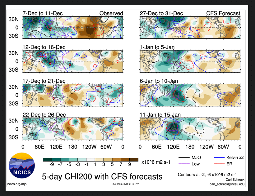
Kinda like wash rinse and repeat,with Rossby and Kelvin Waves along with the standing wave in this regions for months it seems close to the MC
-

December 2025 regional war/obs/disco thread
TheSnowman replied to Torch Tiger's topic in New England
Can we talk some December 31-January 1 Potential Please? This next one is Totally worthless to us in the South. -
Your wisdom is impressive. A lot of bullish hype in here this afternoon but I believe most don't understand or admit how difficult serious Drought is to overcome. That southern jet needs to be on steroids..............................
-
Positives. The AH dies. There's a bit of a -NAO. There's no SE ridge. The STJ is waking up a bit, maybe. The cold isn't so suppressive that we are seeing Florida beaches getting buried. The polar vortex may get stretched again in January. For the next two weeks we will have a pattern more conducive for snow than our current pattern of sunbathing weather. The two weeks after that, may, (stress may as always here) be even more conducive. Especially if we get the +PNA to show up, timed with a wave. @GaWx noted that even for areas East of the Apps, the +PNA was the most frequent teleconnection for decent snow events. I'm hoping we also continue the trend he noted of +PNA January conditions that follow -PNA Decembers.
-
Winter 2025/26 Banter Thread
SouthOaklandCtyWX replied to Chicago Storm's topic in Lakes/Ohio Valley
Being further north helps but a big part of it is also because of the glacial moraine system. Seems like the cutoff for the “big dog” the past few years has been around M-59 and even more so towards I-696 where elevation drops below 700 feet. I always like watching the webcams at Pine Knob, Alpine Valley, and Mt. Holly, have been several times where it’s snowing on their webcams yet it’s rain/sleet or a dry slot at my place in Royal Oak. -

2025-2026 Fall/Winter Mountain Thread
CAD_Wedge_NC replied to Buckethead's topic in Southeastern States
Learned how to swim in the south Toe river when I was 8 years old. Seen plenty of big trout come out of that river. -
Cautiously optimistic heading into January. The addition of potential southern stream is what you want to see for better potential in these parts. Blocking plus southern stream opens the door for more appreciable storms. Plenty to like about the latest ensembles, but it’s still D10-15, so don’t throw all the chips in just yet. Will be something to keep an eye on and track as we move into 2026.
-
December 2025 regional war/obs/disco thread
Not me in VT replied to Torch Tiger's topic in New England
I've been lurking in here for 15 years now, Other than Mount Tolland is this ice something to be worried about in SV? . These model outputs seem to be always overdone or is this time different? Stand by power business planning purposes, Thanks for the help all, Happy holidays.


