All Activity
- Past hour
-
I feel like i need to meet up with you at either A . North Wilkesboro B . The 600. Have fun at Daytona!!!! .
-
Legit SN+ on top of Keysers Ridge before the squall. Reports upstream were 2-3” in 45 min. This is gonna be wild.
-

February 2026 Medium/ Long Range Discussion: 150K Salary Needed to Post
LP08 replied to Weather Will's topic in Mid Atlantic
What’s worse…no storm or another Carolina crusher in the CMC -
KJKL radar looks pretty juicy. Delayed but not denied.
-

Pittsburgh/Western PA WINTER ‘25/‘26
colonel717 replied to Burghblizz's topic in Upstate New York/Pennsylvania
My yard was nothing but deer tracks, now it looks great again thanks to the wind. -
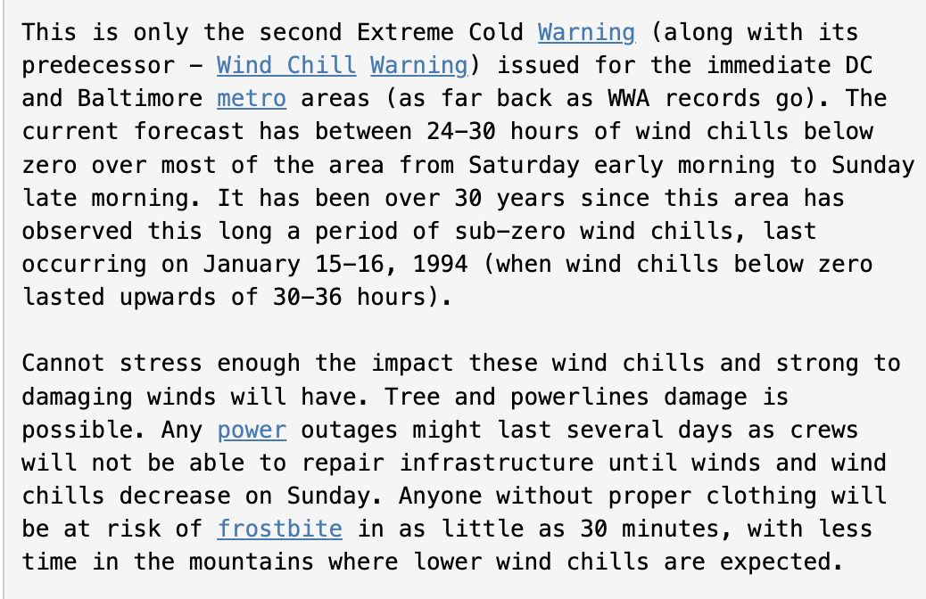
Pretty extreme wording for tonight

-

Pittsburgh/Western PA WINTER ‘25/‘26
Rd9108 replied to Burghblizz's topic in Upstate New York/Pennsylvania
Fine with me. Let's get this total above average. -
we're getting 500:1 ratios. moon dust stuff. We only need like 50 flakes
-

Friday February 6 FROPA / WINDEX small event
40/70 Benchmark replied to HoarfrostHubb's topic in New England
This MOFO wants to snow...look out tomorrow. -

E PA/NJ/DE Winter 2025-26 Obs/Discussion
RedSky replied to LVblizzard's topic in Philadelphia Region
At some point I had a snow shower hit me up with .20" -
Pittsburgh/Western PA WINTER ‘25/‘26
colonel717 replied to Burghblizz's topic in Upstate New York/Pennsylvania
They had .8 from the earlier. They may get in more. -

February 2026 Medium/ Long Range Discussion: 150K Salary Needed to Post
Ji replied to Weather Will's topic in Mid Atlantic
Unusable -
The Polar front? Most definitively, the snow squall up in PA?... eh.. maybe a few flurries.
-
Pittsburgh/Western PA WINTER ‘25/‘26
Rd9108 replied to Burghblizz's topic in Upstate New York/Pennsylvania
Add it to the total boys and girls
-
Pittsburgh/Western PA WINTER ‘25/‘26
colonel717 replied to Burghblizz's topic in Upstate New York/Pennsylvania
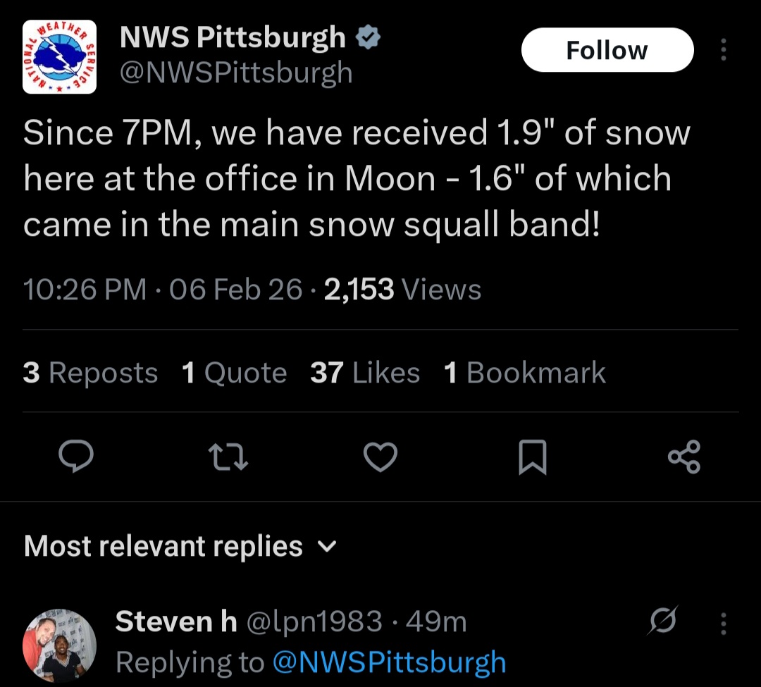
Just had another one come thru. Thought we were done, but that long squall gonna lay down an inch whoever gets in it. I need it to drift east a few miles. More building behind it. -

Friday February 6 FROPA / WINDEX small event
metagraphica replied to HoarfrostHubb's topic in New England
Yep, impressive snow growth and rates. Easily a half inch already. -
11 if you include the three different marine hazards
-

Pittsburgh/Western PA WINTER ‘25/‘26
Mailman replied to Burghblizz's topic in Upstate New York/Pennsylvania
Didn't last more than 10 minutes, but it was pretty good. Got a streamer heading in this direction. See how that ends up. -
Wow 8 different colors on one map at the same time lol
-

Friday February 6 FROPA / WINDEX small event
nutmegfriar replied to HoarfrostHubb's topic in New England
Almost an inch already on the Chester/Deep River line with moderate snow -
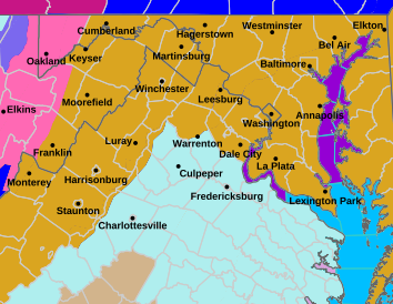
LWX hazards lit up like a Christmas tree, lol. Snow Squall Warning Heavy Freezing Spray Warning Winter Storm Warning High Wind Warning Storm Warning Gale Warning Extreme Cold Warning Winter Weather Advisory Cold Weather Advisory Wind Advisory Freezing Spray Advisory Low Water Advisory Extreme Cold Watch Special Weather Statement Air Quality Alert Hazardous Weather Outlook all active somewhere in the map
-
 Don't even look at it yall
 -
Need this squall line between hagerstown and frederick to hold together over south mountain
-
Pittsburgh/Western PA WINTER ‘25/‘26
colonel717 replied to Burghblizz's topic in Upstate New York/Pennsylvania
I really thought it was going to just miss us. But it didn't disappoint.