All Activity
- Past hour
-
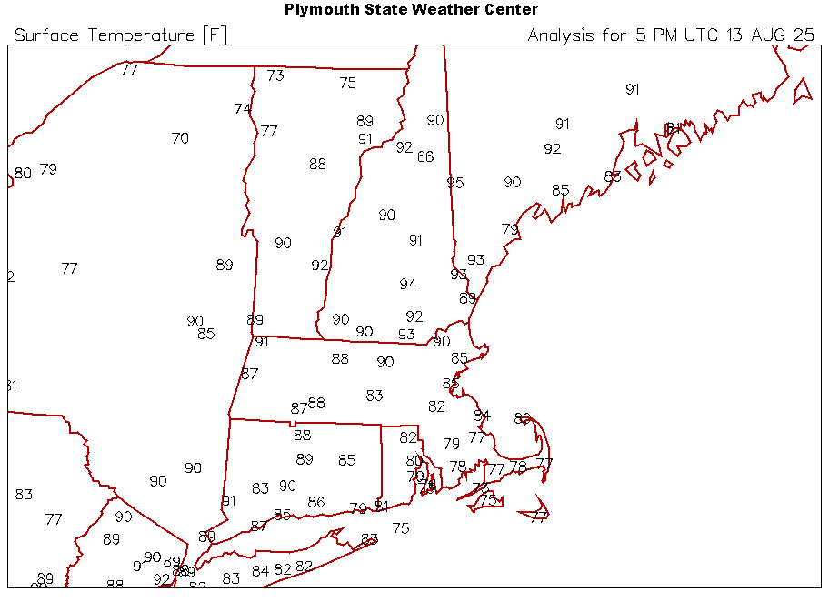
Caribou has reached 90F (32.2C) for the fourth consecutive year. That ties the record for most such consecutive days. The record was set during June 15-18, 1949 and tied during July 25-28, 1963 and August 29-September 1, 2010.
-
I went outside last night at 1am and watched for an hour. As expected, it was nothing like last year's show due to the bright moon. The moon was in the part of the sky in which I saw the most meteors last year. It really ruined the show .... I only saw a few faint looking ones. I'm looking forward to the Geminid meteor shower in december. The moon won't be an issue so that should be by far the best meteor shower of the year. Hopefully we'll have clear skies for it. I don't care about being out there in colder weather as long as it's a nice show.
-
WFUFamily started following Tropical Storm Erin - 45 mph - W @ 20
-
Almost no rain the last few weeks. We went from flooding to an extremely dry ground here. I'm having to water the vegetable garden almost every day. As Stormlover said, today's activity will be hit or miss. I'm really hoping we get a heavy downpour today, but I'm heading down to Seaside Heights so I won't be here to see it if it happens.
-

2025 Atlantic Hurricane Season
BarryStantonGBP replied to BarryStantonGBP's topic in Tropical Headquarters
Bro, does this mean the next 3 NS are likely weak? I give up if the funniest name is wasted -

Tropical Storm Erin - 45 mph - W @ 20
WxWatcher007 replied to BarryStantonGBP's topic in Tropical Headquarters
Newfoundland in particular. They’ve been getting either glancing blows or direct hits sporadically on the op Euro and GFS. -
12Z UK: for several runs has had this after Erin: NEW TROPICAL CYCLONE FORECAST TO DEVELOP AFTER 156 HOURS FORECAST POSITION AT T+156 : 15.9N 24.3W LEAD CENTRAL MAXIMUM WIND VERIFYING TIME TIME POSITION PRESSURE (MB) SPEED (KNOTS) -------------- ---- -------- ------------- ------------- 0000UTC 20.08.2025 156 15.9N 24.3W 1010 28 1200UTC 20.08.2025 168 15.7N 28.1W 1009 32
-
91.1 at home along with dews…
-
-

Tropical Storm Erin - 45 mph - W @ 20
olafminesaw replied to BarryStantonGBP's topic in Tropical Headquarters
The GFS is trending a bit towards a trough capture. Certainly too late for a New England landfall, but brings Atlantic Canada back into the conversation -
Mid-Level Vort Energy would be a great band name.
-
Hope that rain makes it. Has not rained in weeks in my backyard....
-
89.6° MPM heat wave currently edit 90.1°
-
Gorgeous humidity today. Looks like a swath of rain to the west, but will it get here? That’s a tall order based off the current steppe conditions.
-

Tropical Storm Erin - 45 mph - W @ 20
wthrmn654 replied to BarryStantonGBP's topic in Tropical Headquarters
Of oddity, the euro AI and the icon have nearly identical low placement at 00z thursday hour 180... How did AI models do last hurricane season? ? -
models are not particularly impressive for this afternoon, but none seem to have a good handle on the evolving area of widespread, heavy convection to our west. Radar is quite impressive.
-
another ridiculous flood watch posted by LWX this summer. Expecting <.25 in
-
88.2 at my house. Should squeak in the 90 for a minimum heat wave.
-
The Latest HRRR says what rain.
-

2025 Atlantic Hurricane Season
BarryStantonGBP replied to BarryStantonGBP's topic in Tropical Headquarters
-
Now know the ICON is not a tropical model Ensembles are all in agreement. A swing and miss...no extra innings for this baby! NEXT
-
~25 total ACE for those 3 progged storms, combined
- Today
-
And I'm hearing thunder, a bit east of New Milford, CT. Looks like a small blip on the radar, but I'm a happy camper. Nice little wind burst ahead of the rain getting here. The rain has arrived, nice little summer downpour - the lightning strikes have all seemed to be pretty anemic, though.
-

2025 Atlantic Hurricane Season
BarryStantonGBP replied to BarryStantonGBP's topic in Tropical Headquarters
How much ACE would that be between storms I give up. The funniest name wasted


.thumb.png.2e8341f06c6c8b4bcf2ef4289dda8754.png)


