All Activity
- Past hour
-

2026-2027 Record-breaking El Nino
mitchnick replied to Stormchaserchuck1's topic in Weather Forecasting and Discussion
Not 1 seasonal at any time as far as I can recall had anything but a solid AN for December. The change, if it's coming, would be/start sometime in January. -
Thanks for that info PF – it’s really interesting to get the perspective from someone who’s been living the experience. We’ve certainly heard about the short-term rental issues but had no idea how much it had changed things in your immediate part of the village!
-
Looks like its snowing at the higher elevations up here right now, Pretty chilly here too with -RN, 39/38°F.
-

2026-2027 Record-breaking El Nino
GaWx replied to Stormchaserchuck1's topic in Weather Forecasting and Discussion
It’s not a matter of “if” because it’s a certainty. Also that favors E US warmth in December as @snowman19has emphasized. Dec of 2015, 2006, 1987, 1982, and 1957 were all mild in the E US (other than 1957 being NN in the SE). -
One of the SC tornadoes (Barnwell) has been upgraded to an EF-2: https://x.com/Gio_wx/status/2109995279244026310
-
Yeah it's pretty comical
-
The tornado outbreak across the Carolinas was unusual not just for a TC-associated outbreak, but for the time of year: https://x.com/GMengel/status/2109798674465198505
-
Presently the Green Mountain spine, Franconia Notch, and the Presidentials are covered. I do plan to expand to include the ADK high peaks region however
-
This weather sucks I shouldn't be sweating on October 13.
-
2026-2027 Record-breaking El Nino
GaWx replied to Stormchaserchuck1's topic in Weather Forecasting and Discussion
Thanks! I just got on my PC and can see the updating table. For whatever reason, when I do it on my phone, it requires a download of the data. I do t get why they can’t have it more accessible like for the PSL link. Anyway, this NOAA 30 mb update for Mar 26+ is following the general pattern of the ATMOS Hub values along with the sometimes slightly faster transition to positive phase in addition to sig. higher amp on both ends as I mentioned. So this essentially confirms what ATMOS Hub showed us. Therefore due to the easier access to the ATMOS Hub data on my cell, I’m probably going to use ATMOS Hub at least as often as NOAA’s now harder to see on cellphone data. Plus I like ATMOS’ excellent graphic showing the entire atmosphere and how it progresses with the QBO cycle possibly even during mid month thus giving us a little bit of heads up that the monthly tables don’t show: CPC vs ATMOS (rounded) Mar -17 vs -31 Apr -9 vs -7 May -2 vs +6 June +4 vs +8 July +9 vs +13 Aug +11 vs +12 Sep +13 vs +18 -
I have been out of town for the last week....I am sorry to hear this, Carver...my condolences to you and your family.
-
Yeah it's always been November but I kinda expected more of a ramp up. Maybe that was a false expectation
-
Maybe a SYR special today? Sucks instability on Friday will be limited because those are some insane dynamics and a vigorous shortwave approaching. Maybe get a risk for some strong storms along the coast where dews could sneak into the lower 60s.
-
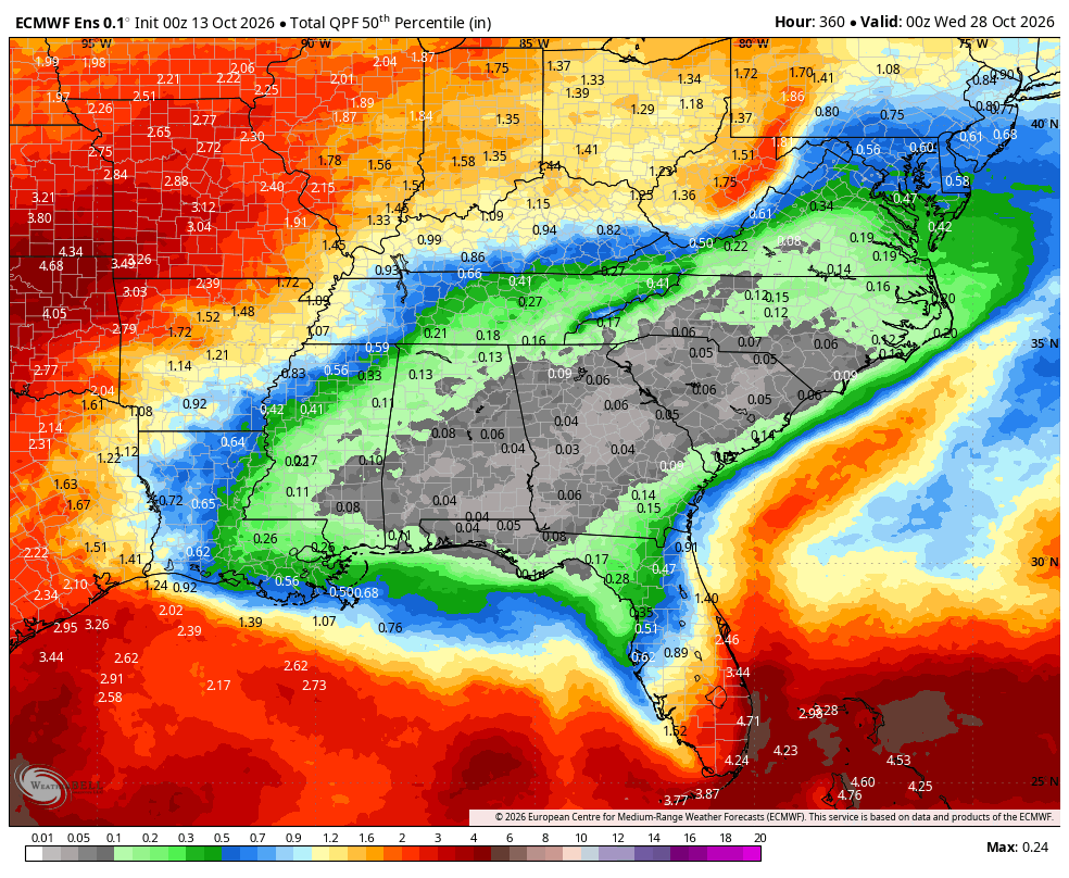
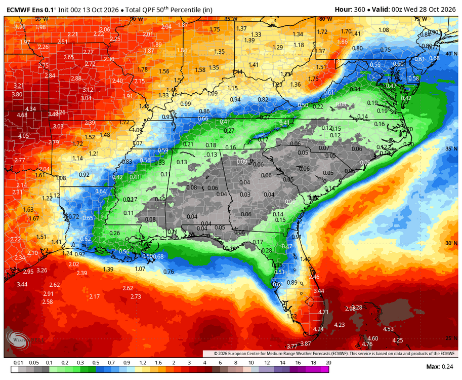
Thanks 1. It being the driest time of year means it isn’t all that unusual. 2. Oct is typically too early for the Nino STJ moisture as that usually doesn’t get going til close to Nov or often not til Nov, itself. That’s what the Euro Werklies are suggesting.
-
come to think about it ... sudden potent short duration events have also been increasing in frequency every time Gretta sneezes so heh
- Today
-
Friday could be interesting. Wind fields are strong. It's not out of the question there could be some strong winds if tstms form. Instability overall is lacking, but it is a dynamic system. The CAA winds Saturday diminished some. Still could be 40 to maybe near 50mph.
-
i'm always a little suss about those fast moving cold slicing waves like that. often enough they prove to have been over amplified. but like Scott just noted ... the ambient polar boundary appears to be gradient saturated so maybe this time we'll yo-yo 36 deg spanning 30 hours.
-
So Philly 0 to 3 but we get 24+?
-

E PA/NJ/DE Autumn 2026 Obs/Discussion
JTA66 replied to PhiEaglesfan712's topic in Philadelphia Region
Clear skies with filtered sun, but a light, misty fog has rolled in. 54F -
I dont know if Ive ever seen an ensemble that dry for that long. GFS is practically rainless across the SE for the entire run. Where is our Nino STJ? We got very lucky to get the tropical system, most all the region got at least 1" of rain especially worst drought areas
-
Tstms near BTV today and snow in nrn ME.
-
Looks pretty chilly to me.
-
Thanks man. Long story short, I wasn't doing anything weather related at the time and my team all got let go, so I am looking to get back into it to some degree. In the meantime, I also am going for my CCM (Certified Consultant Meteorologist) certificaltion through the AMS.
-

2026-2027 Record-breaking El Nino
LakePaste25 replied to Stormchaserchuck1's topic in Weather Forecasting and Discussion
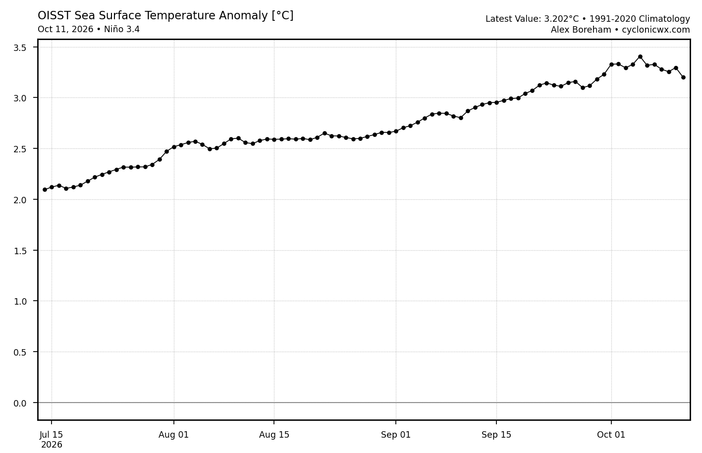
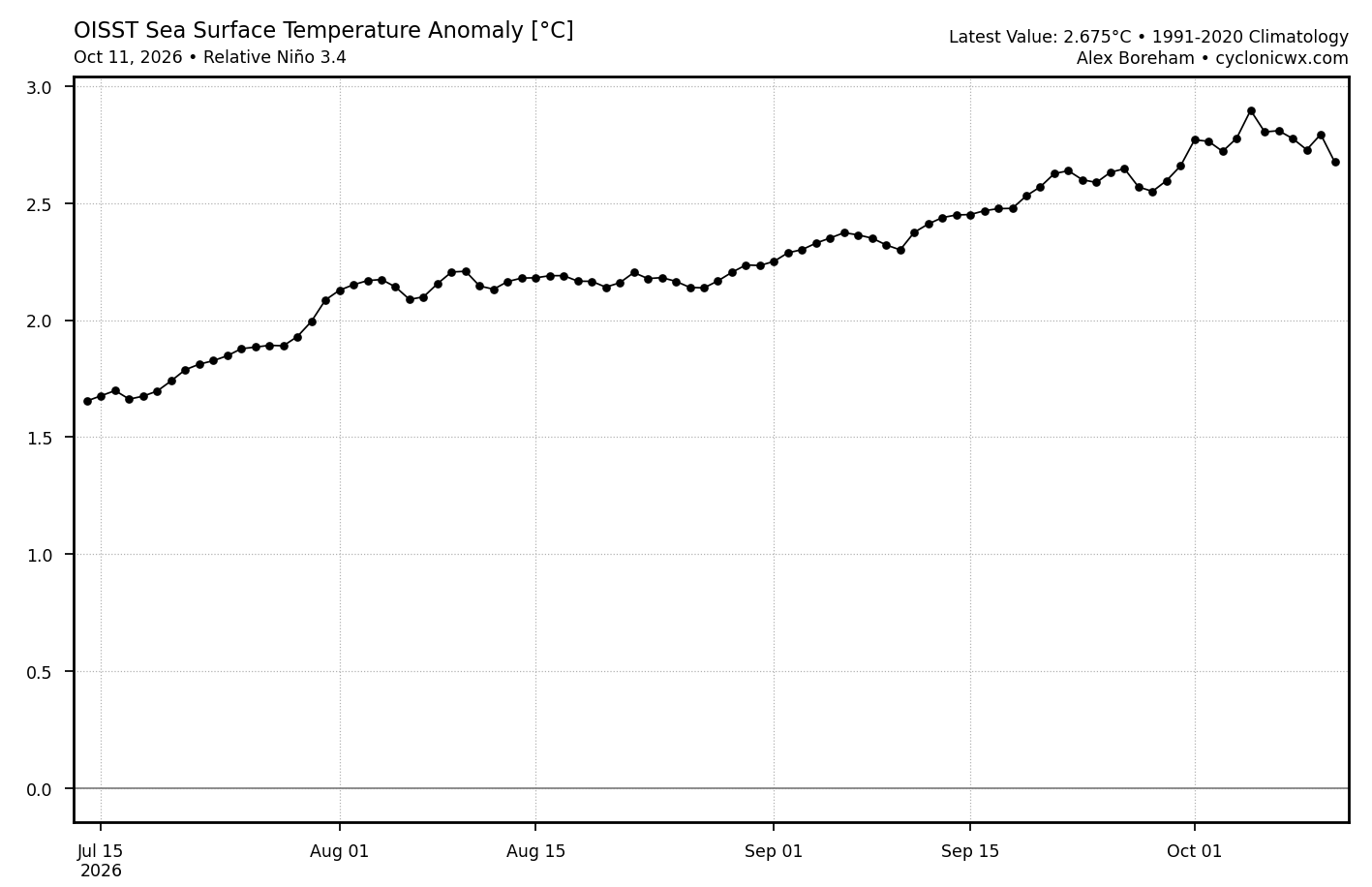
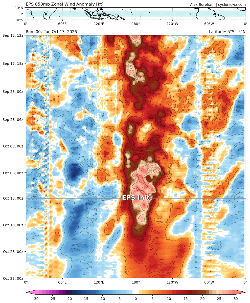
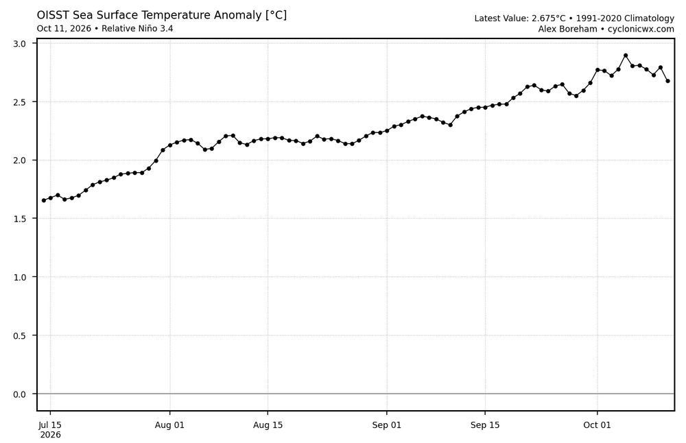
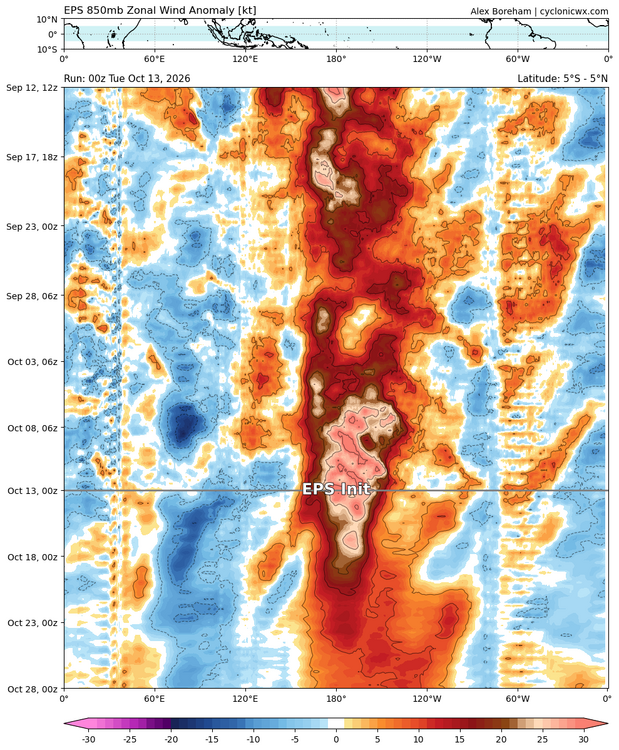
Typical short-term temporary drop of 3.4/r3.4 due to the evaporative cooling induced by strong WWBs. Once that settles in a week or two, they should start shooting to the moon again.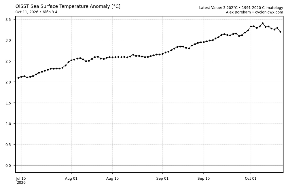
-
I noted those stronger winds in my posts as it was making landfall. You could see it on radar velocity very easily. But this all makes sense now. Pretty cool stuff.