All Activity
- Past hour
-

Late February/Early March 2026 Mid-Long Range
SnowenOutThere replied to WxUSAF's topic in Mid Atlantic
By rug pulls I mean the storm itself disappears. Personally, I am hesitant to think this will be a major snowstorm especially for where I'm at. If I was up in NOVA I'd be a bit more excited though still waiting. -
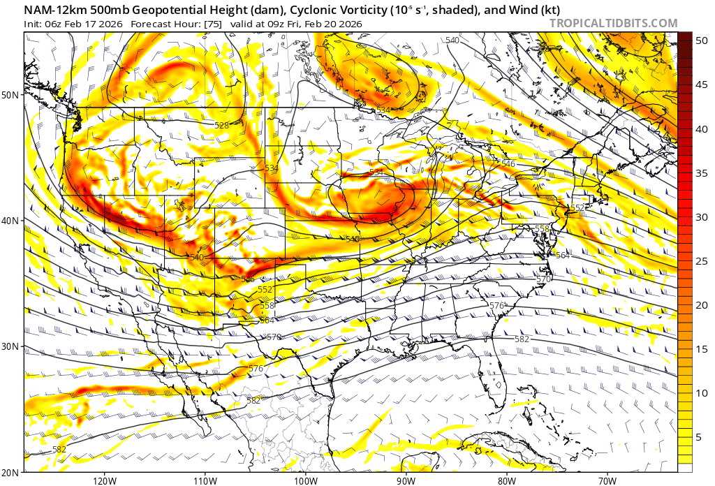
I know it’s just the NAM but, I think this is what we wanna see.

-
Both AI’s have a massive hit, not sure about their ens, Legacy GFS hits but kinda grazes, GEFS looks pretty good, Legacy Euro doesn’t like it, but ens have it. Ukie with an all timer. Did I miss anything?
-

Wednesday Feb 18 Mixed event. NoP refresher?
ORH_wxman replied to HoarfrostHubb's topic in New England
3k was run out of our basements. Narrow high end advisory type stuff right near and just south of pike in eastern areas. -
anybody have snow maps for the AI GFS and AI Euro 6z runs?
-

Late February/Early March 2026 Mid-Long Range
WesternFringe replied to WxUSAF's topic in Mid Atlantic
The 6z Euro just gave me 2". -

Wednesday Feb 18 Mixed event. NoP refresher?
weatherwiz replied to HoarfrostHubb's topic in New England
Yup...going to be a tough one. Just like you said, probably be a very narrow area that may do well. -
Fairly significant dip coming up.
-
.thumb.png.4150b06c63a21f61052e47a612bf1818.png)
Wednesday Feb 18 Mixed event. NoP refresher?
HIPPYVALLEY replied to HoarfrostHubb's topic in New England
It’s going to snow pretty good for a few hours along a narrow strip. -

Winter cancelled/uncancelled banter 25/26
Stormlover74 replied to Rjay's topic in New York City Metro
Not feeling this weekend storm. I feel like we're done other than a fluke mid March storm -
I'm going to wait until Thursday/Friday until I can say that. February 2025 fucked up within 5 days.
-

Wednesday Feb 18 Mixed event. NoP refresher?
CoastalWx replied to HoarfrostHubb's topic in New England
Drier air working in below 700mb though. So it’s a battle. -

“Cory’s in NYC! Let’s HECS!” Feb. 22-24 Disco
Typhoon Tip replied to TheSnowman's topic in New England
This 06z mean is a bit of a reposition W compared to the prior 00z cycle. Along with the spread ( in particular) opening up with more members closer to the coast, does lean more ominous.. 06z EPS mean. Some deep members there and more of them pulling/morphing the pressure pattern w-nw tends to flag where the correction wants to go, an aspect that has been noted when using ens means prior to other events in storm climo
-
Have fun Santa, as always ….

-
Rev, grey hat and Chuck over here talking about rain

-
Wednesday Feb 18 Mixed event. NoP refresher?
weatherwiz replied to HoarfrostHubb's topic in New England
I wonder if this energy diving in is the make or break for multiple inches of accumulation. This is some pretty decent shortwave energy diving along with a rapid increase in the lapse rates so it becomes fairly unstable aloft. This also would support sort of a re-blossoming of precipitation downstream of it.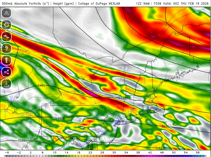
-
Late February/Early March 2026 Mid-Long Range
SnowenOutThere replied to WxUSAF's topic in Mid Atlantic
Been studying for my test today in 30 minutes so haven't been paying too much attention to the models but this sums up my thinking. Besides the December and one January storm every other setup seemed more likely to fail than not. Honestly, I've checked out of tracking since Jan 25th because nothing ever showed likelihood even close to that! This is the first storm since then where everything checks out. The models are bouncing around but never too far from a snowstorm, the pattern itself checks out, and its unlikely that it completely rug pulls. Will be paying more attention throughout the rest of the week. -

E PA/NJ/DE Winter 2025-26 Obs/Discussion
PhiEaglesfan712 replied to LVblizzard's topic in Philadelphia Region
My top analog is 2/26/2010. Feels like a last hurrah (after a brief warm-up), and I think this will miss just north, with NYC having a historic snowstorm, while PHL gets 4-6 inches, and BWI/DCA gets close to nothing, as the winter is pretty much over in those cities. -
heh... the crack addict will always pack the higher dose
-
I'm sorry if I caused anyone any great consternation with my stark realism. No malice was intended. Cheer Up! Most of the models seem invested for Sunday. But, its probably not wise to participate in any tail gate parties until Saturday.
-

Late February/Early March 2026 Mid-Long Range
winter_warlock replied to WxUSAF's topic in Mid Atlantic
Big improvement!!! Could we be seeing the king euro caving to GFS???? -

Wednesday Feb 18 Mixed event. NoP refresher?
qg_omega replied to HoarfrostHubb's topic in New England
Need a last minute north bump -
What.... no love for a thread for Friday night potential?
-

Wednesday Feb 18 Mixed event. NoP refresher?
radarman replied to HoarfrostHubb's topic in New England
here in the battleground area, we'll take small victories when we can... the 3km being colder than the 12km for example -
Late February/Early March 2026 Mid-Long Range
winter_warlock replied to WxUSAF's topic in Mid Atlantic
That is a thing if beauty bro!