All Activity
- Past hour
-
NE flow where? From Quebec into Maine over snowpack?
-

December 2025 regional war/obs/disco thread
Sey-Mour Snow replied to Torch Tiger's topic in New England
Sorry you are hurting so much I’ll post pics for you when you are wrong -
I’m not calling for one way or the other, just noting what it has.
-
Again. You don’t know what you are talking about if you continue to make these broad assumptions that don’t match our snowfall patterns. If have seen some of the incomplete work from a number of the commodity and hedge fund shops which try to pass them off as something meaningful to impress the traders with.
-
Seems like someone put the wine chalice in Pope’s bum?
-
Good luck.
-

Pittsburgh/Western PA WINTER ‘25/‘26
TimB replied to Burghblizz's topic in Upstate New York/Pennsylvania
A reminder: even though the mood seems to be we’re failing to cash in from this “great pattern” before it ends next week, all we need is 3.6” tomorrow to be above normal snowfall for December, an amount that seems very possible. -
CAD without a cold airmass is…. Relatively warm northeast flow. Welcome to life away from your computer.
-
It’s def possible we are cold around Cmas. That H5 look really needs to be further east for us to furnace.
-

December 2025 regional war/obs/disco thread
Ginx snewx replied to Torch Tiger's topic in New England
Come to the GTG Lukey. I know the pope wont. -
Except for a few days next week, SE Canada is BN the entire time.
-

December 2025 regional war/obs/disco thread
WxWatcher007 replied to Torch Tiger's topic in New England
It is kind of a gamble, but that’s better than being totally out of the game, which a lot of eastern US weenies will be if the look holds. -
(002).thumb.png.6e3d9d46bca5fe41aab7a74871dd8af8.png)
Central PA Winter 25/26 Discussion and Obs
ChescoWx replied to MAG5035's topic in Upstate New York/Pennsylvania
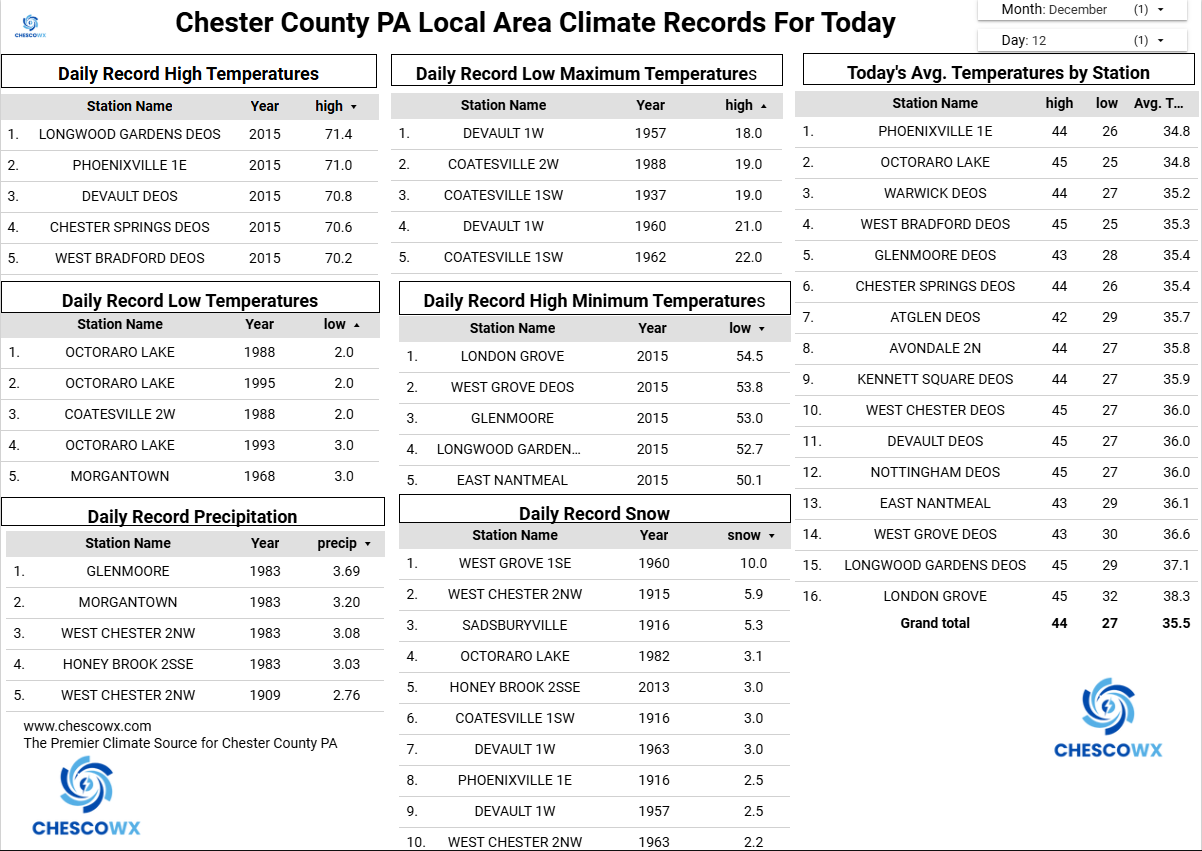
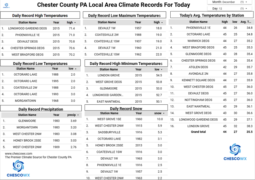
Today will be our 15th of the last 16 days with below normal temperatures as our Top 10 coldest starts to December in our history continues. It’s sunny today but clouds will increase tomorrow with snow arriving after 10pm. Snow will continue overnight till around 8am on Sunday morning before ending. The current NWS forecast has between 2" to 4" of snow across the area. We could see some blowing and drifting snow by afternoon across the typical open field and roads. We look to stay below freezing until Wednesday and then finally see a nice warmup with temperatures several degrees above normal through next weekend before we chill down to close to normal levels for the Christmas Holiday.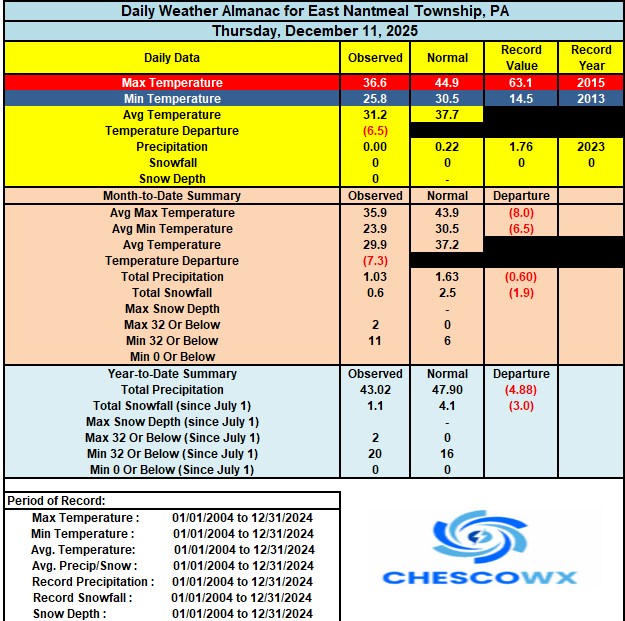
-
E PA/NJ/DE Winter 2025-26 Obs/Discussion
ChescoWx replied to LVblizzard's topic in Philadelphia Region
Today will be our 15th of the last 16 days with below normal temperatures as our Top 10 coldest starts to December in our history continues. It’s sunny today but clouds will increase tomorrow with snow arriving after 10pm. Snow will continue overnight till around 8am on Sunday morning before ending. The current NWS forecast has between 2" to 4" of snow across the area. We could see some blowing and drifting snow by afternoon across the typical open field and roads. We look to stay below freezing until Wednesday and then finally see a nice warmup with temperatures several degrees above normal through next weekend before we chill down to close to normal levels for the Christmas Holiday.
-

December 2025 regional war/obs/disco thread
RUNNAWAYICEBERG replied to Torch Tiger's topic in New England
Fight! -

December 14th - Snow showers or Plowable snow?
CoastalWx replied to Sey-Mour Snow's topic in New England
Reggie is a nice CJ for PYM county. -
What is the Cascades Alex!?
-
December 2025 regional war/obs/disco thread
Ginx snewx replied to Torch Tiger's topic in New England
I mean anyone who understands NE weather in winter knows that setup is conducive to CAD . With Eastern Canada in an icebox and NNE buried in snow odds favor a colder scenario by Christmas. Aspeta santus una Padre Santus. -
The -NAO look some are desperately banking on is also completely absent cold air in southeast Canada. It’s all in the west. And easterly flow is off >45F SST’s. It’s a complete losers bet to expect N to BN during that window. You’ll avoid a torch but still yield +5
-
The math does not hold man, I'm literally sitting here doing the testing and its an overfit. My best guess is found a value you think makes sense based on recent record and picked it because it fit observed data. All I've asked you, repeatedly I might add, is why 4" means something statistically and meteorologically. Why did you choose 4"? ENSO is not and never really has been a great predictor of snowfall here.
-

12/14: Sunday funday? Will the south win again?
RevWarReenactor replied to TSSN+'s topic in Mid Atlantic
It feels weird being in the bullseye for this storm. I am still expecting a rug pull. -
This warm up has been modeled for a atleast a week now and has universal support from all ensembles. Not sure why posting about what the models show long term would be weenieish lol
-

12/14: Sunday funday? Will the south win again?
MN Transplant replied to TSSN+'s topic in Mid Atlantic
I think we're semi-cooked on this one. It just frankly doesn't snow for very long on any of the models and it isn't like this is a juiced up event. We'll try again in January. -

Minor snow possible sunday 12/14/25
bluewave replied to WeatherGeek2025's topic in New York City Metro
LGA is in the same boat. We are talking about daily measurements and not storm totals spanning multiple days. No one said that they were. Just that we don’t get as much snow from them than we used to. -

Saturday night/Sunday 12/13-12/14 Jawn
anthonyweather replied to Ralph Wiggum's topic in Philadelphia Region
I have 4-5” of snowpack, should add another 1-3 Sunday, hoping we avoid rain at weeks end. Really feels like Christmas. Coldest December I can remember. The Lehigh river is half frozen .