All Activity
- Past hour
-

Occasional Thoughts on Climate Change
donsutherland1 replied to donsutherland1's topic in Climate Change
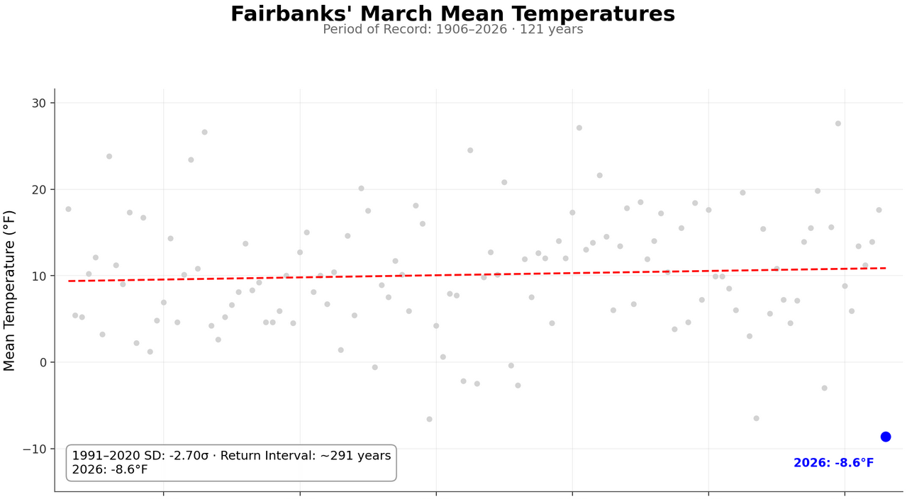
Using a chart inspired by Jeff Berardelli's return-time charts, here's how Fairbanks would look for March 2026: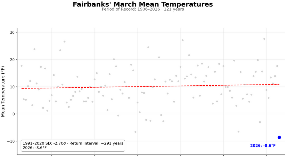
-
Banking on some crap weather but also that the near freezing temps are bogus. expecting upper 30’s to low 40’s. I’m good as long as then greening up of the landscape can proceed.
-
Break out the banana hammocks.
-
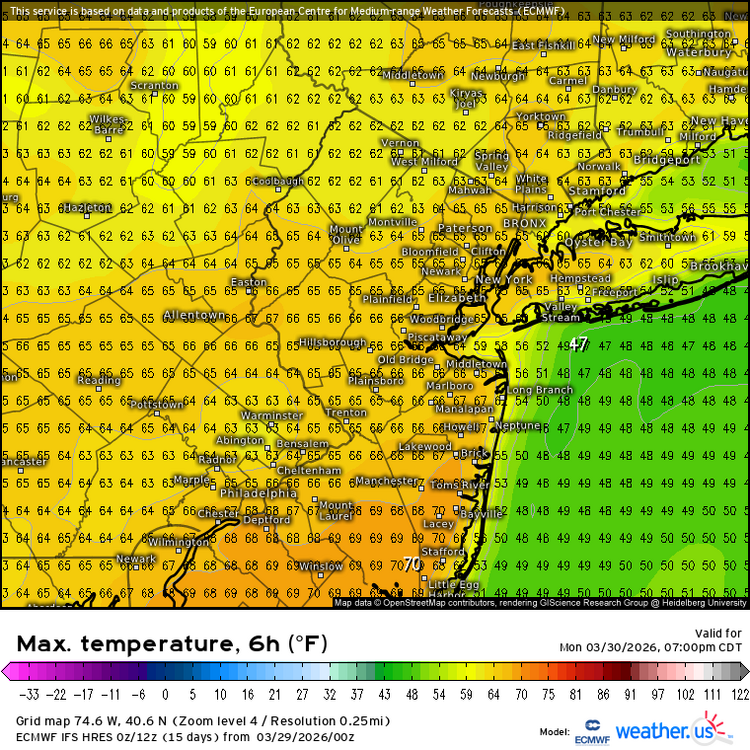
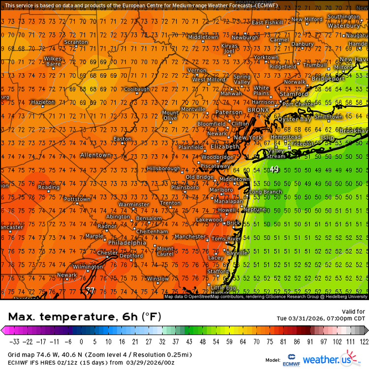
Brunt of the heaviest rain falls west but still a warm / cloudy and wettish week once to Wed - Easter Weekend.
-
Records: Highs: EWR: 89 (1945) NYC: 86 (1945) LGA: 86 (1945) JFK: 82 (1998) Lows; EWR: 23 (1959) NYC: 10 (1923) LGA: 25 (2022) JFK: 24 (2022) Historical: 1886 - Atlanta, GA, was drenched with a record 7.36 inches of rain in 24 hours. (The Weather Channel) 1920 - Clear Spring, MD, received 31 inches of snow in 24 hours to establish a state record. (Sandra and TI Richard Sanders - 1987) 1921 - The temperature in Washington D.C. dropped from 82 degrees to 26 degrees thus ending an early spring. (David Ludlum) 1935 - A severe duststorm blanketed Amarillo, TX, for 84 hours. During one six hour period the visibility was near zero. (28th-31st) (The Weather Channel) 1945 - Providence, RI, hit 90 degrees to establish a March record for the New England area. (The Weather Channel) 1987 - Thunderstorms spawned tornadoes in Mississippi, and produced high winds and heavy rain in Louisiana. Thunderstorm winds gusted to 92 mph at Houma LA, and caused a million dollars damage in Terrebonne Parish. Avondale LA was deluged with 4.52 inches of rain. (The National Weather Summary) (Storm Data) 1988 - Severe thunderstorms in the Lower Mississippi Valley spawned a tornado which injured two persons at Bunkie LA, and produced high winds which down a large tree onto a trailer at Bastrop LA claiming the life of one child and injuring another. (Storm Data) (The National Weather Summary) 1989 - Thunderstorms produced torrential rains in northeastern Texas and southwestern Arkansas. Longview TX reported 14.16 inches of rain. More than eleven inches of rain at Henderson TX caused a dam to give way, and people left stranded in trees had to be rescued by boat. Total damage in northeastern Texas was estimated at 10 to 16 million dollars. (The National Weather Summary) (Storm Data) 1990 - Thunderstorms developing ahead of a cold front produced severe weather in southeastern Texas and southern Louisiana. Thunderstorms spawned seven tornadoes, including one which injured seven persons at Gray LA. Thunderstorms also produced golf ball size hail and wind gusts to 70 mph at Port O'Conner TX, and produced up to six inches of rain in Beauregard Parish LA. (Storm Data) 2007 - Eighteen year old Corey Williams is killed by a lightning bolt in Carbondale, IL, at the Community High School's first home track meet of the season. 2011 - A record 766 inches of snowfall at Boreal Ski Resort and nearly 59 feet at Squaw Valley in California's Sierra Nevadas are just two areas where snowfall records have been broke.
-
Finishing +3 in March is climbing out of a deep winter hole with -5 in Jan and February
-

2025-2026 ENSO
Stormchaserchuck1 replied to 40/70 Benchmark's topic in Weather Forecasting and Discussion
^I've been surprised how cold Alaska has been this Winter relative to the 500mb pattern there. There hasn't been a lot of strong +EPO. -
Not Debbie’ing at all. This March has been a lamb overall. I’m just referring to what the CONUS anomalies will look like. We’re running around +3F but you don’t have to go far to find +8F in PIT. Of course it gets even warmer further west.
-
34 / 35 off a low of 23 (coldest for a while) Quick warmup upper 50s to low 6oOs in the warmest spots. Warm week ahead two days of sunshine Mon / Tue then warm and cloudy wet Wed - the East3r weekend. Onshore / backdoor TBD Thu / Sat. Perhaps drying out by the 7th but cooler - near normal overall beyond that till about mid month.
-
*looks at the front* i don't mind the rain, we need that... I don't need 40s in Aprii... From the morning LWX AFD. KEY MESSAGE 3...A frontal passage midway through next week will have potential to bring showers and thunderstorms to the region. Broad ridging is forecast to start breaking down early this week allowing an upper-level trough to progress eastward to the north of the region. Strong high pressure is likely to be anchored over the north-central Atlantic Ocean acting as a block to the east and southeast. A front associated with the trough is forecast to drop into the region from the north/northwest bringing the potential for showers and thunderstorms Wednesday into Thursday. Uncertainty remains high on shower/thunderstorm coverage along with overall rainfall amounts associated with the boundary. Depending on the position and strength of the high over the Atlantic Ocean, the front could become hung up over our region becoming a focus for the continued development of showers and thunderstorms. This solution would bring the most rain to the region, especially if the front stalls over the northern parts of our region. If the high is further offshore and weaker, the front will be able to progress further south leading to less precipitation totals and coverage as well as much cooler temperatures. The large model spread in frontal position is narrowing at least for Thursday, with increasing confidence the front will push to the south. However, it may try to lift back north at some point toward the end of the week. Temperature spread remains large (between 40 and 85 degrees for highs) by the end of the week. The threat for strong to severe thunderstorms with the frontal passage Wednesday may be tempered due to the lack stronger upper-level lift, but there may be enough instability and shear to allow for some stronger/organized thunderstorms.
-
I thought New Brnswck hit 70 on 3/16 but see it was 69. Other nearby are at 7 or 8 >70 days due to the 16th and the 20th as well.
-
Models are drying out for later this week. Shocker.
-
Debbie.
-
28 and heavy frost
-
It’s 28 here already. I don’t radiate well…
-
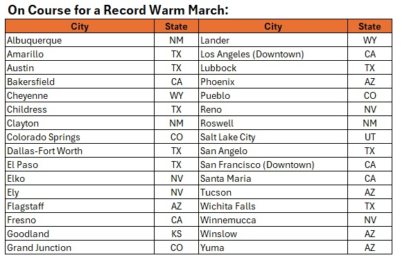
UHI, which is an important contributor, has been mentioned in several of the past Phoenix-related threads. Even setting aside, UHI, there has been a strong warming trend in Arizona and the Southwest. During 1970-2025, Arizona's minimum temperatures have warmed an average of 0.6°/decade. Phoenix's have increased by 0.8°/decade. In terms of maximum temperatures, Arizona's rate of warming has been 0.7°/decade while Phoenix's has been 0.8°/decade. The differences are a reasonable but not perfect proxy for the impact of UHI. The ongoing March heat is widespread. The following stations with 100-year or longer climate records are on course for their warmest March on record. Some will break their existing records by sizable margins.
-
The warm spots like New Brunswick have a chance at another 1-2 March days reaching 70° and could get close to 2012. Time Series Summary for New Brunswick Area, NJ (ThreadEx) - Month of Mar Number of 70° days Click column heading to sort ascending, click again to sort descending. 1 1945 11 0 2 2012 8 0 3 1946 7 0 4 2026 6 3 - 1921 6 0 5 2016 5 0 - 1989 5 0 - 1948 5 0 - 1913 5 1 - 1910 5 2 - 1903 5 0
-
Assy ahead
-
I don’t see the appeal in that. It’s not like we have some vegetation that looks like that. Sticks out like an ugly soar thumb.
- Today
-

2026-2027 El Nino
snowman19 replied to Stormchaserchuck1's topic in Weather Forecasting and Discussion
The big WWB has begun to show up on visible satellite -

2026-2027 El Nino
bluewave replied to Stormchaserchuck1's topic in Weather Forecasting and Discussion
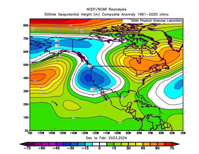
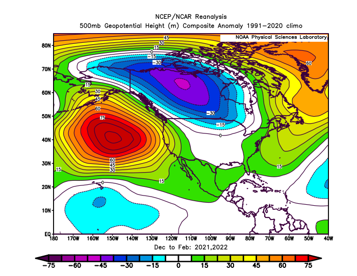
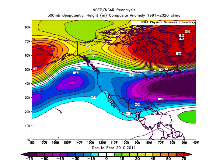
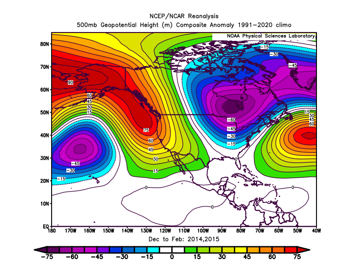
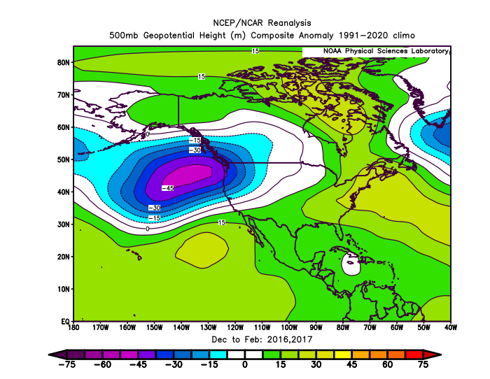
There also seems to be a type of underlying pattern with pairs of winters sharing similar overlapping locations of where their primary ridge and trough locations are found. We can take this back to at least the 09-10 to 10-11 winters. Same story for the 2020s so far. So in a very general sense perhaps the next few winters will find a way to share this similarity also. Obviously, this is all in hindsight and we will need to see how things evolve heading into next winter and beyond. It’s interesting that the models are indicating a potentially robust El Niño development in 26-27 following two winters with strong blocking across the North Pacific into Western North America like we saw following 13-14 and 14-15.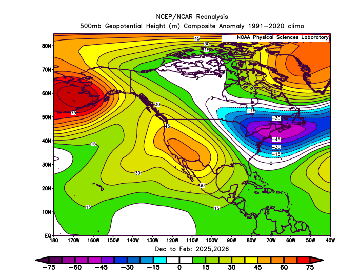
-

Central PA Spring 2026 Discussion/Obs Thread
pawatch replied to Voyager's topic in Upstate New York/Pennsylvania
25 degrees this morning. Slight frost -
Low of 26 with frost. It will probably be 8 months until we are this cold again.
-
It's happening
-
25 here. Looking forward to some warmer weather.