All Activity
- Past hour
-

Central PA Spring 2026 Discussion/Obs Thread
Mount Joy Snowman replied to Voyager's topic in Upstate New York/Pennsylvania
Low of 48 with .37” of rain. -

Central PA Spring 2026 Discussion/Obs Thread
Jns2183 replied to Voyager's topic in Upstate New York/Pennsylvania
I'm really sorry to hear this. That cold February followed by March warmth followed by April 8th freeze then hyper Summer before the 2.6-3std deviation freeze on 21st was the perfect trap. Sent from my SM-S731U using Tapatalk -
Looks meh there.
-

2026-2027 Strong El Nino
40/70 Benchmark replied to Stormchaserchuck1's topic in Weather Forecasting and Discussion
Agreed, there were some competing forces. I have also mentioned that last season still had a notable dearth of true coastals, February blizzard not withstanding. However, we were still able to produce above average snowfall because it was consistently so anomalously cold. I think it was a combination of factors....I agree CC is playing a hand, but it's also important not to get carried away with over attribution. There are other reasons last season was not a 1995 redux....most notably, the solar cycle was somewhat more hostile and there wasn't as much high latitude blocking. There was indeed a far amount last season given the high solar/strong -QBO combo, but 1995 featured one of the more impressive seasonal blocking displays on record given the ascending solar phase shortly after min. That being said, I do agree 1995 was a decent analog in some respects...it was one of my main ENSO analogs. -
Another nice weekend incoming here.
-
This was the 8th warmest March 1st to April 29th for NYC at 50.8°. Time Series Summary for NY CITY CENTRAL PARK, NY Warmest March 1 April 29 Click column heading to sort ascending, click again to sort descending. 1 1945-04-29 53.2 0 2 2012-04-29 52.8 0 3 2010-04-29 52.7 0 4 1921-04-29 52.1 0 5 2024-04-29 51.7 0 6 2016-04-29 51.0 0 7 2023-04-29 50.9 0 8 2026-04-29 50.8 0 9 2025-04-29 50.7 0 10 1985-04-29 50.2 0 11 1946-04-29 50.1 0 12 2021-04-29 50.0 0 - 2002-04-29 50.0 0 - 1977-04-29 50.0 0 13 1991-04-29 49.9 0 - 1903-04-29 49.9 0 14 1973-04-29 49.7 0 15 1979-04-29 49.5 0 16 1998-04-29 49.4 0 - 1986-04-29 49.4 0 - 1976-04-29 49.4 0 17 1910-04-29 49.2 0 18 2020-04-29 49.1 0 - 2006-04-29 49.1 0 - 1990-04-29 49.1 0 - 1987-04-29 49.1 0 19 1968-04-29 49.0 0 20 2000-04-29 48.9 0 - 1981-04-29 48.9 0 21 2022-04-29 48.8 0 22 2008-04-29 48.7 0 - 1938-04-29 48.7 0 - 1878-04-29 48.7 0 23 1963-04-29 48.5 0 24 2019-04-29 48.4 0 - 1913-04-29 48.4 0 25 2009-04-29 48.3 0 - 1995-04-29 48.3 0
-
0.05", 2.22" for month, a number of stream gauges with extremely low conditions https://waterdata.usgs.gov/state/maryland/
-
Getting to the point where we can pull BN days and we’ll still say it was a nice day. Like 65/35 with full sun.
-
Some stations in NNE really aren’t AN. It’s also typically a cool place in April. AN there still is cooler than SNE. Meh.
-
Temps in April above March levels? Wine?
-
2026-2027 Strong El Nino
40/70 Benchmark replied to Stormchaserchuck1's topic in Weather Forecasting and Discussion
Fair enough, but all else being equal, I would still bet on +PDO developing during a stronger El Nino....especially given the past few events have been accompanied by -PDO. -
complete dog shit take you had. That’s not a pattern change; it’s a blip in the persistence. Signal vs noise. Can’t wait for the April re-analysis for NNE. + AN at or above March levels. As MOST of us thought.
-

2026-2027 Strong El Nino
bluewave replied to Stormchaserchuck1's topic in Weather Forecasting and Discussion
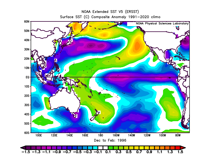
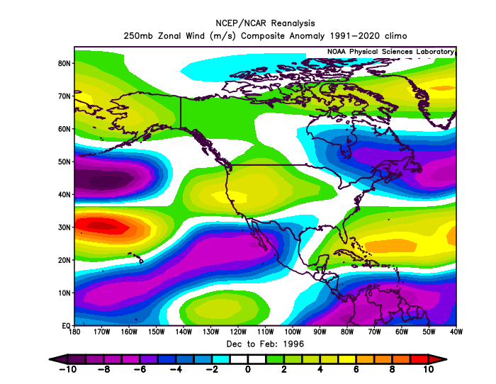
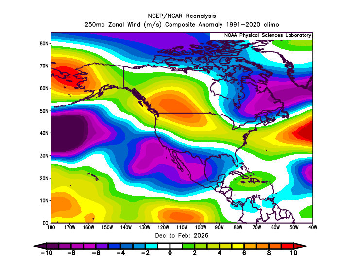
This past winter was really interesting in that we got the warm pool east of Japan interacting with the warm pool off of California and the Baja. So it prevented us from getting a strong +PDO like we had in 1995-1996 with that weak La Niña. So while this was the best winter of the 2020s so far from NYC to Boston, the overpowering Northern Stream was only able to relax from late January to late February. This prevented the wall to wall historic snowy outcome from November 1995 to April 1996. Notice how much stronger the Northern Stream was this past winter compared to 1995-1996. My guess is that the warm pool east of Japan in concert with the much warmer climate may have increased the Northern Stream just enough to take the 1995-1996 historic snows off the table. But we still were able to get the outstanding February KU before the Northern Stream returned for March.
-
-
-
0.50” here
-
Let's brown up some lawns.
-
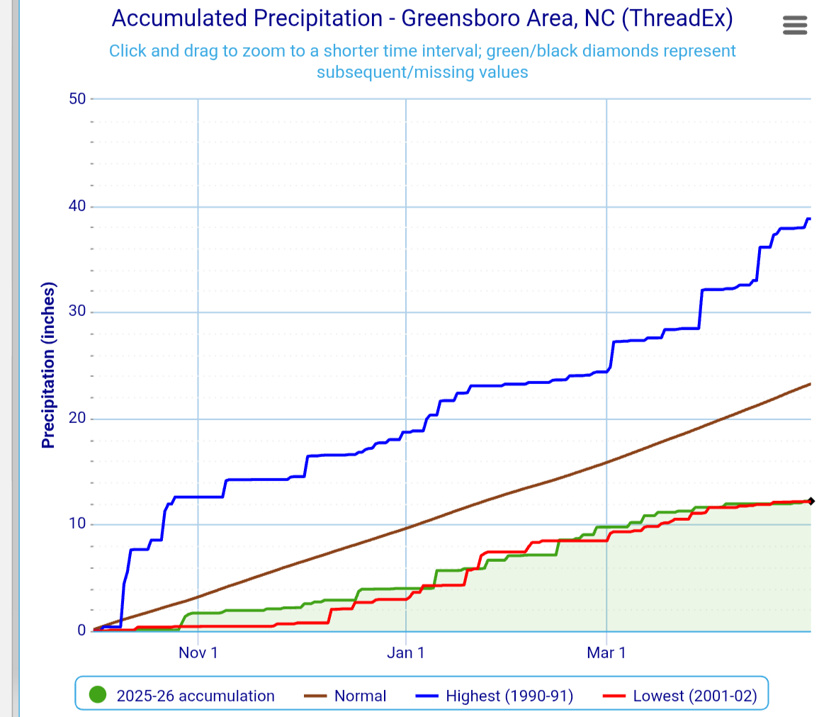
Still running near record low precip since October
-
.4” last night. Currently 46 and raw. .
-
2026-2027 Strong El Nino
40/70 Benchmark replied to Stormchaserchuck1's topic in Weather Forecasting and Discussion
Kind of analogous to ENSO in that the PDO cycle itself is still operating as it always has, however, the baseline warming is limiting it's ability to drive the weather pattern around the hemisphere. Interesting. -

Richmond Metro/Hampton Roads Area Discussion
Deep Creek replied to RIC Airport's topic in Mid Atlantic
Unless we get a freak monsoon today, gonna finish with 0.97” of rain IMBY for the month. To go along with 1.95” in March. Yeesh -
Steindrite
-

Central PA Spring 2026 Discussion/Obs Thread
mahantango#1 replied to Voyager's topic in Upstate New York/Pennsylvania
.53 rain for the event. - Today
-

2026-2027 Strong El Nino
GaWx replied to Stormchaserchuck1's topic in Weather Forecasting and Discussion
Snapshot current RONI equivalent appears to me to be fairly steady near +0.3C (temporary pause). -
2026-2027 Strong El Nino
bluewave replied to Stormchaserchuck1's topic in Weather Forecasting and Discussion
Yeah, I get the joking. It’s good to keep things light in here. We switched out of the traditional -PDO +PDO relationship following the big warming east of Japan after the 2015-2016 El Niño.This really increased following 2018-2019. So the current models are forecasting more of basin-wide warming where we get a zone of warm SSTs from Japan to the Baja. We saw that this past winter going into the spring with the record +PMM and remaining warm pool east of Japan. We will probably have to revisit this paper again after this event and see where things stand. https://www.nature.com/articles/s41558-025-02482-z Pan-basin warming now overshadows robust Pacific Decadal Oscillation The Pacific Decadal Oscillation (PDO) has served as a key index linking basin-scale climate variability to marine ecosystem changes in the North Pacific. However, recent apparent breakdowns of PDO–ecosystem correlations have raised concerns about the stability of the mode and its continued relevance in a warming climate. Here we show that basin-wide warming now overwhelms PDO-related sea surface temperature (SST) variability, although neither the PDO’s spatial pattern nor its strength have changed. We introduce the pan-basin pattern as a complementary index to describe the non-stationary SST baseline of the North Pacific. Regional SSTs increasingly reflect the superposition of these two signals, providing an explanation for weakened or inverted PDO–ecosystem correlations. Future use of the PDO index in management will require discerning the effects of internal dynamics from those of absolute changes in SST as extreme and no-analogue ocean conditions driven by interacting natural variability and anthropogenic warming become more common. We demonstrate that the leading mode of interdecadal North Pacific SST changes recently transitioned from the PDO to a pattern of unidirectional change across the entire basin (that is, the PBP). For the first prolonged period of the recent observational record, a negative ‘cold’ PDO phase failed to coincide with cool SST anomalies in the eastern Pacific—a harbinger of the increasing non-stationarity in relationships between the PDO and regional SSTs (Fig. 3d,e). Despite explaining proportionally less variance, ongoing robust PDO variability indicates that drivers of the mode’s SST anomaly footprint have been resilient to warming through the early twenty-first century (Figs. 1 and 2). As the PDO is a statistically emergent pattern integrating several processes (for example, stochastic Aleutian Low forcing, teleconnections with the tropics, and ocean Rossby waves)4,47, its future evolution will depend on how these contributing processes are cumulatively impacted by warming across timescales. Although the historical physical drivers of North Pacific decadal variability are relatively well understood4,48, the biophysical mechanisms through which ecosystems respond are less so. The PDO has historically served as a reliable proxy for SST in much of the North Pacific. However, as regional SST anomalies continue to diverge from those historically expected based on PDO signals (Fig. 3d–g), there will be a growing need to distinguish impacts associated solely with SST anomalies from those produced by the dynamics related to the PDO (for example, changes in upwelling, transport or source waters). For example, since the 2021 transition into the negative PDO phase (Figs. 3d,e and 4b,c), warming is superimposed on a cold PDO regime in the eastern North Pacific, leading to confusion in the community regarding the expected biological effects26. Further investigation into the mechanisms behind PDO–ecosystem relationships should prioritize discernment of temperature-specific effects on biology from the effects of other physical or biogeochemical processes. Given the ongoing stability of the PDO pattern, the PDO index probably remains a useful indicator of North Pacific climate variability, but perhaps with its ecological relevance in how it reflects changing dynamical processes rather than regional SST anomalies. As the PBP–temperature baseline climbs in concert with global ocean warming, local and regional SST anomalies that would historically have been associated with an exceptionally strong PDO and/or El Niño (for example, >2 standard deviations) will occur more frequently. For example, constructive signals between internal variability and secular warming from 2014–2020 contributed to warm temperature extremes during this period (for example, ref. 49). Quantification of the range of internal variability related to the PDO and other modes will be needed to constrain the potential for climate extremes resulting from interaction of internal variability and anthropogenic warming, leveraging approaches such as palaeoclimate records, long model simulations or large model ensembles50,51. Constraining internal variability and stability is also necessary for understanding the future of PDO impacts beyond the North Pacific (for example, theorized impacts on hydroclimate in western North America and northeastern Asia)52,53,54,55,56,57 and its role in modulating global climate. Global-scale trends and internal variability are now both important determinants of North Pacific climate48,58, with the influence of pan-basin warming surpassing that of the PDO within the past decade. The combination of long-term warming and natural variability has already begun to produce profound physical and ecological changes throughout the North Pacific, including severe marine heatwaves with ecosystem-wide impacts59,60, rapid sea ice declines and novel weather patterns in the Alaskan Arctic61, and new human–wildlife conflicts62. Management decisions based on historical baselines will fail to capture increasingly important emergent interactions between anthropogenic warming and internal variability. This increased uncertainty in associations between basin-scale variability and regional responses underscores the need for management approaches to incorporate dynamical modelling and prediction of North Pacific climate (for example, ref. 63), rather than relying on historical relationships with basin-scale indicators as predictors. Given that the internal variability of the North Pacific is especially strong, a similar emergence of pan-basin warming over internal variability is probably already occurring in other basins, suggesting that the recontextualization of indices of climate variability under warming is needed widely.