All Activity
- Past hour
-
Monthly rain: EWR: 10.16 NYC: 8.49 LGA: 7.84 JFK: 7.46 PHL: 7.43 TTN: 7.34
-

Augdewst 2026: Summer's Last Stand
Brian5671 replied to Prismshine Productions's topic in New England
Just post it saying SW CT bullseye and you'll be right. -

Augdewst 2026: Summer's Last Stand
tamarack replied to Prismshine Productions's topic in New England
Of course, though we got all of 0.03" last evening, along with a near miss TS that terrorized our dog. We've had 5 rain events in the past 2 weeks for a grand total of 0.18". drip, drip, drip -
Rainfall 8/27 EWR: 2.32 PHL: 2.32 TTN: 1.16 NYC: 0.45 ISP: 0.22 LGA: 0.18 JFK: 0.1
-

Augdewst 2026: Summer's Last Stand
WxWatcher007 replied to Prismshine Productions's topic in New England
It’s been fall up here for the last week and a half. It’s coming. 9.78” at WXW1 since July 1. Just incredible rainfall in southern CT, but it’s been your year. Big snows, big storms, big rains… -
Go get them Wiz!!!
-

2026-2027 Record-breaking El Nino
40/70 Benchmark replied to Stormchaserchuck1's topic in Weather Forecasting and Discussion
Where is that? Nationally last year wasn't close to 1995-1996. Here is the PNA from last winter DJFM: 2026 -1.41 0.79 -0.56 -1.74 That is very favorable?? It was the orientation of the PV that saved us, not the PNA. Very predictable outcome considering the high solar/extreme easterly QBO predisposition towards intense mid winter +TNH regimes. In fact, strong +TNH is often accompanied by RNA. It did coincide with an interval of PNA from mid January into February in this case, which probably heightened it, but the PNA was not last winter's defining teleconnection. Strong +TNH season. -
Records: Highs: EWR: 102 (1948) NYC: 100 (1948) LGA: 99 (1948) JFK: 98 (1973) Lows: EWR: 51 (1941) NYC: 50 (1885) LGA: 54 (1986) JFK: 53 (1986) Historical: 1816: Frosts continue in New England i 1898 - Torrents of rain accompanied by a furious wind upset the rain gage at Fort Mohave AZ. However, water in a wash tub set out on the mesa, clear of everything, measured eight inches after the 45 minute storm. (The Weather Channel) 1911 - Saint George, GA, was deluged with 18.00 inches of rain in 24 hours to establish a state record. (The Weather Channel) 1954: Thunderstorm winds and hail struck Alachua and Orange Counties in Florida. A tornado touched down briefly in Orlando and ripped up three large oaks. Considerable wind damage to roofs and several automobiles were hit by falling trees. A child was killed by lightning at Lake City, FL. Several others were injured. (Ref. Wilson Wx. History) 1959 - Lieutenant Colonel William Rankin bailed out of his plane at a height of 46,000 feet into a violent thunderstorm, and lived to write about the 45 minute journey (which normally would have been a thirteen minute descent). He described it as one of the most bizarre and painful experiences imaginable. (The Weather Channel) 1964: NASA launched the first NIMBUS weather satellite. More advanced than the pioneering TIROS satellites, the NIMBUS program featured new cameras and sensors that continued well into the 1970s. (Ref. Wilson Wx. History) 1968: One man was seriously injured by lightning while riding on a roller coaster at a Denver, CO amusement park. An airline employee was injured when lightning struck a jetliner he was servicing at Stapleton International Airport. A lightning caused fire did extensive damage to a house and to several others. (Ref. Wilson Wx. History) 1971 - Heavy rains from Tropical Storm Doria caused devastating floods in central and northeast New Jersey resulting in 138 million dollars damage. In southeastern Pennsylvania, high winds downed trees and power lines, and in New York City, heavy rains flooded streets and subways. (David Ludlum) 1973 - An F4 tornado touched down near Canaan, New York, and moved to western Massachusetts. Three people were killed in West Stockbridge, Massachusetts when a truck stop was destroyed, and another person died in a ruined house nearby. 1974: Central New Jersey--Lightning resulted in one death. Sanford, NC -- A woman in her backyard was hit by lightning and died in a hospital. (Ref. Lightning-The Underrated Killer.pdf) 1977: Severe flooding hit parts of southwest Oklahoma after 8 to 10 inches of rain fell over the area. The hardest hit areas were between the West Cache and Blue Beaver Creeks, near the communities of Cache, Faxon, and Medicine Park, all in Comanche County. Six children had to be rescued by helicopter from a knoll between the two creeks, while several other families had to be evacuated. Damage was quite severe as many houses reportedly had two to four feet of water flowing through them. The floods also washed away several bridges. (Ref. Wilson Wx. History) 1978: Hail up to six inches deep was recorded during a severe thunderstorm at Colorado Springs, CO. (Ref. AccWeather Weather History) 1980: Two inches of snow fell at Sherman Pass, WA. (Ref. AccWeather Weather History) 1982: A strong cold front pushed through bringing record low temperatures across parts of the Great Lakes and Ohio Valley. Record lows included: International Falls, MN: 30°, Duluth, MN: 34°, Marquette, MI: 36°, Lansing, MI: 36°, Ste. St. Marie, MI: 37°-Tied.(Ref. Additional Temperatures Listed On This Link) 1985: In the early morning hours eight inches of rain pounded Le Mars, IA. Every home in town had some problems and houses that had never had water in their basements suddenly had 6 inches of water standing on their floors. Later that afternoon, more severe weather developed in northwest Iowa pounding several counties with golfball size hail and high winds in excess of 60 mph. Window and tree damage was extensive across Emmett, O'Brien, Cherokee, Clay, Buena Vista and Plymouth Counties. (Ref. Wilson Wx. History) 1986 - The temperature at Apalachicola, FL, dipped to 62 degrees to shatter their previous August record by four degrees, having tied their August record high of 99 degrees on the 2nd of the month. (The Weather Channel) 1987 - Severe thunderstorms broke the heat in the southeastern U.S. and the Gulf Coast Region, but not before seven cities reported record high temperatures for the date. The severe thunderstorms produced wind gusts to 80 mph downing large trees around Horse Shoe NC, and pelted southeastern Meridian MS with hail two inches in diameter. (The National Weather Summary) (Storm Data) 1988 - Tropical Storm Chris spawned a tornado near Manning, SC, which killed one person, and spawned three tornadoes in North Carolina. Chris produced one to two foot tides, and three to six inch rains, over coastal South Carolina. Severe thunderstorms in New York State and Vermont, developing ahead of a cold front, spawned a tornado which killed one person at Hector NY, produced tennis ball size hail at Brandon VT, and produced wind gusts to 80 mph at Lyndonville VT. (The National Weather Summary) (Storm Data) 1989 - Early morning thunderstorms in Nebraska produced 4.50 inches of rain around McCook, and 4.65 inches near Auburn and Brownville. Showers in Montana pushed the rainfall total for the month at Havre past the previous August record of 3.90 inches. (The National Weather Summary) 1990 - Between 3:15 p.m. and 3:45 p.m. a devastating F5 tornado ripped a 16.4 mile-long path through portions of Kendall and Will counties in northern Illinois. A total of 29 people were killed, and 350 more were injured. An estimated $160 million in damages occurred. The tornado's path width ranged from 200 yards to half a mile. A total of 470 homes were destroyed, and another 1000 homes were damaged. Sixty-five thousand customers lost power. 1992: The coolest August temperature ever recorded in Wichita Falls, TX when the temperature fell to a cool 53°. Rapidly intensifying Typhoon Omar cut right across the U.S. territory of Guam in the western Pacific. At the time of landfall winds were sustained at 125 mph around the eye. Anderson Air Force Base had sustained winds of 104 mph with a peak gust to 150 mph, recorded a pressure reading of 945.8 millibars or 27.93 inches of mercury, and was deluged with 16.41 inches of rain. Agana Naval Air Station reported wind gusts exceeding 170 mph and a low pressure reading of 932 millibars or 27.52 inches of mercury. One person was killed, 132 people were injured, over 4,000 homes were damaged or destroyed, and total damage was $487 million dollars. This was the strongest typhoon to strike Guam since Typhoon Pamela in 1976. (Ref. Wilson Wx. History) 2001: Snow plows in the summer! Hail mostly three quarter inches in diameter but a few stones as large as 1 1/4 inches in diameter fell on the west side of Silver City, New Mexico for 40 minutes and accumulated to a depth of 6 inches. Many vehicles were stranded until snow plows could clear hail from the roadways. (Weather Guide Calendar with Phenomenal Weather Events 2007 Accord Publishing, USA) 2002: A very far to the north occurrence for this phenomenon. A funnel cloud was seen and photographed from near Wonder Lake in, AK’s Denali National Park. The funnel appeared several miles north of the lake; the bottom of the visible funnel almost touched the ground. (Weather Guide Calendar with Phenomenal Weather Events 2011 Accord Pub. 2010, USA) 2003: Two men were struck and injured by a nearby lightning strike at the Albemarle County, VA Fair in the North Garden area of the county. (Ref. Lightning - Virginia Weather History) 2005 - Hurricane Katrina attained Category 5 status on the morning of August 28 and reached its peak strength at 1800 UTC that day, with maximum sustained winds of 175 mph and a minimum central pressure of 902 mbars (26.6 inHg).
-
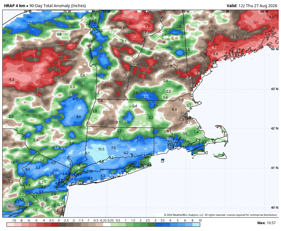
Picked up .50" rainfall from event that just wrapped up. So glad we avoided anything heavy in my immediate area. Soils are wet and with the declining sun angle they are taking longer to dry out. August rainfall: 8.34". Rainfall Y.T.D.: 41.15". We'll see if wet pattern holds into and through the Fall. Might be headed for a 50" rainfall year. At this point I'm willing to bet on the over.
-
Socked in with low clouds and you look at satellite and realize it's clear like 10 miles west of me lol
-
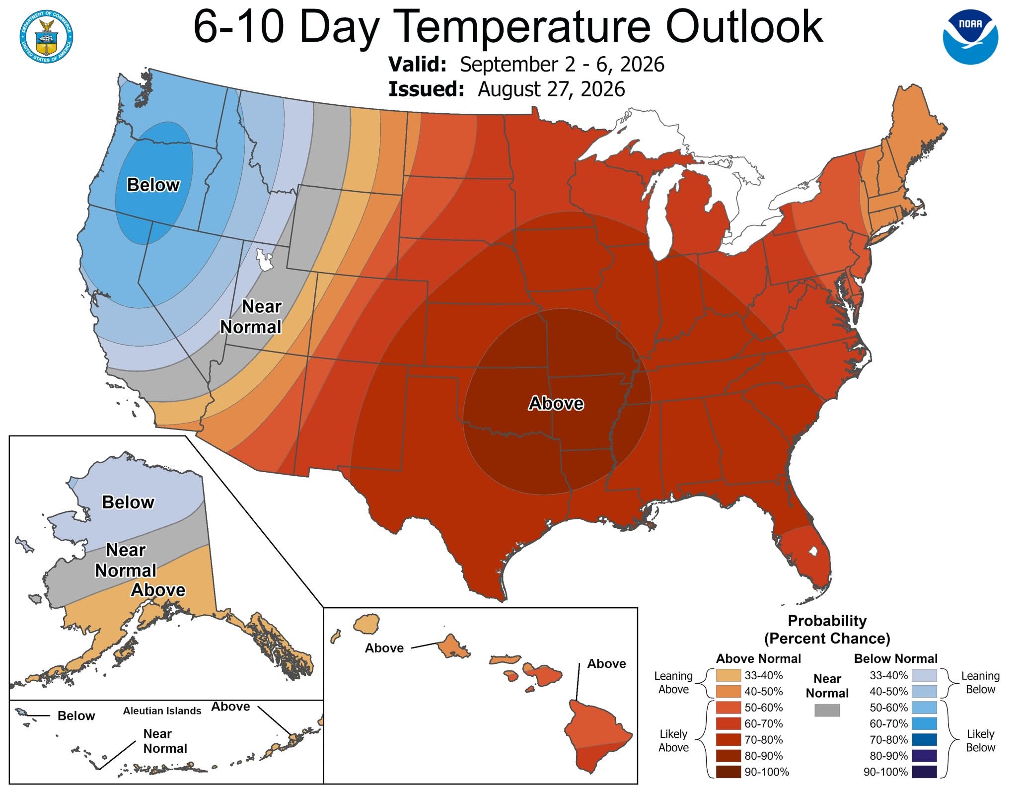
78 / 68 partly - mostly cloudy humid. Front clears through later today and we'll see if showers/storms are isolated. Great weekend and extended through Monday clear / mostly clear low - mid 80s and dry. The ridge comes in but clouds / showers may keep temps down Tue - Thu, otherwise overall warm to much warmer than normal 8/30 - 9/7 and beyond.
-

Augdewst 2026: Summer's Last Stand
weatherwiz replied to Prismshine Productions's topic in New England
Might start a thread for Monday - Wednesday (with a focus on Wednesday) just because I feel like it and people can post their feels about how they won't get anything -

2026-2027 Record-breaking El Nino
LakePaste25 replied to Stormchaserchuck1's topic in Weather Forecasting and Discussion
It was only 0.3 degrees warmer than 95-96 and 10-11. But the fact that 10-11 had much more -PNA shows that we need a more ideal pacific to produce the same cold.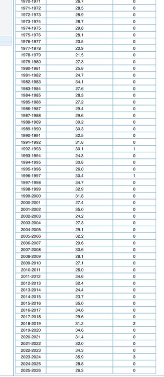
-
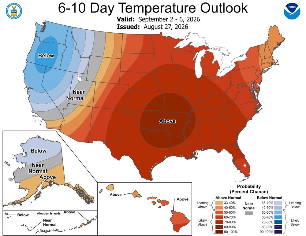
First week looks above average
-
0.25 last night.. 1.60 monthly total... 5.19 since May - 3 month total...
-

Augdewst 2026: Summer's Last Stand
Sey-Mour Snow replied to Prismshine Productions's topic in New England
Pretty rainy summer for southern half of Southern New England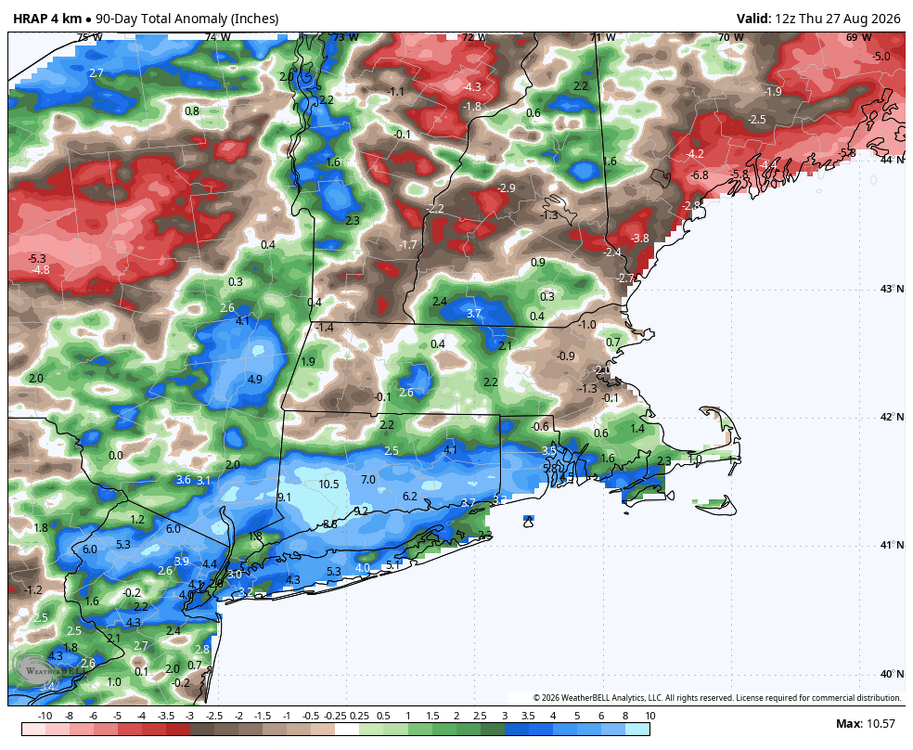
-
2026-2027 Record-breaking El Nino
40/70 Benchmark replied to Stormchaserchuck1's topic in Weather Forecasting and Discussion
Yea, I Iike that analog better from a +TNH (High solar/E QBO) perspective....2015 would have been my top polar analog had it been cool ENSO, but wish I had still used it. I'm not going to be as ENSO restrictive with weaker events moving forward, especially as ENSO continues to wash out some. The extra Pacific was much more hostile in general than 2015, which is somewhat related to ENSO, but def. a great polar analog. -
(002).thumb.png.6e3d9d46bca5fe41aab7a74871dd8af8.png)
Central PA Summer 2026 Discussion/Obs Thread
ChescoWx replied to Voyager's topic in Upstate New York/Pennsylvania
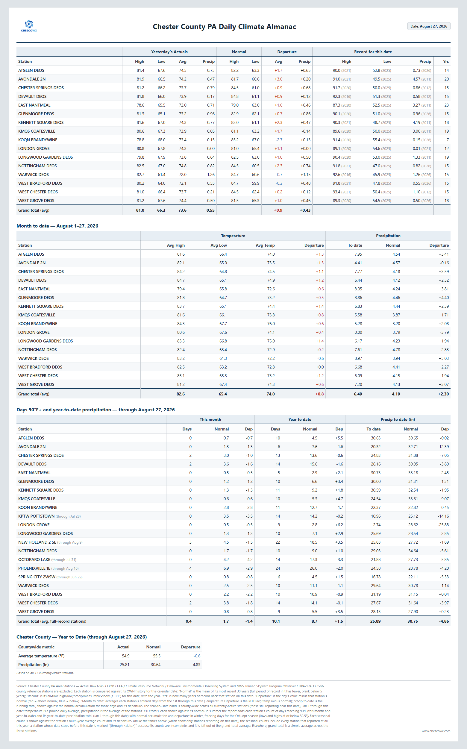
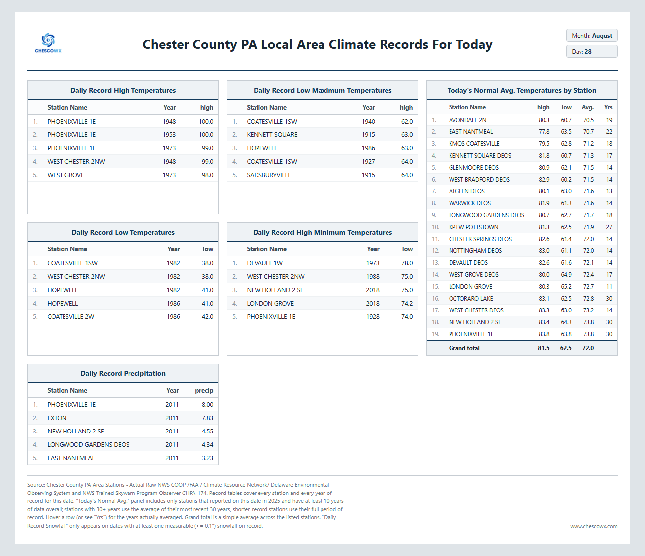
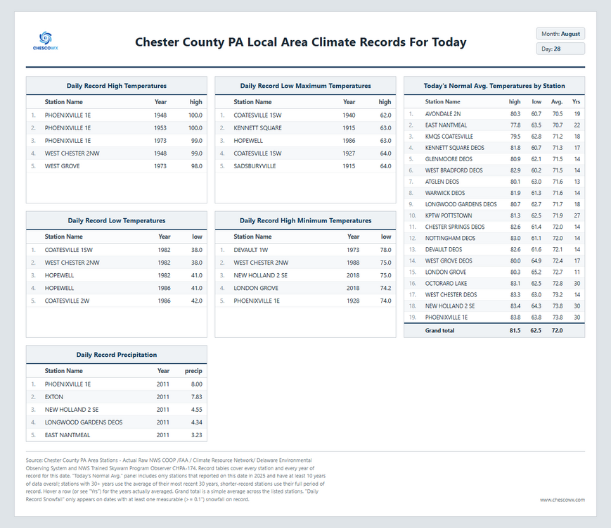
A nice weekend ahead with increasing sun today and continued below normal temperatures through the weekend. We warm to above normal highs in the mid to upper 80's by Monday lasting through Wednesday we then fall back to a bit closer to normal by the end of next week. Next rain chances look to be toward Tuesday.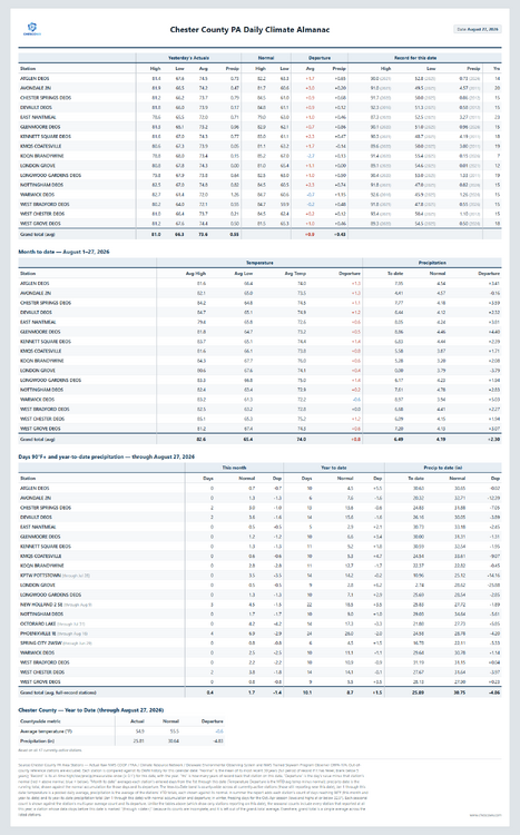
-
E PA/NJ/DE Summer 2026 Obs/Discussion
ChescoWx replied to PhiEaglesfan712's topic in Philadelphia Region
A nice weekend ahead with increasing sun today and continued below normal temperatures through the weekend. We warm to above normal highs in the mid to upper 80's by Monday lasting through Wednesday we then fall back to a bit closer to normal by the end of next week. Next rain chances look to be toward Tuesday.
-

2026-2027 Record-breaking El Nino
PhiEaglesfan712 replied to Stormchaserchuck1's topic in Weather Forecasting and Discussion
At the end of the day, the winter of 2025-26 was a warmer version of 2014-15. The 10+ departures in the West were much more widespread, and the cold in the East wasn't as strong or as long. -
Lol. Defending a political decision by accusing someone of being political.
-
2026-2027 Record-breaking El Nino
40/70 Benchmark replied to Stormchaserchuck1's topic in Weather Forecasting and Discussion
You understand both can be true, right? It's not as cold as the 1970s...got it.....but last season was not as conducive to sustained cold and high latitude blocking as 1995. -
2026-2027 Record-breaking El Nino
LakePaste25 replied to Stormchaserchuck1's topic in Weather Forecasting and Discussion
Yeah other than that stretch in late January, the last 2 winters featured just normal winter cold that we used to get much more frequently. -

2026-2027 Record-breaking El Nino
bluewave replied to Stormchaserchuck1's topic in Weather Forecasting and Discussion
The cold in the East this past winter was weak sauce compared the the hard winters of the 1970s.







.gif.812ed10957f5ec2fdbf02322613f527b.gif)