All Activity
- Past hour
-

2026-2027 Fall/Winter Mountain Thread
ncjoaquin replied to BlueRidgeFolklore's topic in Southeastern States
I have noticed, too, that GSP never uses the Hazardous Weather outlook. If this doesn't warrant a watch, you would think that they would at least issue a Hazardous Weather outlook. Other forecast offices have. -
It might be earlier than that. Keeps bumping up landfall time each run. We’re not working with a ton of time for this to fall apart and it doesn’t matter when the center crosses because that eyewall is obviously out ahead of it. Dangerous situation saw they increased max surge from 7 to 9 feet, not insignificant at all especially with the population center this is plowing into
-
Managed to get my (now major) hurricane sunrise this morning! Some low clouds blocked it a bit, but still well worth the early morning.

-
First light
-
Google DM brings this in around 7 to 8PM. Majority of the models have the pressure bottoming out around 1PM. That give us about a 6 hour window to weaken before landfall. Not much time there to work with at all. Better hope it doesn't strengthen much more this Morning.
-

2026-2027 Fall/Winter Mountain Thread
Tyler Penland replied to BlueRidgeFolklore's topic in Southeastern States
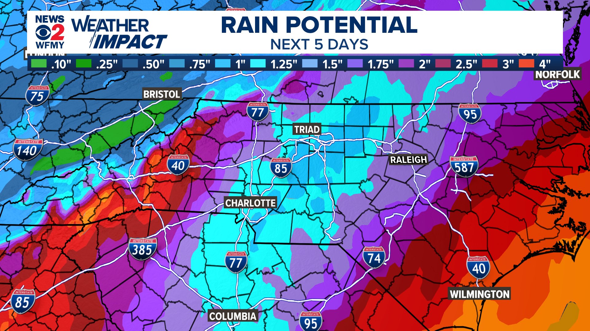
BTW, has anybody checked on GSP? They have yet to issue a single watch or advisory for this. Getting on my nerves having counties in my area of Georgia under a Flood/High Wind Watch right next door under FFC but nothing at all from GSP. -
I feel like that guy who does those Dos Equis commercials. ISSY once took on 60kt. shear and became a CAT3. When your wrong, your wrong and admit it. Surprised but not shocked. "Stay thirsty my friends." LOL
-
Recon is heading in for another pass.
-
65 to 80 mph gusts as far inland as la grange GA???? That definitely seems overdone.
-
Models accurately forecasted the 10-15 mb drop as it traversed the loop current eddy overnight.
-
-
Are there so few names that it is necessary to re-use Isaias when it was just used in 2020? Especially when it was a noteworthy storm which made landfall. Seems dumb. Anytime anyone talks about Isaias in the future it'll always be followed by "wait, the one in 2020 or the one in 2026?"
-
2026-2027 Fall/Winter Mountain Thread
Tyler Penland replied to BlueRidgeFolklore's topic in Southeastern States
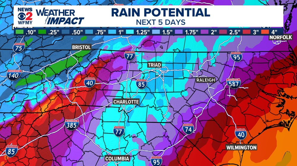
Also seeing it run east of the forecast track a bit. Destin landfall seems likely at this point. HRRR drops the hammer with rain on the escarpment tomorrow night. -
Yes, I though this window was going to close about 12 hrs early than it is. Nice from a met standpoint, not so nice for the Gulf coast.
-
Isaias is now a major. Bathtub doing bathtub things.
-
GFS says no….10/25 it has a monster trough and storm on the coast. Yup…it’s a junk model now, and way out in time, but it’s no different than saying what you’re saying. And why would we not want mild and comfortable in mid October? It’s exactly what we are supposed to have. Most of us have already had our first frost, and frozen vehicle morning just two days ago. We are stepping down nicely.
-
F'N... ALEET.
-
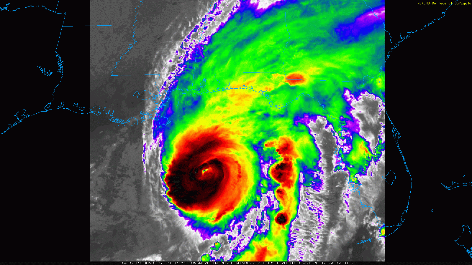
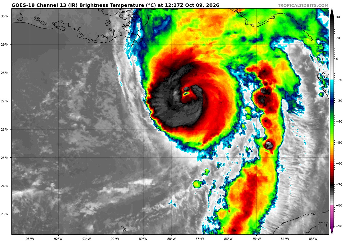
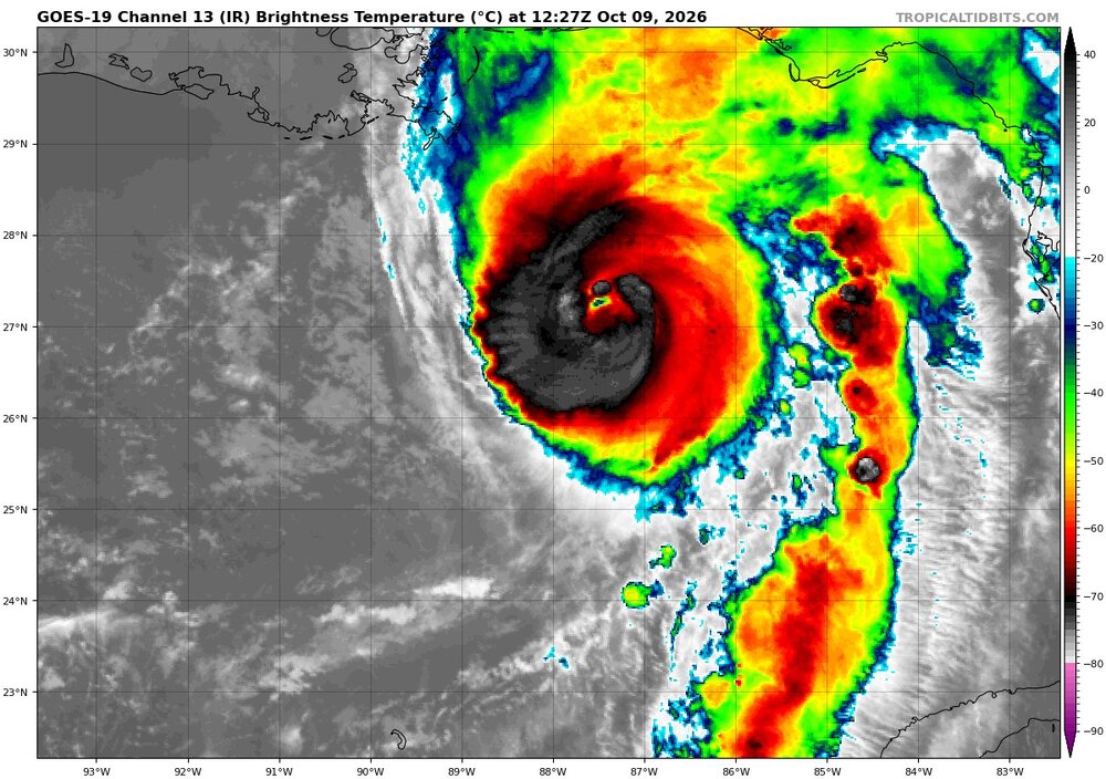
I cannot believe what I am seeing. Thing should be getting shredded like it hit the Hispaniola mountains yet the west side of the storm is enveloped with -60 tops.
-
Sorry, here was the D3 text and categorical risk. Doesn't say tor risk but I think we know... ...Delmarva into the Carolinas... Considerable strengthening of the deep-layer wind field is forecast on Sunday in advance of the midlevel trough. However, considerable cloud cover and areas of precipitation appear likely to limit air mass destabilization within the poleward-expanding warm sector. Nonetheless, boundary-layer dewpoints in the upper 60s to mid 70s will support pockets of modest instability, especially in areas where cloud breaks may occur. And given the presence of relatively strong low-level and deep-layer shear, a conditional risk for severe storms capable of damaging winds and perhaps a few tornadoes will exist Sunday into Sunday evening. Higher severe weather probabilities may be required in later forecasts if subsequent model data indicate greater instability than that currently depicted.
-

2026-2027 Fall/Winter Mountain Thread
GoAPPS replied to BlueRidgeFolklore's topic in Southeastern States
Isaias is now a major hurricane. 7:20 AM CDT Fri Oct 09 Location: 27.0°N 87.6°W Moving: NNE at 15 mph Min pressure: 959 mb Max sustained: 120 mph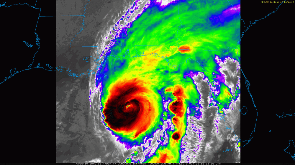
-
Latest pressure went up so slightly from 958 to 959. Maybe a sign that it has maxed out and some weakening could start happening during the day.
-
Another convective tower trying to wrap around the eye as it fights some intense shear on the West side. Wish we had one more pass to see if pressure drops or holds steady
-

2026-2027 Fall/Winter Mountain Thread
Maggie Valley Steve replied to BlueRidgeFolklore's topic in Southeastern States
Isaias is now a Major Hurricane with sustained winds of 120 in and near the eyewall. Tropical Storm Force wind extend out just about 200 miles from the center. -
Peak Season Forecast (Aug 20-Oct 20) Named Storms: 5 (6) Hurricanes: 3 (1) Major Hurricanes: 1 (1) Dolly, Edouard, Fay, Gonzalo, Hanna, Isaias (MH) Homebrew delivers again...
-
https://pbs.twimg.com/media/HUMGXpaXQAAwuKb?format=jpg&name=medium