All Activity
- Past hour
-
On the + side, it likely means it's a stronger push of colder air. I'll take that as a "not so negative" considering temp will likely be our biggest problem come December.
-
Right...and that wasn't directed at you.....I know you are well aware of the perils of dismissing potential over shorter-term intervals out of deference to a longer-term mean.
-
Well yeah there's that too. Joe sets coffee down in the throws of some weird bi-polar pulse of gaiety firing off that morning, and the first thing he eats are "doomer" words of absolute dog turd ... That's gonna result in the bell of round one. haha No but I was just musing along very general take on matters.
-
All I ask is that people keep an open-mind....the need for preemptive defensive posturing is every bit as prominent on this board as any bias born of lust for the D-drip.
-
October 2 1953: A record high of 90 for the St. Cloud area is recorded in 1953 (and later tied in 1992). Minneapolis also sets a record that same day in 1953 with a high of 89 degrees. 1849: Persistent rain at Ft. Snelling accumulates to 4 inches in one and a half days. For Friday, October 2, 2026 1882 - An early season windstorm over Oregon and northern California blew down thousands of trees and caused great crop damage in the Sacramento Valley. (David Ludlum) 1959 - A tornado struck the town of Ivy, VA (located near Charlottesville). Eleven persons were killed, including ten from one family. (The Weather Channel) 1980 - The temperature at Blue Canyon, CA, soared to 88 degrees, an October record for that location. (The Weather Channel) 1981 - Severe thunderstorms raked Phoenix, AZ, with heavy rain, high winds, and hail up to an inch and a half in diameter, for the second day in a row. Thunderstorms on the 1st deluged Phoenix with .68 inch of rain in five minutes, equalling their all-time record. (The Weather Channel) 1987 - A fast moving cold front produced snow flurries from Minnesota to the Appalachian Mountains, and gale force winds behind the front ushered cold air into the Great Lakes Region. Valentine NE reported a record low of 25 degrees. Temperatures recovered rapidly in the Northern High Plains Region, reaching the lower 80s by afternoon. Jackson, WY, warmed from a morning low of 21 degrees to an afternoon high of 76 degrees. (The National Weather Summary) 1988 - Early morning thunderstorms in Georgia produced three inches of rain at Canton and Woodstock. (The National Weather Summary) 1989 - Flooding due to thunderstorm rains in the southeastern U.S. on the last day of September and the first day of October caused the Etowah River to rise seven feet above flood stage at Canton GA. Thunderstorms produced up to ten inches of rain in northeastern Georgia, with six inches reported at Athens GA in 24 hours. One man was killed, and another man was injured, when sucked by floodwaters into drainage lines. (The National Weather Summary) (Storm Data) Observances: 2 Fri National Name Your Car Day 2 Fri National Body Language Day 2 Fri International Day of Non-Violence 2 Fri National Custodian Day 2 Fri Shemini Atzeret 2 Fri World Smile Day 2 Fri National Fried Scallops Day 2 Fri National Produce Misting Day 2 Fri National Report Long Term Acute Care Hospital Fraud Day 2 Fri World Farm Animals Day 2 Fri Guardian Angel Day
-
I noticed they go bananas after those couple cool, frosty mornings like a week ago? Forget when that was but it was like 3-4 days of sun, high diurnal swings and frosty valleys. Immediately after that the leaves went nuts up here.
-
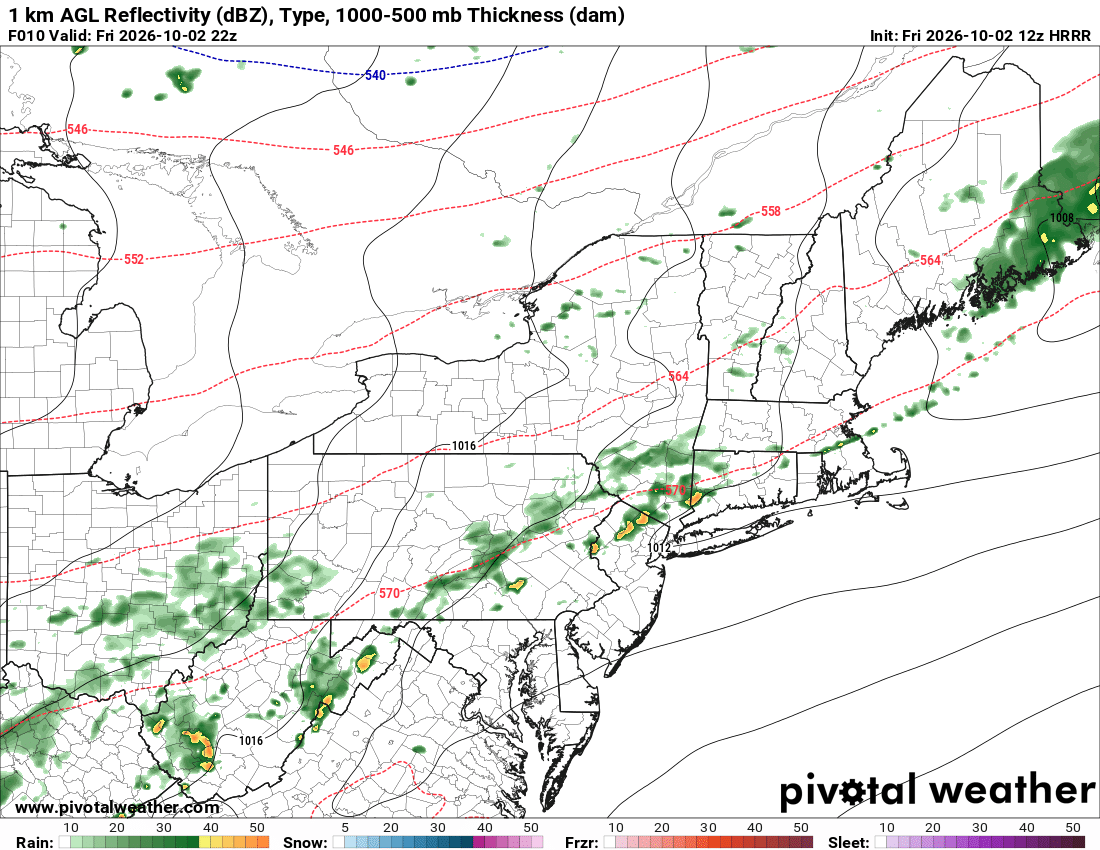
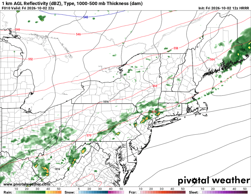
Have to watch for some storms late afternoon
.thumb.png.256fb6298c45dd4fb99f9400f947cb9b.png)
-
I don't think that is the issue...usually the blame arrow points towards the party speaking in absolutes, which is the "no winter" crowd...if you see anyone supremely confident in a great winter, please point them out to me. On the other hand, I see plenty hell-bent on a non-season, which is silly even just considering the intensity of ENSO overlaid onto CC....that position inherently demonstrates a lack of understanding as to the complexity of the implications of CC. As an example....CC has tended to attenuate the influence of ENSO, which we are still seeing to an extent, and has increased intra-season variability. Additionally, the poles are warming faster, which leaves us prone to shorter-term bouts of extreme blocking patters, which always bares watching given the magnitude of the STJ that is anticipated. Obviously hand we are dealt is heavily weighted toward warmth IN THE MEAN, but in no way precludes all hell breaking lose over shorter intervals of time for the reasons discussed.
-
Back in the day whatever the euro has within 72 hours was generally a lock
-
 http://sildendirect.com/# buy Viagra over the counter
 -
Meh,... there's a pathway to getting a surprisingly winter result ( positive snow, assuming that's the consensus). However, that's relative to a shitty background. All the shenanigans that go on here is about 99% guided by individual differences in what reality really is. LOL I suspect those that are "gloom and doom" posting, or are being perceived to be so ( sometimes I think others are also bit too touchy about their d-drip possibly being NARCAN'ed haha ), they are really just being practical. If the limitation on prospects are legit - I don't know. Tough shit. Get over it. It's a separate issue with maturity - mother nature takes the winter candy out of their hand and puts it back on the shelf as we're going through the autumn checkout line. So the kid gets snitty. Meanwhile, there are those that don't seem to really give the limitations equal billing, either. We'll just call them optimists.... To them, it's not so much attempting to be evasive... ? I don't think so. I suspect to them it's a built in assumption. However, that does get a little weighty/bias eventually, given time and crowd physics. There'll be this aroma that smells like false hope that drives posters like Forky to distraction. HAHAHA. One should really preface their missives with something like, "excluding the innate limitations ( or gains ...ether way) that we all know are apparent... like the warmest ever ENSO mapped over the warmest the Earth has been since the late Hadean epoch" (expressive). That way, it's your fault for not fucking reading the conditional statement. Humor aside, CC and warm ENSO doesn't send chills down any rational spine. What those of us that are optimistic are doing is just finding kernels snowcane-reasons lined up on the mirrors. I suspect there's something about the lingering -PDO in conflict with the +ENSO that might be one such pathway.
-
This like another map I saw this morning shows that I’d get within just the next few days at least as much as I got in all of pretty dry Sept., which was ~2.55”. So, I hope it verifies pretty closely for MBY. In reality due to the showery nature of some of this producing isolated heavy amounts, I realize there will likely be significant variations in totals within pretty short distances though.
-
Viagra online price and cheapest viagra buy Viagra online http://www.romeoumc.com/System/Login.asp?id=37949&Referer=https://sildendirect.shop sildenafil onlineand http://bbs.51pinzhi.cn/home.php?mod=space&uid=8395422 buy Viagra over the counter [url=http://images.google.com.ai/url?q=https://sildendirect.shop]Cheap Sildenafil 100mg[/url] Viagra online priceor [url=https://vintage-car.eu/user/vapljbbklj/]buy viagra here[/url] best price for viagra 100mg
-
Electrical/electronic/control systems is all me. That's the stuff I teach. Are you an electrical engineer?
-
fixed
-
i overseeded on labor day. haven't mowed since. it's a jungle out there, mowing tomorrow after I clean up dead sticks that came down over the last 4 weeks.
-
Hey I'm consulting for a SMR job right now. It's onshore though...and I'm only in charge of the electrical/controls part, nothing nuclear-specific.
-
I promise myself not to follow models this winter until 24 hours out. I promise myself not to follow models this winter until 24 hours out. I promise myself not to follow models this winter until 24 hours out. [tries to recover from laughing] I promise myself not to follow models this winter until 24 hours out...
-
Records: Highs: EWR: 96 (2019) NYC: 93 (2019) LGA: 95 (2019) JFK: 95 (2019) Lows: EWR: 39 (1997) NYC: 39 *1886) LGA: 42 (2003) JFK: 43 (2009) Historical: 1858 A hurricane with category 1 winds hit San Diego, CA, the only documented hurricane to strike California in history. This occurred before official weather observations began. Winds of at least 75 mph were estimated based on damage and journalistic accounts. Extensive wind damage to property neared F2 tornado scale damage. Streets were swept clean by heavy rains. (Ref. Wilson Wx. History) 1867: A hurricane struck Galveston, TX with a storm surge that produced $1 million dollars damage. (Ref. AccWeather Weather History) 1882 - An early season windstorm over Oregon and northern California blew down thousands of trees and caused great crop damage in the Sacramento Valley. (David Ludlum) 1882:Louisiana was struck by major hurricane with winds reaching 100 mph and a 12-foot storm surge affecting the coast and bayous. 1,500 people were killed. (Ref. AccWeather Weather History) 1899: Earliest frost @ WBO 33° and 4 consecutive dates rec. 1st - 4th. (Ref. Washington Weather Records - KDCA) 1899: Boston, Massachusetts had a trace of snow today for the earliest recorded snow for the city. (Ref. NOAA Boston Weather Events) 1951: The center of a Tropical Storm crossed Florida from near Fort Myers to Vero Beach. Rainfall totals ranged from 8 to 13 inches along the track, but no strong winds occurred near the center. The strong winds of 50 to 60 mph were all in squalls along the lower east coast and Keys, causing minor property damage. The greatest damage was from rains that flooded farms and pasture lands over a broad belt extending from Naples, Fort Myers, and Punta Gorda on the west coast to Stuart, Fort Pierce, and Vero Beach on the east. Roadways damaged and several bridges washed out. (Ref. Wilson Wx. History) 1953: An unseasonable heat ridge brought record heat from the Plains to the Appalachians. Several locations reported their warmest October temperatures on record including: Evansville, IN: 94°, St. Louis, MO: 94° (later tied), Springfield, IL: 93° (later tied), Louisville, KY: 92° (later tied then broken), Platteville, WI: 91°, Mondovi, WI: 90° and Duluth, MN: 86°. (Ref. Additional Temperatures Listed On This Link) 1959 - A tornado struck the town of Ivy, VA (located near Charlottesville). Eleven persons were killed, including ten from one family. (The Weather Channel) 1963: Hurricane Flora moved across the south coast of Haiti and then meandered across eastern Cuba for the next 5 days, lashing the island with winds of 100 mph or more for at least 100 hours. Astronomical rainfall amounts as much as 90 inches were reported near Velasco. More rain was reported at Guantanamo Bay from Flora than was reported during the entire year of 1962. Flora remains the 2nd deadliest hurricane ever in the Atlantic, with over 7,000 deaths. (Ref. Wilson Wx. History) 1980: Several locations reported all-time October high temperature records including Palm Springs, CA: 116°, Borrego Springs, CA: 113 °F (This record was tied the next day), Yuma, AZ: 112°, Medford, OR: 99°, Eugene, OR: 94°, Blue Canyon, CA: 88° and Astoria, OR: 85°- since tied. (The Weather Channel) 1980 - The temperature at Blue Canyon, CA, soared to 88 degrees, an October record for that location. (The Weather Channel) 1981 - Severe thunderstorms raked Phoenix, AZ, with heavy rain, high winds, and hail up to an inch and a half in diameter, for the second day in a row. Thunderstorms on the 1st deluged Phoenix with .68 inch of rain in five minutes, equalling their all-time record. (The Weather Channel) 1987 - A fast moving cold front produced snow flurries from Minnesota to the Appalachian Mountains, and gale force winds behind the front ushered cold air into the Great Lakes Region. Valentine NE reported a record low of 25 degrees. Temperatures recovered rapidly in the Northern High Plains Region, reaching the lower 80s by afternoon. Jackson, WY, warmed from a morning low of 21 degrees to an afternoon high of 76 degrees. (The National Weather Summary) 1988 - Early morning thunderstorms in Georgia produced three inches of rain at Canton and Woodstock. (The National Weather Summary) 1989 - Flooding due to thunderstorm rains in the southeastern U.S. on the last day of September and the first day of October caused the Etowah River to rise seven feet above flood stage at Canton GA. Thunderstorms produced up to ten inches of rain in northeastern Georgia, with six inches reported at Athens GA in 24 hours. One man was killed, and another man was injured, when sucked by floodwaters into drainage lines. (The National Weather Summary) (Storm Data) 2000: Tremendous rains fell across South Florida due to a developing sub-tropical storm. Miami picked up 12.24 inches of rain in 24 hours and 15 inches in 2 days. The storm would go on to become Tropical Storm Leslie. 2003: Alaska: Temperatures around 70 °F in many Alaska communities set many all-time October maximum records by as much as 17 °F. In Chalkytsik, the high of 75 °F broke the old record by 16 F degrees. Other daily record highs included: Fort Yukon: 70°, Fairbanks: 70°, Homer: 60° and Bettles: 57 °F. (Ref. WxDoctor)
-
71 / 65 warmest day for a while mid - upper 80s in the warmest spots. Clouds / showers into WPA could push east by this evening otherwise a sunny warm day. Weekend split nice Satruday - cloudy and showery Sunday. 10/5 - 10/10 overall near normal beyond there ridge into the east with overall warmer into mid month.
-
Cottonelle soft weenies.
-
it's also funny because it's effective many weak weenies in this forum
-
lawn is def. not stressed, hope we get to mow late today
-
We have some stressed trees here, but I did notice the typical maples are kind of vibrant this year too.
-

2026-2027 Record-breaking El Nino
SnoSki14 replied to Stormchaserchuck1's topic in Weather Forecasting and Discussion
I'm bracing for impact. My only hope is that the Super Nino and PDO act as deconstructive forces that somehow allow us to see wintry weather.







.png.5c4235bf0294da5b5040ffcea1242666.png)