All Activity
- Past hour
-
Hechinger's

-
A lot of energy guys more bullish after first week of December. Seem to think weeklies aren’t out to lunch. Hopefully they’re right.
- Yesterday
-
We'll want to eradicate those lower heights near AK as we get deeper into November....lots of low heights up there over the first half or 2/3rds of November on the ensembles and weeklies. Euro weeklies have been insistent on pushing them out by late November, which would be a good sing for a fast start, but always watch for the delayed pattern shift. Sometimes it's rushed.
-
The only problem is these cold shots are always outdone by the warmups. Even without a ridge over the northeast it seems like our base state is slightly above normal. Feels like it takes a lot to get some colder air lately
-
Some seasons I’m sure different, but between further north latitude out east, less development and longitude I’d say yes
-
Mt Pleasant, CMU student?
-
Over the past 30 years? Maybe I'm just bitter but I remember a large number of coastals that destroyed LI and only grazed NYC during the last 20 years, has the difference always been that much?
-

-


-
I lived in SF for five years, 1990 - 1995. Squad Valley was where we went, when we did. Enjoy, it is...sick out there.
-
Upton and areas out there average at least 5” more.
-
Mountains get a decent hit and it’s cold enough something might fly over. it’s nice to even be looking
-

2025 Atlantic Hurricane Season
WxWatcher007 replied to BarryStantonGBP's topic in Tropical Headquarters
-
And it's a bit early to really see snow chances in NYC (not unheard of), just early.
-
Not that much more, only a few inches I think. Does North Shore have an updated version of his snowmap I wonder?
-
Long Island averages more snow than NYC. Not weird at all.
-

E PA/NJ/DE Autumn 2025 Obs/Discussion
Hurricane Agnes replied to PhiEaglesfan712's topic in Philadelphia Region
Yesterday I bottomed out at 37, the coldest since April 12 IMBY, with a high of 61. This morning's low was a bit warmer at 42 and I made it up to 58 for a high after the cloud deck broke up. Didn't get any of the precip that had been moving north this morning, but exited to the northeast before it got all the way here. Currently 52 with dp 48. -
Worth noting one record set at NYC in October was daily rainfall on Oct 30, 1.83" replaces 1.64" (1917). Now that's a good year to be copying, right?
-
 The best city in the country. The heart of America and the home of the Birds
 -

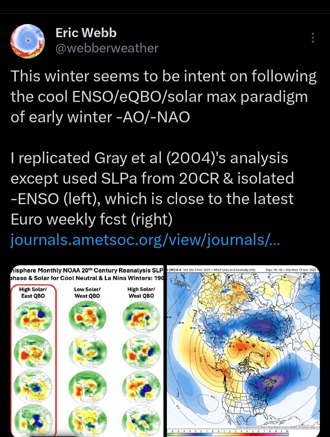
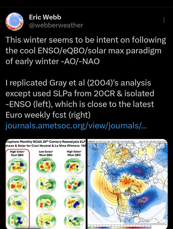
2025-2026 ENSO
40/70 Benchmark replied to 40/70 Benchmark's topic in Weather Forecasting and Discussion
Well, regardless of the semtnics of the MJO criteria, we agree on that general point. -
So low for NYC but more for LI ? Weird
-
Yep Epo and pna are king
-

Fall 2025 Medium/Long Range Discussion
Roger Smith replied to Chicago Storm's topic in Lakes/Ohio Valley
I posted these ideas in other subforums ... I could see this being a highly variable winter with some potent cold shots, flow generally about 260 to 290 deg most of the time, so lake effect quite powerful at times, probably the sort of pattern that could relax to allow coastals once or twice. In the mix would be some +7 to +12 F spells of mild Pacific sourced air masses, even super-cold patterns like 1917-18 and 1933-34 had some milder spells (in fact Jan 1934 was much milder than both Dec 1933 and Feb 1934). So a warmer climate version of those kinds of winters, possibly 1970-71 or 1983-84 could be similar? Not as mild as recent winters and not an all-time cold although one spell could produce a few record cold days. Snow would be lucky to get to near normal but seems unlikely to fall below 50% of normal in northeast coastal regions, probably a bit above normal interior New England. and would add more specific to this region, one or two blizzards likely on tracks from Nebraska to n MO to s IN-OH, frequent strong lake effect downwind of L Michigan and L Huron, very large temperature oscillations likely as Pacific mild and arctic cold air masses alternate in a fast flow with frequent alternations but one or two spells of deep cold centered on the Midwest region. Yours may be the "it" sub-forum for winter 2025-26. Could be similar to that recent winter when MLI, MSP set snowfall records? was that 2020-21? I recall it from snowfall contests we used to have in this subforum. -
 Looks like I’ll finally fall below 32. Probably comes with some type of snow or squall event
 -
Thursday thru noon . Basically 50-65 mph from say 2:00 AM- noon