All Activity
- Past hour
-

January 2026 regional war/obs/disco thread
SnoSki14 replied to Baroclinic Zone's topic in New England
Agreed. It's too soon for us to benefit. I'd be shocked to see much snow prior to late Jan. If anything does come before then consider it a huge bonus. -

Mid-Long Range Discussion 2026
WinstonSalemArlington replied to BooneWX's topic in Southeastern States
-

January 2026 regional war/obs/disco thread
Torch Tiger replied to Baroclinic Zone's topic in New England
aigfs much more reasonable looking -
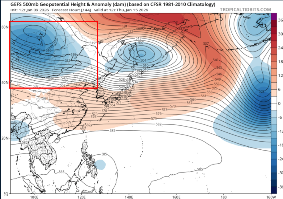
You can teleconnect with what the GEFS shows into East Asia,while you have some possible winter in the long range,this should just be transient cold and a warm up afterwards.But this is also with the MJO related sorta speaking So this is gonna crash the good PNA as heights lower into Russia/Mongolia
-

January 2026 regional war/obs/disco thread
40/70 Benchmark replied to Baroclinic Zone's topic in New England
F^ck that. Next- -
Thats only part of the equation much more complicated than that.
-

January 2026 regional war/obs/disco thread
Go Kart Mozart replied to Baroclinic Zone's topic in New England
LBIMF, too bad it is likely fiction: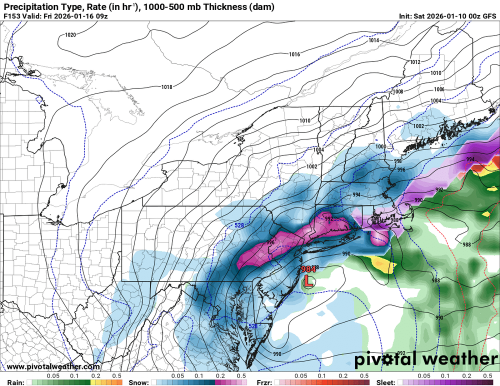
-
Doesn't mean it will snow though. A CMC depiction is more likely. In fact until the MJO circles back around I wouldn't be surprised to see little snowfall until late Jan.
-
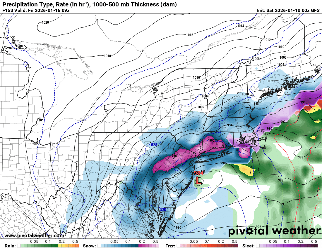
Downslope city on the first one. Ultimately the most likely outcome in my neck of the woods with the energy diving so straight north/south instead of swinging around. Not a bad look for some though. And we just can’t have that energy getting stuck out west of the Rockies for the 2nd one.
-
Gem looks like it may have lost storm 2. Vort is almost gone at 180hrs to a strung out mess.
-
Yep more changes ahead
-
Winter 2025-2026 Offers Return to Normalcy
40/70 Benchmark replied to 40/70 Benchmark's topic in New England
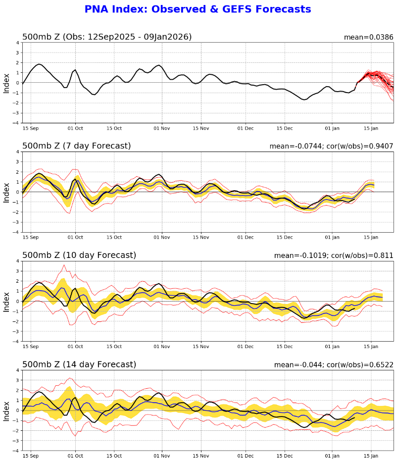
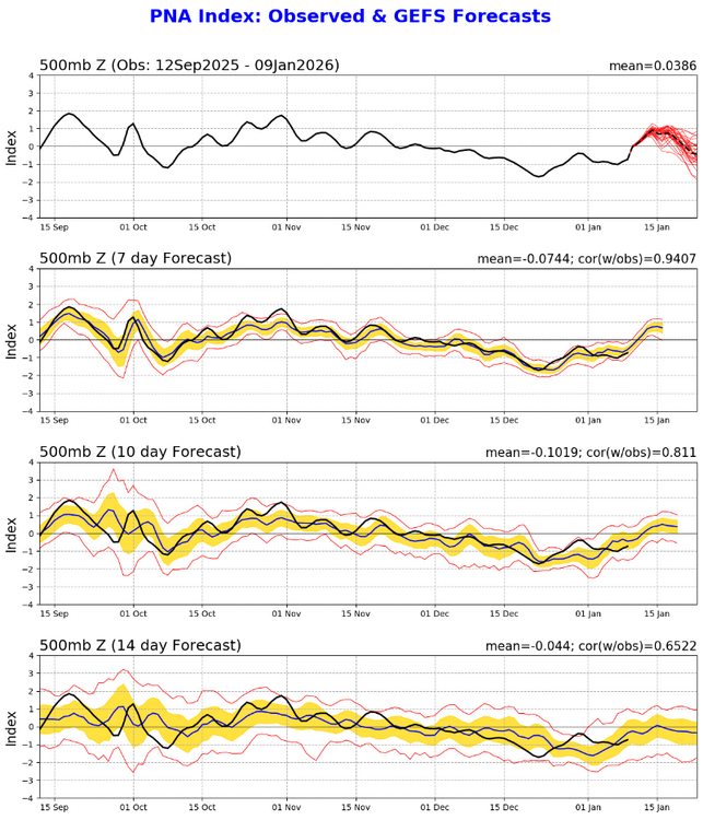
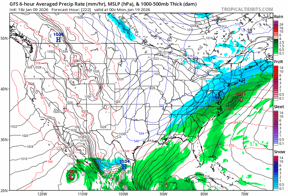
Winter Poised To Return Next Week As Scheduled Increasing Storm Risk Will Accompany Colder Pattern The Descent & Stretching Of Polar Vortex It was reiterated by Eastern Mass Weather last week that a positive TNH pattern would begin to establish itself around the middle of the month, which is a theme that has been consistently advertised list last fall. It was asserted that this new pattern would stabilize by approximately January 20th, at which point a slew of moderate winters storms would ensue as the PV meanders in the general vicinity of James Bay. This +TNH configuration is clearly materializing by early next week, with a colder resurgence accompanying the establishment of the PV near James Bay, Canada, and the first of probably sequence of winter storms organizing. Although the +TNH pattern is often accompanied by lower heights out west given the tendency for southeast ridging, the expectation from Eastern Mass Weather was that the development of a +PNA configuration would ensue during the month of January in conjunction with this pattern, and that is exactly what is poised ensue. As it turns out, it is the precise evolution of this PNA ridge out west that will have major implications on what exactly materializes on the east coast late next week and into the weekend. West Coast Ridge Crucial To Coast Storm Threats Next Week The current interval of RNA that began near the end of November has been a very prominent and protracted one indeed, having persisted for approximately six weeks. Eastern Mass Weather used history as a guide last fall in positing that the consistently negative PNA values from December would give way to a mean positive PNA in the mean during the month of January. This notion was recently buttressed by data provided by Don Sutherland of Americanwx forums, which indicated that 10/10 -PNA streaks of 35 days or greater during the months of November-December since 1980, have averaged positive over the subsequent 30 day period. Data Courtesy of Don Sutherland While guidance has been slow to adjust to this notion, it has, and there is is evidence that is continuing to do so even as the PNA finally recovers to positive values today. Note that the guidance from just one week ago had the RNA returning as early as the 15th of January, which Eastern Mass Weather correctly identified as incorrect. Sure enough, the most recent data indicates that this transition has now been delayed 4 days to January 19th. This an internal part of the forecast for the +TNH pattern that is becoming established for the latter half of January because the addition of a +PNA in this type of pattern will increase the likelihood of significant, and perhaps even major east coast cyclogenesis, as opposed to the traditional overrunning type of precipitation events that typically rule these sort of regimes. This is due to the fact that southeast heights are often elevated enough to compress the flow when abutting against the colder, lower heights south of the PV over the Northeast, which shears storms. However, this is mitigated largely neutralized by the PNA. This trend for a more protracted period of PNA is likely to continue given that the MJO will be approaching phase 7 at a relatively high amplitude just beyond the 20th of the month. This particular convective forcing regime across the tropical Pacific will constructively interfere with the amplification and maintenance of west coast ridging for the vast majority of the balance of January, despite what guidance currently implies. Note how crucial the position and orientation of said ridge is to the evolution of the potential interval of storminess along the east coast late next week. The first wave of energy on Friday is unlikely to coalesce quickly and proficiently enough to yield a major storm given the location and especially the orientation of the the west coast ridge, as was the often the case last season. However, the western ridge positions itself in a manner that is more favorable for significant northeast US storm impacts by next Friday, as the predecessor ocean storm exits stage right. The region is poised for the first in what is likely to be a series of winter storms with MJO assist next weekend, although precipitation type issues are likely to join the fray with subtle retreat of the PV. More updates to follow this week. -
Wow!!
-
Just do like most of us do...look to the left, see the avatar and just scroll past accordingly
-
Go to bed happy and enjoy what you saw tonight or enjoy what you may see tonight.
-
January 2026 regional war/obs/disco thread
40/70 Benchmark replied to Baroclinic Zone's topic in New England
https://easternmassweather.blogspot.com/2026/01/winter-poised-to-return-next-week-as.html -
Agreed!!! The second storm is over 200 hours out. We got plenty of time for that. Need to nail down the first storm before worrying about the next one lol
-
lol

-
Mid-Long Range Discussion 2026
WinstonSalemArlington replied to BooneWX's topic in Southeastern States
-
Fully expecting to wake up to angry @Ji posts that the gfs 6z took away 20" of snow.
-
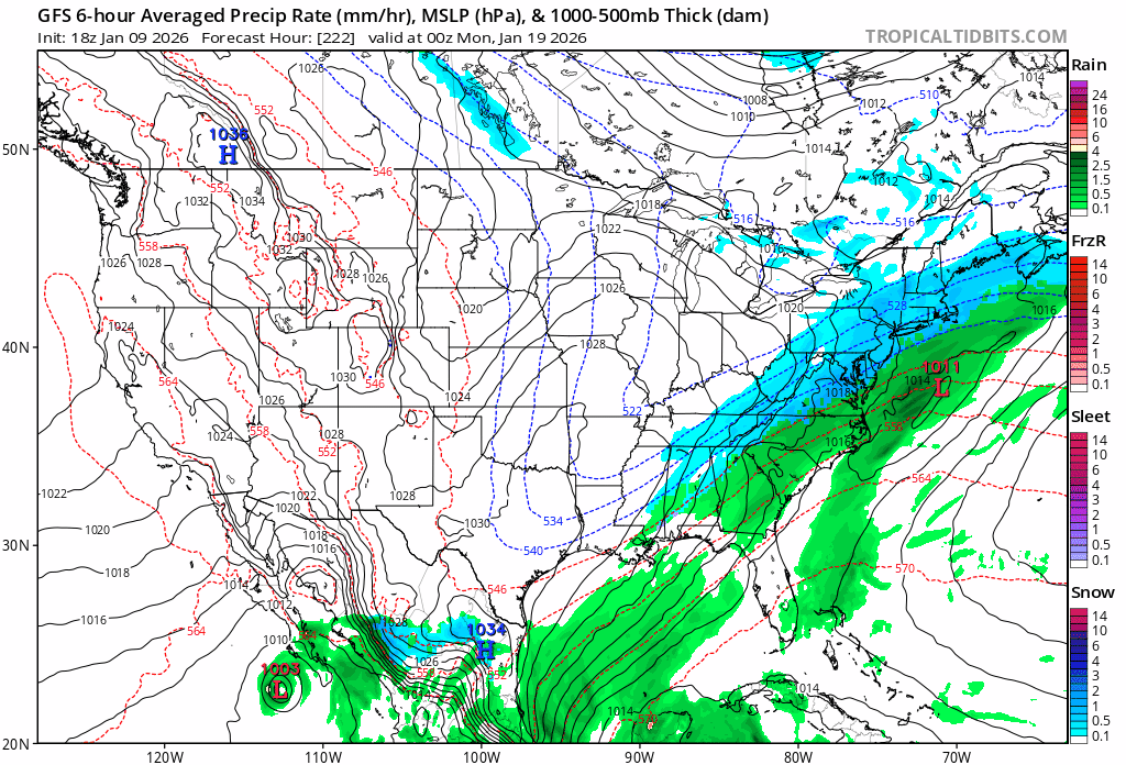
Totally opposing solutions GFS and Canadian
-

January 2026 Medium/Long Range Discussion
NorthArlington101 replied to snowfan's topic in Mid Atlantic
To say the obvious, we gotta get through the first storm first. And we’ve got 3 days at minimum til we can feel like we’ve got that one even sorta figured out -
Here's a picture of the tech running the GFS tonight (it's either this or Intern Roy).

-
18z and 00z couldn't be any more different lol
-

Winter 2025-26 Medium/Long Range Discussion
sbnwx85 replied to michsnowfreak's topic in Lakes/Ohio Valley
Hyper-local but the lake effect potential in NW Indiana looks real impressive Wednesday and Wednesday night. Michigan City to the IL/IN state line look like the early target.