All Activity
- Past hour
-
Flood Watch #5 in the last 30 days was issued for Augusta County at 8:07 am. With the first 4, I only averaged .29" per Watch. Hopefully, #5 will yield pay dirt.
-

July 2025 Discussion-OBS - seasonable summer variability
bluewave replied to wdrag's topic in New York City Metro
Impressive to see the dew points approaching 80° up on Cape Cod. https://www.weather.gov/wrh/timeseries?site=KPVC&hours=72 Jul 15, 12:05 pm 81 79 -

July 2025 Obs/Disco ... possible historic month for heat
powderfreak replied to Typhoon Tip's topic in New England
People would think the world is ending. +2 no one notices… -2 would be like why is it so cold? -

July 2025 Obs/Disco ... possible historic month for heat
weatherwiz replied to Typhoon Tip's topic in New England
Gotta kill them before they kill us. Ticks could become the next cockroach and they could join sides and we'd be in trouble. -
 Yes, I'm aware of that. That's why I noted the difference between the PNS (2.95") and the climate record entry (3.38").
 -

July 2025 Obs/Disco ... possible historic month for heat
dendrite replied to Typhoon Tip's topic in New England
People spray for ticks too? Terrible. Let’s just kill everything. Not scolding anyone here…I just hate what we’re doing to the environment and insects. -
July 2025 Obs/Disco ... possible historic month for heat
weatherwiz replied to Typhoon Tip's topic in New England
We would probably need a summer like 2008 where we're dominated by cold pools. -

93L – “Inactive” Season Posting Check-In
Kevin Reilly replied to BarryStantonGBP's topic in Tropical Headquarters
Exactly what I was thinking. We are right now at 50/50 I think in regards to development of something significant say depression or Dexter once the middle level vortex emerges off the west coast. Now because it’s a mid level circulation it should have no issue making it across down I-4 in central Florida to the gulf time wi tell. -

July 2025 Discussion-OBS - seasonable summer variability
steve392 replied to wdrag's topic in New York City Metro
Really hoped the rains woulda cooled things off or at least make it comfortable outside. Says 79 but feels wayyyy hotter and very sticky again. -

July 2025 Discussion-OBS - seasonable summer variability
Stormlover74 replied to wdrag's topic in New York City Metro
Well no I'm right in the city. But tonight I'll be in Wyoming -
 FWIW White Plains Airport (HPN) and Westchester County Airport are the same facility. Located in Westchester County, New York, it serves the surrounding area including the city of White Plains. It is often referred to by both names.
 -
 Looks like Island Park got drenched. 2.5” pixel there. Long Beach got a good soaking as well. Great-they need all the rain they can in the summer down there.
 -
 The water never gets as warm as the land on a sunny summer day. But as we get later into the summer that effect is less and less pronounced. With less solar insulation and water temps at maximum the sea breeze mechanism is muted. Plus you generally have the highest PWAT potential in August.
 -
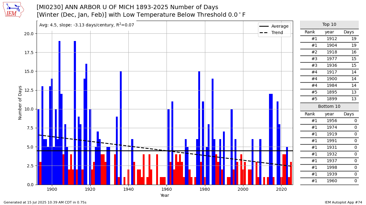
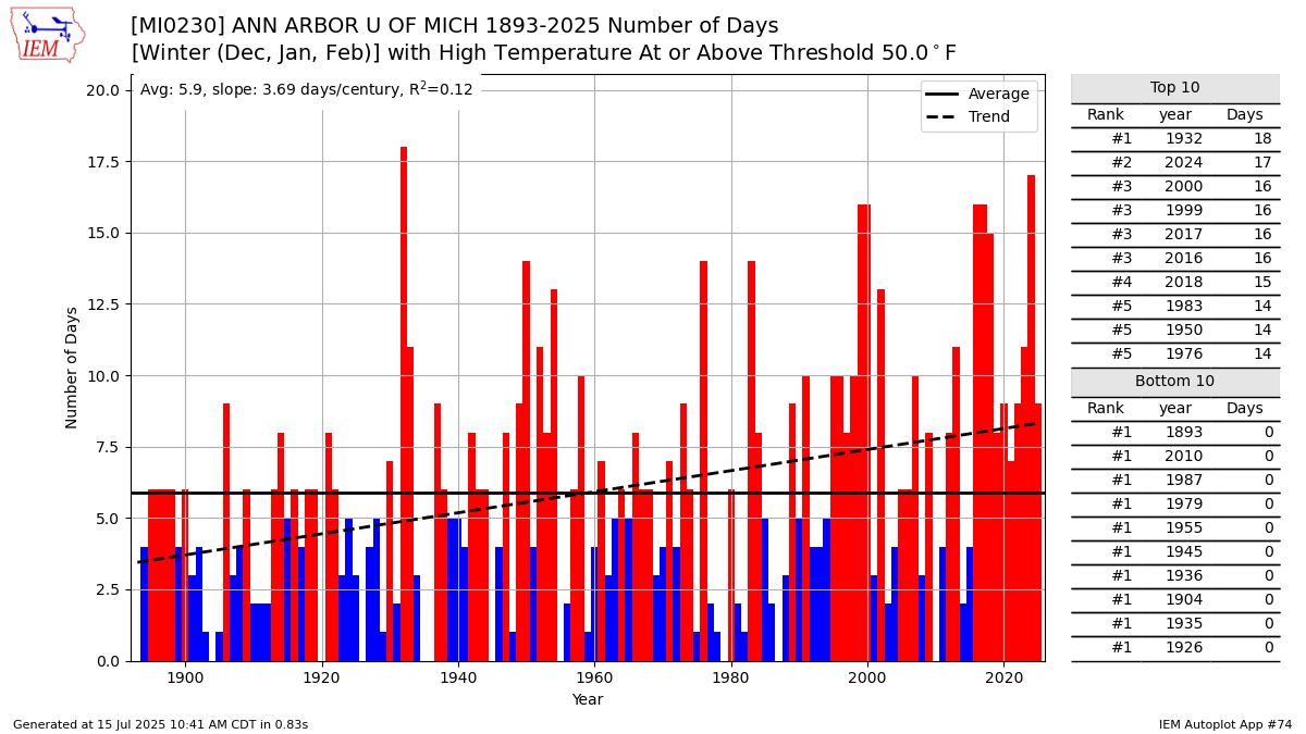
Steady decline in winter below 0° low temperatures. While the 50°+ winter highs have increased at even a faster pace. So Ann Arbor is representative of many other areas.


-

Mountain West Discussion
mayjawintastawm replied to mayjawintastawm's topic in Central/Western States
Super dry at our house this month, with only 0.02" rain- all the storms have gone north and south. Hoping for monsoon moisture to finally hit us a bit over the next week! -

93L – “Inactive” Season Posting Check-In
GaWx replied to BarryStantonGBP's topic in Tropical Headquarters
Perhaps the strong ICON runs from yesterday and the day before were because they were latching into the further SSW mid level circ. -
I was driving from Hunt Valley to my girlfriend's farm in Fallston at 6 pm yesterday when the storm blew up. Absolutely harrowing drive, the rainfall rates were ridiculous and almost continuous ponding on the roadways. Trees down on the way etc. Lightning was quite a show. The rain gauge at the farm I set up a few months ago recorded 1.92" as of 8:00 pm last night in the preceding 24 hours - I think about 1.4" of that in the storm from 6:00 - 8:00. Just under 7 inches of rain at the farm there since we set up the gauge in mid-May. Been really nice for the flowers (that's her crop - cut flowers for sale direct to individuals and flower shops). The zinnias are absolutely exploding right now, as are the dahlias.
-
we've mostly stayed above 75F for an extended period of time.
-
93L – “Inactive” Season Posting Check-In
Kevin Reilly replied to BarryStantonGBP's topic in Tropical Headquarters
It will be interesting to see what models do keep in the back of your mind there are two distinct circulations models will have to sift out which is the circulation to track. If they latch onto the northern circulation they will naturally not show much of anything. The true circulation well south-southwest 100 miles or so could just burrow to the surface and take over for development next 36 hours. -
July 2025 Obs/Disco ... possible historic month for heat
powderfreak replied to Typhoon Tip's topic in New England
Persistence has been a very good forecasting method for like 3-4 summers in a row now. It will be something if we can ever pull off a full summer month of like -2 again. -
-
Well we didn’t have the 5-7+ inch totals over NJ and the Hudson Valley, and the radar clearly showed the storms collapsing as they went east of the city. They essentially rained themselves out over LI. August is typically when we have our higher end rain events likely because the waters are warmest then.
-
93L – “Inactive” Season Posting Check-In
Kevin Reilly replied to BarryStantonGBP's topic in Tropical Headquarters
Looks like a low level circulation moving west towards Jacksonville that will move inland into SE Georgia. The mid level circulation moving west through central Florida will head west and emerge just north or near Tampa then we watch and wait for developments. As you said it’s a pretty robust circulation and once pressures fall in the gulf it can and will develop. Regardless 2-4” of rain all along the path of this system maybe more depending on development especially for the central gulf coast. -
July 2025 Obs/Disco ... possible historic month for heat
weatherwiz replied to Typhoon Tip's topic in New England
Outside of any days with extensive cloud cover or precip it's an above-average pattern, which will be further fueled by what would be warm/humid overnights. But days with abundant sunshine is going to be lower-to-mid 80's for higher elevations and coast and mid-to-upper 80's inland with the warmest days getting into the lower 90's. -

July 2025 Discussion-OBS - seasonable summer variability
LibertyBell replied to wdrag's topic in New York City Metro
wow you're out there now? the nights must be absolutely awesome and with no light pollution and lots of stars!