All Activity
- Past hour
-
 79 / 67 . Continued warm, partly cloudy. Isolated showers mainly South/West, Mid 80s to 90 in the hot areas. Weekend looking great for i think mostly 4 in a row now. Split warm saturday mid 80s / upper 80s , Hot / Humid Sunday low - mid 90s, perhaps some 96,97 in the hottest areas, only isolated showers ot storms possible. Onshore flow Monday NE flow keeps it coolers upper 70s / low 80s or perhaps some midnight/1Am highs Sunday overnight into Monday. Erin hooks northeast mid week. Week is near normal overall with onshore flow and scattered showers Wed/Thu mainly west of the areas as forecast. Warmer by the end of the week and into next weekend briefly with perhaps next shot at 90 Sat or Sun. Ridge west trough into the GL/NE with cooler period the following week. Ridging coming east by the close of the month with warmer - hotter flow. 8/15 - 8/17: Warm - Hot/ Humid - Heat Sunday - only isolated/scattered storms 8/18 - 8/22 : Near normal - cooler than normal Erin east 8/23 - 8/24 : Warmer weekend perhaps a 90 in the hottest areas 8/25 - 8/28 : Cooler 8/29 - Beyond : Ridge builds warmer / hotter flow
 -

Tropical Storm Erin - NOW 70 MPH
BarryStantonGBP replied to BarryStantonGBP's topic in Tropical Headquarters
are people overhyping sinking and dry air? CAM ON ERIN! -
Had several days in the 90s here. At least the week heading into Labor Day looks to warm up.
-
The advisory also said a brief td is possible
-
Last week of the month may try to evolve warmer ...kind of a newish telecon signal.
-
Already not liking the darker earlier mornings and the earlier sunsets...both very noticeable now and it's getting depressing. Not looking forward to the dark by 4:00...unless its snowing out. The thought of having a a snowstorm ongoing and its like 4:30 PM and already dark but its so peaceful and calm with heavy snow is very soothing.
-
any concerns with your well?
-
Jesus Christ it’s a fish storm. You people.
-
Maybe some big un’s
-

Tropical Storm Erin - NOW 70 MPH
hawkeye_wx replied to BarryStantonGBP's topic in Tropical Headquarters
The latest recon pass found the wind north of the center is up to 72 kts at flight level. The shear has abated and convection is now wrapping around the center. It should become a hurricane this afternoon. -

Tropical Storm Erin - NOW 70 MPH
WxWatcher007 replied to BarryStantonGBP's topic in Tropical Headquarters
It’ll get there. It’s organizing, it’s just not pretty. The environment is favorable and if a closed eyewall holds it’ll intensify today and probably take off this weekend. -
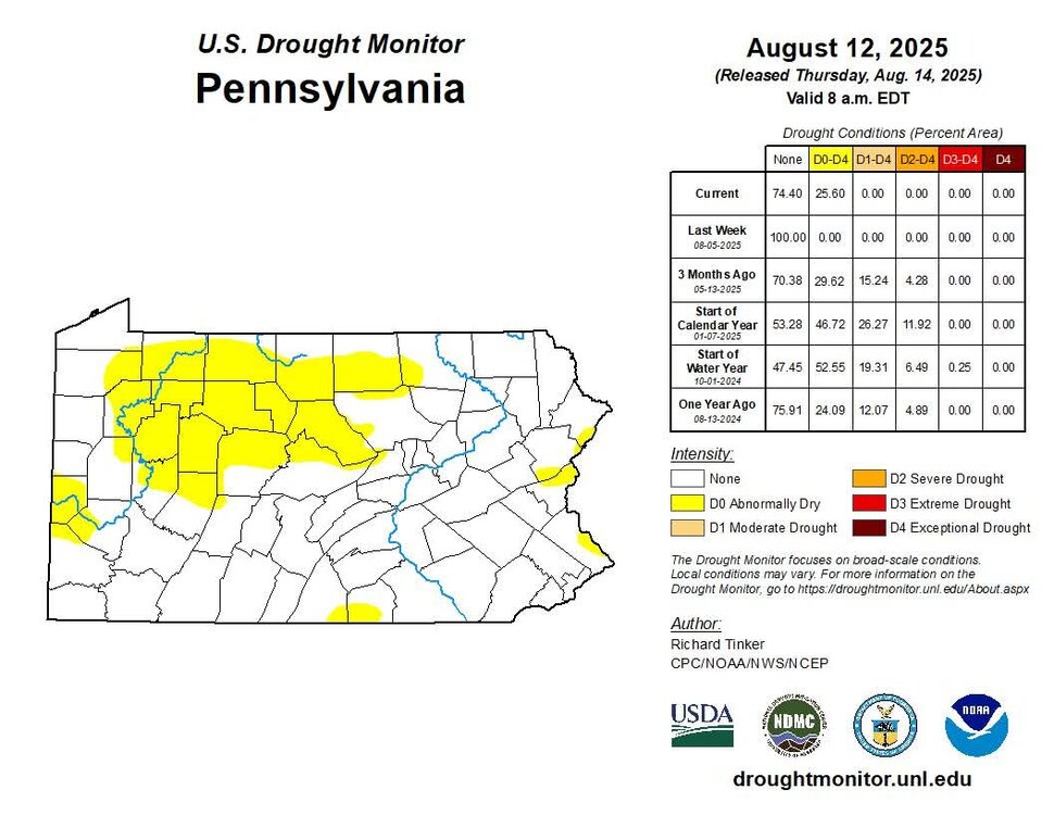
That should get parts of Northern and Western New England moving into moderate drought territory.
-
Tropical Storm Erin - NOW 70 MPH
BarryStantonGBP replied to BarryStantonGBP's topic in Tropical Headquarters
Would you be surprised if this fails to get major status -
National Weather Service State College PA 511 AM EDT Fri Aug 15 2025 PAZ028-036-049-050-052-056>059-063>066-160915- Juniata-Franklin-Union-Snyder-Northumberland-Perry-Dauphin- Schuylkill-Lebanon-Cumberland-Adams-York-Lancaster- 511 AM EDT Fri Aug 15 2025 This Hazardous Weather Outlook is for central Pennsylvania. .DAY ONE...Today and tonight. Slow moving thunderstorms with heavy rainfall are possible this afternoon and evening. The heavy rain may lead to highly localized flash flooding particularly in urban areas and other places that can experience rapid runoff. .DAYS TWO THROUGH SEVEN...Saturday through Thursday. The probability for widespread hazardous weather is low. .SPOTTER INFORMATION STATEMENT... Spotters are encouraged to report significant hazardous weather.
-
This new study really isn’t a surprise given the rapid warming of SSTs in North Pacific. But it’s good to see this new attribution technique correct the climate model errors. Similar shift in the North Atlantic so rapidly warming the climate leads to more persistent -PDO and +AMO patterns. https://www.colorado.edu/today/2025/08/14/human-emissions-drove-megadrought-western-us Greenhouse gas and aerosol emissions from human activity have been driving the prolonged drought in the western United States through a complicated connection with the Pacific Ocean, according to a new CU Boulder-led study. For more than two decades, an extreme dry spell has drained the Colorado River, devastated local farms, and intensified wildfires across the American Southwest. The new prediction, published August 13 in Nature, could help water managers region develop better water use plans or invest in infrastructure accordingly, with relief potentially still decades away. “Our results show that the drought and ocean patterns we’re seeing today are not just natural fluctuations—they’re largely driven by human activity,” said Jeremy Klavans, postdoctoral researcher in CU Boulder’s Department of Atmospheric and Oceanic Sciences and lead author of the study. Worst drought in 12 centuries The drought hitting the Colorado River Basin states and California is directly linked to a climate pattern of the north Pacific Ocean, known as the Pacific decadal oscillation (PDO). The PDO is a natural fluctuation of the Pacific that waxes and wanes every two decades or so. In its positive phase, waters in the eastern Pacific Ocean along the U.S. West Coast tend to be warmer, whereas waters near Japan are colder. In its negative phase, the pattern flips, bringing cold water to the eastern Pacific. Since the 1990s, the PDO has been stuck in a negative phase, an unusually long stretch for a typical cycle, Klavans said. That has had profound impacts on the United States. The cold air and water along the U.S. West Coast hold less moisture than warm air, causing a reduction in precipitation. This extended cool phase also pushed storms that would have brought water to the region farther north. As a result, scientists estimated that about 93% of the western United States is experiencing drought, with 70% facing severe dry conditions. Prior studies have shown that the past two decades have been the driest in the American Southwest in at least 1,200 years. Scientists had long thought that the PDO was entirely determined by natural forces, such as the heat exchanges between the ocean and the air. Even the latest report from the Intergovernmental Panel on Climate Change (IPCC), a body of experts convened by the United Nations, said the PDO is controlled by natural forces with high confidence. If that theory was correct, the PDO should have flipped from negative to positive in 2015 after a strong El Niño event warmed the Pacific. Instead, the PDO shifted positive for a short time following the El Niño before reverting to the negative phase again. New reality To understand why the PDO has been stuck, Klavans and his team used a large collection of climate simulation programs to predict what would happen in the future. Using a new suite of over 570 simulations, the team found that between 1870 and 1950, changes in the PDO were almost entirely driven by internal forces. But since the mid-20th century, greenhouse gas and aerosol emissions have accounted for more than half of the variations in the PDO. The team discovered that existing climate models tend to overestimate the role of internal factors on the PDO while underestimating the influence of external factors, such as emissions. After correcting the imbalance, the team found that emissions, and their impacts on the PDO, have been responsible for nearly all of the precipitation decline in the western United States over the past three decades. “People have been trying for a long time to find out why this part of the country is so dry, and we have an answer for that finally,” Klavans said. Because the same imbalance has been shown in other regions, Klavans said the study’s implications could go far beyond the Pacific. For example, the North Atlantic Oscillation, a similar fluctuation over the Atlantic Ocean, is driving drought in places like Spain. He added that improving climate models to capture the role of external forces could help scientists predict future changes in precipitation across the globe. As for the American Southwest, the outlook is grim. If greenhouse gas emissions continue to rise, the PDO will likely remain in its negative phase, and the drought will persist for at least the next three decades, Klavans said. “With this information, water planners could set new expectations and make proper investments in water infrastructure now, knowing this drought is here to stay,” Klavans said. For example, some Californian cities are already building desalination plants to turn seawater into drinking water. “This study can allow us to better quantify the costs of continued greenhouse gas emissions for Americans,” Klavans said. “That can only help our region plan for a better future.” https://www.nature.com/articles/s41586-025-09368-2 This anthropogenic influence was previously undetected because the current generation of climate models systematically underestimate the amplitude of forced climate variability. A new attribution technique that statistically corrects for this error suggests that observed PDO impacts—including the ongoing multidecadal drought in the western United States—can be largely attributed to human activity through externally forced changes in the PDO. These results indicate that we need to rethink the attribution and projection of multidecadal changes in regional climate.
-
Gonna be some fires next few weeks
-
Tropical Storm Erin - NOW 70 MPH
WxWatcher007 replied to BarryStantonGBP's topic in Tropical Headquarters
998mb with a closed eye per the VDM. Can’t say I recall a system this messy with such a high pressure having a closed eye. -
INVEST 98L - Possible TD before inland later today
WxWatcher007 replied to BarryStantonGBP's topic in Tropical Headquarters
98L is making one final push before reaching the coastline, with deep convection continuing to fire. Radar doesn’t show much organization imo but frictional convergence may help later. -
Late March into June, yes. Then I planted the garden and the spigot was turned off - 1.53" since July 1 and 0.00" since August 1.
-
Air temp no longer matters, how many days above 90F is the “feels like” temperature.
-
Here we go.
-
1.88" overnight, most of which came down in under 30 minutes.
- Today
-
That’s actually perfect. Any sports or outdoor/ yardwork activities and ACATT will be drenched in sweat and swamp each weekend And weekdays they have to work so can’t enjoy the smoke and coc k.
-
Time for some addition now that the Great Heat of August '25 has ended. Days 90° or above at the the majors: Worcester - 0 Providence - 1 Boston - 2 Hartford - 3 (non-consecutive) Anywhere north of route 2 - 447
-
Enjoy your vacation! I’ll look forward to hearing about how it went when you return.


.thumb.png.4150b06c63a21f61052e47a612bf1818.png)


