All Activity
- Past hour
-
40"+ was common N&W of BOS for 78.
-
44/37 currently. 30s tomorrow night likely.
-
Here are a couple: https://journals.ametsoc.org/view/journals/clim/33/11/jcli-d-19-0650.1.xml https://journals.ametsoc.org/view/journals/clim/31/23/jcli-d-18-0159.1.xml
-
The NW wind is crazy this evening. House shaking gusts at times.
-

Invest 92L--70% 2 day, 80% 7 day odds of Development
vortex95 replied to WxWatcher007's topic in Tropical Headquarters
From a strictly climo POV, yes, such a formation in the Bay of Campeche and intensification as a TC to the Gulf Coast happens often, but this climo is a weakness at times for AI models b/c not all follow climo or what would be more typical. -
I read a paper that Paul Roundy had shared in the last couple of years that discussed any known global impacts. Like you said, a lot if it has to be pieced together from written records from individuals in parts of the world in that time frame & then the rest from reanalysis. If I can find the paper I will share it.
-
Invest 92L--70% 2 day, 80% 7 day odds of Development
vortex95 replied to WxWatcher007's topic in Tropical Headquarters
Also, here is the 18z SHIPS output for 92L, The environmental shear is currently moderate and increases w/ time so it is 30 kt by 84 hr. https://hurricanes.ral.ucar.edu/realtime/plots/northatlantic/2026/al922026/stext/26100518AL9226_ships.txt -

Invest 92L--70% 2 day, 80% 7 day odds of Development
Boston Bulldog replied to WxWatcher007's topic in Tropical Headquarters
If Isaias ends up becoming a formidable cane, this would be a significant coup by DeepMind -
 buy levothyroxine online pharmacy and buy thyroid hormone pills online purchase generic synthroid online http://rbcbuffalo.org/System/Login.asp?id=54200&Referer=http://thyrowellrx.com buy synthroid with fast shippingor http://www.sportchap.ru/user/szwfdvvrzj/ synthroid 200 mcg price per pill [url=https://images.google.pt/url?sa=t&url=https://thyrowellrx.com]synthroid 112 mcg online order[/url] generic synthroid for saleand [url=http://ussher.org.uk/user/xnntkyqsrz/?um_action=edit]purchase generic synthroid online[/url] where to buy levothyroxine online
 -
Any hikers or mountain enthusiasts in here willing to chime in on the accuracy of Mountain-Forecast.com for summit conditions or other resources. Some of my nephews are looking into hiking Mt Lafayette in the Whites very early on Saturday morning. They're even talking about trying to summit for sunrise. They're young, healthy, solid hikers but they haven't done winter hikes and I'm making sure they are informed and prepared and honestly trying to talk them out of it. I even texted their mother and told her it's not advisable.
-

2026-2027 Fall/Winter Mountain Thread
Buckethead replied to BlueRidgeFolklore's topic in Southeastern States
Down to 50 here. The leaves have really begun to change here finally...with a noticeable amount of brown already. Sent from my SM-S948U using Tapatalk -
By Saturday it will show Raleigh to expect .25" as usual
-
Invest 92L--70% 2 day, 80% 7 day odds of Development
vortex95 replied to WxWatcher007's topic in Tropical Headquarters
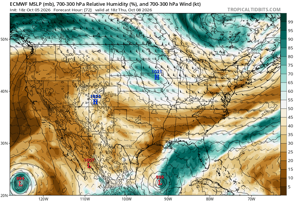
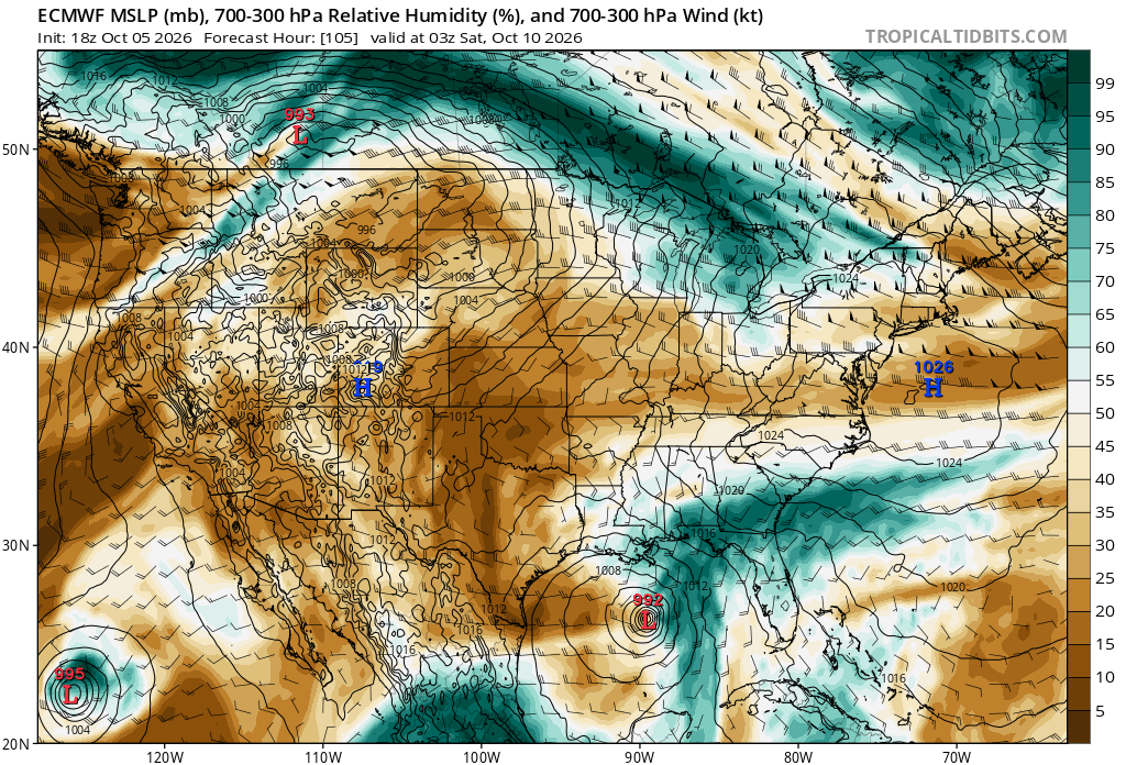
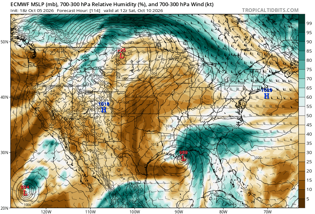
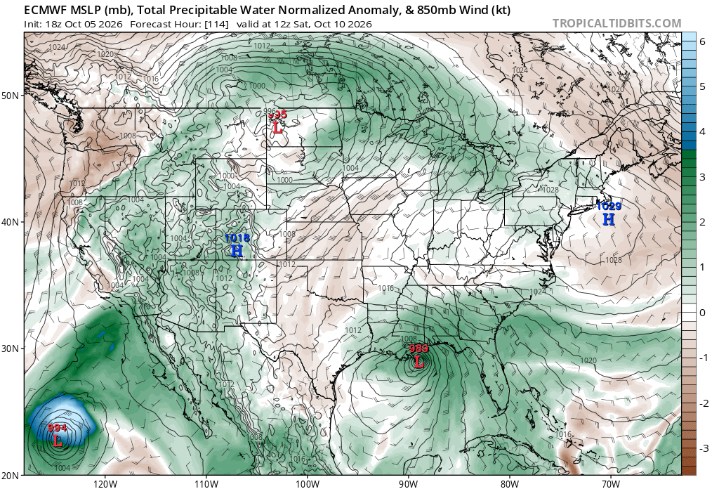
Something doesn't seem right. I was surprised the 18z ECWMF suddenly when the GFS route. But the 700-300 mb RH fields and PWAT anoms tell the story. I attached 18z ECMWF 72, 105, and 114 hr 700-300 RH. Even when it is still the Bay of Campeche, it is "halved" from a strong moisture gradient, and it just gets stronger w/ time. looking like a typical ET low development. And look at the 114 hr fcst PWAT anomaly. That clearly shows a frontal structure, and compare the PWAT anomalies to Simon in the EPAC. That's not nearly the anomaly you'd see in a typical TC. I can see NHC "playing games" here. Calling it something that it is not b/c of non-meteorological factors (social media nonsense, its sensible wx impact, etc). But ET low can and do form in the Gulf in Oct (see the 1992 case I posted about earlier) and given the strength of El Nino, it makes ET lows this early even more likely. In fact, by 36 hr, the 250 mb STJ become quite apparent near the Gulf Coast, and in 5 days close to landfall, a strong 250 s/w is present in the region, obviously aiding in the system's development. Some might go, "but the simulated IR from the GFS shows an eye!" Well, it is the GFS, and yes, initially it could be a TS/STS but here lies another issue, transition to a PT/ET low when it is approaching a landfall. Sandy anyone? You see the problem here. But I say, in the end, it is what is is, and call it as such. Don't let external pressures and nonsense contaminate the met science!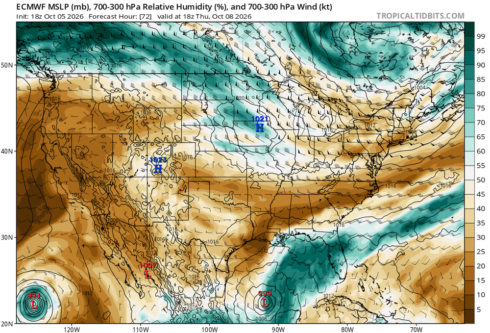
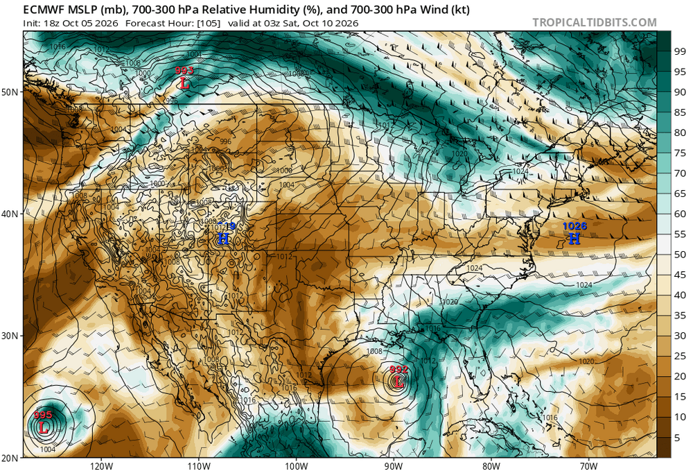
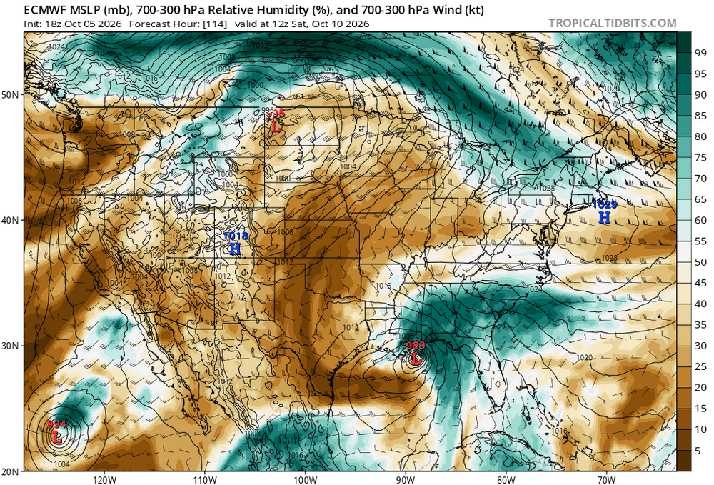
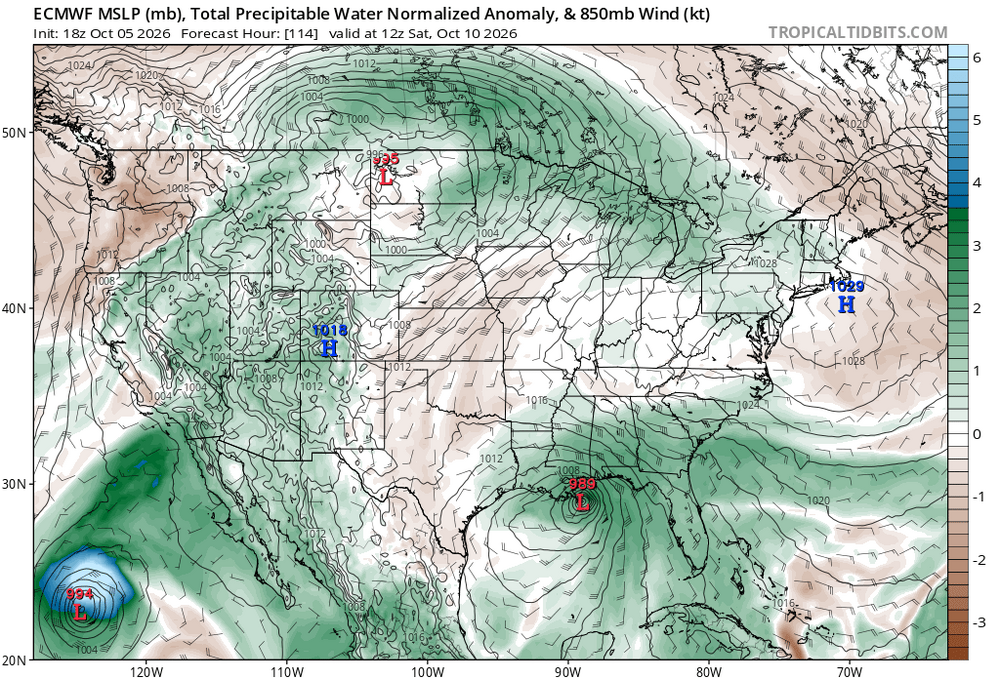
-

2026-2027 Record-breaking El Nino
GaWx replied to Stormchaserchuck1's topic in Weather Forecasting and Discussion
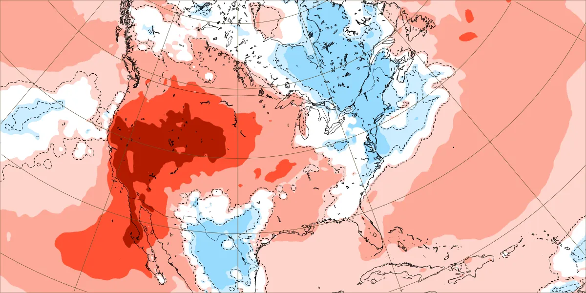
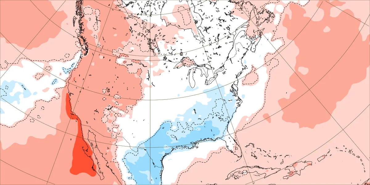
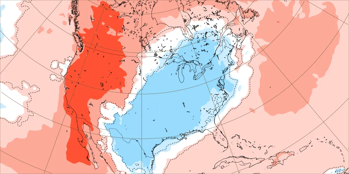
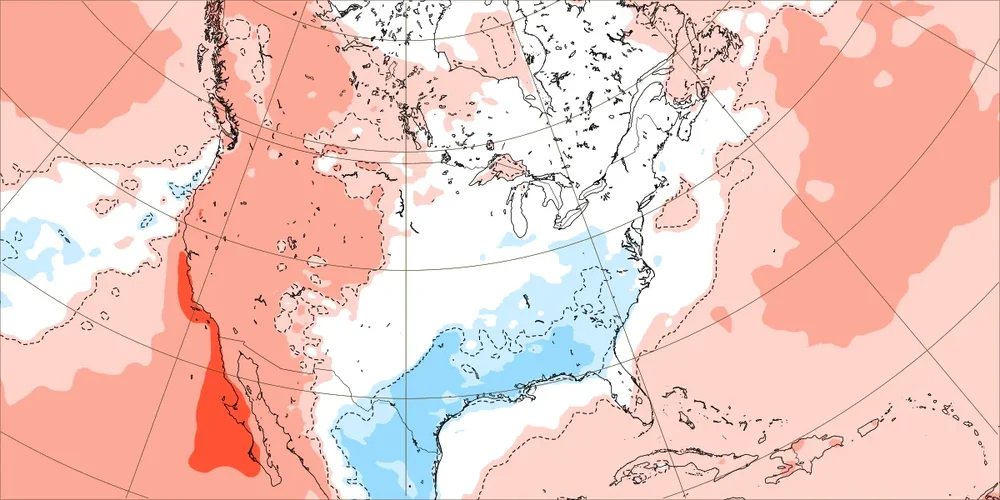
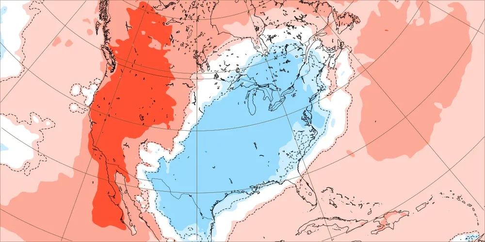
Today’s Euro weekly for 10/5-11 is the final one: Look how much the cold signal for 10/5-11 in the E weakened overall over the last 10 days. However, the signal remained at about the same level in from the NE to down the coast NYC to Hatteras: Sep 25th run for 10/5-11: much stronger cold signal Week 2 (10/12-18) is warm. Just a few days ago it was cool. Other than week 1, the only other cool E weak is week three, 10/19-25: this week has been mainly coolish over the last week of runs: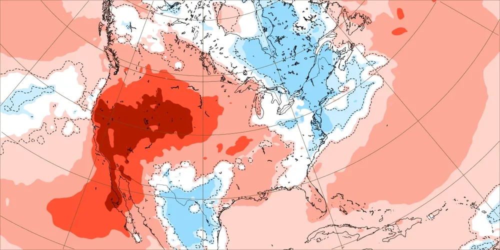
-
The coolest air so far this fall will move into the region tonight. As a result, New York City could see the temperature dip below 50° for the first time this season tomorrow morning. Lows should fall to the middle and upper 40s in New York City on Wednesday morning. Some distant suburbs could see lows bottom out in the 30s. Thursday and Friday will be milder days with the mercury returning to the lower 70s across much of the region. The week will be dry. The next chance for precipitation could be Sunday or the following Monday. The ENSO Region 1+2 anomaly was +5.3°C and the Region 3.4 anomaly was +3.2°C for the week centered around September 30. For the past six weeks, the ENSO Region 1+2 anomaly has averaged +4.63°C and the ENSO Region 3.4 anomaly has averaged +2.92°C. Both ENSO regions have set new all-time records. The ongoing strong El Niño, will continue to strengthen through the mid-fall. The SOI was -21.34 yesterday. The preliminary Arctic Oscillation (AO) was +2.033 today.
-
everybody keeps talking about October warmth… it’s like a bunch of 60s. I just looked to make sure I’m not crazy.. the normal high at this time of year 66°. Next week 50s. What warmth is everybody talking about? Sept was slightly BN. This hasnt been an unusually warm fall so far
-
Leaving work and it's chilly in Kearny!
-

2026-2027 Fall/Winter Mountain Thread
Met1985 replied to BlueRidgeFolklore's topic in Southeastern States
Temp down to 54 degrees currently. - Today
-
I agree, but can’t rule out a solid storm away from the coast. If you are on the coast south of Boston, I think you are porked for snowfall totals.
-
2026-2027 Record-breaking El Nino
GaWx replied to Stormchaserchuck1's topic in Weather Forecasting and Discussion
Today’s NOAA weekly relative ENSO release for last week: 23SEP2026 3.9 3.1 2.2 0.1 30SEP2026 4.5 3.3 2.3 0.1 Nino 1+2 warmed up strongly (0.6) to +4.5! For the week, it obliterates the prior record back to 1981 of +3.5 (1997). It is only barely shy of the all time record for any week of +4.6 (6/29/1983). Nino 3 warmed up by 0.2 to +3.3. That’s a new record high for the week with it beating the +2.8 of 1997. The record for any week is +3.6 (12/29/1982). Nino 3.4 warmed slightly to +2.3. This barely beats the +2.2 of 1982 for the week. The warmest for any week is +2.9 (12/29/82). Nino 4 remained at only +0.1, which in combo with the way warmer Nino 3 and Nino 1+2, makes ‘26 easily the most E based Nino on record. https://www.cpc.ncep.noaa.gov/data/indices/rel_wksst9120.txt -

Winter 2026-2027 Speculation
Prismshine Productions replied to 40/70 Benchmark's topic in New England
Yeah it is going to be warmer, but far from the worst case scenario we were looking at a few months ago Sent from my SM-S176V using Tapatalk -

Invest 92L--70% 2 day, 80% 7 day odds of Development
WxWatcher007 replied to WxWatcher007's topic in Tropical Headquarters
18z Euro is stronger than 12z (about 989mb at landfall), but the AI version is weak. I'm not sure I have a good handle on this one, either. A more northeasterly motion should align enough for some modest intensification, but much like Edouard, it's going to need time to coalesce. The ceiling is a hurricane, but I'm just not sure we get there. But we need a well defined low before hurricane models even get a good handle on things. -

Invest 92L--70% 2 day, 80% 7 day odds of Development
Windspeed replied to WxWatcher007's topic in Tropical Headquarters
The HAFS suites look very realistic as opposed to the overdone operational parent. An assymetric system. The strongest winds may be well in advance of the COC by the time it reaches the coast. -

Invest 92L--70% 2 day, 80% 7 day odds of Development
NorthHillsWx replied to WxWatcher007's topic in Tropical Headquarters
Hurricane Nate from 2017 is a very similar system to what we have here from upper level setup over the gulf during the same time of year -

Invest 92L--70% 2 day, 80% 7 day odds of Development
hawkeye_wx replied to WxWatcher007's topic in Tropical Headquarters
The 18z hurricane models all strengthen this system to the 970s in the central gulf, but then shear and dry air rip it apart as it nears the gulf coast.