All Activity
- Past hour
-
I bagged my first 30C/86F day of 2025 this afternoon, we are crisp dry and overperformed again. This first 30 is early, I think I typically get mine in late May but Ive reached it May 1 in 2015 and almost had it in early April of 2010. Dreamy stretch of blue skies and warmth compared to the wretched start to May I had! RH was 14% at noon, low of 6C/43F.
-
Yeah the rest of the week looks like crap. Hopefully we can salvage at least some of Memorial Day weekend but the pattern isn’t conducive for beach weather either way.
-

Occasional Thoughts on Climate Change
TheClimateChanger replied to donsutherland1's topic in Climate Change
I didn't look at Pennsylvania's Division 3 [Southeastern Piedmont] but I did notice the most recent Julys were showing lower on NCEI's Climate at a Glance than the published figures. -
Occasional Thoughts on Climate Change
TheClimateChanger replied to donsutherland1's topic in Climate Change
Well, at least for Pennsylvania's Division 9, I don't see that trend. Since 1957, 54 years show a cooling adjustment, 10 warming, and 2 years are exactly the same as published. To be honest, the warming of the 1980s appears to be an artifact of a pairwise homogenization adjustment - perhaps some sort of preferential treatment is given to first order stations. It looks like PIT had a warm bias, so the numbers were adjusted upwards a bit to fall more in line with PIT. The adjustment probably should be in the opposite direction, as the mean value is probably inflated from the apparent warm bias. Which is likely partially due to the HO-83, although the warm bias seems to predate its installation. Some of the recent Julys (2020 & 2021) have among the largest "chilling" adjustments. -
Yeah I had me feet in and it stung. If I’m surfing it’s still full suit boots and gloves. Some of those kids are drunk/high. Allot of high schools choose jones beach for senior cut day due to the lack of rule enforcement. I mean, for mine back in 00 we burried a keg in ice the night before. Had the tap sticking out of a hole cut in a beach blanket. Ahhh the good old days.
-
Is it possible anymore to have a day without wind???
-
Sounding just west of South Bend for Thursday evening... Is this worse than posting a 3 foot snow map four days out?
-
N MI, and NE MN are pretty similar in environment, but with more lakes, and swamps. It does tend to get warmer than there, tho, with the air coming in from the W or S out of the plains. N MI is surrounded by the big water. The Lake Superior shore is the same all around.
-
Yeah, things slowly changing, but the biggest problem we have right now is the spruce worm. It's killing a lot of pines. The problem is all over NA. There used to be lots of elms, and birch, but disease wiped them out (mostly out) back in the 80's. S trees won't survive here yet, but if we survive until the end of the century, and trends do continue to warm things up enough, new S species will take root eventually. Aspen (Poplar dominate) around here thrive just fine. They clone themselves through the root system. they are like a weed. If you want another specie in an area that has been cleared, you have to kill them first before planting. They are really hardy, and it will take a lot to see them disappear.
-
I read this wrong because all the really good looking girls would still go out with the guys with a Mohawk cause they've got all the money!
-
Yes south Jersey and southeast PA really need it.
-
That I am not sure about...I know that is the case with the equatorial PAC and ATL but not sure if that is the case off the EC. I would think they are probably to some degree but probably negligible really. I just thought it was a pointless tweet because if SSTAs were 65 versus 45 right now off the EC or early in tropical season, that would have no bearing on increasing/decreasing potential for tropical systems to survive farther north. Hell, if they were 71 versus 45 there still would be no difference. SSTs below 80 are going to have a negative feedback on tropical systems.
-
Yet another Chester County bicker session in the wrong thread. Seems futile to object?
-
Gorgeous day, the clouds have held off. Not going to see another one like this until next Sunday?
-
I hope and wish lol. The longest heatwaves page the NWS has up for NYC really puts things into perspective. I think NYC LGA EWR and JFK all had their longest heatwaves in 1953, 1993 and 1999.
-
Model guidance really waffling. Genuinely wonder if the lack of RAOB data is hurting.
-
The anomalies are greater than recent past no?
-
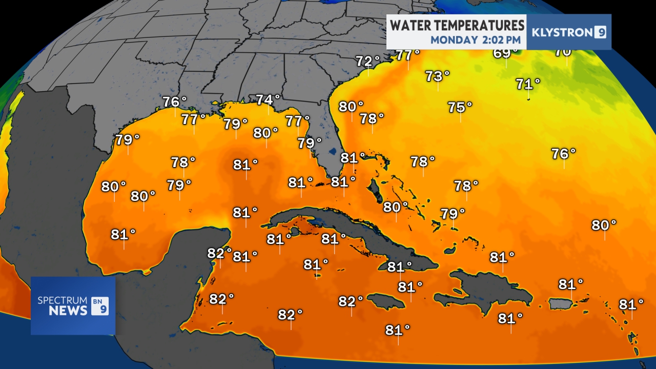
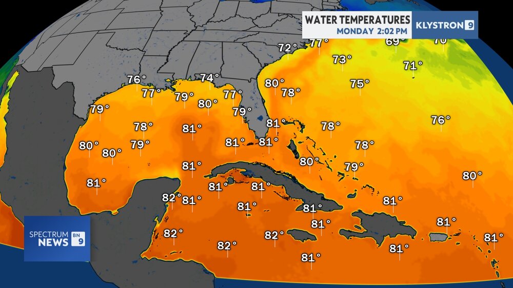
That water can't be more than 50-55 degrees---brrr
-
Rain began at 1:30. I need 3.77" to erase the drought for the year.
-
Yeah something can't be right with that.
-
But that could be said every year then.
-
once conditions get better things could spin up quick.. already in the 80s in a lot of areas https://spaghettimodels.com/
- Today
-
FWIW he did say early in the season
-
Those temps look wild too. It's not in the low 80s SE of HSE and not 43 east of NJ. I don't know what the heck is going on.
-
Flood watch expanded northward and eastward Flood Watch National Weather Service Baltimore MD/Washington DC 125 PM EDT Mon May 12 2025 MDZ501-502-510-VAZ028-031-050-051-053>056-501-502-505-506-526-527- WVZ050>053-503-504-130130- /O.EXB.KLWX.FA.A.0004.250513T1000Z-250514T1000Z/ /00000.0.ER.000000T0000Z.000000T0000Z.000000T0000Z.OO/ Extreme Western Allegany-Central and Eastern Allegany-Eastern Garrett-Frederick VA-Clarke-Orange-Culpeper-Fairfax- Arlington/Falls Church/Alexandria-Stafford-Spotsylvania-Northern Fauquier-Southern Fauquier-Western Loudoun-Eastern Loudoun- Northwest Prince William-Central and Southeast Prince William/Manassas/Manassas Park-Hampshire-Morgan-Berkeley- Jefferson-Western Mineral-Eastern Mineral- 125 PM EDT Mon May 12 2025 ...FLOOD WATCH IN EFFECT FROM TUESDAY MORNING THROUGH LATE TUESDAY NIGHT... * WHAT...Flooding caused by excessive rainfall continues to be possible. * WHERE...Portions of western Maryland, including the following areas, Central and Eastern Allegany, Eastern Garrett and Extreme Western Allegany, Virginia, including the following areas, Arlington/Falls Church/Alexandria, Central and Southeast Prince William/Manassas/Manassas Park, Clarke, Culpeper, Eastern Loudoun, Fairfax, Frederick VA, Northern Fauquier, Northwest Prince William, Orange, Southern Fauquier, Spotsylvania, Stafford and Western Loudoun, and West Virginia, including the following areas, Berkeley, Eastern Mineral, Hampshire, Jefferson, Morgan and Western Mineral. * WHEN...From Tuesday morning through late Tuesday night. * IMPACTS...Excessive runoff may result in flooding of creeks, streams, and other low-lying and flood-prone locations. Low-water crossings may be flooded. * ADDITIONAL DETAILS... - While showers will spread into the area today, a prolonged period of moderate to heavy rain with embedded thunderstorms is expected late tonight into Tuesday night. Rainfall amounts of 2 to 4 inches are likely, with locally higher amounts possible along the eastern slopes of the Blue Ridge Mountains and Alleghenies. This rainfall may lead to scattered instances of flooding. - Please visit www.weather.gov/safety/flood for flood safety and preparedness information PRECAUTIONARY/PREPAREDNESS ACTIONS... You should monitor later forecasts and be alert for possible Flood Warnings. Those living in areas prone to flooding should be prepared to take action should flooding develop.