All Activity
- Past hour
-

October Comes Early: Late September Multi-Hazard Hybrid Storm
Snowedin replied to WxWatcher007's topic in New England
Please send some of that tropical warmth up north. One more day below 70 and these lanky arms are gonna start flying in all directions! -

October Comes Early: Late September Multi-Hazard Hybrid Storm
Bostonseminole replied to WxWatcher007's topic in New England
18z nam looks north of 12z -
ha ha ha... NAM 3K is only 10MB higher this run at hour 10.
-

Central PA Autumn 2026
Mount Joy Snowman replied to canderson's topic in Upstate New York/Pennsylvania
I don't know what you're talking about Buy yeah, seems like a lost season. Gonna be a tough watch this year. The issues are too many to list. As for PSU, really bad news about Koby Howard. Thinking they'll be taking some tough losses eventually too, just hopefully not tomorrow night. Football, what I let it do to me. Aye. -

October Comes Early: Late September Multi-Hazard Hybrid Storm
DirtySnowDen replied to WxWatcher007's topic in New England
This reminds us of Rocktober 2011, where each run came in snowier than its last run. -

Strong Nor'Easter/Hybrid Storm Late September 2026
Snowlover11 replied to Rjay's topic in New York City Metro
Good thing this isn’t a winter storm weenies would be jumping ship see all that moisture off the coast and not moving much. -
Have a drink at Princeton Bar in Avalon for me.
-
 pharmacies in canada that ship to the us [url=https://canamcrosscare.shop/#]Сan Am Cross Care[/url] best canadian pharmacy
 -

October Comes Early: Late September Multi-Hazard Hybrid Storm
TalcottWx replied to WxWatcher007's topic in New England
Better top 25 CFB on Sat. -

October Comes Early: Late September Multi-Hazard Hybrid Storm
WxWatcher007 replied to WxWatcher007's topic in New England
Let him go There should be HWW for the coast, especially SE CT imo. -

October Comes Early: Late September Multi-Hazard Hybrid Storm
Ginx snewx replied to WxWatcher007's topic in New England
Da Raiders -

October Comes Early: Late September Multi-Hazard Hybrid Storm
FXWX replied to WxWatcher007's topic in New England
Agree -
October Comes Early: Late September Multi-Hazard Hybrid Storm
TalcottWx replied to WxWatcher007's topic in New England
Yeah, very windy in Simsbury even at '300 -

Strong Nor'Easter/Hybrid Storm Late September 2026
Prue11 replied to Rjay's topic in New York City Metro
Most likely will be cancelled -
October Comes Early: Late September Multi-Hazard Hybrid Storm
FXWX replied to WxWatcher007's topic in New England
I guess if OKX says it, it must be true; lol -

Chester County PA - Analytical Battle of Actual vs. Altered Climate Data
chubbs replied to ChescoWx's topic in Climate Change
Here's warming since 1850 for the Mid-Atlantic in the new Berkeley dataset. Chester County has similar warming to the region as a whole. The Berkeley warming in good agreement with NCEI, and other groups. https://dashboard.theclimatebrink.com/#map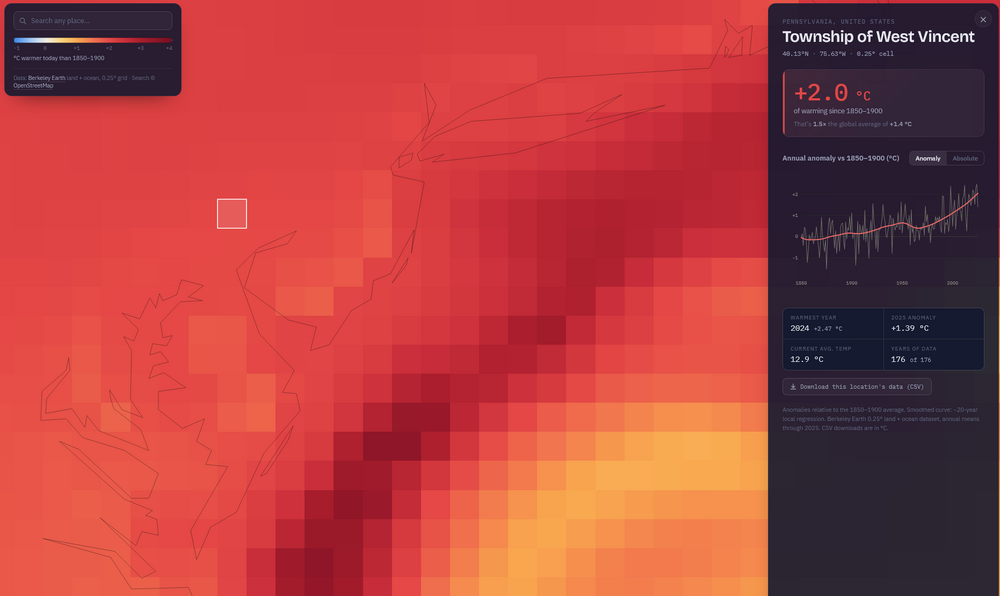
-
October Comes Early: Late September Multi-Hazard Hybrid Storm
FXWX replied to WxWatcher007's topic in New England
Peak here (~1,200') 38 mph -
Damn. Dogfish has me trapped. So good. So fun.
-

Strong Nor'Easter/Hybrid Storm Late September 2026
Big Jims Videos replied to Rjay's topic in New York City Metro
Of course I'm supposed to go to the Yankees game Sunday. -

October Comes Early: Late September Multi-Hazard Hybrid Storm
WinterWolf replied to WxWatcher007's topic in New England
Let’s do it. -

Strong Nor'Easter/Hybrid Storm Late September 2026
NEG NAO replied to Rjay's topic in New York City Metro
starting on eastern long island already BUT the storm is outside the benchmark and crawling will have to make a move westward - might have showers much later tonight around NYC and eastern NJ metro GOES-EAST US PSeUdo-Color LOOP -
reputable indian pharmacies online or indian pharmacy shipping to usa online drug http://www.google.st/url?q=https://geninduspharma.com online drug or http://www.knifriend.com.cn/home.php?mod=space&uid=1699829 indian pharmacy online [url=https://cse.google.co.th/url?sa=i&url=http://geninduspharma.com]buy medicine online[/url] indian pharmacy in usa or [url=http://www.orangepi.org/orangepibbsen/home.php?mod=space&uid=7036965]online drug[/url] lowest prescription prices online india
-
I’ve only rarely seen these very comfy conditions here this early in autumn, especially in recent decades: SKY/WX TMP DP RH WIND PRES REMARKS SAVANNAH ARPT MOSUNNY 75 53 46 N10 30.02F HUNTER AAF SUNNY 75 53 45 N5 29.98F
-
October Comes Early: Late September Multi-Hazard Hybrid Storm
DirtySnowDen replied to WxWatcher007's topic in New England
Old man’s tropical wife died, got a baroclinic pet (new wife) -
Hurricane Polo Discussion Number 20 NWS National Hurricane Center Miami FL EP172026 800 AM MST Fri Sep 25 2026 After regaining Category 5 status overnight, the remarkable satellite presentation of Polo indicates the hurricane has continued to intensify. The eye has contracted and warmed over the past several hours, with temperatures above 20 deg C measured inside the eye. A thick, solid ring of deep convection surrounds the center, with cloud tops as cold as -80 to -85 deg C. There were no indications of a concentric eyewall structure in 0905 UTC AMSR3 passive microwave imagery. The latest UW-CIMSS ADT estimates and a T7.5 Dvorak classification from TAFB support an initial intensity of 155 kt. A NOAA research aircraft mission is scheduled to investigate Polo later today. Polo continues moving westward (270/10 kt) along the south side of a mid-level ridge that extends across northern Mexico. This weekend, a deep-layer trough approaching from the west is expected to erode the steering ridge. This will cause Polo to turn northwestward and northward as it moves around the western side of the ridge. By Monday, the increasing influence of the upper trough should turn Polo northeastward toward Baja California Sur and west-central Mexico. The global models and AI-based guidance are generally in good agreement on this track evolution. The updated NHC track forecast is adjusted slightly to the left of the previous one, and is also a bit slower to come into better agreement with the latest multi-model consensus. Overall, the NHC forecast remains on the faster and right side of the envelope, closer to HCCA and GDMI. Based on this prediction, watches could be required for portions of the Baja California Peninsula as early as Saturday. Based on the aforementioned AMSR3 data, an eyewall replacement cycle (ERC) does not appear imminent. Thus, further slight strengthening cannot be ruled out while Polo remains over very warm waters in a weaker shear environment. The vertical wind shear is expected to increase over the weekend, and because of this as well as the possibility of a future ERC, the NHC intensity forecast shows a weakening trend beginning on Saturday and continuing into next week. Regardless, Polo is predicted to approach Baja California Sur as a strong hurricane early next week, and interests there should closely monitor the latest forecast updates. The NHC forecast remains on the higher side of the intensity guidance, generally following HCCA. Once land interaction occurs with the Baja California Peninsula and mainland Mexico, more rapid weakening is anticipated. Distant moisture from Hurricane Polo and Odalys will be transported into the southwestern United States this weekend and early next week, and may indirectly contribute to a heavy rainfall and flash flood threat in the region. See products issued by the Weather Prediction Center for more information. Key Messages: 1. Polo is forecast to approach the Baja California Peninsula early next week as a hurricane. Interests there should closely monitor the latest updates and ensure that they have their preparedness plan in place. Watches could be required as early as Saturday for portions of the area. 2. Heavy rainfall associated with Polo may begin to impact Baja California Sur late Sunday into Monday. This rainfall may produce life-threatening flooding and mudslides, especially in areas of steep terrain. FORECAST POSITIONS AND MAX WINDS INIT 25/1500Z 17.1N 108.5W 155 KT 180 MPH 12H 26/0000Z 17.2N 109.8W 155 KT 180 MPH 24H 26/1200Z 17.8N 111.5W 140 KT 160 MPH 36H 27/0000Z 18.9N 112.7W 125 KT 145 MPH 48H 27/1200Z 20.4N 113.4W 110 KT 125 MPH 60H 28/0000Z 22.0N 113.7W 100 KT 115 MPH 72H 28/1200Z 23.8N 113.4W 95 KT 110 MPH 96H 29/1200Z 26.9N 110.8W 70 KT 80 MPH 120H 30/1200Z 30.4N 106.5W 30 KT 35 MPH...POST-TROP/INLAND $$ Forecaster Reinhart