All Activity
- Past hour
-
I'm always fascinated by their radiating... considering they are close to the ocean, it must be entirely geology based... sand, sand, and more sand
-

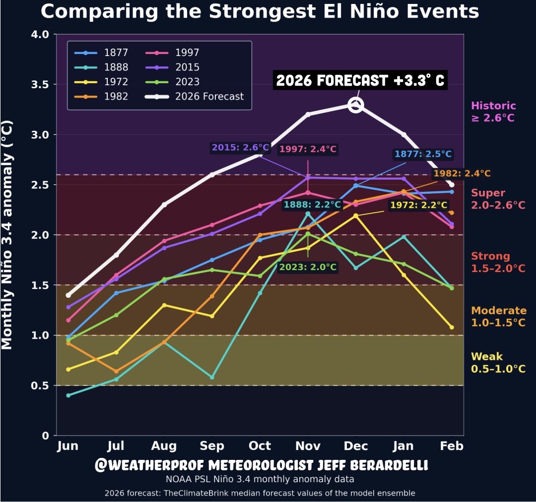
2026-2027 Strong/Super El Nino
forkyfork replied to Stormchaserchuck1's topic in Weather Forecasting and Discussion
what is this going to do to our climate baseline?
-
only thing growing on my lawn that is exposed to the sunlight is weeds - ground is dry as a bone here in central NJ and after the hot sunny temps this week the weeds will stop growing too....
-
A review of the hurricanes 1950 -2022
-
If that thick smoke that blots out the sky like in May 2023 had come right off the heels of the darkest, most cloudy spring/late winter, I'd be outta here.
-
Congrats to the 10 homes around the airport. MVY has done this before. The ASOS would’ve been interesting in the 60s and 70s. They pulled a 31° on 6/17 in 2003 which is pretty cool.
-
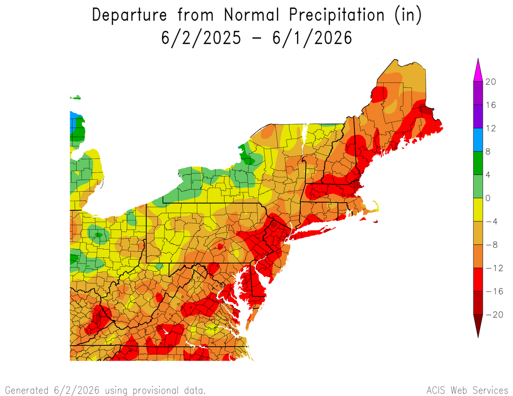
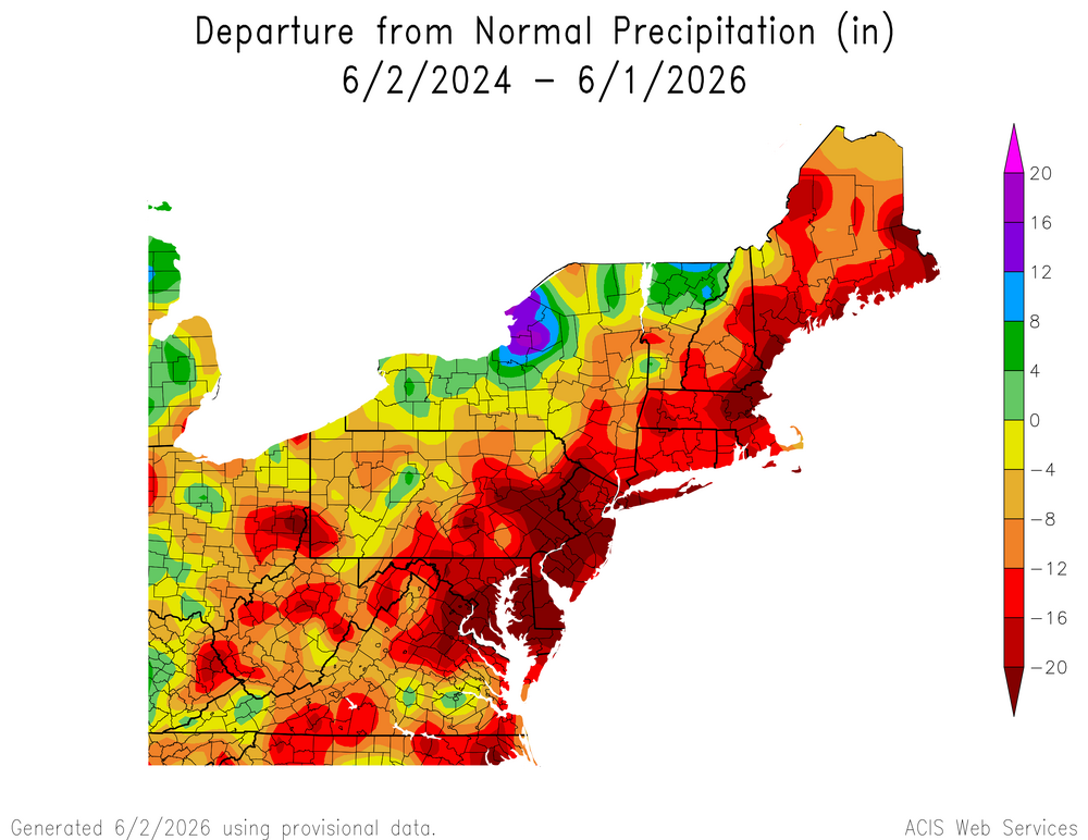
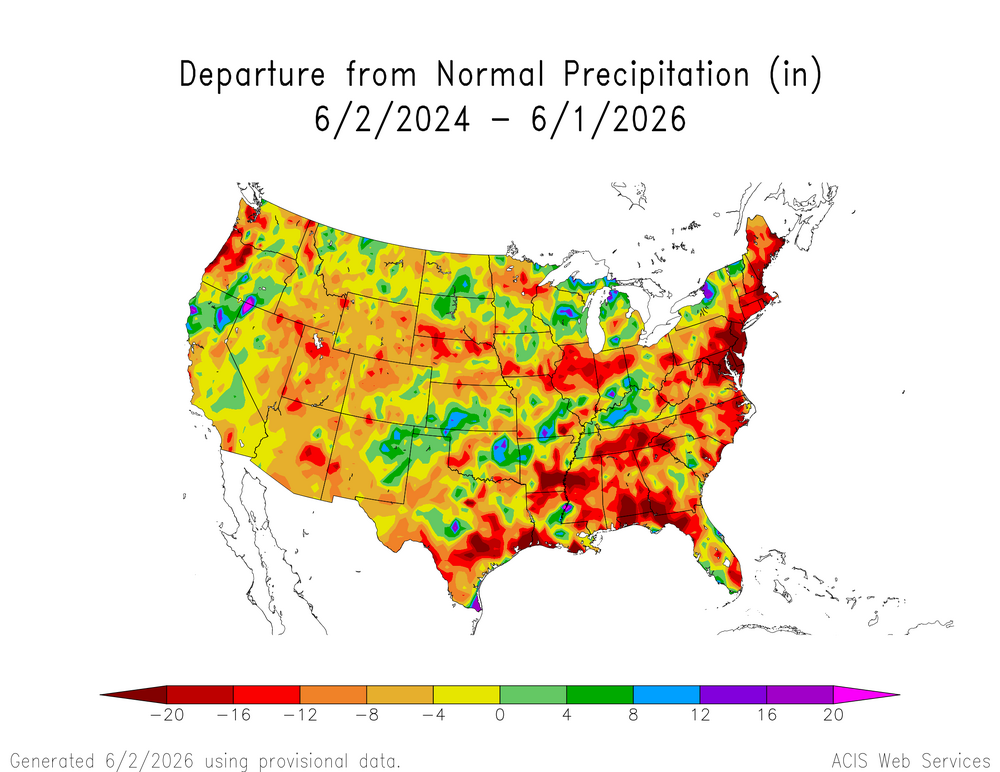
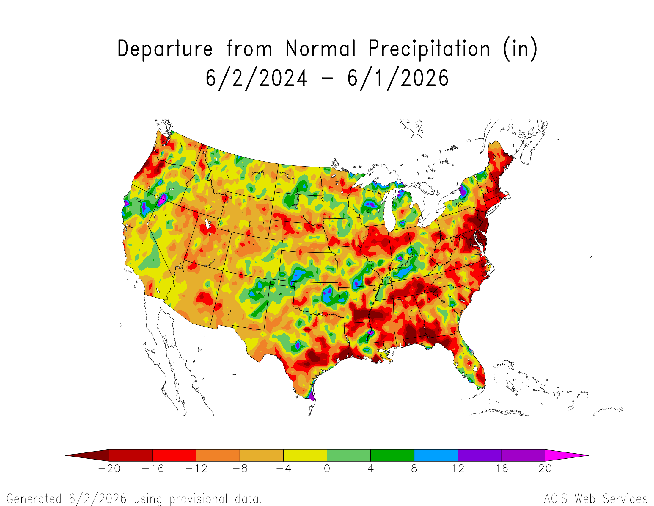
The last two years have been very dry across much of the CONUS. It will be interesting to see how things go with the developing super El Niño. The current pattern has been alternating between surges of Niña-like warmth and cooler El Niño-like intervals from the spring into early summer so far. But we have still been averaging out warmer than is typical this time of year for such a strong developing El Niño. So not sure if the precipitation will fully shift into a more Nino-like wet pattern or we still hold onto some reflection this Niña-like drought pattern. Ridges have been much stronger than usual across much of North America in recent years. So the more expansive high pressure has tended to really dry things out.
-
It's not the wet, it's the temps too.
-
Chilly morning at a few sties with 30's/lower 40's. Up in Cook county, temps down into the low-mid 30's.
-

2026-2027 Strong/Super El Nino
FPizz replied to Stormchaserchuck1's topic in Weather Forecasting and Discussion
Typical awfulness from the worst red tagger on the board -
83-88 is pretty much spot-on for mid-summer highs, that's what we will be seeing for many many days. Sure the dews will be hit-miss
-
We're winning so much we might even get tired of winning. Thank you for your attention...
-
2026-2027 Strong/Super El Nino
forkyfork replied to Stormchaserchuck1's topic in Weather Forecasting and Discussion
it made a bunch of weird losers mad. mission accomplished <3 -
WE will see-alot of these wet solutions have busted outside of Memorial day weekend disaster.
-
DLH Spring ranking Max avg 48.5 (tied 30th warmest out of 83 unique avg's) Min avg 28.8 (tied 37th warmest out of 78 unique avg's) Mean avg 38.7 (tied 29th warmest out of 73 unique avg's) Precip 6.25" (58th driest out of 146 unique amounts) Pretty mid range, so an average Spring within the record, and somewhat on the drier side.
-
2026-2027 Strong/Super El Nino
forkyfork replied to Stormchaserchuck1's topic in Weather Forecasting and Discussion
cope and cry
-
(002).thumb.png.6e3d9d46bca5fe41aab7a74871dd8af8.png)
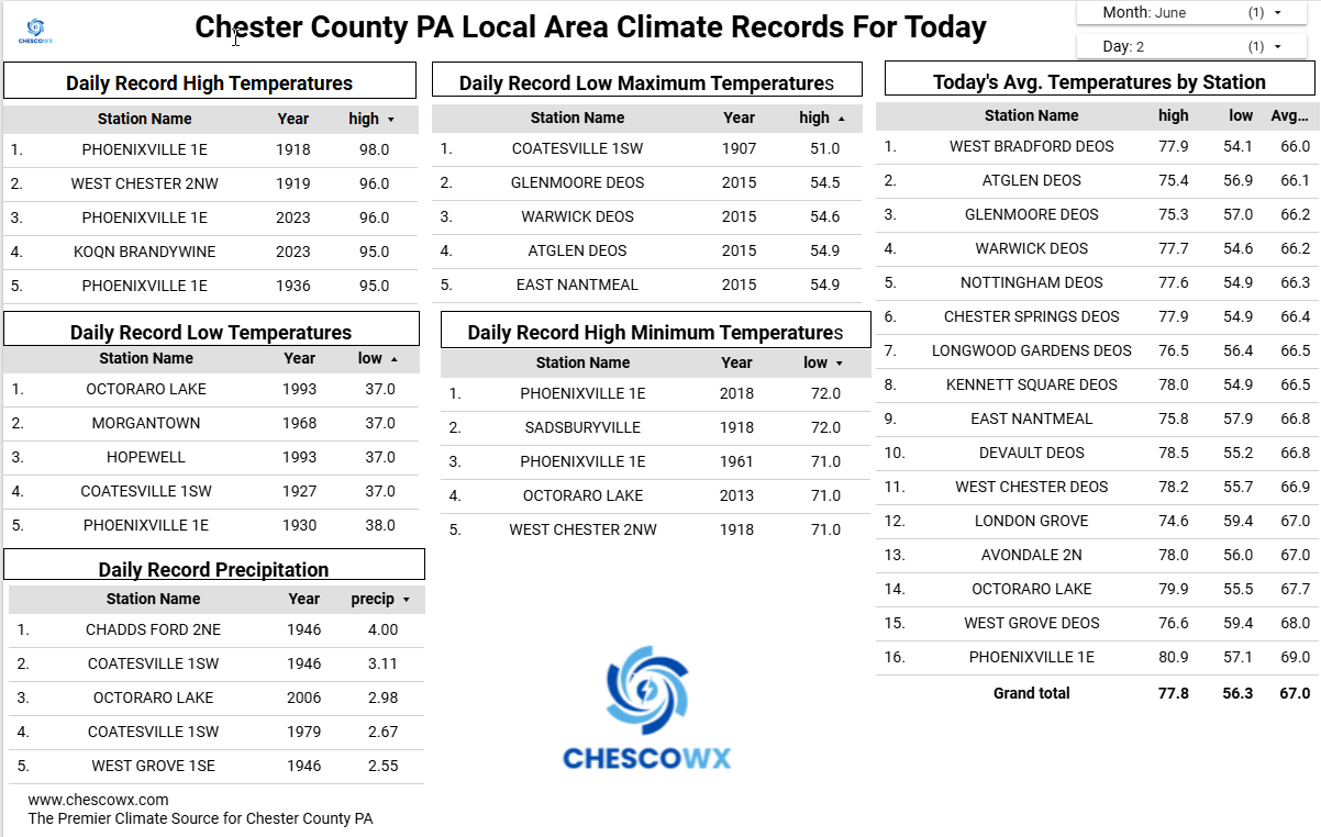
Central PA Summer 2026 Discussion/Obs Thread
ChescoWx replied to Voyager's topic in Upstate New York/Pennsylvania
Today will be the 11th of the last 13 days with below normal temperatures. Sunny and dry through Saturday. We should finally see some warmer than average temperatures by the end of the week and into the weekend. Rain chances look to increase by Sunday.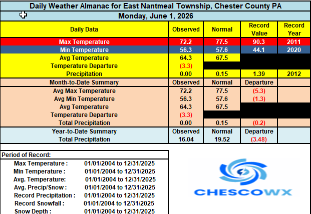
-
E PA/NJ/DE Spring 2026 Obs/Discussion
ChescoWx replied to PhiEaglesfan712's topic in Philadelphia Region
I am compiling the final averages but it looks like Chester County will finish around a 1 degree below the 1991-2020 average for the Month of May -
3 days in the 80s in June (others will get 4). Nothing obscene. Kinda boring. No thunderstorms, etc. for a bit
-

2026-2027 Strong/Super El Nino
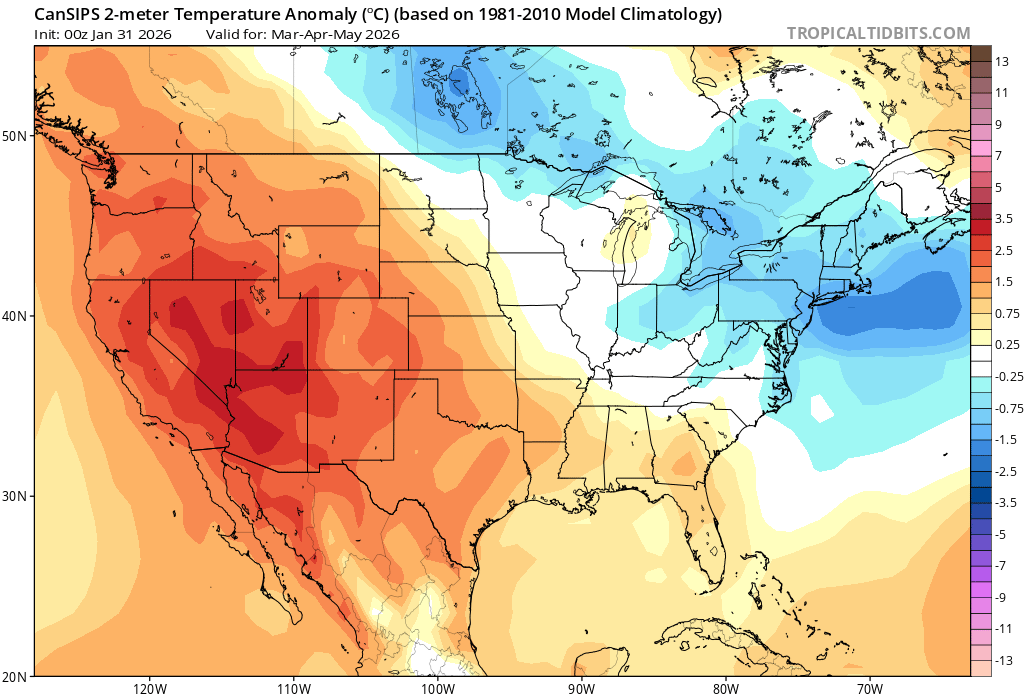
GaWx replied to Stormchaserchuck1's topic in Weather Forecasting and Discussion
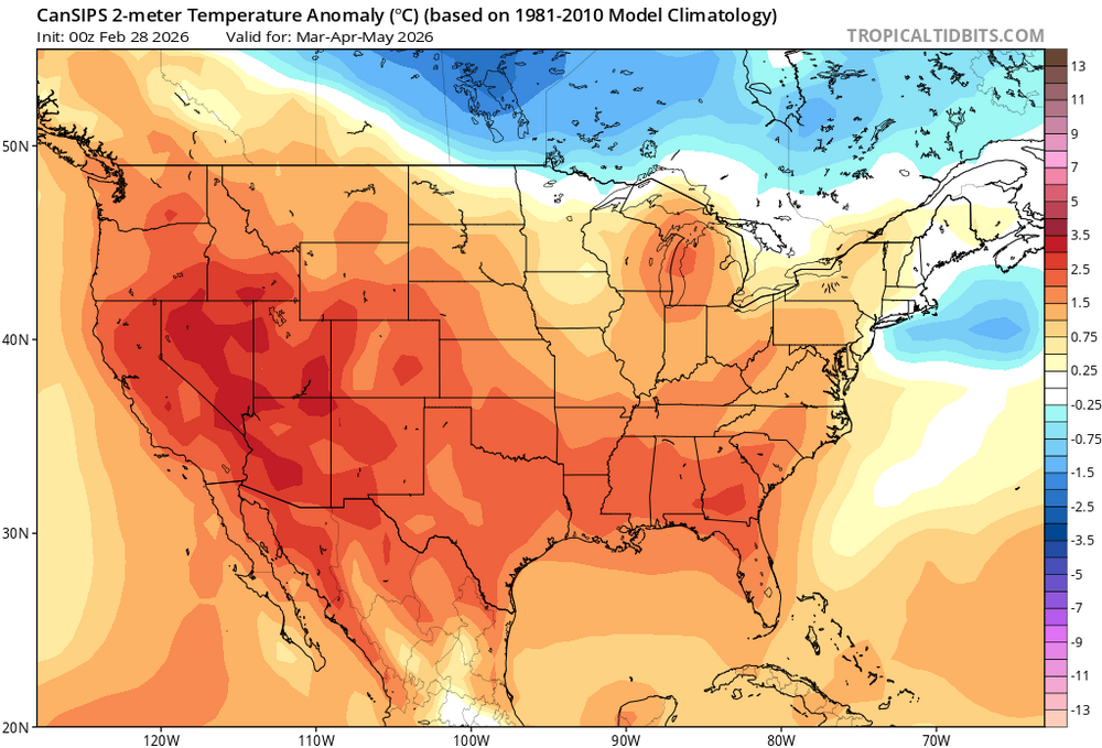
Thanks, Chris. Indeed, Cansips was much too cold in the E US this spring. And it has been too cold there at other times. But I’m curious. Does it actually have a well analyzed documented cold bias in the E US based on an amply sized sample based on a good number of years? I wouldn’t be surprised but it’s important to know, of course. -
I use MRCC cli-MATE data portal. Josh may use something else. https://mrcc.purdue.edu/
-
As for this ASOS stuff, I personally have issue with them anyway. I made this known when I first joined the forum a few years ago. There main function is for airport ops, not climate monitoring. Their placements generally suck. I have found some smaller airports where they placed them in decent spots. One that comes to mind is Ann Arbor, and Eau Claire seems decent. So, in the end, I've just given myself this advice. "Suck it up, shut up, and just enjoy the f**king the weather!" And if homogeny is such a stickler for some, well, you might just as well abandon the temp profiles of stations, and get a job at a milk plant. So, again, take my advice I've given myself; "Suck it up, shut up, and just enjoy the f**king the weather!"
- Today
-

2026-2027 Strong/Super El Nino
bluewave replied to Stormchaserchuck1's topic in Weather Forecasting and Discussion
The long range forecasts from the CanSIPS have a strong cold bias. Notice how the model had a cold spring especially in the Great Lakes and Northeast from the older forecasts. Didn’t really begin to catch on until the March 1st update. But even then it was too cold. Verification 2nd warmest spring on record for the CONUS Climatologist49 @climatologist49.bsky.social Follow Spring (Mar-May) temperature departure from the 1991-2020 normal. Seems warm. Climatologist49 @climatologist49.bsky.social · 20h Spring 2026 was the 2nd warmest on record for the Contiguous U.S. (2012). A majority of locations had a top 5 warmest spring compared to all springs since 1895 and many places had their warmest. Only a small area of the northern Plains had a cool spring compared to the full period-of-record. 2:07 PM · Jun 1, 2026 Everybody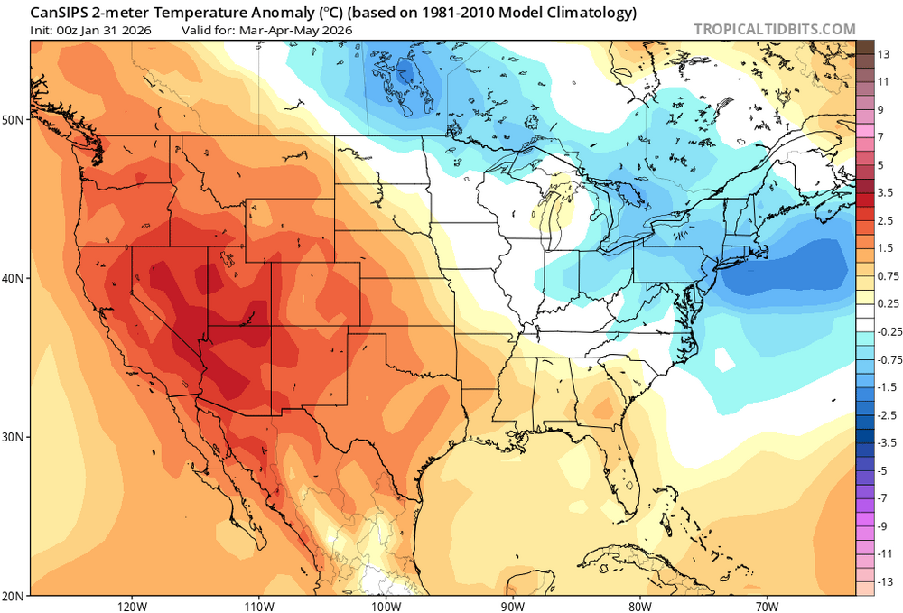
-

Central PA Summer 2026 Discussion/Obs Thread
pasnownut replied to Voyager's topic in Upstate New York/Pennsylvania
Facts always > feelings.... Hope yall are enjoying the beautiful stretch of early summer. Hard not to enjoy what the last few days have given us.


.thumb.gif.f92b16c631a1d15d405ed77b33f0710d.gif)