All Activity
- Past hour
-
Interesting. There have been large flocks hanging at the lake by my house for a few weeks now.
-

Spooky Season (October Disco Thread)
Typhoon Tip replied to Prismshine Productions's topic in New England
No it isn't; complete conspiracy -

The return of the elusive Nor'easter. Drought buster or bust?
hstorm replied to dailylurker's topic in Mid Atlantic
"Winter is over" bridge jumping on October 10 has to be a new forum record. Well done! -

Spooky Season (October Disco Thread)
ROOSTA replied to Prismshine Productions's topic in New England
I really miss the change of seasons. My nightmare will soon be over. I'm only going to get about 1/2 the going market price. SCREWED! A plan I've started to seriously consider is leaving everything possession wise, buying a RV and travel till end of days. -
the overnight low was 36. the house is a still a little chilly.
-
 can't trust the NAM past 60 hours but here is the total qpf most of which still falls past 60 hours
 -

"Potentially" powerful Nor'easter Sun-Mon 10/12-13/25 with needed rain-especially south of I84, and fairly high impact sct coastal gusts 50+ MPH and possibly moderate or greater coastal flooding at the midday Sun and Monday high tide cycles.
Stormlover74 replied to wdrag's topic in New York City Metro
Nam crushes all now. 6 to 8" ocean county along the coast -

The return of the elusive Nor'easter. Drought buster or bust?
WxUSAF replied to dailylurker's topic in Mid Atlantic
Well 12z meso runs are starting off positively FWIW (very little) -

E PA/NJ/DE Autumn 2025 Obs/Discussion
Chadzachadam replied to PhiEaglesfan712's topic in Philadelphia Region
The trend is my friend for Sunday! Looks like models are converging on the strung out euro solution. Euro AI and Ukie most consistently showed this and never really got on board with a full phase -

2025-2026 ENSO
40/70 Benchmark replied to 40/70 Benchmark's topic in Weather Forecasting and Discussion
100%. This is why I am so confident that my area will see more snowfall, even if it's a bit warmer. I do not feel warmth will be prohibitive for the vast majority of the season...at least not at this latiitude. -
The return of the elusive Nor'easter. Drought buster or bust?
WxUSAF replied to dailylurker's topic in Mid Atlantic
OMG I just LLLLOOVVVEEEEE Ninas! -
 Just looking but The eps ensembles at 6z had quite a west lean to them, closer to coast. Imo.
 -
2025-2026 ENSO
40/70 Benchmark replied to 40/70 Benchmark's topic in Weather Forecasting and Discussion
Direct Weather is as bad as any. -
2025-2026 ENSO
40/70 Benchmark replied to 40/70 Benchmark's topic in Weather Forecasting and Discussion
Yes, the issue was definitely increased stability...which may have been for a couple of reasons. -

The return of the elusive Nor'easter. Drought buster or bust?
dailylurker replied to dailylurker's topic in Mid Atlantic
When was the last time that happened? 2009? Same with clippers. Where did they go? -
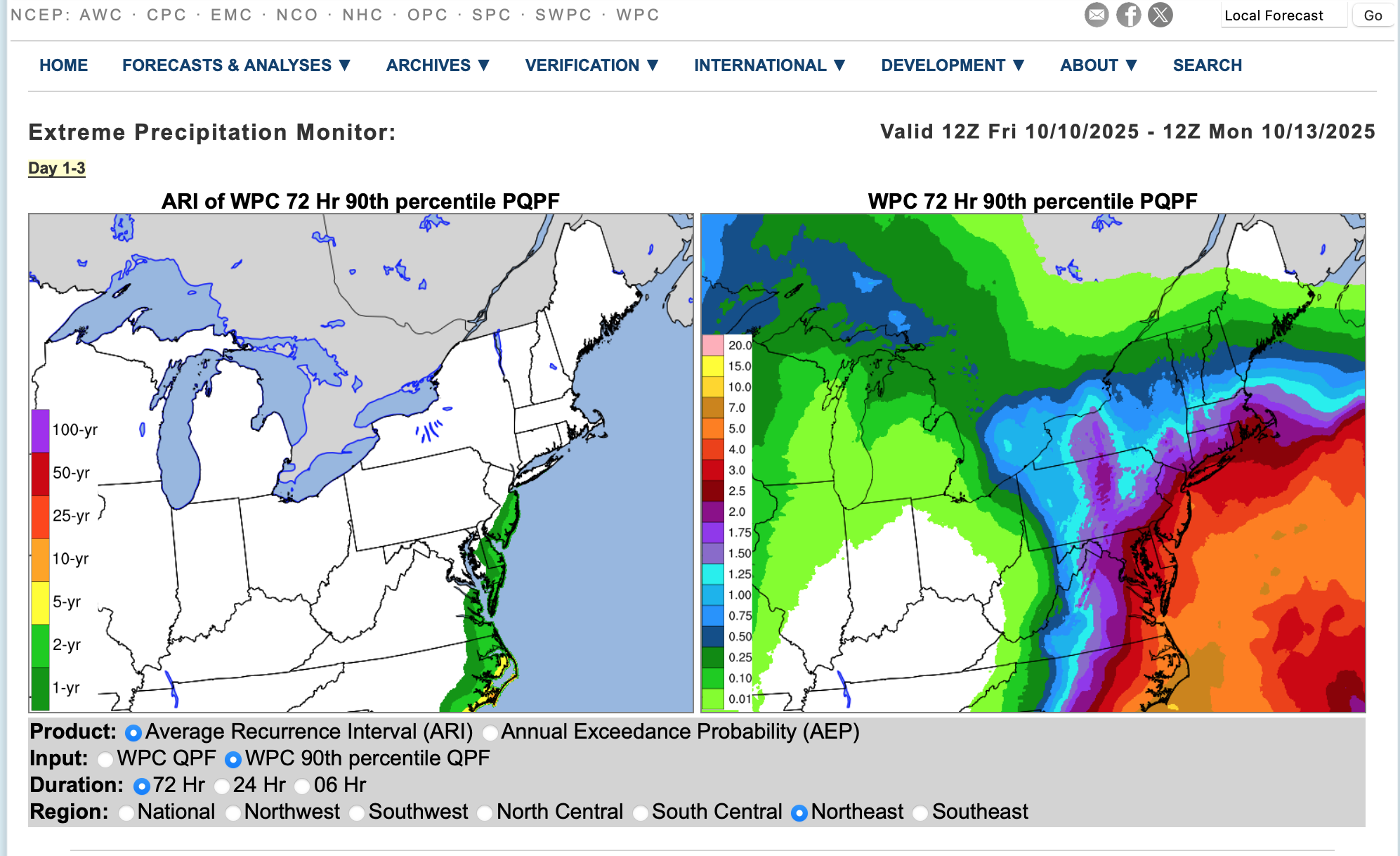
 fwiw: Average Return Interval on the 10z/10 WPC 72 hour FCST qpf... NJ coast every 1-2 years.
-
We had some good discussion last year during the mid season lull about the possibility that there’s a modest negative correlation between sunspots and Atlantic ACE. Sunspots were at a quite high level, especially in August of ‘24, when the tropics were dead. The hypothesis centers around the idea of slightly increased stability in the tropics during peak solar periods, enough to possibly make a difference sometimes. There’s been nothing proven though.
-

2025-2026 Fall/Winter Mountain Thread
ncjoaquin replied to Buckethead's topic in Southeastern States
41 on the dot here in the Hominy Valley. -

The return of the elusive Nor'easter. Drought buster or bust?
Eskimo Joe replied to dailylurker's topic in Mid Atlantic
Yup. Just give me a nice clean storm juiced up on gulf and Pacific moisture that has a clean hand off over Kentucky to a coastal low. 90% of the time it's a win. -
2025-2026 ENSO
40/70 Benchmark replied to 40/70 Benchmark's topic in Weather Forecasting and Discussion
I think it's the same issue that plagued my seasonal forecasting during the 2023-2024 El Nino season...folks need to reevaluate more archaic methods of forecasting given the rate at which the modern climate is changing. I don't think forecasters take into account the redued gradient between the sub tropics and the tropics enough, which stifles convective instability. We are warming more rapidly with latitude.....just like nights are warming more rapidly than days. The general warming of the oceans outiside of ENSO also alters the equations, which is something that I failed to appreciate. Remeber...weather happens because of the gradients that result from the redistribution of heat....nothing else. Alter that gradient and conventional forecasting methods will not work. -
I’m at 65 meters on this hill, makes sense
-
Spooky Season (October Disco Thread)
40/70 Benchmark replied to Prismshine Productions's topic in New England
Don't accept next time Scooter invites you over for nude holiday twister. -
"Potentially" powerful Nor'easter Sun-Mon 10/12-13/25 with needed rain-especially south of I84, and fairly high impact sct coastal gusts 50+ MPH and possibly moderate or greater coastal flooding at the midday Sun and Monday high tide cycles.
Stormlover74 replied to wdrag's topic in New York City Metro
Just a joke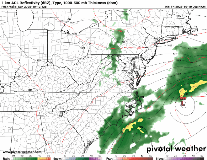
-
Spooky Season (October Disco Thread)
40/70 Benchmark replied to Prismshine Productions's topic in New England
The loss of "fake cold" is how the majority of CC manifests...and we know how very real that phenomenon is. -
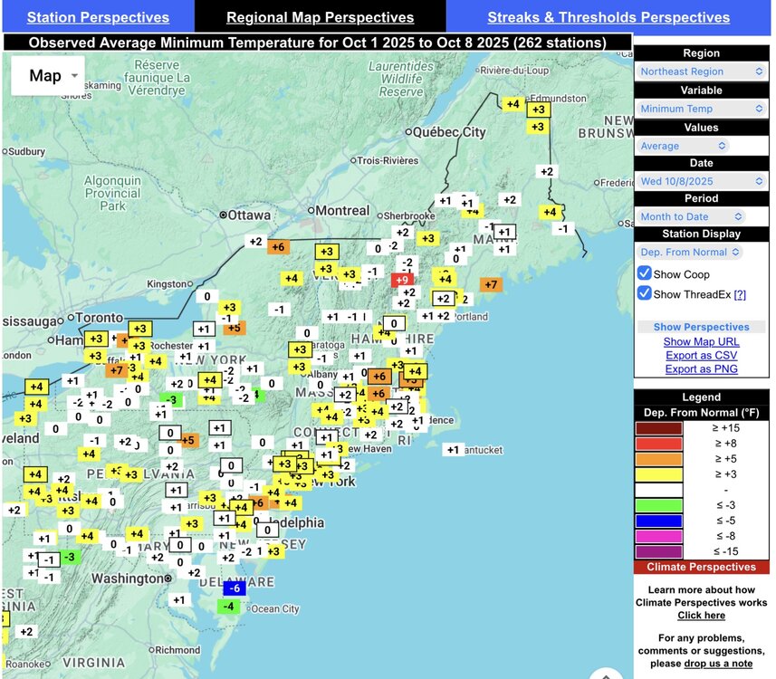
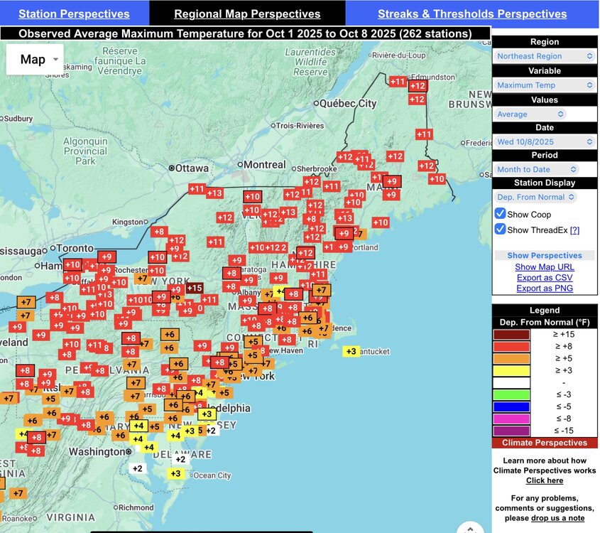
Pretty much the greatest divergence between the max and min departures for the first week of October that you will see. Saranac Lake may be the best example of this big spread. Record temperature rises and falls for early October within a few days. They were at a +9.4° max and a -2.9° min through yesterday. Climatological Data for Saranac Lake Area, NY (ThreadEx) - October 2025 Click column heading to sort ascending, click again to sort descending. Sum 617 293 - - 127 0 1.11 Average 68.6 32.6 50.6 3.2 - - - Normal 59.2 35.5 47.4 - 159 0 1.14 2025-10-01 59 26 42.5 -6.4 22 0 0.00 2025-10-02 64 23 43.5 -5.0 21 0 0.00 2025-10-03 72 29 50.5 2.4 14 0 0.00 2025-10-04 77 38 57.5 9.8 7 0 0.00 2025-10-05 82 42 62.0 14.6 3 0 0.00 2025-10-06 80 36 58.0 11.0 7 0 0.00 2025-10-07 75 42 58.5 11.9 6 0 1.08 2025-10-08 59 34 46.5 0.3 18 0 0.03 2025-10-09 49 23 36.0 -9.9 29 0 0.00 2025-10-10 M M M M M M M 2025-10-11 M M M M M M M 2025-10-12 M M M M M M M 2025-10-13 M M M M M M M 2025-10-14 M M M M M M M 2025-10-15 M M M M M M M 2025-10-16 M M M M M M M 2025-10-17 M M M M M M M 2025-10-18 M M M M M M M 2025-10-19 M M M M M M M 2025-10-20 M M M M M M M 2025-10-21 M M M M M M M 2025-10-22 M M M M M M M 2025-10-23 M M M M M M M 2025-10-24 M M M M M M M 2025-10-25 M M M M M M M 2025-10-26 M M M M M M M 2025-10-27 M M M M M M M 2025-10-28 M M M M M M M 2025-10-29 M M M M M M M 2025-10-30 M M M M M M M 2025-10-31 M M M M M M M