All Activity
- Past hour
-
I’m so tuned out. Really? A lot?
-
Looks like a snowy week up here on most modeling. Just when my shoulder was starting to heal.
-
I just find this so wild
-
.thumb.jpg.6a4895b2a43f87359e4e7d04a6fa0d14.jpg)
Central PA Spring 2026 Discussion/Obs Thread
Yardstickgozinya replied to Voyager's topic in Upstate New York/Pennsylvania
Nws take on today's severe weather threat. Unfortunately, hail along with a damaging wind threat seems to be the main threat today, for those of us near and in the corridor of slight risk according to the nws Area Forecast Discussion National Weather Service State College PA 502 AM EDT Sat Mar 21 2026 .WHAT HAS CHANGED... Dense Fog Advisory for a portion of east-central PA until 8AM Severe thunderstorm risk level increased from 1 to 2 for Sunday over south central PA && .KEY MESSAGES... 1) Low visibility in dense fog could make driving hazardous early this morning across portions of east-central PA 2) First weekend of Spring warmup precedes rain and severe thunderstorm risk Sunday afternoon into Sunday night && .DISCUSSION... KEY MESSAGE 1: Low visibility in dense fog could make driving hazardous early this morning across portions of east-central PA Temporary clearing in the wake of yesterdays rainfall has resulted in patchy to locally dense fog formation across portions of east central PA. Visibility trends have been improving on the margin upon the arrival of lower cloud deck continuing to expand southeastward per IR satellite imagery. Coordinated with PHI on issuance of DFA until 8AM with several ASOS and RWIS sites reporting visby below 1000ft or <1/4 mile. KEY MESSAGE 2: First weekend of Spring warmup precedes rain and severe thunderstorm risk Sunday afternoon into Sunday night A nice start to Spring this weekend with fcst highs ramping 15 to 30F above the historical average by Sunday. This surge of warmth will be brief and followed by a noticeable cooldown on Monday with max temps 20-30 degrees lower than Sunday. SPC expanded the level 2/slight risk outlook from the Upper Ohio Valley into south central PA (south of I-80) for Sunday afternoon and evening. CAPE and 0-6km shear profiles appear rather favorable for organized severe storms ahead of a southeastward advancing cold front. Large hail probs are relatively high with 700-500mb lapse rates 7-7.5 C/km and essentially match the damaging wind probs. -
Central PA Spring 2026 Discussion/Obs Thread
Yardstickgozinya replied to Voyager's topic in Upstate New York/Pennsylvania
@Jns2183 are you aware of anything I can use to open these files on my cellphone ?
- Today
-
Congrats on the crumbs
-
Quietly hitting 82 in DC Sunday
-
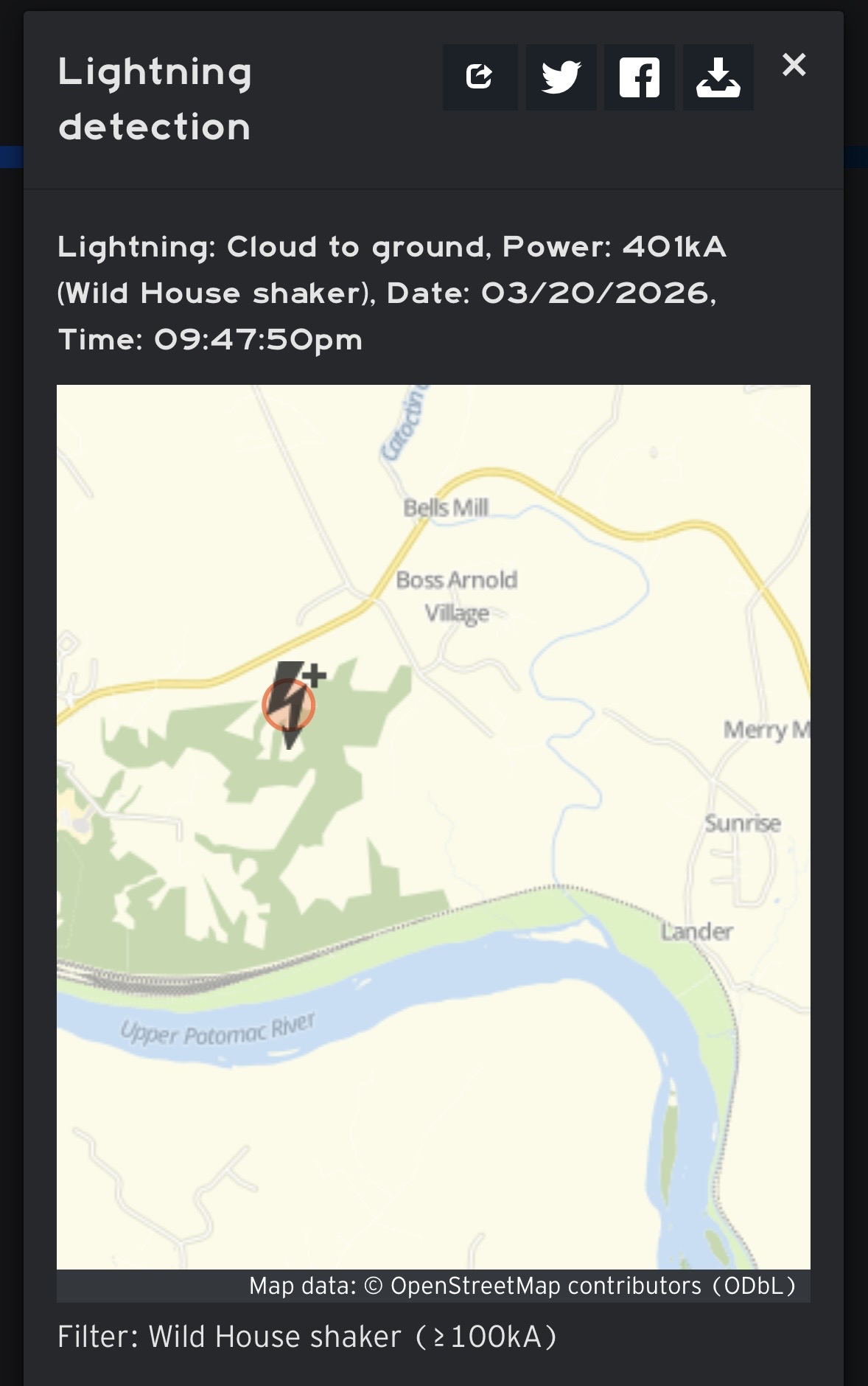
Looks like weather.us …also, wouldn’t this be up there with some of the most powerful strikes ever recorded? At least around here? Average is like 30kA right? I did NOT think there were any unique atmospheric variables at play last night.
-
Wow what a night (unexpected!) I shall dub the mystery bolt as the “Brunswick Boomer!” Both my weather stations with lightning detection picked it up, somehow with fairly accurate distances too (10mi from my Middleburg station near goose creek, 16mi from my Catharpin station towards Manassas.) Then I was woken up again to lots of lightning and thunder as the training storms eventually aligned with me, and I got that impressive cell for a good 10 minutes (peaked out at just under 1”/hr .3 total, nothing too wild. These were some pretty impactful storms, especially the training action. There wasn’t so much as a single peep about any of this in the forecast discussion from LWX, just the showers earlier with the fropa around the evening commute. What an exactly happened from a meteorological perspective? Aren’t things usually pretty dry and stable hours after a front has passed?
-
It is a rare occurrence to see a severe hail only event in East TN.
-
I miss snow. Spring sucks.
-
Central PA Spring 2026 Discussion/Obs Thread
Yardstickgozinya replied to Voyager's topic in Upstate New York/Pennsylvania
Slight risk extended well into Central Pa. There's no written mention in their outlook about what they expect in our area. Nws did update their discussion at 1:45am, but that discussion still said that the Spc was painting a marginal risk ,1 out of 5 through most of central Pa. However, you can clearly see that Spc expanded the slighg risk into cpa in there 1:01am update, so I decided not to post the latest nws forecast discussion. https://www.spc.noaa.gov/products/outlook/day2otlk.html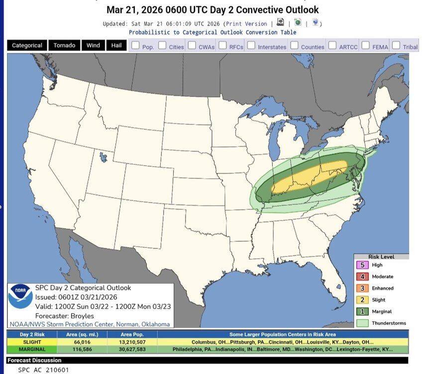
-
-Phoenix has set new (or tied) daily records highs 28 times during the last 365 days. -94 of the 366 days have record highs there set in 2023-6 due mainly to CC but with UHI also being a factor although UHI is normally more of a factor for warm lows. -There are a mere 3 record lows set since 1980!
-

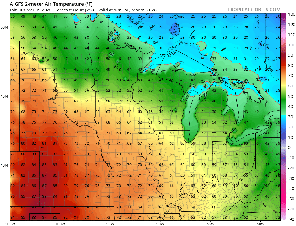
2026-2027 El Nino
cmillzz replied to Stormchaserchuck1's topic in Weather Forecasting and Discussion
AI GFS did a damn good job here with these temps as the high was indeed in the lower 60s for Chicago on the 19th with 70s in Iowa and 50s in Detroit, very impressive given the lead time. And of course, the cold shot ended up being confined to just the 18th, unsurprisingly.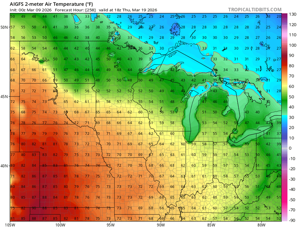
-
What app did you use to get this information? I would love to be able to look this kind of stuff up.
-

Central PA Spring 2026 Discussion/Obs Thread
Itstrainingtime replied to Voyager's topic in Upstate New York/Pennsylvania
Finished Friday with .36" of rain -
I am up in Altoona for the weekend and saw the Special Weather Statement come in for that one. Looking at radar looks like my house got the east side of it.
-

Occasional Thoughts on Climate Change
Stormchaserchuck1 replied to donsutherland1's topic in Climate Change
Flagstaff is the biggest crushing records in the area. Sedona, AZ is nearly 5000' and look at their forecast! 7-Day Forecast 34.87N 111.77W -
thunder and lighting for the last 30 minutes with more to come.
-
Looks like maybe up to an inch in a few spots Monday AM....back to check-out.
-
Heavy heavy freezing fog. Yikes.
-
Not expected to get out of the 40s here tmrw.
-
Bright lightning and thunder
-
GWDTLT
-
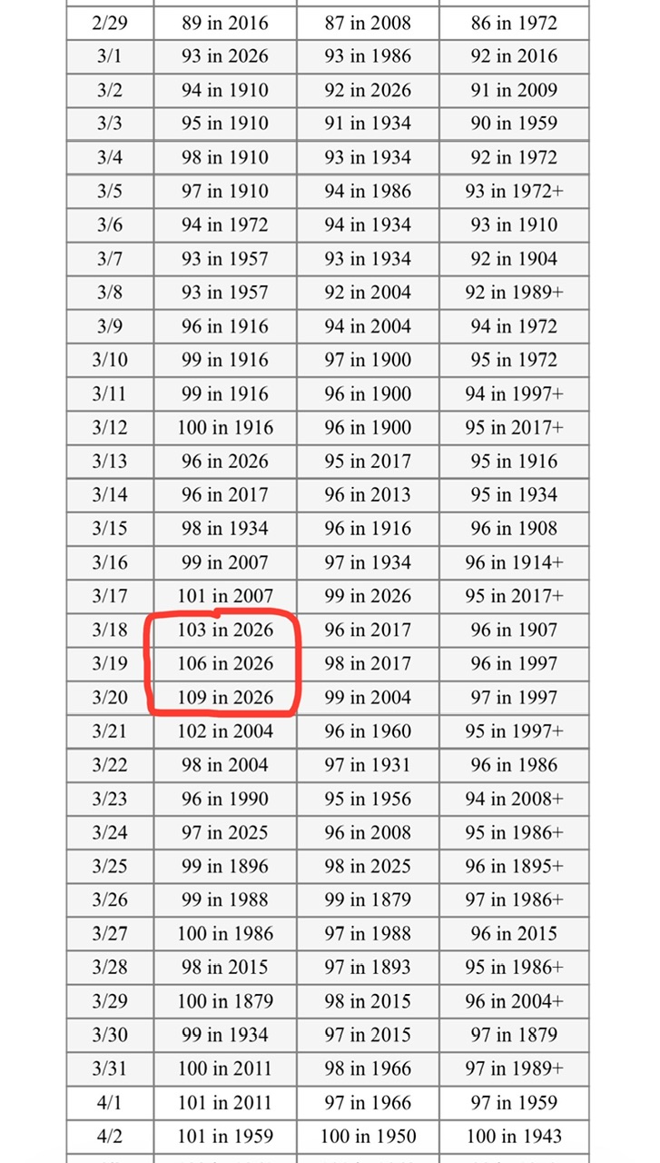
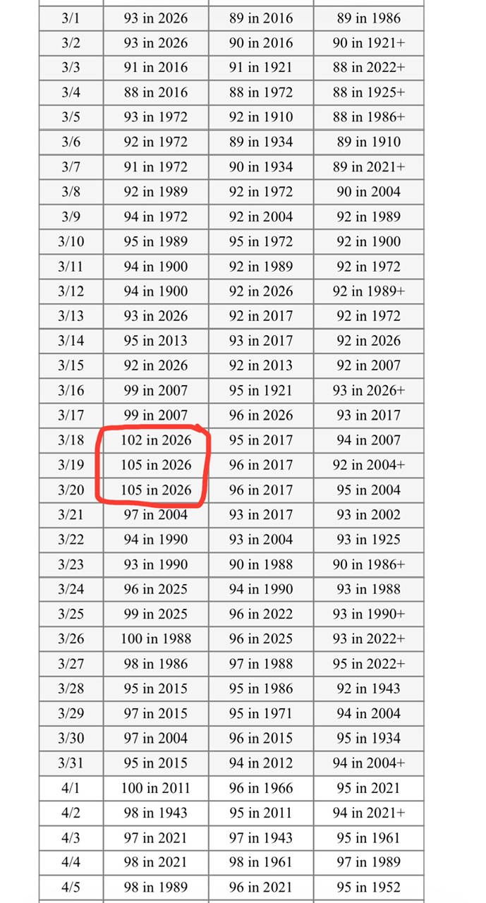
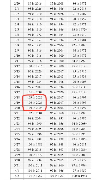
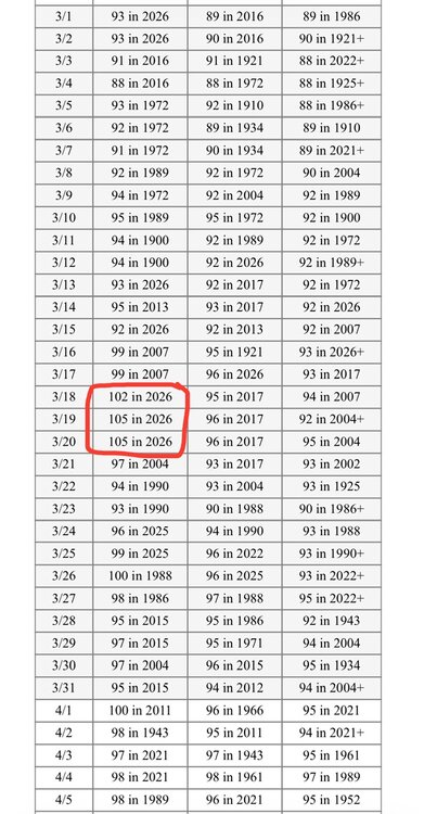
Yuma’s hottest on record in March prior to 2026 was 102. Yesterday was 106 and today was 109!! The earliest 109+ prior to today was May 2nd (1947) when it hit 111!!