All Activity
- Past hour
-
The 2020s has produced unprecedented summer warmth for both locations. Flagstaff and Phoenix both had their warmest summers on record in 2024 by a significant margin. All the 2020s summers have been in the top 10 for warmth which has never happened before. Time Series Summary for Flagstaff Area, AZ (ThreadEx) 10 Warmest Summers dense rank sorting by temperature Click column heading to sort ascending, click again to sort descending. 1 2024 68.4 0 2 1981 66.6 0 3 2002 66.3 0 4 2025 66.2 13 5 2021 66.1 0 6 2020 65.8 0 - 2007 65.8 0 - 1974 65.8 0 - 1940 65.8 0 7 2018 65.6 0 8 2022 65.4 0 - 2008 65.4 0 - 1980 65.4 0 9 2012 65.3 0 - 1946 65.3 0 10 2023 65.2 0 - 2017 65.2 0 - 1996 65.2 0 - 1977 65.2 0 Time Series Summary for Phoenix Area, AZ (ThreadEx)10 Warmest Summers dense rank sorting by temperature Click column heading to sort ascending, click again to sort descending. 1 2024 98.9 0 2 2023 97.0 0 3 2025 96.7 13 - 2020 96.7 0 4 2015 95.1 0 - 2013 95.1 0 5 2019 94.9 0 - 2007 94.9 0 6 2011 94.8 0 - 2002 94.8 0 - 1981 94.8 0 7 2022 94.7 0 8 2017 94.6 0 - 2016 94.6 0 - 2003 94.6 0 9 2006 94.5 0 10 1989 94.4 0 - 1988 94.4 0
-

Hurricane Erin: 105 MPH - 958 mb - NNW @ 10
NorthHillsWx replied to BarryStantonGBP's topic in Tropical Headquarters
I think it’s earlier collapse was much more drastic than anyone expected but given improving shear and very high ocean temps over its path the next few days I believe it recovers back to a healthy 2. I am convinced it weakened to a 1 this morning so I’d consider reaching its operational intensity as restrengthening lol -

Spring 2025 Med/Long Range Discussion
KakashiHatake2000 replied to John1122's topic in Tennessee Valley
oh i see gotcha i guess it has to do with new research or climate change or global warming or something but interesting nonetheless thank you daniel boone -
 A dramatic change to a sustained period of cooler weather has now occurred. High temperatures will likely reach the middle and upper 70s through Thursday and then the lower 80s on Friday through the weekend. Some showers or periods of rain are possible Wednesday afternoon into Thursday. Most of the region will see less than 0.50" or rain, though widely scattered areas of heavier rainfall are possible. The Jersey shore could see heavier rain and a gusty wind. The extended range guidance continues to suggest that the closing week of August could feature below normal temperatures. Precipitation could be near normal. The synoptic pattern should limit direct tropical cyclone threats for the foreseeable future. Impacts from elevated tides, surf, rip currents, and some showers or periods of rain would be the most likely effects produced by Erin as it tracks well offshore between the U.S. East Coast and Bermuda. There will be higher-than-climatological risk of at least one period in September with highs in the upper 80s or perhaps 90s. Summers similar to the current one have had September highs of 90 or above about 10 percentage points above that for all other years. The ENSO Region 1+2 anomaly was +0.6°C and the Region 3.4 anomaly was -0.3°C for the week centered around August 13. For the past six weeks, the ENSO Region 1+2 anomaly has averaged +0.53°C and the ENSO Region 3.4 anomaly has averaged -0.20°C. Neutral ENSO conditions will likely continue into early autumn. The SOI was -17.72 today. The preliminary Arctic Oscillation (AO) was -0.771 today. Based on sensitivity analysis applied to the latest guidance, there is an implied 80% probability that New York City will have a cooler than normal August (1991-2020 normal). August will likely finish with a mean temperature near 74.8° (1.3° below normal). Supplemental Information: The projected mean would be 0.4° below the 1981-2010 normal monthly value.
 -
Yeah, they have got to the point they change the Local Averages every other Year or so anymore. The long term Averages(Climate Norms) used to be 30 Year Periods. I think technically that still exists. On back to the extended Outlook cool down. Forecast's are adjusting to Model Guidance and lowering Temps. If Data continues with the big cool down you'll see the Forecast's lower temps the closer we get .
-
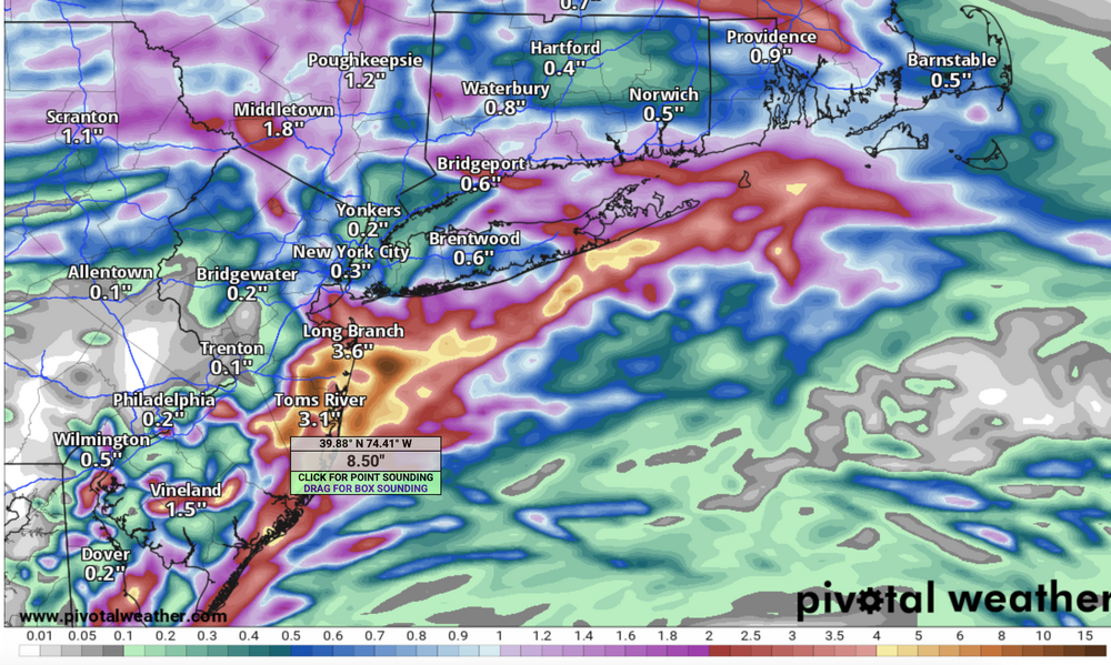
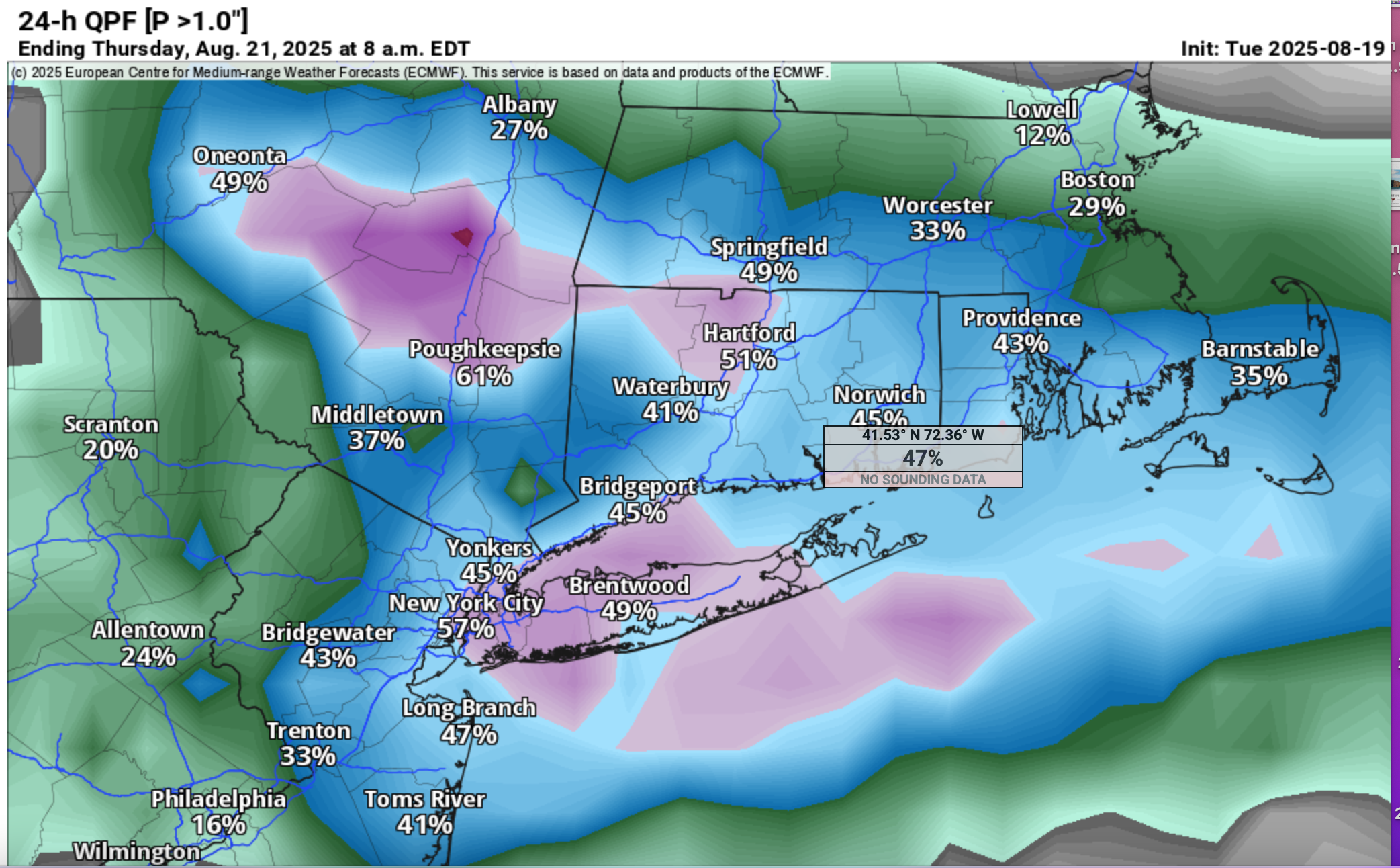
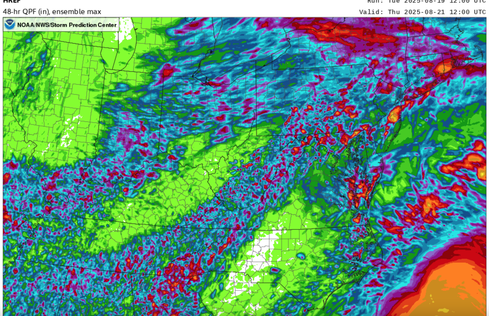
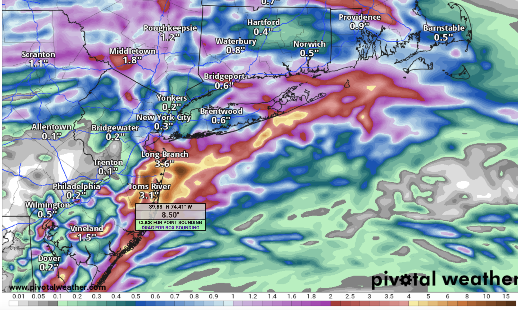
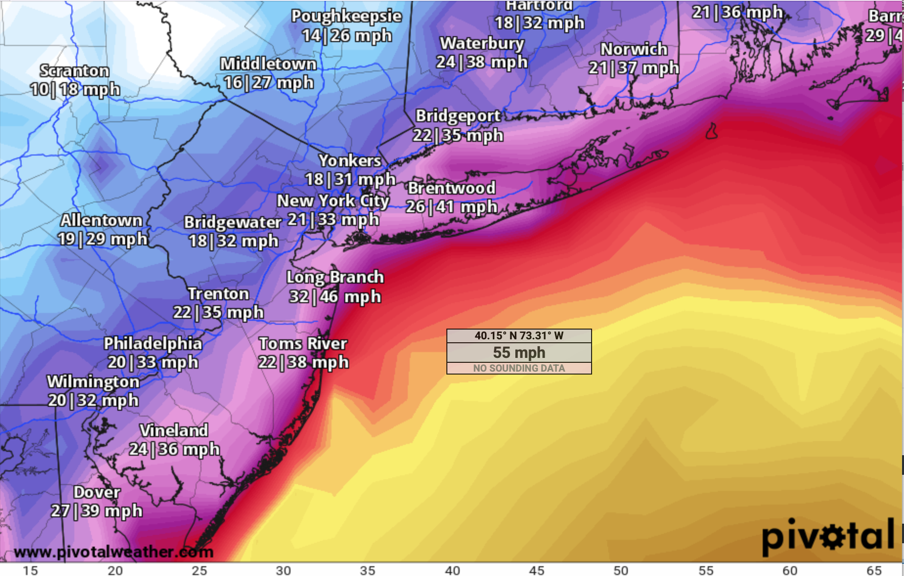
 Follow NWS-NHC. Will hold off thread due to uncertainty locating 5"+ bands but I think we're looking at some surprise heavy amounts (2-5") late Wed-early Thu but where. Will rereview this evening and again tomorrow morning for a more a confident expression of bands Erin indirect but I think related heavy rain. For now the ensembles are generalized-spread out. EC/EPS/ECAI have been onto this for quite a few cycles. Here's some graphics: EPS 12z/19 prob of 1"+ 24 hr amount by Thu AM. I think its within these magenta 50% prob that iso 5+ will occur. For now it's a marginal risk from WPC on FF rain. SPC HREF has iso 5-7"+ MAX POTENTIAL rain in the tan areas including coastal NJ 12z EC OP has been slipping swd with the max axis rainfall but it's very close to our area off of s LI to coastal NJ...see the graphic. Finally, how about the EPS Max 6hr G ending 2A Friday showing TS gusts in our ocean waters, even possibly grazing the NJ shore. This is as far northwest as I've seen on the EPS which creeps our way... follow NHC/NWS. All other modeling is seaward and not as threatening. Follow NHC assessment-thank you. So there 18z NAM12K/NAM 3K like GEFS-CMCE... I90 NYS-MA Not a confidence booster for locating near 5" axis as seen on the 18z NAM3K. No thread yet. Rechecking tonight and Wed AM. 432P/


-
The last time Phoenix had an August with average low temps below their long term mean was 1990. Flagstaff did it in 2017, 2016, and 2014. Along with a bunch of other years since 1990.
-
 it's congrats central New England this run....
 -

2025 Atlantic Hurricane Season
BarryStantonGBP replied to BarryStantonGBP's topic in Tropical Headquarters
Season cancel -
Kill em all.
-
All trendlines aside, in practical, very recent terms: - Phoenix was 3 degrees above their long term average in July 2025. Flagstaff was exactly average. - Phoenix was a ridiculous 9 degrees above their long term mean in July 2023. That same month, Flagstaff was about 5 degrees above theirs. - Phoenix hasn't had a June below their long term mean since 2009. Flagstaff's most recent was 2023. - Phoenix's hottest year on record was 2024. Flagstaff's was 1981.
-
I get that...what I don't understand is why aren't there big storms (of any kind, snow or rain) during the winter. With as much potential energy in the oceans as there is, you'd think the smallest perturbation would kick start a storm. Sure, we've seen some decent ones here and there, but nothing of note for nearly a decade. I am curious why given how much energy is available.
-
Occasional Thoughts on Climate Change
donsutherland1 replied to donsutherland1's topic in Climate Change
Yes, that’s correct. Phoenix has a pronounced UHI effect. One sees it particularly in the explosive increase in 90 or above low temperatures. -
a quote USTropics Professional-Met Posts: 2670 Joined: Sun Aug 12, 2007 3:45 am Location: Florida State University Re: Tropical Wave in the Central Atlantic (10/60) #239 by USTropics » Tue Aug 19, 2025 1:19 pm This is a solid assessment, at the end of the day this area just had too many competing vorticity maxima to consolidate. 50W longitude right now is kind of the magical line—if vorticity doesn't consolidate before then the low-level flow acceleration into the Caribbean really gets cranking and it's nearly impossible at that point (the Caribbean graveyard effect). A wave fracture is the most likely outcome now.
-
2025 Atlantic Hurricane Season
BarryStantonGBP replied to BarryStantonGBP's topic in Tropical Headquarters
-
 18z NAM fairly dry, though 3k NAM pretty wet.
 -
That's 30 years. And obviously the exact starting point matters...depending on if you start in 1970, 1980, 1995, 2005, 2010 you'll get differing trend numbers. But again, July/August is the primary monsoon season (rarely does it start until late June/early July, sometimes not until mid July). Including June makes about as much since if not less than including September. If I go as far back as the data allows (1933) and plot JJAS avg temp trend for Flagstaff, it's .3F/decade. For Phoenix, it's twice as much with .6F/decade. Same trend for JJA if you prefer that.
-
Yeah it's a beauty!
-
I'm pretty sure everyone in Maine has that capability.
-
I think they’re talking about snow storms specifically. The winter base state has gotten warmer meaning that we really need to thread the needle or else it’ll be too warm. psuhoffman can show you that overall snow in the region is trending downward.
-

Hurricane Erin: 105 MPH - 958 mb - NNW @ 10
GaWx replied to BarryStantonGBP's topic in Tropical Headquarters
This apparent restrengthening is as predicted by the Euro, UKMET, Icon and possibly others. -
Chris, Don and I have had discussions about the UHI portion of the warming at Phoenix over the last 30-40+ years due to the tremendous population growth. We agreed that the UHI portion isn’t at all insignificant if I’m recalling this correctly. @donsutherland1
-

Hurricane Erin: 105 MPH - 958 mb - NNW @ 10
eyewall replied to BarryStantonGBP's topic in Tropical Headquarters
Erin is definitely a lot healthier looking than earlier today. There may be an attempt at rebuilding the core now: https://tropic.ssec.wisc.edu/real-time/mimtc/2025_05L/web/displayGifsBy12hr_09.html -
@CoastalWx They’re coming https://www.wmtw.com/article/invasive-tick-that-can-reproduce-without-mating-found-in-maine/65818709
-

Hurricane Erin: 105 MPH - 958 mb - NNW @ 10
Wannabehippie replied to BarryStantonGBP's topic in Tropical Headquarters
Right now Erin is moving NNW, so the GFS model might not be picking up on that. No current flights in to Erin, but last flight, had a higher pressure that the last NHC report. https://www.tropicaltidbits.com/recon/recon_AF308-2005A-ERIN.png


.thumb.JPG.418e8a9a2902ae687ec35ff4bc0e038e.JPG)


