All Activity
- Past hour
-
And I bet you made alot more per hour than doing it for the city would
-

Feb 22nd/23rd "There's no way..." Obs Thread
Maestrobjwa replied to Maestrobjwa's topic in Mid Atlantic
Ahh I see. Welp, guess I'll have to accept my fate of being in the middle--but 6-8" still isn't bad. I'm guessing the NAM solution wasn't realistic? (Was that really a triple phase?) -

“Cory’s in NYC! Let’s HECS!” Feb. 22-24 Disco
OrangeCTWX replied to TheSnowman's topic in New England
Looks like most models have converged on 12-16 here. Potential for more sure, but that seems like the right forecast right now. Coastal NJ and SEMA seem like the jackpot spots. -
Feb 22nd/23rd "There's no way..." Obs Thread
Maestrobjwa replied to Maestrobjwa's topic in Mid Atlantic
Ahh I see. Welp, guess I'll have to accept my fate of being in the middle--but 6-8" still isn't bad. I'm guessing the NAM solution wasn't realistic? (Was that really a triple phase?) -
Was 87 in Miami today. Will be 65 on Monday. I come back Wednesday
-
It's really mesoscale time imo .
-

Central PA Winter 25/26 Discussion and Obs
pasnownut replied to MAG5035's topic in Upstate New York/Pennsylvania
This is why many of us are here, but yeah, we hang out w/ some good folks as well. Enjoy all. This is the good stuff (even if a little east for my liking). -
They’re crazy high, but this is a crazy strong storm (sub 975 mb) with a lowest at 500 mb of sub 520 and tons of moisture. I mean this is a once in 10+ years kind of deal with crazy heavy snowfall rates that can easily accumulate well even with temps up to 34-35.
-

“Cory’s in NYC! Let’s HECS!” Feb. 22-24 Disco
Henry's Weather replied to TheSnowman's topic in New England
For big dogs SNE-wide, I have learned over the years to want H5 centers to track closer to ACK. I don’t like, and haven’t really liked frankly, these H5 progressions right over BM. Not a met, but my 2 cents -
GEFS more robust than GFS
-
i forgot that one lol..
-
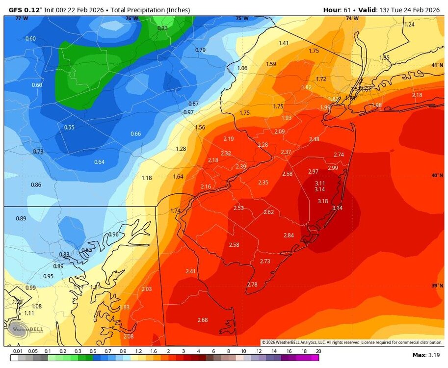
2/22 00z GEFS Total QPF 2/22-2/23-24 Mean Snow 10:1
-
From the Philly subforum
-

Blizzard of 2026 Storm Thread/OBS
PhiEaglesfan712 replied to Mikeymac5306's topic in Philadelphia Region
Last 2" - 5/13 to 5/16/2025 (3.11 inches over 4 days) 2025-05-13 71 62 66.5 3.1 0 2 0.28 0.0 0 2025-05-14 66 59 62.5 -1.2 2 0 1.30 0.0 0 2025-05-15 77 63 70.0 6.0 0 5 0.03 0.0 0 2025-05-16 77 60 68.5 4.2 0 4 1.50 0.0 0 Last 1 " - 1/25/2026 (our last snowstorm) 2026-01-25 24 15 19.5 -13.7 45 0 1.39 9.3 2 Before that was 12/19/2025 (our warmest day this winter) 2025-12-19 61 31 46.0 8.3 19 0 1.48 0.0 0 -
i was old enough to remember the days when joe bastardi did accuweather radio forecasts on 1010 wins along with dr joe sobel elliot abrams etc..
-

Feb 22nd/23rd "There's no way..." Obs Thread
nw baltimore wx replied to Maestrobjwa's topic in Mid Atlantic
Cool. Cheers! -
If the norlun is over Baltimore, we’ve got a much larger problem. Would likely mean the storm is way east offshore
-

“Cory’s in NYC! Let’s HECS!” Feb. 22-24 Disco
ORH_wxman replied to TheSnowman's topic in New England
Yeah it’s felt like a classic New England winter…which is really more typical of northern New England hill towns. But it’s nice when they happen down here too which we had been in a recent drought on them. -
gonna be tough to shovel this stuff
-
Feb 22nd/23rd "There's no way..." Obs Thread
nw baltimore wx replied to Maestrobjwa's topic in Mid Atlantic
It actually got better! Enjoy your whiskey! -
One of the reasons I hate taking trips in the winter is for fear of missing something with this potential. Yet I'm gone this March 3-10 in Florida. I've been checking the weather for those dates here for the past week.
-

Feb 22nd/23rd "There's no way..." Obs Thread
Terpeast replied to Maestrobjwa's topic in Mid Atlantic
I think there’s a limit to how far east it’ll go as the sfc low track is pretty much locked in +/- 30 miles, and most models have had the norlun from HGR - W loudoun - Fauquier though it shifted east by maybe 10-20 miles on 00z. I don’t think it’ll shift further east by more than 10-20 miles, and certainly not to bmore unless the storm actually changes track -
In the old days we had chief meteorologist Gordon Barnes and meteorologist Alan Kasper.
-
RGEM doesn't like the western edge at all. Either we get 6-10" or 20-30". No inbetween with this storm.
-
Font forget 2003


