All Activity
- Past hour
-
Up to 74 before it became mostly cloudy now some more breaks - Just a fab day
-
Glad I don't live there. Never mind it is headed this way
-
I have no idea what this means.
-

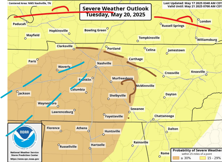
May 17th-20th severe weather discussion
Chinook replied to Chinook's topic in Central/Western States
The HRRR runs have several intense helicity tracks across the enhanced-moderate risk area. A little bit away from OKC and Wichita. 15% hatched tornado risk in the area of Wichita. -
none at nyc. Lowest 38 (1976) - 5-19 and 39 (1963) 524
-
At least most of the helicopters and Oak dongs blew down in wind today . Get that nightmare over with.
-
Tuesday it appears that the warm front will be up along the Ohio River again. Outflow should at least start out in Tennessee. System should be strong enough to lift it north again. However the timing is just a little faster than on Friday.. So we get other prefrontal convergence line(s) in Tennessee. That's not necessary a recipe for upgrade. As SPC notes it's a bit veered off. Shortwave could also outrun storms, which would really help keep things in check. Slower wave than what the globals show would tee up the Valley a bit.
-
Pattern looks good after this week
-
What will you do to enjoy the cool?
-
It has happened, but only naturally in Tuckerman Ravine. I’ve never heard of it happening at a ski area with manmade snow (although I’m sure they could pull it off it they wanted to by simply making enough snow and using blanketing techniques, etc.) It looks like the last time it happened was 1926, and that appeared to be unusual, but it may have happened more in the preceding century. Regarding the snow in Tuckerman Ravine from the link below: “It lasts longer here than in any other area in the eastern United States. During recent years it has disappeared, on the average, during the first week in August, but it persisted through the summer of 1926, “for the first time in the memory of the old timers” and new snow fell on the old in October.” I think it’s much more about the spring/summer temperature, humidity and precipitation regime and how soon temperatures cool down in the autumn vs. total snowfall for the previous season. And for Tuckerman Ravine, I bet the season’s avalanche patterns would have an effect as well. https://www.cambridge.org/core/journals/journal-of-glaciology/article/an-historical-survey-of-the-lateseason-snowbed-in-tuckerman-ravine-mount-washington-usa/9A5964D0AA6C9D6E9D5A2C55493F4F1C
-
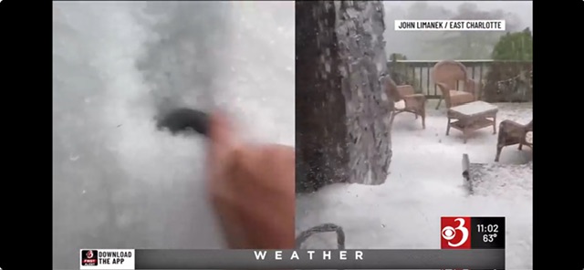
This was in Charlotte. It was on WCAX last night. https://www.wcax.com/2025/05/18/high-water-hail-storms-hit-region/
-
Same here...
-
Great 45 day 5H look back in early April by the EPS nailed this upcoming week.
-
I did not install and looks like it won’t happen for awhile.
- Today
-
Hmm a fan and a pool night's are 50s who needs AC for that 3 hr period it was 80.
-
Some of the people here should pool their money together in order to purchase some land in the Floribama area...and then open a commune.... "Triple H Commune- Built To Remind You of Tolland And Billerica But With The Stench Of The Deep South"
-
And that's a scary thought.
-

-
This is the warm day of the week.
-
Nah. 70s. But yeah, it’s shat. Get it out of the way now rather than JJA. I don’t want another summer 2009.
-
Not looking likely. Continues to look like the Arctic/PNA domains are going to play a heavy influence at least into the first week of June. Maybe not so much the NAO or AO but I would have think some of the daily PNA values have to be nearing top 5 for the upcoming period. Going to be tough to get a really hot summer here, if for any reason we don't even look to be building any sustained or early heat in the southwest. There's been fluxes of some big early season heat in the Southwest into Texas but not sustaining.
-
This pattern needs to change
-
Close to 1300 w/m^2 solar radiation today statewide. Solar panels are probably cooking good.
-
doesn't feel like it with thick overcast and a stiff breeze.
-
do you have a list of lowest lows, how many lower than 35 after May 19th?


