All Activity
- Past hour
-

July 2025 Obs/Disco ... possible historic month for heat
Ginx snewx replied to Typhoon Tip's topic in New England
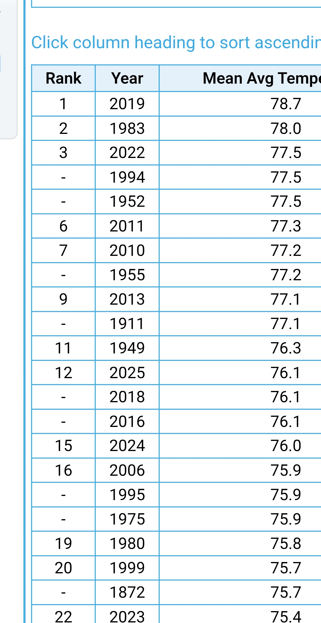
Average lows didn't crack top ten lowest in SNE except HFD area was number 9. Lots of hype -
Latest on flood watch from NWS. District of Columbia-Frederick MD-Carroll-Northern Baltimore- Cecil-Southern Baltimore-Prince Georges-Anne Arundel-Charles-St. Marys-Calvert-Northwest Montgomery-Central and Southeast Montgomery-Northwest Howard-Central and Southeast Howard- Northwest Harford-Southeast Harford-Fairfax-Arlington/Falls Church/Alexandria-Northern Fauquier-Southern Fauquier-Western Loudoun-Eastern Loudoun-Northwest Prince William-Central and Southeast Prince William/Manassas/Manassas Park- 1035 AM EDT Thu Jul 31 2025 ...FLOOD WATCH REMAINS IN EFFECT FROM 2 PM EDT THIS AFTERNOON THROUGH LATE TONIGHT... * WHAT...Flash flooding caused by excessive rainfall continues to be possible. * WHERE...The District of Columbia, portions of Maryland, including the following areas, Anne Arundel, Calvert, Carroll, Cecil, Central and Southeast Howard, Central and Southeast Montgomery, Charles, Frederick MD, Northern Baltimore, Northwest Harford, Northwest Howard, Northwest Montgomery, Prince Georges, Southeast Harford, Southern Baltimore and St. Marys, and northern Virginia, including the following areas, Arlington/Falls Church/Alexandria, Central and Southeast Prince William/Manassas/Manassas Park, Eastern Loudoun, Fairfax, Northern Fauquier, Northwest Prince William, Southern Fauquier and Western Loudoun. * WHEN...From 2 PM EDT this afternoon through late tonight. * IMPACTS...Excessive runoff may result in flooding of rivers, creeks, streams, and other low-lying and flood-prone locations. Flooding may occur in poor drainage and urban areas. Extensive street flooding and flooding of creeks and rivers are possible. * ADDITIONAL DETAILS... - Significant flash flooding is possible. Numerous showers and thunderstorms will develop and move across the area this afternoon into this evening. Thunderstorms will be capable of producing very heavy rain, with rainfall rates of 1 to 2 inches in 30 minutes. Widespread rainfall amounts of 1 to 2 inches are expected. Some areas could experience multiple rounds of thunderstorms, with higher rainfall amounts of 4 to 6 inches possible. This could result in numerous instances of flash flooding. Showers and thunderstorms will begin early this afternoon, and the heaviest rainfall is most likely from 3 PM to 8 PM. (my emphasis) - Please visit www.weather.gov/safety/flood for flood safety and preparedness information.
-

July 2025 Obs/Disco ... possible historic month for heat
TauntonBlizzard2013 replied to Typhoon Tip's topic in New England
Another missed rain event today. It’s so dry -

July 2025 Discussion-OBS - seasonable summer variability
donsutherland1 replied to wdrag's topic in New York City Metro
Here's a gift link so that anyone can read the article: https://wapo.st/4mdOi2m -
Storms are already rapidly developing east of the river currently. https://weather.cod.edu/satrad/nexrad/?parms=CCX-N0B-1-24-100-usa-rad
-
This makes you wonder what it feels like when places have hit rare super high dew points of 88 or 90.
-

July 2025 Obs/Disco ... possible historic month for heat
Modfan2 replied to Typhoon Tip's topic in New England
Looking like a I-84 NW rain event so far -
Another note - a lot has been said about flooding/rainfall totals (rightly so) but Elliott is really hyping severe weather this afternoon. He said that CAPE is as high as it ever gets in these parts and he fears that storms will pack winds of 60-70 mph. That concerns me.
-
July 2025 Obs/Disco ... possible historic month for heat
Ginx snewx replied to Typhoon Tip's topic in New England
Boston, Hartford, PVD, ORH Not even top ten hottest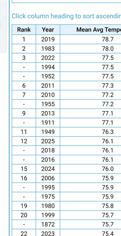
-
Haha, wunderground now has all of Cumberland county and Harrisburg city proper getting less than 0.10" of rain today Sent from my SM-G970U1 using Tapatalk
-
Saw my first baby furry caterpillar today, severe winter upcoming is a lock!!!
-
 Carteret put out a message that we could be in the bull’s-eye, could be 5 to 7 inches of rain, expect flooding, stay off the road, etc. I don’t want anyone to see that much water! At least they’re being more proactive than usual, because it’s damn near a guarantee we’re going to flood, it’s just a matter of how badly. I wish everyone good luck and safety.
 -
Stuffing popping up in northern Balt Co.
-

July 2025 Discussion-OBS - seasonable summer variability
SACRUS replied to wdrag's topic in New York City Metro
https://www.washingtonpost.com/weather/2025/07/31/record-humidity-july-maps/ -
I'm at 89 currently.
-
Latest NWS statement on flood watch District of Columbia-Frederick MD-Carroll-Northern Baltimore- Cecil-Southern Baltimore-Prince Georges-Anne Arundel-Charles-St. Marys-Calvert-Northwest Montgomery-Central and Southeast Montgomery-Northwest Howard-Central and Southeast Howard- Northwest Harford-Southeast Harford-Fairfax-Arlington/Falls Church/Alexandria-Northern Fauquier-Southern Fauquier-Western Loudoun-Eastern Loudoun-Northwest Prince William-Central and Southeast Prince William/Manassas/Manassas Park- 1035 AM EDT Thu Jul 31 2025 ...FLOOD WATCH REMAINS IN EFFECT FROM 2 PM EDT THIS AFTERNOON THROUGH LATE TONIGHT... * WHAT...Flash flooding caused by excessive rainfall continues to be possible. * WHERE...The District of Columbia, portions of Maryland, including the following areas, Anne Arundel, Calvert, Carroll, Cecil, Central and Southeast Howard, Central and Southeast Montgomery, Charles, Frederick MD, Northern Baltimore, Northwest Harford, Northwest Howard, Northwest Montgomery, Prince Georges, Southeast Harford, Southern Baltimore and St. Marys, and northern Virginia, including the following areas, Arlington/Falls Church/Alexandria, Central and Southeast Prince William/Manassas/Manassas Park, Eastern Loudoun, Fairfax, Northern Fauquier, Northwest Prince William, Southern Fauquier and Western Loudoun. * WHEN...From 2 PM EDT this afternoon through late tonight. * IMPACTS...Excessive runoff may result in flooding of rivers, creeks, streams, and other low-lying and flood-prone locations. Flooding may occur in poor drainage and urban areas. Extensive street flooding and flooding of creeks and rivers are possible. * ADDITIONAL DETAILS... - Significant flash flooding is possible. Numerous showers and thunderstorms will develop and move across the area this afternoon into this evening. Thunderstorms will be capable of producing very heavy rain, with rainfall rates of 1 to 2 inches in 30 minutes. Widespread rainfall amounts of 1 to 2 inches are expected. Some areas could experience multiple rounds of thunderstorms, with higher rainfall amounts of 4 to 6 inches possible. This could result in numerous instances of flash flooding. Showers and thunderstorms will begin early this afternoon, and the heaviest rainfall is most likely from 3 PM to 8 PM. - Please visit www.weather.gov/safety/flood for flood safety and preparedness information.
-
85/78 at DCA at 10am... yucky
-

July 2025 Discussion-OBS - seasonable summer variability
Sundog replied to wdrag's topic in New York City Metro
At least regarding the airborne pollutants, they were much worse in the past compared to today. -
could get a sneaky 90F today
-
Initiation near Bel Air
-
I'll happily take higher temperatures with lower dewpoints. Yesterday was horrendous and today my heat index was 96 with a 84 air temperature. Literally makes me nauseous Sent from my SM-G970U1 using Tapatalk
-

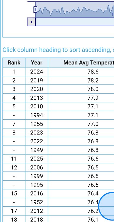
July 2025 Obs/Disco ... possible historic month for heat
TheClimateChanger replied to Typhoon Tip's topic in New England
Here's what PRISM has for nationwide lows. We have a very good shot at setting a national monthly record here. Current record is around +1.8F (relative to 1991-2020). -
 sunnier than expected as things have slowed down-already 85 in alot of places including here.
 -
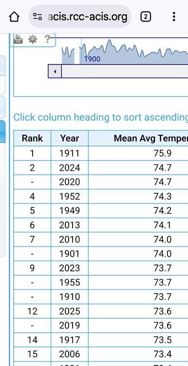
July 2025 Obs/Disco ... possible historic month for heat
TheClimateChanger replied to Typhoon Tip's topic in New England
I am having trouble loading NCEI's Climate at a Glance, seems to load better at the end of each day. But I think I did undersell this July a bit. Looking at the numbers, I think a lot of statewide means will come in significantly higher than shown by the urban stations. Rural and high elevation sites looked to be the most above normal, which aren't really reflected in the numbers. I didn't look at New England, but I think a Top 5 hottest July on record is on tap for New York (~4), New Jersey (~2), Pennsylvania (~4), West Virginia (~3), Virginia (~3), Maryland (~2 or 3) and other states. Ohio looked like around 11th place, but a top 10 is possible. Some of these mountainous locations were throwing up unprecedented minimum temperatures. PRISM has this at +1.464F nationally (relative to 1991-2020), which is a very impressive tally for July. I will note, however, that NCEI has tended to come in somewhat lower with anomalies in recent years (as a general rule). So that might be a little inflated. However, if it's in the ballpark with NCEI, we are well within striking distance of a record hot summer. The current record is +1.67F for JJA set in 1936 & tied in 2021. The thing about those summers is they were driven by DRY heat. 1936 was one of the driest years on record (e.g., hottest on record at Des Moines but also lowest mean dewpoint by a long margin). 2021 was driven by extreme anomalies in the arid western U.S. This is another beast altogether... the combination of heat & humidity might just be the most extreme since records have been kept. This summer would also likely do better on a population-weighted basis. 1936 was driven by insane anomalies in places where nobody lives, especially in that era (e.g., North & South Dakota). -
 Pass on the flooding. This air mass is ripe, someone is seeing 2"+ hr rates easily