All Activity
- Past hour
-
 I may not have mentioned it. Been a tough year. We got married in a small thing in September. She was pregnant earlier this year but we unfortunately lost the baby at 22 weeks to a rare genetic disorder. Obviously kind of turned our whole lives upside down
 -

Central PA Fall Discussions and Obs
WmsptWx replied to ChescoWx's topic in Upstate New York/Pennsylvania
All my homies hate the wind. -
.thumb.jpg.6a4895b2a43f87359e4e7d04a6fa0d14.jpg)
Central PA Fall Discussions and Obs
Yardstickgozinya replied to ChescoWx's topic in Upstate New York/Pennsylvania
Big m************ snow drifts. -

November 2025 general discussions and probable topic derailings ...
CoastalWx replied to Typhoon Tip's topic in New England
Congrats man. Did I miss that you got remarried? -
 Around a half inch here tonight. Unexpected
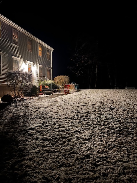
- Today
-
11/15/18
-

Central PA Fall Discussions and Obs
mahantango#1 replied to ChescoWx's topic in Upstate New York/Pennsylvania
Yep, I'm sick of it too. And it's only just the beginning. What happens if we get a few 12in. Plus snowstorms and then wind days on end. -
It’s phenomenal and worth a pick up.
-

November 2025 general discussions and probable topic derailings ...
powderfreak replied to Typhoon Tip's topic in New England
That is a crazy snow cycle... and wild melt afterwards. But 43" on 4.9" of liquid is a big cycle. Wow. Honestly, it's probably about the current cycle ratios we've seen, 10:1 or under... but with twice the QPF. -
Days like today make me miss summer, can’t wait for it to return. Wife due in May, so hopefully have the whole summer off to enjoy the baby and the weather
-

November 2025 general discussions and probable topic derailings ...
Ginx snewx replied to Typhoon Tip's topic in New England
-
On this date in 2018 didn’t we get a nor’easter with record snow? Was barely predicted?
-

November 2025 general discussions and probable topic derailings ...
ineedsnow replied to Typhoon Tip's topic in New England
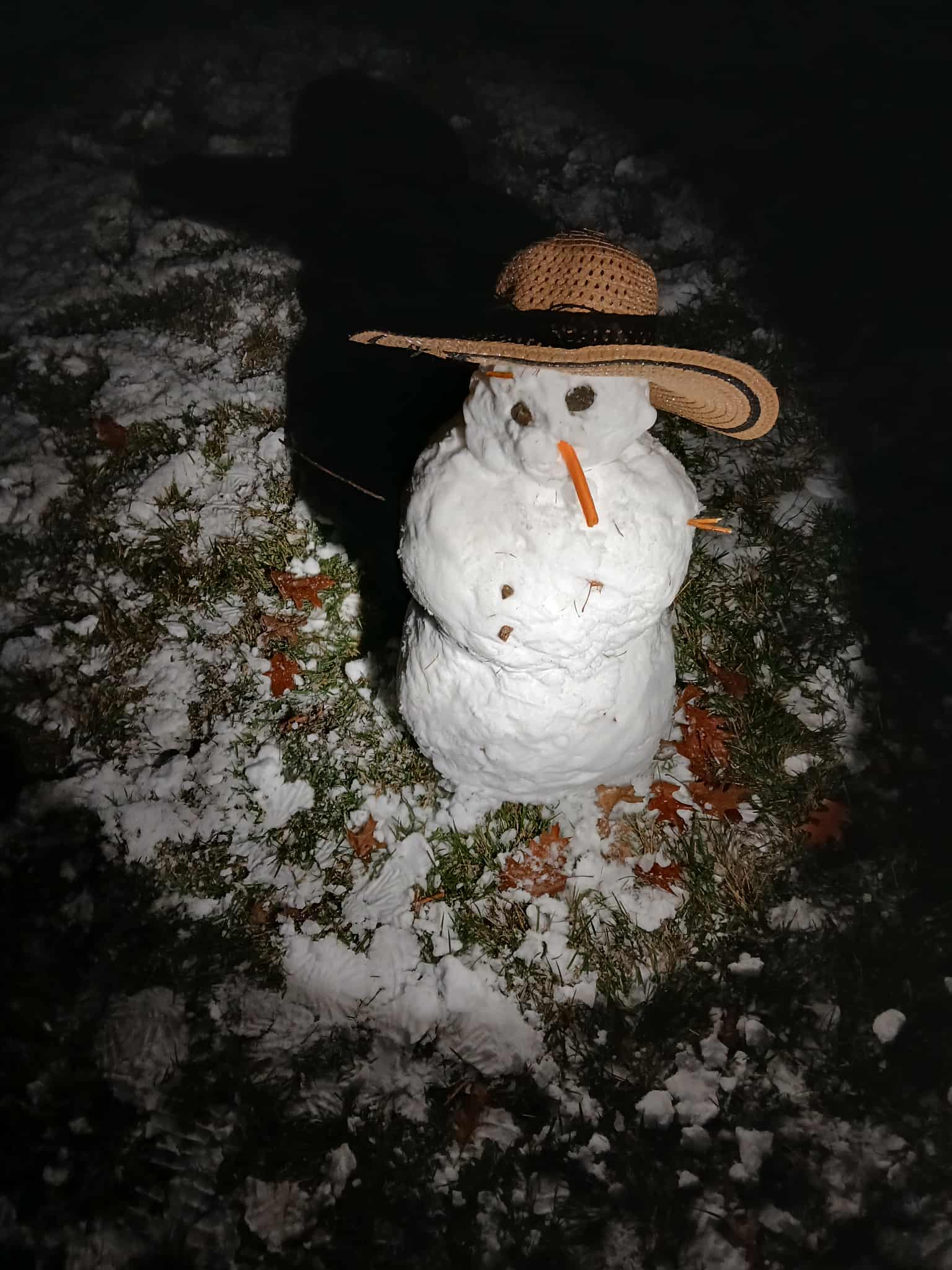
First snowman of the year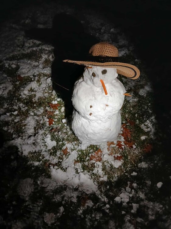
-
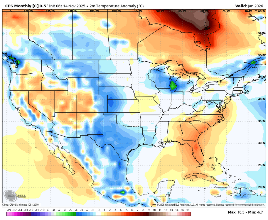
Making the CFS even wackier is when it is a WxBell version: -For one thing their versions almost always have an odd cold spot over Lake Michigan along with a warm spot to the NNE near the E UP of Mich. -The wackiest maps are the control runs (C) as opposed to ensemble mean (M) runs Here’s another example: cold spot over L Mich. (to -6C, which would be close to coldest on record) while there’s a warm spot of +4C over NE UP of Mich!
-
November 2025 general discussions and probable topic derailings ...
powderfreak replied to Typhoon Tip's topic in New England
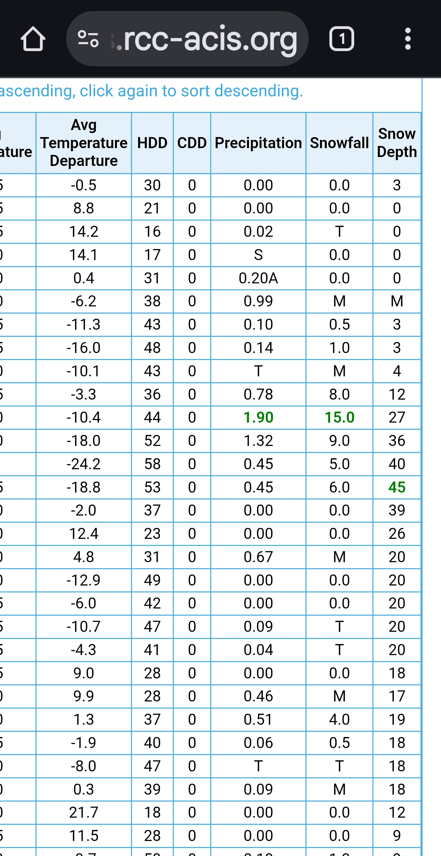
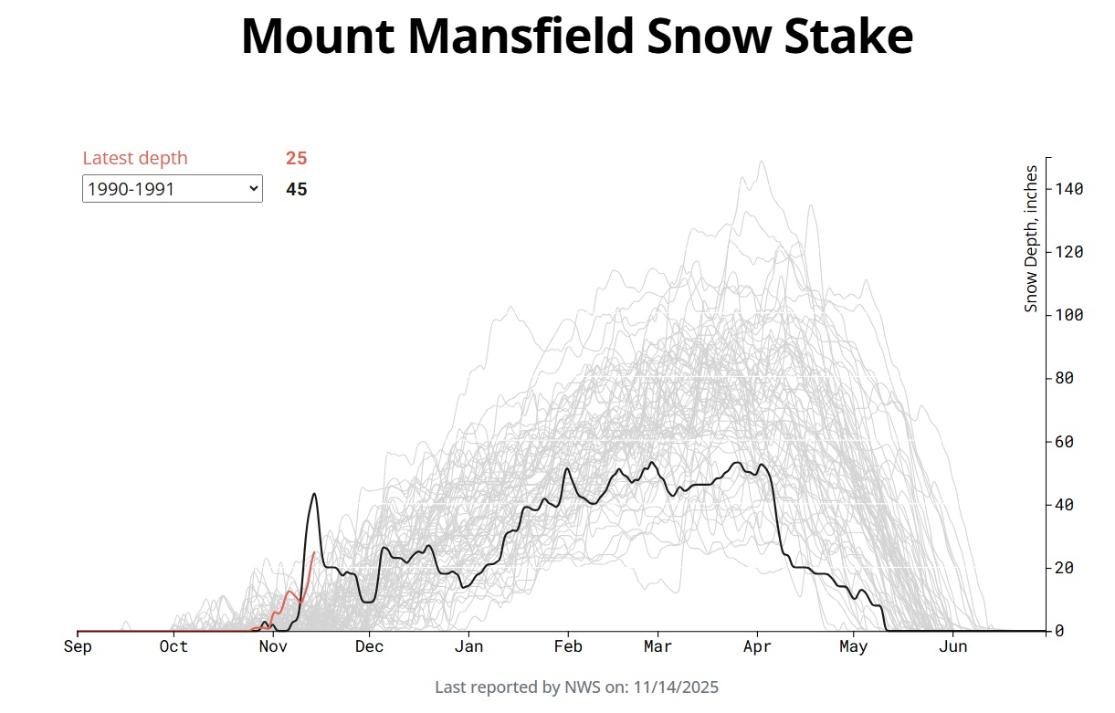
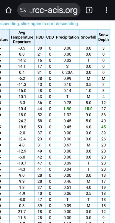
Starting off the season with a bunch of dense snow. Interesting that while 25" is more than 69 other recorded winters, as one can see with the 45" on this date in 1990-1991 that it didn't mean much for the rest of the winter, ha. I'll have to look up what happened around this time in 1990. That must've been a monster event or couple of events to go from like near 0" to 45" of depth in a week or less. Then to lose it almost as fast. It's interesting that spike in snowpack is so far above anything else in the long recorded history. 70+ years of records and that one spike is like 50% higher than the next highest season.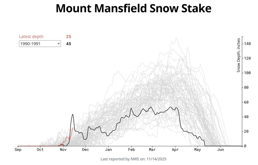
-
.thumb.png.4150b06c63a21f61052e47a612bf1818.png)
November 2025 general discussions and probable topic derailings ...
HIPPYVALLEY replied to Typhoon Tip's topic in New England
As did WRF-ARW -
 But did they have the fun he had ?
 -
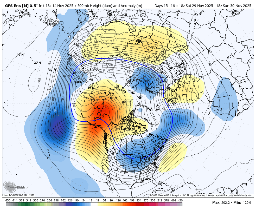
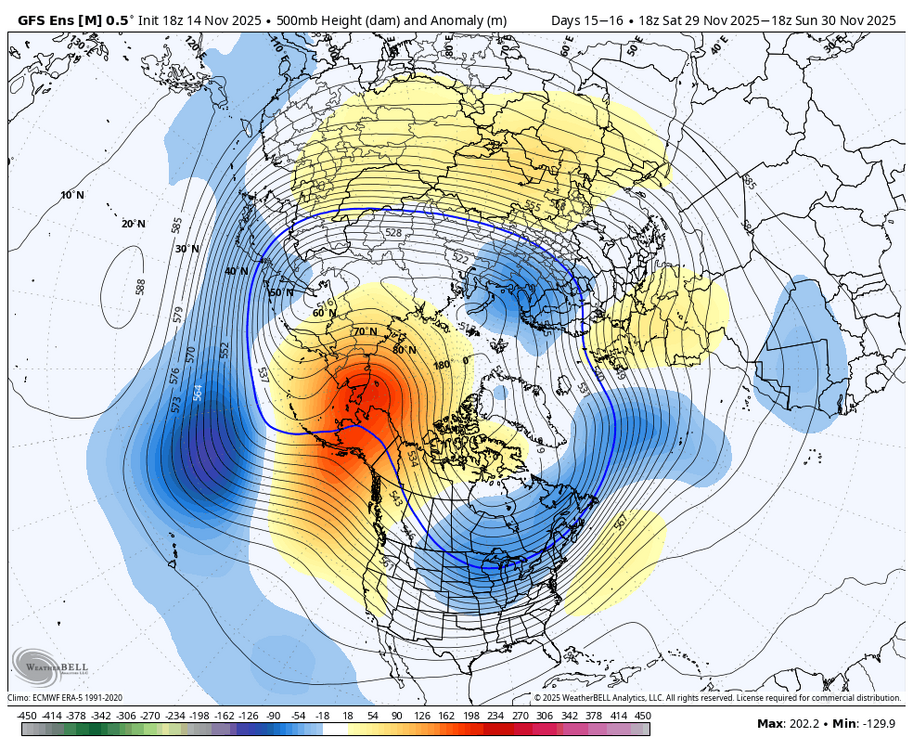
Love that deep trough NW of Hawaii. You don't can kick when the players are in position - it would take a whole re-alignment of the N. Pacific 500mb pattern, which is a little bit beyond the average model error. I think the wild card is the MJO and what it does. Seems models are betting on it staying strong. They want to have more of a -PNA pattern if the MJO goes weak, but I'm not seeing it: 21 of the last 29 months have been +PNA [CPC], and since the 23-24 Strong Nino flipped to negative-ENSO, 12 out of 19 months have been +PNA.
-

November 2025 general discussions and probable topic derailings ...
dendrite replied to Typhoon Tip's topic in New England
12z 3k NAM had SHSN moving through there -
Nice to see the GEFS today at the end of its ens run show the pattern the weeklies have been showing. Always the risk of a can kick. My biggest concern has been that the trough gets stuck in the west and delays the cold coming east. Seems that risk is slowly decreasing. The 5-10th once cold is established it may be game on.
-
November 2025 general discussions and probable topic derailings ...
HIPPYVALLEY replied to Typhoon Tip's topic in New England
Wow, you must’ve been in a pretty narrow band. We got about three minutes of very light rain in Grittyfield and nothing since. -
November 2025 general discussions and probable topic derailings ...
ineedsnow replied to Typhoon Tip's topic in New England
NEAR TERM /THROUGH SATURDAY/... Key Point *Cold but less windy overnight. Wind chill values in the low 20s. One last round of weak shortwave energy moves through the region this evening before the stalled upper-level trough and cold pool move well offshore. Not anticipating anything other than increased cloud cover this afternoon and evening, as dry low-level air will make it difficult for any rain to reach the ground. Clouds begin to decrease tonight -
November 2025 general discussions and probable topic derailings ...
ineedsnow replied to Typhoon Tip's topic in New England
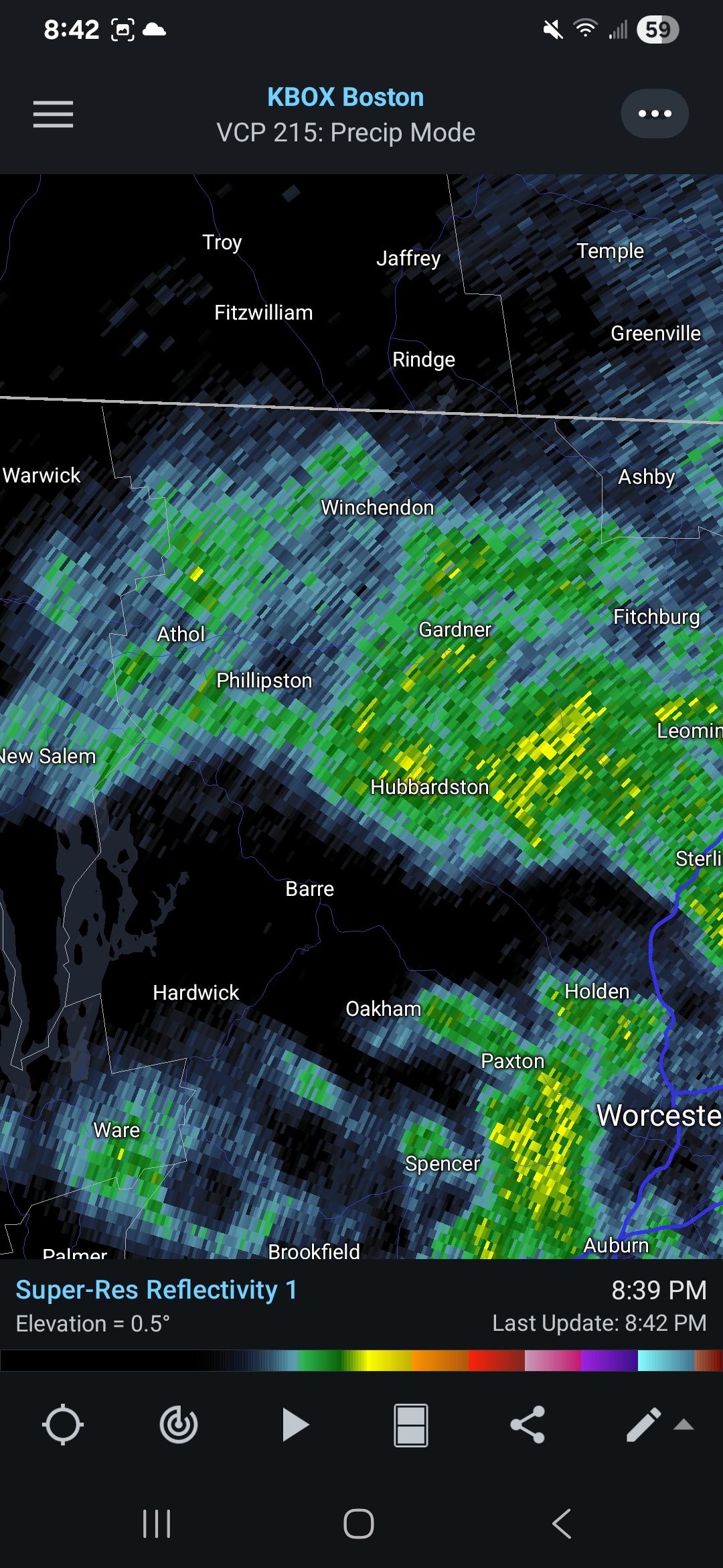
No model had this..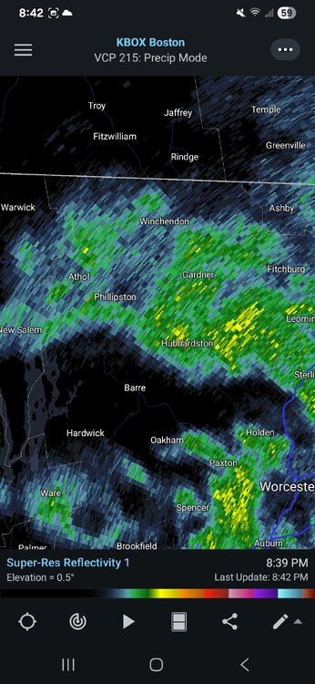
-
November 2025 general discussions and probable topic derailings ...
ineedsnow replied to Typhoon Tip's topic in New England
Lol yup I feel like a kid on these days Feels great seeing the ground whiten again.. closing in on a inch still light to mod.. wasn't expecting this at all -
Fair point. It's an online setting. I added the /s.